NOAA/National Weather Service, National Centers for Environmental Prediction, Room 808, Camp Springs, Maryland 20746 - USA
FIGURES
Abstract
Introduction
The NOAA/National Weather Service (NWS) has been issuing a next day
UV Index forecast for locations within the United States since the summer
of 1994. The UV Index forecast incorporates satellite observations of the
earth's ozone field, a radiative transfer model, and atmospheric parameters
from a numerical weather forecast model. As with all other NWS forecast
products, the UV Index must be validated. At nearly the same time, several
U.S. governmental agencies have established surface ultraviolet radiation
observation networks. The UV Index forecasts are validated against these
observations.
In addition to providing validation information to the NWS, this process
is unique in that it combines all of the different networks' observations
and compares them against an independent source. In the past, this has
lead to uncovering calibration and characterization problems with specific
instruments and an entire brand of instrument. Subsequently, these calibration
and characterization issues have been addressed and correction values are
made available to the user community.
Overview
As the NWS strives to improve the accuracy of the UV Index, it remains
an excellent independent source of comparison for surface UV observations.
The UV Index is a dose rate of erythemally weighted UV irradiances. The
U.S. National Weather Service (NWS) produces a daily forecast of the UV
Index for the following day valid during the local solar noon hour for
nearly 800 U.S. cities(Long, et al., 1996). Total ozone forecasts based
upon observations from NOAA satellites, cloud forecasts from NCEP numerical
models provide the necessary input for the daily UV Index forecasts. No
surface UV observation information is used in the generation of the daily
forecasts.
There are no less than seven networks taking surface UV radiation observations
operated by various governmental agencies. Each network has its own specific
purpose. Which directs the locations of the surface sites. For this exercise,
three of the larger networks were chosen: USDA, NOAA's SURFRAD, and EPA's
UVnet.
The USDA and the SURFRAD networks use the Yankee UV-B broadband instrument
to make their surface observations. The EPA uses the spectral Brewer Mk
IV. More information about these instruments can be found at the networks
home pages.
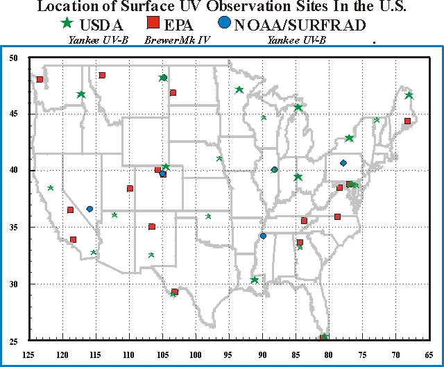
Figure 1 shows the location of the three networks' sites within the contiguous 48 states. Note that there are several locals where more than one network is located. This offers the chance for inter-comparison of the observations.
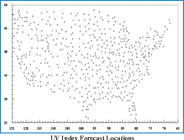
Figure 2 shows the locations of nearly 800 cities where the UV
Index forecasts are issued. Stations closest to the surface observation
sites are used for this comparison. Some parings of UV observation site
and UV forecast city have small distances between them. While others, especially
for the sites in National Parks, are much further away.
Characterization Factors
In previous comparisons surface observations made by the Yankee UV-B
instrument using the manufacturer's conversion factors produced values
with a high bias by as much as 10%.
The NOAA Central Ultraviolet Calibration Facility characterized this
instrument and determined conversion factors that varied with both solar
zenith angle and total ozone amount(see Figure 3). Once applied, agreement
between the Yankee instrument observations and the UV Index forecasts increased
tremendously. Therefore, whenever using surface observation data, one must
be certain that the correct scaling and calibration factors have been used.
Usually, 'readme' files accompany the data sets, but a phone call to the
network manager reassures that the data is used properly.
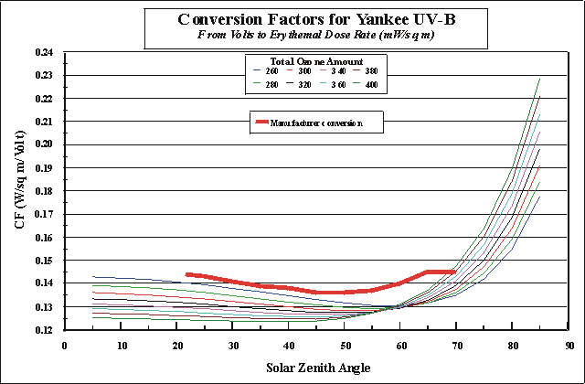
Figure 3
Overall Results
Differences between the observed and forecast UV Index values at all the sites for each of the three networks have been determined. Histograms of these differences for each of the networks are presented in Figure 4.

Figure 4
Note the high number of occurrences for the -1 to +1 UV Index differences
for the USDA and the SURFRAD. The great number of these occurrences implies
that there is great consistency between the observed and the forecast UV
Index values throughout the two networks. However, the EPA histogram results
imply a greater inconsistency between observed and forecast UV Index values
among its network sites. The high consistency for the USDA and SURFRAD
sites imply that similar differences would be expected any where the UV
Index was forecast.
The histograms also show one weakness of the UV Index forecasts. The
relatively disproportionate number of differences of negative values (-3
to -5) indicate that many times the UV Index forecasts are much greater
than the observations. As will be shown below, this occurs when overcast
conditions occur. The forecasts allows too much UV radiation to transmit
through the clouds.
Also, the SURFRAD histograms exhibit a positive bias. This is interesting since the same type of instruments are used as the USDA which exhibits no bias at all.
Sample Comparison of Surface Observatons and UV Index
Forecasts
A good example of how well the UV Index forecasts and observations agree
is shown in Figure 5.
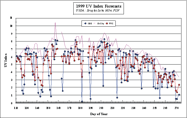
Figure 5
This figure shows how the forecasts and observations are compared "by
eye". Besides the observations and the UV Index forecasts, the "clear
sky" UV Index forecasts are also shown. This provides a indicator
of the maximum values at each particular site. The only factors affecting
this value is the solar zenith angle and the total ozone amount. Note that
the day-to-day variation of total ozone does introduce variations in the
clear sky amounts. Note also, the number of occasions when overcast conditions
occur and the large differences between observed and forecast UV Index
amounts. As explained above, the large differences that occur when overcast
conditions exist show up on the negative side of the histograms.
Multiple Comparisons at one Local
As stated earlier there are several locals in the U.S. which have more than one network taking observations. This allows for intercomparisons between the observations and can also be used to exhibit the validity of the UV Index forecast as a unbiased comparison standard.
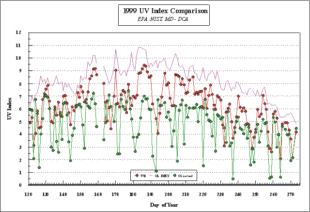
In Figure 6, the observations from the EPA Brewer at the National
Institute for Standards and Technology (NIST) in the northern suburbs of
Washington D.C. show a large difference from the UV Index forecasts. These
large differences could raise concern for the validity of the UV Index
forecast.
However, in the eastern suburbs, in Beltsville, MD is a USDA site.
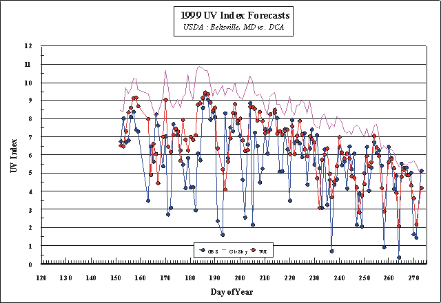
Figure 7 shows much better agreement. Knowing that similar agreement
at the other USDA sites implie that the UV Index forecasts are reliable.
As a result, the data from the EPA Brewer is then questionalbe. This same
situation occurred at the Table Moutain site outside of Boulder, CO. This
time data from a Brewer exhibited a very low bias against the UV Index
forecasts. A co-located SURFRAD instrument had a much lower bias. This
suggests that this Brewer's data is questionable. This does not mean that
data from all the other Brewers is questionable. Other sites compared very
well with UV Index forecasts.
One on One Comparisons
During the time period of these intercomparisons, differences normalized to remove the annual cycle, should remain constant. When they do not is another indication of a calibration shift in the instrument.
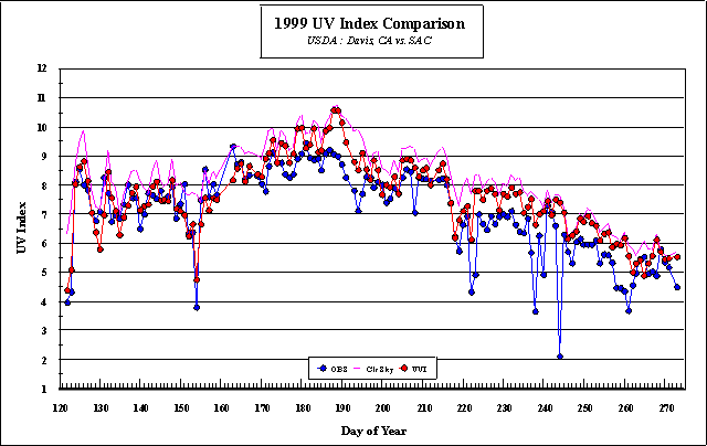
Figure 8 shows the observations and UV Index forecasts for Davis,
CA. Davis characteristically has very clear skies throughout the May to
August time period.
Visual inspections of the time series suggests a change in the differences
of the obserations and forecast values around day 190. Ratios of the normaled
observations and forecasts are shown in Figure 9. Ratios are centered near
the zero line to about day 160. The ratios following consistenly lower
implying a calibration shift.
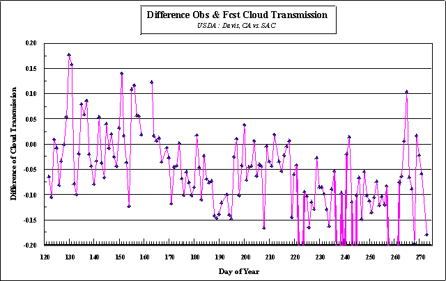
Figure 9
Conclusions
The consistency of differences between the UV Index forecasts and observations
from two surface UV networks implies the viability of the UV Index forecasts
at other locals. This was shown were comparisons against observations made
by one instrument had a consistent bias, but comparisons against another
instrument in the same local had nearly zero bias. Thus, observations from
sites with consistently large biases from the UV Index forecasts would
be under suspect.
The UV Index forecasts can also be use to detect unexplained changes in the observation record during the course of the time period. These attributes allow a network data manager or a single observer to use the UV Index forecasts as a first indicator of problems with an instrument.
Back to
| Session 1 : Stratospheric Processes and their Role in Climate | Session 2 : Stratospheric Indicators of Climate Change |
| Session 3 : Modelling and Diagnosis of Stratospheric Effects on Climate | Session 4 : UV Observations and Modelling |
| AuthorData | |
| Home Page | |