Previous: Mean Fields Next: ConclusionsUp: Ext. Abst.
4. Case Study
4.a Synoptic
Evolution
During
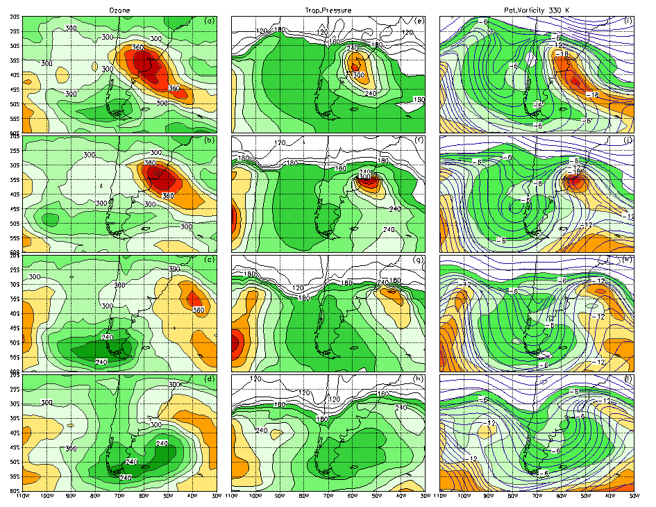
the second week of the month, strong ozone perturbations were detected
over southern SA, consisting of a transient ozone wave evolving with a
southwest-northeast direction across the continent. From July 7th
to10th (figs.4a-d) ozone values as low as 240 DU could be followed
along four days from southern Patagonia to southwestern Atlantic. At the
same time, high ozone values (up to 400 DU -fig.4b-) were observed to evolve
over Buenos Aires and to the east.
The
analogous evolution of the atmospheric fields shows a clear correspondence
between ozone relative minimum (maximum) and: ridges (troughs), lowered
(enhanced) tropopause pressure values (figs. 4e-h) and relative maximum
(minimum) of potential vorticity on isentropic surfaces (figs. 4i-l). By
use of a simple conceptual model, Vigliarolo et al. (2000) exhibited the
dynamical relationship between a synoptic wave and the resulting ozone
distribution, provided ozone-mixing ratio is conserved on these time scales.
Moreover they showed by composite analysis for the preferred winter synoptic-scale
mode of variability, that waves evolving along subpolar jet latitudes are
responsible for the corresponding transient ozone-pattern. This is due
to the barotropic-equivalent structure of these waves and the fact that
ozone partial-pressure attains a maximum very close to the level where
these waves also maximise.
In
order to address the relative dynamical contributions of the atmospheric
waves to ozone changes over southern SA region, two approaches are followed.
The first, relates ozone daily changes to horizontal and vertical transports
of ozone mixing ratio by transient motions (subsection 4b), while in the
second ozone distribution is fitted to a multivariate linear relationship
with tropopause pressure and potential vorticity at several isentropic
levels (subsection 4c).
Figure 4: Temporal
evolution from July 7th to 10th of: (a)-(d) ozone,
(e)-(h) tropopause pressure, (i)-(l) potential vorticity (shaded) and streamlines
(thick contours) on the 330ºK surface. Contour interval is (a)-(d)
20 DU; (e)-(h) 20 hPa; and (i)-(j) 2*10-8 m2 s-1
kg-1.
4.b Mapping Technique
A
mapping technique was used to provide estimates of three dimensional ozone-mixing
ratio horizontal gradients based on Meteor 3/Toms total ozone and SBUV/2-
NOAA 11 ozone mixing ratio vertical distribution. This technique allows
meridional ozone mixing ratio estimations supposing a linear relationship
between the former and the meridional ozone gradient. Then, the same derived
linear coefficients are used to estimate zonal ozone mixing ratio gradients
from total ozone zonal gradients. It is worth to note that for July 7th
to 10th, the SBUV/2 profiles used correspond to the scan of
the satellite that passes over the continent, as the subsequent scans are
spread about 25º east and west. Hence, the validity of the above assumptions
is much accurate in a domain close to the satellite path. In addition,
only data from 100 to 30-hPa were used, as above that upper boundary the
dispersion relationship between the "mapped" variables becomes
non-significant.
With
a similar procedure, we also estimate three-dimensional ozone mixing ratio-distribution
in terms of total ozone distribution and SBUV/2 ozone mixing-ratio profiles.
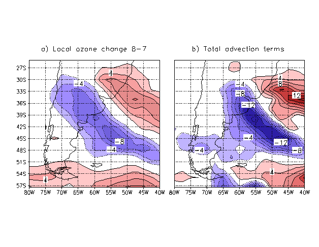
Figure 5: (a) Local
ozone change from July 8th to 7th and (b) total (zonal,
meridional and vertical) advection contributions to ozone changes integrated
over the 100-30 hPa layer. Contour interval 2*10-4 DU s-1,
all zero contours have been omitted.
The
most simple transport ozone equation where the ozone-mixing ratio is conserved
following the motion is:
![]() (1)
(1)
where
![]() stands
for ozone mixing ratio, u and v are the horizontal wind components
and
stands
for ozone mixing ratio, u and v are the horizontal wind components
and ![]() is
the vertical velocity. Then multiplying by the appropriate quantities and
performing a vertical integration of (1), ozone local changes between two
close pressure levels may be obtained as the combined response of both
horizontal and vertical transports of ozone mixing ratio integrated in
the pressure layer.
is
the vertical velocity. Then multiplying by the appropriate quantities and
performing a vertical integration of (1), ozone local changes between two
close pressure levels may be obtained as the combined response of both
horizontal and vertical transports of ozone mixing ratio integrated in
the pressure layer.
In
that sense, local ozone change between July 8th and 7th
is shown in fig.5a while the contributions from zonal, meridional and vertical
(total) advection terms integrated in the 100-30 hPa layer is shown in
fig.5b. Both fields are in good agreement although the total advection
field overestimates ozone local changes by approximately a factor of 1.7.
This may be due to: a) the poor estimates of the vertical velocity field
in the stratosphere, which may be very low compared to the real ones. b)
The limitation of the mapping technique itself for levels above 30-hPa,
although the analysis of SBUV/2 profiles over the region indicate that
the contribution to local ozone changes came from the 125-62.5 hPa layer,
with secondary contributions coming from both 62.5-37 hPa and 250-125 hPa
layers. c) The transports taken only from 100 to 30-hPa, which may be misrepresenting
the real situation.
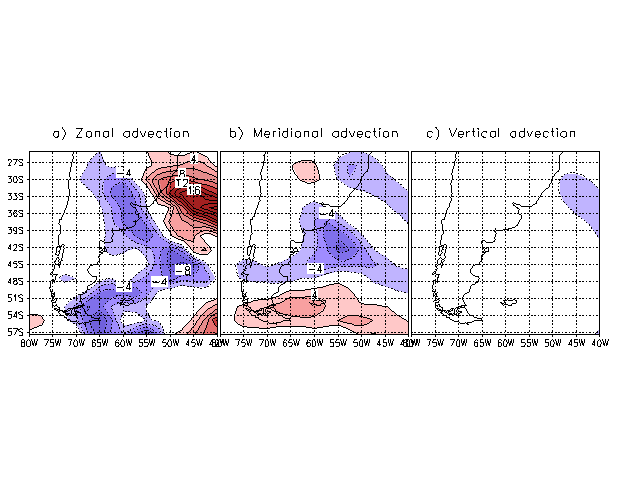
Figure 6: Contribution
to total advection for July 8th to 7th from (a) zonal,
(b) meridional and (c) vertical motion fields; each integrated over the
100-30 hPa layer. Contour interval 2*10-4 DU s-1,
all zero contours have been omitted.
For
the same day, each component of the total advection term integrated over
the 100-30 hPa layer is shown in fig.6. Negative local ozone changes over
the central part of Argentina and extending south-east to the Atlantic
ocean are due to the combined contribution of both zonal and meridional
advection. Meanwhile, the positive ozone changes located to the north of
Uruguay and eastern Atlantic come from the zonal advection term partially
offset by meridional and little vertical advection. To the eastern part
of Tierra del Fuego and over 57ºS, 55ºW too much negative values
are produced by the zonal advection term, although ozone changes over the
region are positive (fig.5a).
4.c Lineal
multivariate regression model
Suggesting
that total ozone variability on synoptic time-scales is mostly explained
by quasi-columnar motion of air
along isentropic surfaces, Salby and Callahan (1993) derived a linear regression
model that relates total ozone content to tropopause pressure and potential
vorticity. In order to test this hypothesis and to find suitable predictors
for ozone distribution, the following relationship was proposed:
![]() (2)
(2)
where
![]() is
total ozone,
is
total ozone, ![]() represents
the tropopause pressure,
represents
the tropopause pressure, ![]() stands
for the potential vorticity on isentropic surfaces of 315ºK, 330ºK
and 450ºK, and
stands
for the potential vorticity on isentropic surfaces of 315ºK, 330ºK
and 450ºK, and ![]() ,
i=0, 4 are the corresponding
regression coefficients.
,
i=0, 4 are the corresponding
regression coefficients.
To
find the regression coefficients that fit the relationship given by (2),
data from the entire month of 1994 July was used according to least square
method. Then, (2) was resolved for the grid points of the SH when the corresponding
time series of the variables involved have no gaps within the month. As
an example, figure 7a shows the time evolution of the relative contributions
from terms in (2) averaged over 35º-55ºS, 50º-70ºW,
an area that encloses the eastern part of southern SA. Contributions from
all terms (tropopause pressure and the sum of potential vorticity contributions)
are in very good agreement with ![]() almost over the whole month, excepting in the period July 25th
to 30th when the differences between each curve become the largest
(about 28 DU). Apart from some few days at the beginning of the month,
potential vorticity remains the main contributor to
almost over the whole month, excepting in the period July 25th
to 30th when the differences between each curve become the largest
(about 28 DU). Apart from some few days at the beginning of the month,
potential vorticity remains the main contributor to ![]() , while an analysis of potential vorticity terms discriminated for isentropic
surfaces (fig.7b) shows that pv315
is the most important term, which in turn is comparable to tropopause
pressure contribution.
, while an analysis of potential vorticity terms discriminated for isentropic
surfaces (fig.7b) shows that pv315
is the most important term, which in turn is comparable to tropopause
pressure contribution.
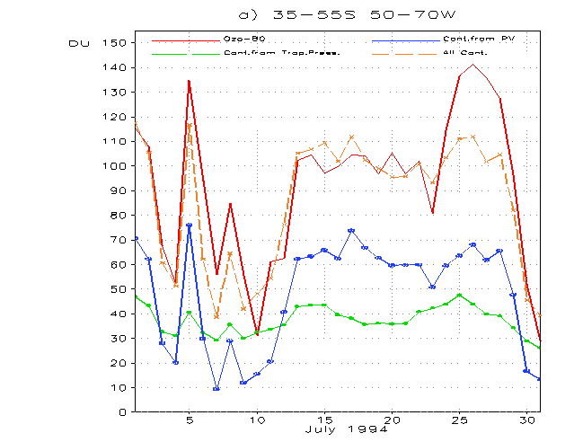
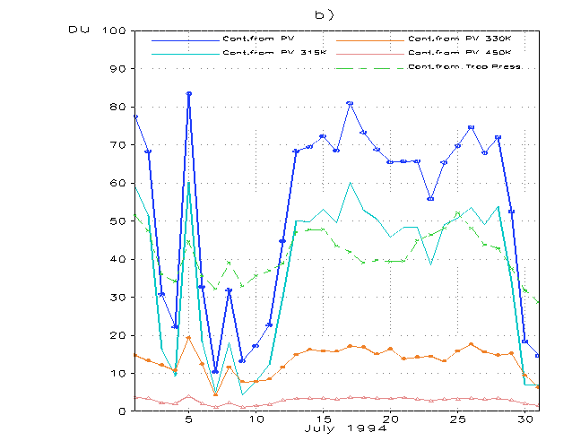
Figure 7: Time evolution
of contributions from the different terms in (2). (a) ![]() is represented by the continuous
curve in red; contribution from tropopause pressure is labelled in green
while that belonging to the sum of all potential vorticity at 315ºK,
330ºK and 450ºK is denoted by blue. The long dashed orange line
represents the sum of all contributions (from tropopause pressure and potential
vorticity). (b) Individual contributions from potential vorticity at 315ºK
(light blue curve), 330ºK (orange) and 450ºK (rose); the sum
of all this contributions are labelled in blue while contribution from
tropopause pressure (green long-dashed) was plotted for comparison purposes.
is represented by the continuous
curve in red; contribution from tropopause pressure is labelled in green
while that belonging to the sum of all potential vorticity at 315ºK,
330ºK and 450ºK is denoted by blue. The long dashed orange line
represents the sum of all contributions (from tropopause pressure and potential
vorticity). (b) Individual contributions from potential vorticity at 315ºK
(light blue curve), 330ºK (orange) and 450ºK (rose); the sum
of all this contributions are labelled in blue while contribution from
tropopause pressure (green long-dashed) was plotted for comparison purposes.
For
July 8th, figure 8 presents: (a) ![]() field, and the contributions from: (b) the sum of potential vorticity from
the three isentropic levels and (c) the tropopause pressure over southern
SA. In particular, over the western Pacific, southern Patagonia and Malvinas
Islands, and the band extending from the continent at 43ºS into the
Atlantic Ocean to the east, relatively low values of the
field, and the contributions from: (b) the sum of potential vorticity from
the three isentropic levels and (c) the tropopause pressure over southern
SA. In particular, over the western Pacific, southern Patagonia and Malvinas
Islands, and the band extending from the continent at 43ºS into the
Atlantic Ocean to the east, relatively low values of the ![]() field are mainly due to decreased tropopause pressure (figs.8c-4f) and
relatively low potential vorticity (figs.8b-4i). On the other hand, high
values of
field are mainly due to decreased tropopause pressure (figs.8c-4f) and
relatively low potential vorticity (figs.8b-4i). On the other hand, high
values of ![]() over north of Uruguay and southeastward over the Atlantic (fig.8a) are
due to relatively low potential vorticity (fig.8b-4I) and tropopause pressure
enhancement (fig.8c-4f) both linked to a cyclone evolution over the area.
over north of Uruguay and southeastward over the Atlantic (fig.8a) are
due to relatively low potential vorticity (fig.8b-4I) and tropopause pressure
enhancement (fig.8c-4f) both linked to a cyclone evolution over the area.
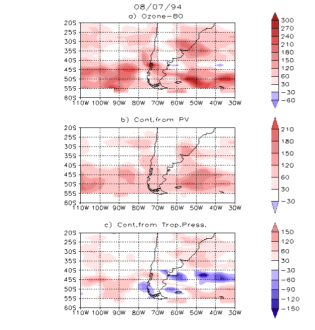
Figure 8: (a) ![]() field, and the contributions
from (b) the sum of terms of potential vorticity from 315ºK, 330ºK
and 450ºK, and (c) tropopause pressure. Contour interval is 30 DU.
field, and the contributions
from (b) the sum of terms of potential vorticity from 315ºK, 330ºK
and 450ºK, and (c) tropopause pressure. Contour interval is 30 DU.
Previous: Mean Fields Next: ConclusionsUp: Ext. Abst.