
Istituto di Ricerca sulle Onde Elettromagnetiche (IROE) - CNR, Via Panciatichi, 64 I-50127 Firenze, Italy
Istituto di Spettroscopia Molecolare (ISM) - CNR, Bologna, Italy
Queen Mary and Westfield College (QMW) - London, UK
FIGURES
Abstract
Introduction
Geographic variability of vertical Volume Mixing Ratio (VMR) profiles of various compounds involved in stratospheric ozone chemistry are derived from data acquired by the SAFIRE/A (Spectroscopy of the Atmosphere by using Far Infrared Emission/ Airborne) spectrometer. During the APE-GAIA Antarctic campaign (Airborne Polar Experiment - Geophysica Aircraft In Antarctica), performed from Ushuaia, Tierra del Fuego (Argentina) between 16th September and 15th October 1999, the SAFIRE/A instrument measured the concentration of ozone, other chemical species involved in the ozone chemistry, as HNO3 and ClO and tracers as N2O. Five scientific flights have been performed crossing the Antarctic polar vortex boundary. The volume mixing ratio profiles, acquired in a region extending from 57 to 68 degrees of latitude south, cover the lower stratosphere (10-20 km) with a vertical resolution of about 1.5 km and an horizontal resolution of 60 km. Chemical processes involving ozone inside the polar vortex are evidenced in the presented data by correlation of the geographic and vertical variability shown in the VMR maps of Ozone and chemically active species like HNO3 and ClO.
SAFIRE/A operation during the APE-GAIA campaign
SAFIRE-A (Spectroscopy of the Atmosphere using Far-InfraRed Emission / Airborne) [1] is a polarising far infrared Fourier transform (FT) spectrometer operating onboard the M55 Geophysica stratospheric aircraft. In the five scientific flights which the aircraft performed over the Antarctic Peninsula, during the APE-GAIA (Airborne Polar Experiment - Geophysica Aircraft In Antarctica) campaign, the instrument provided limb sounding observations of atmospheric emission spectra over two frequency intervals: [22-23.5 cm-1], and [123-125 cm-1] where spectral features respectively of O3, ClO, N2O, HNO3 and HCl, H2O are displayed. Some of the principal characteristics of the SAFIRE/A instrument are presented in table 1.
| Instrument type | Polarising FTS |
| Dimensions | 1800 x 880 x 650 mm |
| Weight | 387 Kg |
| Observation technique | limb-scanning |
| Acquisition time | 12-24-48-96 s |
| Number of detection channels | 2 |
| Operating spectral range | 10-250 cm-1 |
| Spectral resolution | 0.004 cm-1 |
| Vertical resolution | about 1.5 km |
| Spectral signal-to-noise ratio | >500 |
| Vertical field of view | 0.57o |
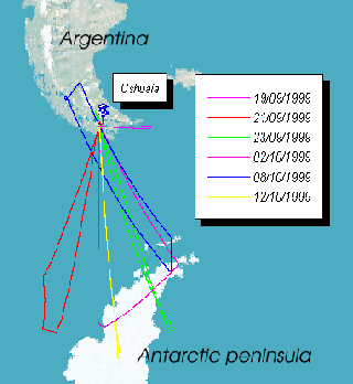
In figure 1 the flight tracks corresponding to each of the scientific flights
performed during the APE-GAIA campaign are shown. The choice of
the Ushuaia international airport as a base for the campaign permitted
to explore the Antarctic polar vortex region, spanning a latitude
range from 58 to about 68 degrees south.
 |
During each flight the SAFIRE/A instrument vertically sampled the atmosphere with limb sounding sequences of 10 emission spectra, corresponding to a vertical resolution of about 1.5 km. The acquisition time for a single spectrum was 30 s, each sequence taking about 5 minutes. This, considering the aircraft average ground speed of 700 km/h at stratospheric altitude, gave an horizontal resolution of about 60 km, corresponding to 0.5 degrees of latitude. The amount of valid data acquired by SAFIRE/A in each flight is given in table 2 as a percentage of the total recorded data.
| Scientific flight | Data acquired | Failure reason |
| 19/9/1999 (test) | 0% | photolitographic BS, aircraft roll |
| 21/9/1999 | 60% | reference laser, roll |
| 23/9/1999 | 90% | roll |
| 2/10/1999 | 30% | roll |
| 8/10/1999 | 100% | - |
| 12/10/1999 | 100% | - |
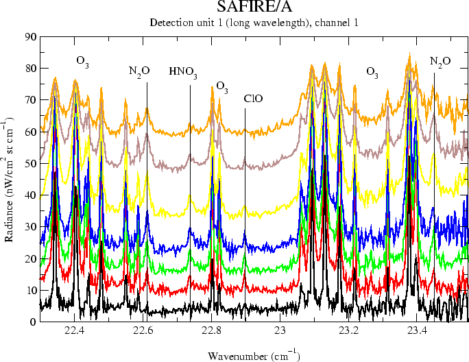
In figure 2 a typical limb scanning sequence of spectra acquired from the
long wavelength detection channel (22-23.5 cm-1) of the instrument is shown. The simultaneous presence in the
same spectral interval of both chemically active species, like
ozone, HNO3 and ClO and tracers, like N2O permits to obtain a characterization of chemical and dynamical
processes in the lower stratosphere through correlation between
atmospheric components.
 |
First results: VMR maps of the observed species
Volume mixing ratio (VMR) values are derived from limb sounding sequences through a data inversion process [2]. The results obtained for ozone and ClO in the 23/9/1999 and 12/10/1999 scientific flights are shown in figure 3. The two flights considered were performed with a similar flight path, the only differences between the two flights were the different time of the day and the different conditions of the Antarctic vortex, respectively towards the end of the ozone depletion period and at the beginning of the recovery phase.
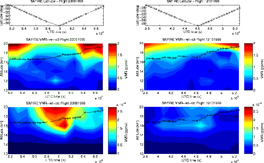 |
During the 23/9/1999 scientific flight activation of chlorine chemistry and ozone depletion inside of the polar vortex region is evidenced by anticorrelation between ClO and ozone concentration. The crossing of the vortex edge region is also marked by sharp VMR gradients. In the 12/10/1999 scientific flight the aircraft took off earlier in the morning, so that the diurnal cycle of chlorine activation still was at its start, and this, together with vortex de-activation at the end of Antarctic winter, determines lower concentrations of active Chlorine and less evident gradients in the vortex edge.
Another example in which the SAFIRE/A horizontal and vertical resolution were exploited was in the 8/10/1999 scientific flight. In this case a filamentation in the vortex edge was forecasted by atmospheric models, and the flight was aimed at crossing the interested region. In figure 4 VMR maps for ozone and nitric acid obtained from SAFIRE/A data acquired in the 8/10/1999 flight are shown.
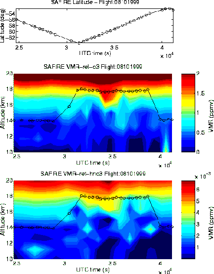 |
The filamentation is visible as a perturbation of VMR values in a well delimited region, crossed by the aircraft at about 35000 s UTC. Correlation between ozone and HNO3 further evidences this feature.
Validation of SAFIRE/A results
A test and validation of SAFIRE/A data analysis process is given by the comparison of ozone VMR values at flight altitude obtained from in-situ instruments and corresponding SAFIRE-A retrieved VMR values. In figure 5 is shown the comparison between ozone VMR at flight altitude as measured by the ECOC in-situ ozone sonde and SAFIRE-A during the 8/10/1999 scientific flight.
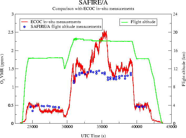 |
A general agreement is present between the two datasets in figure 5, as well as some occasional differences that are being analysed in order to understand how in-situ and remote sensing instruments may respond to atmospheric gradients.
Further validation of SAFIRE/A results come from the comparison of ozone VMR vertical profiles with those obtained from the MIPAS-STR [3] mid-infrared limb sounding FT spectrometer and from balloon-borne ozonesonde launched from the Marambio Antarctic base while the M55-Geophysica was flying over the base (figure 6).
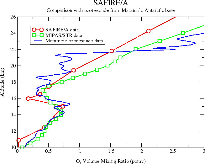 |
Even in this case we notice a good agreement, considering that the accuracy of data retrieved from limb sounding instruments is better near or below flight altitude.
References
| Session 1 : Stratospheric Processes and their Role in Climate | Session 2 : Stratospheric Indicators of Climate Change |
| Session 3 : Modelling and Diagnosis of Stratospheric Effects on Climate | Session 4 : UV Observations and Modelling |
| AuthorData | |
| Home Page | |