| CAFTON | • | Canadian FTIR Observing Network | ||
| CAFTON | • | Canadian FTIR Observing Network | ||
| Models CAFTON uses two atmospheric models, GEOS-Chem and STILT, to investigate processes related to the origin, concentration, and transport of airborne contaminants. GEOS-Chem The GEOS-Chem model is a global 3-D Chemical Transport Model (CTM) driven by assimilated meteorological data from the NASA Goddard Earth Observing System (GEOS) from the Global Modeling and data Assimilation Office (GMAO). The model includes a complete description of tropospheric O3-NOx-hydrocarbon chemistry. The most recent version of the meteorological fields from GMAO is based on the GEOS-5 system, which has a native horizontal resolution of 0.5° latitude x 0.67° longitude and 47 vertical levels from the surface to 0.01 hPa. Because of computational limitations, these fields are usually employed at a lower horizontal resolution of 2° x 2.5° or 4° x 5° in GEOS-Chem, however, the model can be run at the native resolution in a nested configuration over North America. The GEOS-Chem model also has ozone-, CO-, and C2H6-only simulation modes, in which the chemistry is linearized. For the CO-only and C2H6-only simulations, the linearization is carried out using OH fields archived from a full chemistry simulation, whereas the ozone-only simulation uses archived ozone production rates and loss frequencies. These linearized simulations enable tagging to characterize source-receptor relationships and easily quantify the contribution of different source regions to the simulated CO, C2H6, or O3 abundances. More detailed sensitivity analyses can be conducted in the full chemistry and tagged simulations using the GEOS-Chem adjoint, which enables computationally efficient calculation of the sensitivity of the model output to its inputs (i.e., it provides the partial derivatives, Jacobians). For example, the adjoint provides the sensitivity of CO abundances to emissions in every model grid box. It has been used to characterize source-receptor relationships for intercontinental transport, and forms the basis of the 4-D variational (4Dvar) data assimilation system in GEOS-Chem, which has been used to assimilate O3 data from TES and to optimize US aerosol sources using surface data and CO sources using MOPITT data. |
||||
| STILT The Stochastic Time-Inverted Lagrangian Transport (STILT) model transports air parcels backward in time with information derived from meteorological fields. Thus STILT derives the upstream influence region on atmospheric measurement locations at high spatial and temporal resolution. In this way, STILT serves as an efficient tool to retrieve the sensitivity of atmospheric tracer concentrations measured at receptor points with respect to upwind source regions. STILT simulates the transport of air parcels using ensembles of fictitious particles advected with velocities interpolated from meteorological fields. The effect of the turbulence is modelled by adding an additional random velocity to the mean motion for each particle. This random velocity is a function of the turbulence intensity and is different for each particle. |
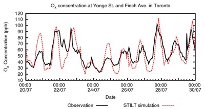 Comparison of STILT-simulated Ox (O3 + NO2) against observations at two monitoring sites in the Greater Toronto Area July 20-30, 2006. |
|||
| Recently, STILT was coupled with
the Weather Research and Forecasting (WRF) model, a
state-of-the-science mesoscale model widely in use by the
atmospheric science community. WRF yields high-resolution
meteorological fields generated from dynamical downscaling by
successive nests down to grid spacings of a few kilometres that
resolve atmospheric motions in the targeted region. The careful
coupling between WRF and STILT accomplished recently provides a way
to drive STILT particles using WRF meteorology in an integrated
fashion. The close coupling allows STILT to reproduce effects of
vertical mixing using convective mass fluxes as well as maintain
mass conservation. STILT has advantages over traditional approaches: (i) as a Lagrangian parcel model, the model concept is a closer physical analogue to natural phenomena involved in turbulent eddies as well as minimizing numerical diffusion; (ii) the ability to simulate concentrations at point locations, thereby reducing representation errors associated with discrepancies between grid-cell averaged values and point observations (e.g., on towers); (iii) a new, stochastic method to propagate and quantitatively account for errors arising from erroneous atmospheric transport. STILT also provides the nonlinear analogue to the adjoint of atmospheric transport, since no linearization is required. |
||||
