 |
Stratospheric Processes And their Role in Climate
|
||||||||
| Home | Initiatives | Organisation | Publications | Meetings | Acronyms and Abbreviations | Useful Links |
![]()
|
Stratospheric Processes And their Role in Climate
|
||||||||
| Home | Initiatives | Organisation | Publications | Meetings | Acronyms and Abbreviations | Useful Links |
![]()
Previous studies of stratospheric ozone trends (WMO, 1995; DeLuisi et al., 1994; McPeters et al., 1994; Reinsel et al., 1994; Miller et al., 1995, 1996) are summarised in Harris et al. (1997). They found that ozone amounts from approximately 1979-1991 had been declining at the rate of 5-10%/decade in northern mid-latitudes in the altitude region of maximum active chlorine (35-45 km). Those trend estimates were reasonably consistent between three measurement systems Dobson/Umkehr, SAGE I/II, and SBUV. The altitude-latitude structure of the measured ozone trends is also consistent with both the theoretical understanding of chlorine-catalysed ozone destruction (Solomon and Garcia, 1984; Kaye and Rood, 1989) and the measured latitudinal distribution of ClO (Aellig et al., 1996; Waters et al., 1996). Subsequent analyses of SAGE I/II trends through the same period employing an altitude correction for the SAGE I observations (Wang et al., 1996) reconciled differences between SAGE I/II and SBUV trends that had been present in the tropical lower stratosphere. Subsequent analysis of combined SBUV and SBUV2 [SBUV/SBUV2] trends (Hollandsworth et al., 1995), extended through 1994, did not substantially change that general agreement. These upper-stratospheric trends exhibited latitudinal and seasonal variations such that the trends were more negative in the winter and spring seasons at high latitudes. The trends in the tropical latitudes are less negative throughout the stratosphere and exhibit little seasonal or altitudinal variation. At somewhat lower altitudes (10-20 hPa ~30 km) these three systems, in addition to ozonesonde observations, concurred in finding no significant ozone loss at any latitude over the 1979-1991 period.
The deduced trends in ozone concentration are in general agreement with theoretical predictions (e.g., Chandra et al., 1995; Jackman et al., 1996) that implicate halogen-induced ozone destruction. The effect of the Montreal Protocol and its amendments is now apparent in measured tropospheric halogen amounts (Montzka et al., 1996), and similar declines in upper-stratospheric halogen levels are anticipated. Theoretical models predict a reversal in the ozone decline to occur near the end of this decade as a result of this decline in halogen amounts (Jackman et al., 1996).
One of the objectives of this report is to calculate the linear trends from measurements of stratospheric ozone through 1996. Because of the anticipated reversal in declining ozone amounts, subsequent studies will likely focus on detecting positive deviations from the negative linear trends established by these analyses. In the context of the Chapter 2 assessment of appropriate measurement systems for calculating stratospheric ozone trends, we consider times series of Dobson/Umkehr, SAGE I/II, and SBUV/SBUV2 observations from 1979 to 1996 [1994 for SBUV/SBUV2]. These data have been carefully screened such that only highly reliable measurements are used in the trend calculations.
3.5.1.1. Time series of Umkehr, SAGE I/II, and SBUV/SBUV2
We will begin by focusing on northern mid-latitudes and an altitude of 40 km (Umkehr layer 8). Before calculating trends, we first illustrate the time series from 1979 to 1996 [1994 for SBUV/SBUV2] of ozone observations from three independent sensors, Dobson/Umkehr (Figure 3.10a), SAGE I/II (Figure 3.11a), and SBUV/SBUV2 (Figure 3.12a).
Umkehr
The Umkehr observations in Figure 3.10a show the Boulder station as an example of the northern mid-latitudes. These monthly ozone averages, reported in natural Umkehr units of Dobson Units (DU) in the layer, are corrected for aerosol interference. The missing data periods result from eliminating observations during periods of very high stratospheric aerosol loading. The ozone values calculated by the statistical model also appear in the top panel and cover the missing data periods. The model residuals (i.e., the measurements minus the statistical model) for the Boulder Dobson/Umkehr record appear in the bottom panel as an example of the remaining statistical variance after removing the mean, trend, solar, and QBO terms.
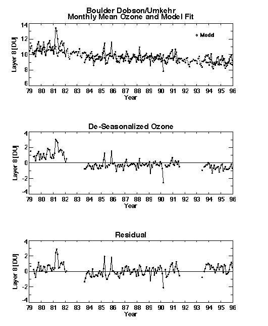
Figure 3.10 a) Monthly time series of layer 8 (40 km) ozone amounts [DU] from the Boulder Dobson/Umkehr station corrected for aerosol effects with periods of high stratospheric aerosol optical depth omitted. Also shown is the statistical model fit to this data. b) Deseasonalized data from Boulder. c) The residual between the data at Boulder and the model fit.
SAGE I and SAGE II
The SAGE I/II observations in Figure 3.11a are monthly averages of version 5.96 ozone retrievals in a 5-km thick layer between 38-43 km between latitudes 40°-50°N. These averages, which include both sunrise and sunset occultation measurements, are reported in the natural SAGE units of ozone number density versus geometric altitude.
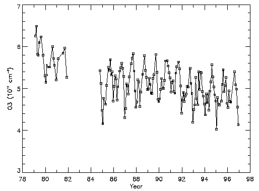
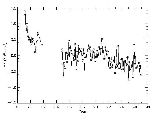
Figure 3.11 a) Monthly time series of layer 8 (38-43 km) ozone concentrations (1011cm-3) from SAGE I and SAGE II sunrise and sunset observations between 40°N-50°N. b) Deseasonalized data from a).
SBUV and SBUV2
Figure 3.12a shows the monthly-mean SBUV/SBUV2 ozone data in layer 8 from 1979 to 1994 averaged from 40° -50° North. These data are reported in natural SBUV units of DU versus pressure in Umkehr layers. The SBUV2 daily average 5° zonal means are filtered to eliminate data taken at extreme angles as a result of the NOAA-11 drifting orbit, consistent with Chapter 2 recommendations. Then 10o monthly zonal means are created from this data.
The corresponding, de-seasonalised time series for these three sensors appear in Figures 3.10b, 3.11b, and 3.12b for Umkehr, SAGE I/II, and SBUV/SBUV2, respectively. These measurements are all analysed and presented in their natural units to avoid uncertainties introduced by conversion errors. Taken together, a number of consistencies emerge. First, a significant ozone decrease between the SAGE I and SAGE II time periods (1982-1984) is apparent, with decreases of similar magnitude (~10%), in both the Umkehr and SBUV/SBUV2 observations. Second, the relatively constant level between 1984 and 1992 (with some suggestion of a slight increase between 1987-1990 in the SAGE series) and then a significant decrease after 1992 occurs in Umkehr and SAGE data but not in SBUV/SBUV2. Third, the amplitude of the annual variation is similar for all three sensors. The correspondence between these three independent ozone time series suggests that we should have considerable confidence in the trends computed from these data and should expect them to return similar results.
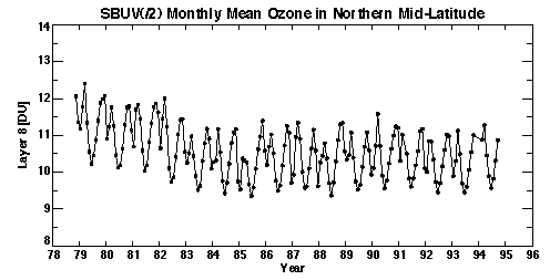
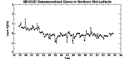
Figure 3.12 a) Monthly time series of layer 8 ozone amounts [DU] 40°N-50°N from the Nimbus-7 SBUV and NOAA-11 SBUV/2 data joined by adjusting the SBUV data by the average difference between the SBUV and SBUV/2 data over 1989. b) Deseasonalized data from a).
3.5.1.2. Trend Analyses of Umkehr Observations
The well-known aerosol interference in the Umkehr observations is an optical effect and not an in situ ozone-aerosol interaction. The following three methods have historically been employed to identify the magnitude of and correct for this aerosol interference: 1) theoretical radiative transfer calculations (Mateer and DeLuisi, 1992), 2) statistical calculations (i.e., time-series regression models employing exogenous aerosol records) (DeLuisi et al., 1994; Reinsel et al., 1994), and 3) comparisons to other ozone measurements (Newchurch and Cunnold, 1994).
In this report, to correct for the optical interference, we employ two methods. Method (1), employed by Newchurch and Yang, uses the coefficients of Mateer and DeLuisi (1992) with aerosol data from coincident SAGE II aerosol extinction measurements (Newchurch and Cunnold, 1994; Newchurch et al., 1995) along with Garmisch lidar backscatter measurements (H. Jaeger, private communication) for the period prior to 1984. The lidar backscatter measurements are converted to optical depths at 320 nm by regression against SAGE II coincident measurements over 1984 to 1995. The resulting continuous aerosol time series is then lagged appropriately to correct Umkehr data at various latitudes. Additionally, Umkehr data during high stratospheric aerosol optical depth periods (> 0.025 corresponding to ~1 year after El Chichon and ~1 year after Mount Pinatubo) are omitted from the analyses.
Method (2), employed by Reinsel, uses an empirical statistical model approach in which transformed stratospheric optical thickness (transmission) data are used as an explanatory variable for the Umkehr measurements. The stratospheric aerosol optical thickness data are constructed from SAGE II satellite information for the period 1985-1996. They are formed first by linear interpolation of SAGE II aerosol data available at wavelengths 1020, 525 and 453 nm to 694.3 nm, and then by linear combination of the integrated-from-tropopause and integrated-from-20-km data sets, to approximate aerosol optical thickness values integrated from 15 km (at 694.3 nm). The resulting data were appended to the previous existing optical thickness data based on composite lidar (and SAGE II) aerosol information through December 1984 (Reinsel et al., 1994). This procedure was performed separately for each of three ten-degree latitude zones, 30°-40°N, 40°-50°N, 50°-60°N. For the two southern hemisphere stations, only SAGE II aerosol data since 1985 were needed because the available Umkehr data from Lauder and Perth do not extend prior to that time.
Based on the close correspondence between the results of the three historically used correction methods for the aerosol conditions considered here, we conclude that the corrected ozone data possess less than ~2% residual error due to the aerosol interference in the worst case analysed here (immediately after the omitted periods following El Chichon and Mount Pinatubo eruptions).
The two independent Umkehr analyses both report trends for the following eight Umkehr stations grouped into three latitude zones: 30°-45°S including Perth and Lauder; 29°-36°N including New Delhi, Cairo, and Tateno; and 40°-52°N including Boulder, Haute Provence, and Belsk. The Reinsel analysis also calculated trends at the Arosa station. At each of these stations, both groups computed trends for total-column ozone, for aggregate Umkehr layers 1+2+3+4 (labelled 4-), individual layers 4, 5, 6, 7, and 8, and aggregate layers 8+9+10 (labelled 8+).
Miller et al. (1997) tested the ability of the Umkehr method to retrieve trends by superimposing a prescribed trend on an artificial data set. They then used the Umkehr technique to retrieve the data. They found that the Umkehr technique underestimated their prescribed trend in layer 8 by approximately 30% (-5%/decade computed vs. -7.5%/decade prescribed). Similarly, the Umkehr technique significantly underestimated the actual trend in layer 4 (-1%/decade computed vs. -4%/decade prescribed). In light of their trend sensitivity results combined with the solar-response simulation results of the same study, they recommend using layers 5- and 8+ as a conservative solution.
Mateer et al. (1996) focused on Umkehr ozone trends compared to ozonesonde trends and recommended using layers 1+2+3 combined, 4-7 individually, and 8+. They noted that individual layer 4 represents trends less well than individual layers 5, 6, or 7, and the partitioning of the trend between the lower 3 or 4 layers is a strong function of the total-column ozone trend and of the a priori profile partitioning. They did not address the question of individual layer 8 retrievals because the ozonesondes extend no higher than layer 7.
These results indicate that the fidelity of trend results in individual layers 4 or 8 may be questioned. However, the computations in this report indicate that the trends in layer 8 are very similar to the trends in layer 8+. Likewise, individual layer 4 trends are not significantly different from layer 4- trends.
Four differences between the two Umkehr analyses in this report are 1) slightly different starting times: 1977 for Reinsel, 1979 for Newchurch and Yang; 2) the use of a level offset term in the Tateno analysis of Reinsel, but not in the analysis of Newchurch and Yang; 3) somewhat less stringent convergence criteria for the data used in the Reinsel analysis; and 4) different treatments for the aerosol optical interference. Both of these groups have used reasonable, if somewhat different, approaches to estimating ozone trends in Umkehr data. Because of the similar trend results of both groups (in fact, of all groups) from the test-sets described in section 3.3, we can be confident that different trend results arise from different analyses of the data and not from differences in numerical or statistical methods. That is to say if both groups had taken the same analysis approach, they would have computed the same trends. The fact that the trend estimates from these two groups are, in most cases, not significantly different from one another enhances our confidence that average computed trends represent the true atmospheric condition and that the statistical confidence intervals are reasonable estimates of the uncertainties associated with these trend calculations.
Figure 3.13 shows the trend results for both Umkehr analyses as variance-weighted averages and associated 95% confidence intervals in three latitude regions. The southern mid-latitude trends (in the left panel) from both groups for stations Lauder and Perth are well within the 95% confidence intervals of each other for all Umkehr layers and for the total ozone column. Note that the data records for the two southern hemisphere Umkehr stations are relatively short (data since 8/84 and 2/87 for Perth and Lauder, respectively), so that the trend estimation results for the southern hemisphere are much less reliable than for the northern hemisphere zones. The northern mid-latitude (29° -36°N) trends from stations New Delhi, Cairo, and Tateno (centre panel) also indicate similar estimates from both analyses. The largest differences in this latitude zone occurs in layers 6 and 7 where the two trend estimates are significantly different at the 95% confidence level. These differences are due to a combination of the inclusion of a level shift at Tateno in the Reinsel analysis, but not in Newchurch and Yang, and a difference in the population resulting from different data-selection criteria. The northern mid-latitude (40°-52°N) trends (right panel) from stations Boulder, Haute Provence, and Belsk are similar in all layers except the highest layers 8 and 8+ where the Newchurch and Yang results (-0.7 to -0.8%/year) are more negative than the Reinsel results (-0.4 to -0.5%/year). Most of these differences probably occur because of differences in the beginning time of the time series analysed at Boulder and Belsk (1977 for Reinsel and 1979 for Newchurch and Yang). Also there is a difference due to different aerosol corrections. The Haute Provence trends are similar for both analyses most likely because the beginning of record is the same for both analyses (1984). Including the Arosa results in the Reinsel average does not appreciably change the average values because the Arosa trends are nearly equal to the 3-station mean trends in all layers. Both groups assume that trend estimates for individual stations are uncorrelated and the error bars reflect statistical uncertainty only.
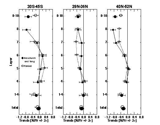
Figure 3.13 Annual ozone trends as a function of altitude deduced from Umkehr data for the following three broad latitude regions: left panel (30°S-45°S) including Perth and Lauder; center panel (29°N-36°N) including New Delhi, Cairo, and Tateno; and right panel (40°N-52°N) including Boulder, Haute Provence, and Belsk. Trends are variance weighted averages within latitude band with 95% confidence intervals. Results are reported for combined layers 1-4, 8-10, and individual layers 4-8 as indicated for two research groups: Reinsel (open circles) and Newchurch and Yang (closed circles).
3.5.1.3. Altitude profiles of annual trends from Umkehr, SAGE I/II, and SBUV/SBUV2
Applying the statistical models to Dobson/Umkehr, SBUV/SBUV2, and SAGE I/II, time series from 1979 (November 1978 for SBUV/SBUV2) to 1996 in various layers and combinations of layers, while accounting for the potential QBO and solar effects, produces the ozone annual trends in Figure 3.14, as percent per year relative to the mean of the period. For Umkehr observations we compute trends for layers 1-4 combined into a single layer, 4-, plotted as a vertical bar from ~1 to 22 km with a triangle, for layers 4-8 individually, and for all layers above seven, 8+, plotted as a vertical bar from ~37 to 54 km. The Umkehr trends in Figure 3.14 are simple averages of the two group analyses presented in Figure 3.13 with root-mean-square 2s error bars. Each individual group average, however, is a variance weighted mean. SAGE I/II trends (diamonds) are computed in natural concentration-versus-altitude coordinates for individual 1-km layers from 15 to 50. However, these are not plotted because they form a smooth curve though the trends computed for 5-km thick layers corresponding to the Umkehr layers.
The SAGE I/II results in this chapter include error estimates attributable to the SAGE I altitude correction (for figures including SAGE I data), the sunrise/sunset trend differences (important above layer 7 and discussed below) and the statistical errors. Trends from SBUV/SBUV2 (circles) are calculated from weekly averages (3 daily values required to create weekly average) and are reported for layers 1-4 combined and for layers 5-9 individually.
In the upper stratosphere (i.e., layer 8), trend estimates range from -0.5 ±0.2%/year for SBUV/SBUV2 to -0.8 ±0.2%/year for SAGE I/II. The Dobson/Umkehr trends for layers 8 and 8+ are both intermediate the SAGE I/II and SBUV/SBUV2 trends and have error bars smaller by a factor of 2. The 2s confidence intervals overlap for the three sensors suggesting that the average layer 8 trend of approximately -0.6 ±0.2%/year is a reasonable estimate of the true atmospheric ozone decline at 40 km.The similarity in the vertical structure of the trends from several instruments provides additional confidence that we are measuring the true atmospheric trend. The largest decline occurs near layer 8 and diminishes to a minimum trend in layer 5 (~25 km) where the trend estimates range from 0.0 ±0.1%/year by Dobson/Umkehr to -0.2±0.2 %/year by SAGE I/II with SBUV/SBUV2 intermediate. These results suggest a trend in layer 5 of -0.1 ±0.1%/year, not significantly different from zero. In layer 9, the SAGE I/II trend is -0.7 ±0.4%/year while the SBUV/SBUV2 estimate is -0.4 ±0.2%/year. The large SAGE I/II error bars at 45-50 km altitude result from uncertainties due to unresolved trend differences between sunrise and sunset observations (described below).
Trends for layers below 5 become more negative in all estimates. The Umkehr trend estimates for layers 4 and 4- are -0.1 ±0.1%/year and -0.4 ±0.2%/year, respectively. The SAGE I/II estimate for layer 4 is -0.5 ±0.4%/year, which is more negative than that deduced from Umkehr measurements. The same is true for the trend in the combined layers 1-4 where the SBUV/SBUV2 trend is -0.7 ±0.3%/year The additional uncertainty in the SAGE I altitude registration at tangent heights below 20-25 km increases the uncertainty in the SAGE I/II trends in layers 3 and 4. The trend of -0.4%/year in Umkehr layer 4- is more consistent with the Dobson total ozone trends of - 0.1 to -0.3%/year calculated by Bojkov et al., (1995) as one would expect from the stringent constraint for Umkehr layers 1-10 to equal the Dobson total column. These results clearly indicate declining ozone in the range of -0.3 ±0.2%/year in layer 4 and of -0.5 ±0.2%/year in stratospheric ozone below approximately 20 km.
Trends calculated from all sensors over the shorter time period of 1979-1989 (corresponding to the lifetime of the Nimbus 7 SBUV) appear in Figure 3.15. The general altitude structure is much the same as calculated for the longer time period. The layer-8 average trend is more negative (-0.8 ±0.3%/year), due to more negative trends from all three sensors. Likewise, layer 9 trends are somewhat more negative. The other layers, however, are not appreciably different. The confidence intervals are generally larger because of the shorter time period.
3.5.1.4. Meridional cross sections of annual trends from SAGE I/II and SBUV/SBUV2
The latitudinal coverage for the SAGE I/II observations extends from 55°S to 55°N. Calculating trends over the period 1979-1996, which comprises the entire SAGE I/II measurement set, results in the altitude-latitude contour plot in Figure 3.16. These trends are based on concentration changes in 1 km altitude layers (the natural coordinates for SAGE). They are referenced to the concentrations at the mid-point of the time series (1987). Typical uncertainties on the annual trends are 0.2 to 0.3%/year (95% confidence limits). A vertical section at 40°-50°N for SAGE I/II is shown in Figure 3.14. In this global view, the maximum ozone trends remain at 40 km (layer 8),
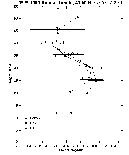
Figure 3.15 Trends as in Figure 3.14 calculated for all sensors over the shorter time period of Nimbus-7 SBUV (1979-1989).
but are larger in the extra-tropics than in the tropics. The minimum trend at 25 km (layer 5) occurs at all latitudes (with slightly positive trends in the tropics). In general, the SAGE I/II trends are significantly different from zero, at the 95% confidence level (approximately ±0.2%/year), at all latitudes outside of the tropics for altitudes above 30 km (layer 6). The trends exhibit remarkable hemispheric symmetry except below 30 km for latitudes poleward of 40°.
The altitude structure of the trends in layers 4-8 from two southern hemisphere Dobson/Umkehr stations at 32°S and 45°S, Perth and Lauder, respectively (Figure 3.13, left panel) agrees with a section through the 32°-45°S area of the SAGE I/II contour plot; however, the SAGE I/II trends in all layers, but especially in layer 6, are somewhat more negative than the Umkehr estimates. SAGE trends computed with SAGE II data only (1984-1996, Figure 3.17), which corresponds more closely to the Perth and Lauder time periods, correspond better in the southern hemisphere and equally well in the northern hemisphere. In the northern sub-tropics, three Umkehr stations are located between 19°N and 24°N, Poona, Mauna Loa, and Aswan, however, because of unresolved data continuity problems at each of these stations they are not used for trend calculations at this time. Three Umkehr stations between 29°N and 36°N, New Delhi, Cairo, and Tateno, exhibit, in Figure 3.13, (centre panel), average trends 0.2 to 0.4%/year less negative than the SAGE I/II estimates in the upper layers, but agree well in the lower layers. The correspondence between the northern mid-latitude Dobson/Umkehr (Figure 3.13, right panel), SAGE I/II, and SBUV/SBUV2 was discussed in the previous section.
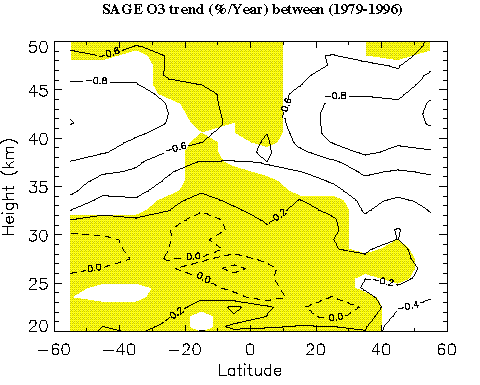
Figure 3.16 Annual ozone trends calculated from SAGE I/II observations from 1979 to 1996 expressed in %/year of the mid-point of the time series (1987). Results are contoured from calculations done in 5° latitude bands and 1 km altitude intervals. Contours differ by 0.2%/year with the dashed contours indicating zero or positive trend. The shaded area indicates where the trends do not differ from zero within 95% confidence limits. The estimate of uncertainty contains terms due to the SAGE I reference height correction and the SAGE II sunrise/sunset trend differences.
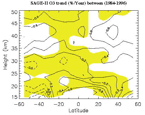
Figure 3.17 Annual ozone trends as in Figure 3.16 for SAGE II only for the time period 1984 to 1996.
The SBUV/SBUV2 trends over November 1978 to October 1994 in percent per year relative to the mean ozone amount from the combined time series at each latitude and layer appear in Figure 3.18. The dark shading indicates the regions in which the derived trend is not significantly different from zero at the 2s level calculated from statistical error bars only; inclusion of the instrument error gives no statistically significant trends between 35°S and 45°N at the 2s level. The lighter shading indicates regions in which the length of the time series during the winter season is compromised as a result of the NOAA-11 orbit drift and where the true annual trend over this time period cannot be calculated. In the northern hemisphere, the data loss is not as extensive as in the southern hemisphere; therefore, the northern high-latitude trends are much more representative of the true annual trends over this time period. On the other hand, data loss in the southern hemisphere high latitudes begins as early as 1990, such that the trends plotted here are actually an average of the spring, summer and autumn trends through 1994 and the winter trend through 1990. The largest ozone losses occur during winter in the profile data through 1990, leading to a substantial bias in the mid to high-latitude trend results in the southern hemisphere over this time period. Comparing the SAGE I/II trends in Figure 3.16 to the SBUV/SBUV2 trends in Figure 3.18 indicates similar small trends of 0.0 to -0.3%/year in layers 5 and 6. In the upper stratosphere, the altitudinal and latitudinal structures of the SAGE I/II and SBUV/SBUV2 trends are similar; however, the SAGE I/II trends are substantially more negative at all latitudes.
In the upper stratosphere (layers 7-9), trends calculated from SBUV alone (1978-1989), as seen in Figure 3.19, exhibit altitude/latitude structure similar to SAGE I/II trends calculated over the same period (Figure 3.20) but the SBUV values remain less negative than the SAGE I/II values. The SBUV trends in layers 8 and above are approximately 0.2%/year less negative than SAGE I/II in both hemispheres. Note that the SBUV latitudinal coverage (±65°) is somewhat greater than the SAGE I/II coverage (±55°). In the lower stratosphere, on the other hand, while the SBUV and SAGE I/II trend structures remain similar, the SBUV trends are more negative than the SAGE I/II estimates by approximately 0.3%/year The SBUV trends are negative or zero throughout the stratosphere, while the SAGE I/II trends are actually positive (e.g., a maximum of +0.4%/year in the tropics) in layer 5. These SAGE I/II trends, however, are statistically insignificant at the 95% confidence level.
Focusing on SAGE trends over three overlapping periods of the 17-year record, we see that trends in the first 11 years (Figure 3.20, from SAGE I/II combined 1979-1989) are more negative in the upper stratosphere and less negative in the middle stratosphere than trends in the last 12 years (Figure 3.17, SAGE II only 1984-1996). The less negative trends seen in the upper stratosphere during the later period result primarily from the influence of relatively small ozone declines in the middle years ~1984-1992 followed by greater declines after 1992 (cf. Figure 3.11). Middle stratospheric trends have become more severe. In fact, the middle stratospheric trends (20-25 km) changed from 0.2%/year increases in the first period to 0.2%/year decreases in the last period. Trends over the 17 year period (Figure 3.16) are intermediate to the estimates for the first 11 years and for the last 12 years.
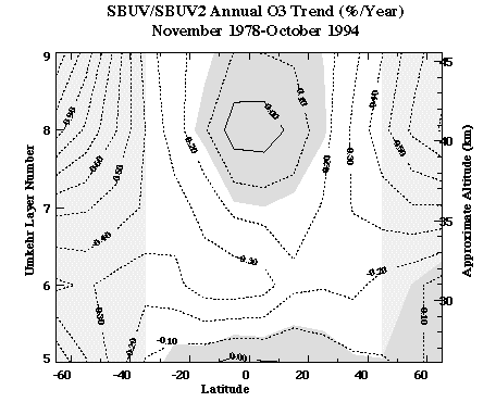
Figure 3.18 Annual SBUV/SBUV2 trend calculated from November 1978 through October 1994 as a function of latitude and Umkehr layer. The trend is in percent per year relative to the mean ozone amount from the combined time series at each latitude and layer. The dark shading indicates the regions in which the derived trend is not significantly different from zero at the 2 s level calculated from statistical error bars only; inclusion of the instrument error renders no statistically significant trends between 35°S and 45°N. The lighter shading indicates regions in which the length of the time series during the winter season is compromised as a result of the NOAA-11 orbit drift.
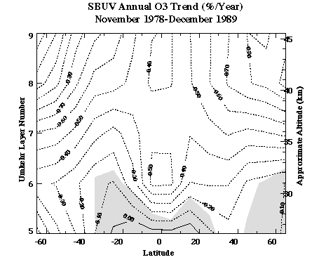
Figure 3.19 The annual SBUV trend calculated from November, 1978 through December, 1989 as a function of latitude and Umkehr layer. The trend is in percent per year relative to the mean ozone amount over this period at each latitude and layer. The contour interval is 0.1 percent per year. The shading indicates the regions in which the derived trend is not significantly different from zero at the 2s level. The trend uncertainty is calculated from the statistical errors only.
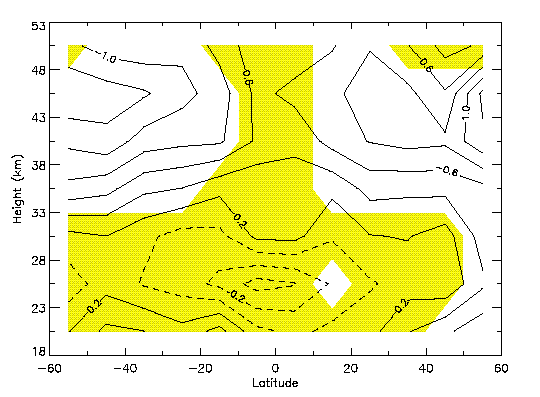
Figure 3.20 Altitude/latitude contours of ozone trends (%/year) calculated from SAGE I/II sunrise and sunset observations (1979-1990) corresponding approximately to the SBUV-only time period shown in Figure 3.19. Shading indicates 95% confidence intervals that include uncertainties due to SAGE I altitude correction, SAGE II sunrise/sunset differences, and statistical uncertainties.
3.5.1.5. Seasonal variation of the SAGE I/II and SBUV/SBUV2 trends
Investigating the trends in layer 8 as a function of latitude and month, we find that both SAGE I/II (Figure 3.21) and SBUV/SBUV2 (Figure 3.22) indicate roughly a factor of 3 seasonal variation in the mid-latitude ozone trends with the most negative trends occurring in the winter (between November and February in the north, June and July in the south). Figure 3.23 shows the SAGE I/II trends as a function of altitude and latitude for individual 3 month periods. The winter maximum trend appears clearly at 40-45 km, with the trend begin strongest during southern hemisphere winter. This seasonal pattern seen in the satellite data is consistent with results from the Dobson/Umkehr analyses, although the seasonal variation of the Umkehr trends is somewhat smaller. SAGE I/II results indicate more seasonal variation in the tropics (0.0 to -0.6%year) than does SBUV/SBUV2 (0.0 to +0.2%/year) and also significantly more negative trends as noted earlier in the annual mean results. The heavy black line surrounding polar night in Figure 3.22 designates the regions with no SBUV2 data because of the drifting NOAA-11 orbit; the thin black line designates the regions with no SBUV2 data after 1992 due to continuing drift of the orbit. In 1994, there are no data in the southern hemisphere outside of the tropics after about April. The structure and magnitudes of the seasonal variation in the southern hemisphere are similar for both SAGE I/II and SBUV/SBUV2, although the area of low trends propagating out of the austral winter extends further equatorward and later in the austral springtime in the SAGE I/II estimates. Note that the SBUV/SBUV2 latitudinal coverage is somewhat larger than that of SAGE I/II as reflected in the latitude-scale differences.
In the high latitudes of the northern hemisphere, the most negative trend in the SAGE I/II data occurs in the late winter while the most negative trend in SBUV/SBUV2 data occurs 2 months earlier in the early winter. Analysing only the NIMBUS-7 SBUV data (i.e., over the shorter period of 1978-1989) in the trend calculation (Figure 3.24) increases the magnitude of the tropical trends markedly to ~-0.3 to -0.6%/year (also seen in Figure 3.26) but has less effect on the seasonal structure at higher latitudes.
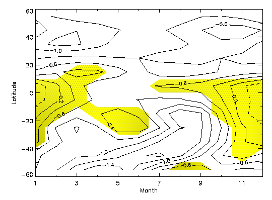
Figure 3.21 Seasonal variation of ozone trends in layer 8 (%/year) calculated from SAGE I/II (1979-1996) for latitudes 55°S to 55°N. Shading indicates 95% confidence intervals that include uncertainties due to the SAGE I altitude correction, SAGE II sunrise/sunset differences, and statistical uncertainties.
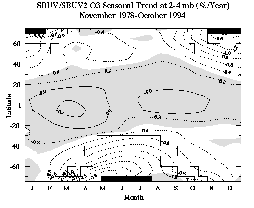
Figure 3.22 Seasonal variation of ozone trends in layer 8 (%/year) calculated from SBUV (version 6) and SBUV2(version 6.1.2) (1978-1994). The shading indicates 95% confidence intervals from statistical errors only. The solid black shading indicates regions of no data due to polar night. The heavy black line surrounding polar night designates the regions with no SBUV2 data because of the drifting NOAA-11 orbit; the thin black line designates the regions with no SBUV2 data after 1992 due to continuing drift of the orbit. In 1994 there are no data in the southern hemisphere outside of the tropics after about April.
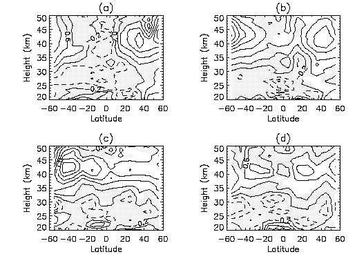
Figure 3.23 SAGE I/II trends as a function of altitude and latitude as in Figure 3.16, but for individual 3 month periods consisting of a) December, January, February; b) March, April, May; c) June, July, August; and d) September, October, November. The statistical model used was of standard form except that the trend term used two seasonal harmonics.
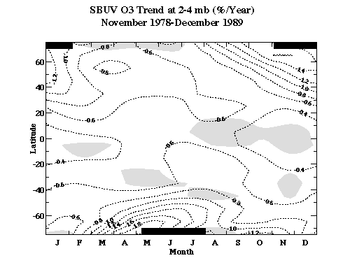
Figure 3.24 Seasonal variation of ozone trends in layer 8 (%/year) calculated from SBUV (version 6) for November 1978 to December 1989 for latitudes 75°S to 75°N. The trend is relative to the seasonal mean (i.e. January mean for the January trend, etc..) ozone amount from the combined layer 8 time series at each 10-degree latitude band. The shading indicates trends that are not significant at the 95% confidence level from statistical errors only. The solid black shading indicates regions of no data due to polar night.
3.5.1.6. Hemispheric symmetry of trend at 40 km (layer 8) from SAGE and SBUV/SBUV2
In order to test the inter-hemispheric symmetry in the ozone trend, we focus on layer 8 and inspect the ozone trends as a function of latitude. Figure 3.25 shows the layer 8 SAGE I/II trends as a function of latitude for the first 11 years (1979-1990, diamonds), the last 12 years (1984-1996, triangles), and all 17 years (1979-1996, solid line). In none of the three periods is an inter-hemispheric difference in the trends evident. The analogous results for SBUV/SBUV2 and only N7 SBUV appear in Figure 3.26. Note that data within ±40°N should not be affected directly by the NOAA-11 drifting orbit. Although minor inter-hemispheric differences exist in the mean results, these differences are statistically insignificant. In layer 9, the N7 SBUV trend asymmetry is ~0.5%/year, but is still not statistically significant due to large inter-annual variability at high latitudes.
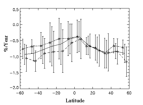
Figure 3.25 SAGE I/II ozone trends at 40 km (layer 8) for latitudes 55°S to 55°N for the following three time periods: The first 11 years (1979-1990, diamonds and dotted line), the last 12 years (1984-1996, triangles and dot-dash line), and all 17 years (1979-1996, no symbols, solid line). Error bars represent 95% confidence intervals that include uncertainties in the SAGE I altitude correction, SAGE II sunrise/sunset differences, and statistical variations.
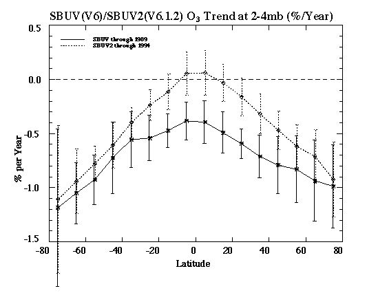
Figure 3.26 SBUV/SBUV2 2-4 hPa (layer 8) ozone trends for latitudes 75°S to 75°N for the period 1979-1994 (dotted line) and for 1979-1989 (solid line). Error bars represent 95% statistical confidence intervals.
3.5.1.7. Sunrise/Sunset differences in SAGE trends
Trends computed exclusively from either sunrise or sunset SAGE observations result in different values above 35 km (layer 7) as seen in Figure 3.27, which shows the difference between sunrise and sunset (sunrise-sunset) trends as functions of altitude and latitude over the period 1979-1996. In layer 8 (40 km), for example the sunrise trends are approximately 0.2-0.4%/year more negative than the sunset trends with some latitudinal variation. In layer 9, differences reach 0.6%/year. Calculating sunrise-sunset differences over only the SAGE II period results in somewhat different latitudinal dependence of the trend differences, but supports the general conclusion that layer 8 indicates 0.3%/year differences and layer 9 experiences 0.6%/year sr/ss differences at some latitudes.
There is some indication that the version 5.96 SAGE II data used for these analyses may exhibit a larger sunrise/sunset discrepancy than the previous version 5.93 SAGE II data; although the version 5.93 trends (Wang et al., 1996) are approximately the same as the version 5.96 trends. There is insufficient independent evidence to prefer one set of occultation measurements to the other (e.g., sunset to sunrise). Additionally, because SAGE I returned sunrise measurements only during the first three months, limiting the SAGE time series to only sunrise or only sunset observations introduces an undesirable sampling bias. We note 1) that the SAGE sunrise-sunset differences are insignificant below layer 8, 2) that the differences in layer 8 are of the same order as the 2s statistical trend uncertainties, and 3) the differences in layer 9 are significantly larger than the trend uncertainties.
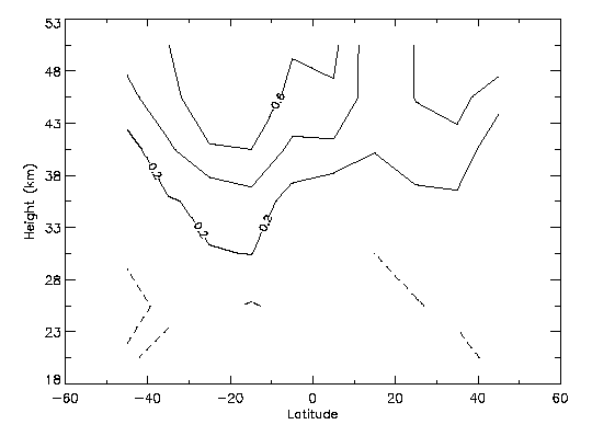
Figure 3.27 Difference between the SAGE I/II ozone trends for sunrise and sunset measurements (%/year) as a function of altitude and latitude over the period 1979-1996.
3.5.2.1. Sondes
Time series
Monthly mean values of ozone near 90 hPa are shown in Figure 3.28a for three stations, using the Harvard selection criteria. The right hand panels show the time series of monthly anomalies (de-seasonalised monthly means). Figure 3.28b shows the time series using the Chicago selection criteria. Measurements are made 2-3 times a week at the European stations and weekly in Canada; at the Japanese stations measurements were made weekly at the beginning and end of the time series, with infrequent data and few summer measurements in between. The frequency of measurements is reflected in the variability in the monthly values (Figure 3.28a). The effect of the stricter Chicago criteria is to introduce more gaps in the time series, and to increase the variance in the monthly anomalies. Time series up to ~1994 for all sonde stations (WOUDC data) are shown in Logan (1994).
An example of the fit of the statistical model to the sonde data is shown for a level near 20 km in Figure 3.29. The top panel shows the monthly mean values, the middle panel shows the fit to the data after removing the seasonal cycle determined by the statistical model, and the bottom panel shows the residuals of the fit for the model.
Uccle, Hohenpeissenberg, and Payerne are the closest together of the sonde locations. There do not appear to be any major biases in ozone values near 90 hPa, except for the early 1970s where values at Hohenpeissenberg and Payerne tend to exceed those at Uccle (Figure 3.30).
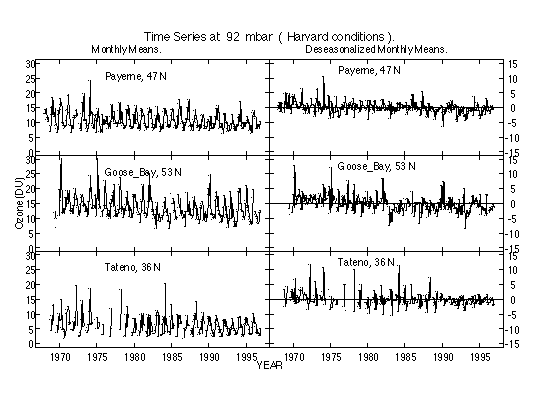
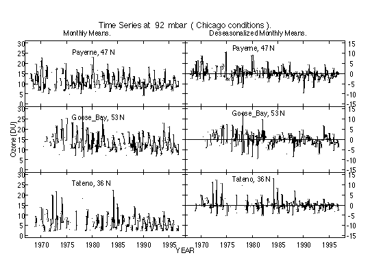
Figure 3.28 Time series of monthly mean values for ozone in DU and deseasonalized monthly means for selected stations. The data selection criteria used by a) the Harvard group and b) the Chicago group, were applied (see text). Values are shown for one of the 33 levels near 90 mbar, and the same relative scale is used for both sets of means.
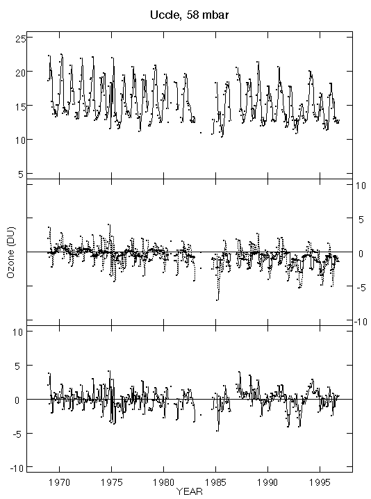
Figure 3.29 Trend analysis of Uccle near 58 mb (~20 km), Harvard results. The top panel shows the monthly mean time series. The middle panel shows the times series with the seasonal component of the model fit removed (dotted line), and the model fit to this (solid line). The lower panel shows the residuals of the complete model fit to the time series.
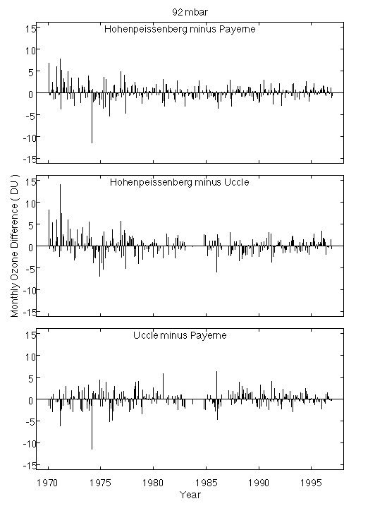
Figure 3.30 Difference of monthly mean values for the three European stations near 90 hPa. The correction factors used by the Harvard group were applied (see text).
Trends for 1970-96
Seasonal trends in the vertical distribution of ozone are shown in Figure 3.31a,b,c for the 11 sonde stations for 1970-96, in percent per decade; the solid lines are those calculated by the Harvard group and the dashed lines those from Chicago. Annual trends are shown in Figure 3.32. The sonde data are expected to be reliable for trend determination up to 27 km, according to the recommendations in Chapter 1. Results are shown for pressure levels centred below 13 hPa, ~29 km, so results for the top level should be considered less reliable than for the other levels.
The seasonal trends determined by the two groups usually agree within ± 3%/decade for most stations, and almost all trends agree within their standard errors in the stratosphere. Agreement is worst for Churchill, with differences of ± 10%/decade in summer and winter; this station suffers from serious data loss with the Chicago data selection criteria. The annual mean trends (Figure 3.32a) agree within 2%/decade in the stratosphere, with the exception of results from Uccle and Payerne.
The annual trends are shown in absolute units (DU/km/decade) in Figure 3.32b. This comparison avoids the problem of the percentage trends being referenced to the mean at different times; pressure was converted to altitude using the U.S. Standard Atmosphere. This figure, like Figure 3.32a, shows that the two groups obtain similar results for the ozone trends except for Payerne and Uccle above 50 hPa. The dashed line shows the absolute trends computed with the Harvard statistical model, but with the data treatment of the Chicago group; their CF criteria, the requirement that the balloon reaches 16 hPa and that there is a measurement of the ozone column, and with the data divided by the correction factor. The results from the two groups are similar at most altitudes at most stations when they use the same data treatment, and the discrepancies at Uccle and Payerne are removed.
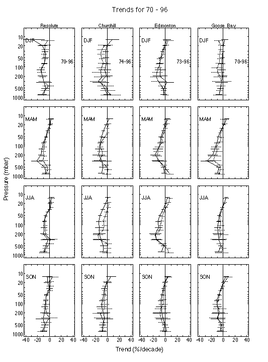
Figure 3.31 a) Seasonal trends in the vertical distribution of ozone for 1970-96 at Resolute (75°N, 95°W), Churchill (59°N, 94°W), Edmonton (53°N, 114°W), and Goose Bay (53°N, 60°W). The Harvard results are shown by the solid line and the Chicago results by the dashed line. Two standard errors for the statistical fit are shown.
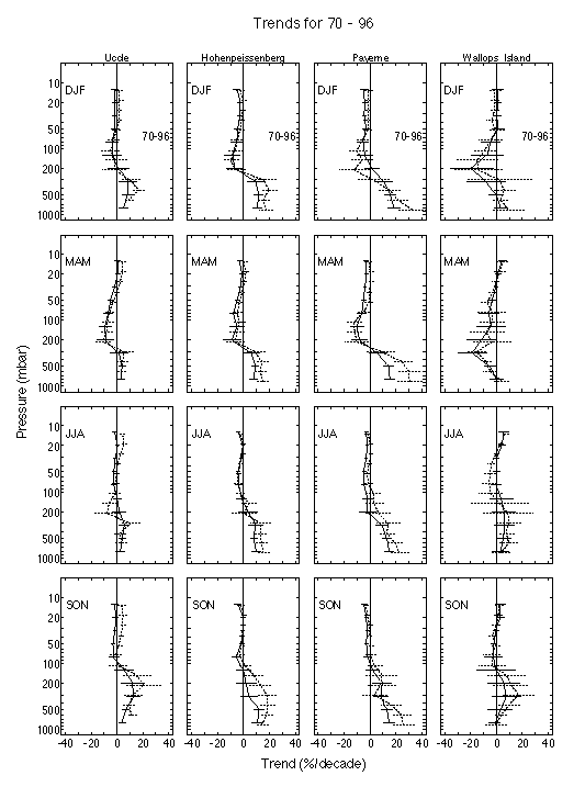
Figure 3.31 b) Seasonal trends in the vertical distribution of ozone for 1970-96 at Uccle (52°N, 4°E), Hohenpeissenberg (48°N, 11°E), Payerne (47°N, 7°E), and Wallops Island (38°N, 75°W). The Harvard results are shown by the solid line and the Chicago results by the dashed line. Two standard errors for the statistical fit are shown.
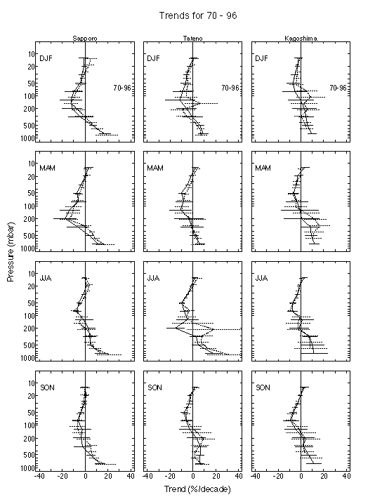
Figure 3.31 c) Seasonal trends in the vertical distribution of ozone for 1970-96 at Sapporo (43°N, 141°E), Tateno (36°N, 140°E), and Kagoshima (32°N, 140°E). The Harvard results are shown by the solid line and the Chicago results by the dashed line. Two standard errors for the statistical fit are shown.
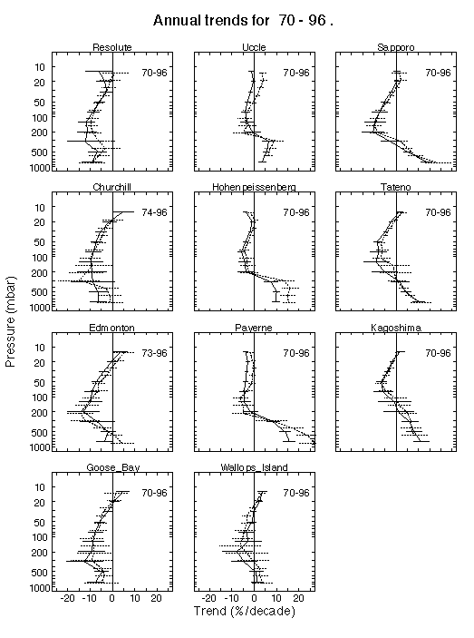
Figure 3.32 a) Annual trends in the vertical distribution of ozone in %/year for 1970-96. The Harvard results are shown by the solid line and the Chicago results by the dashed line. Two standard errors are shown.
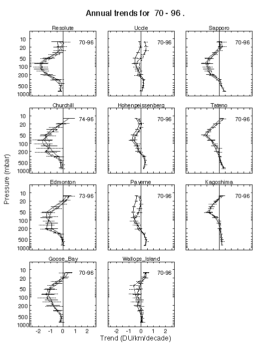
Figure 3.32 b) Annual trends in the vertical distribution of ozone for 1970-96 in DU/km/decade. The Harvard results are shown by the solid line and the Chicago results by the dotted line. Two standard errors are shown. The dashed line shows trends derived with the Harvard model run with the Chicago data treatment (CF criteria, balloon reaching 16 mbar, an ozone column measurement, and the data divided by the CF).
In order to separate the effects of data selection and of dividing by the correction factor, trends were calculated with the Harvard model using the Chicago data selection criteria, with and without removing the scaling to the ozone column. Results are shown in Figure 3.33 (in percent per decade) where the difference between the solid line and the dashed line is caused by data selection criteria, and the difference between the dashed line and the dotted line is caused by dividing by the correction factor.
For stations with no trend in the correction factor, Sapporo and Kagoshima, the different trends in Figure 3.33 are due primarily to the data selection criteria, while for Hohenpeissenberg, where the selection criteria were almost the same, the different trends are due primarily to the trend in the correction factors (see Table 3.2). The effect on trends of dividing by the correction factor is largest (2-3%/decade) for Uccle, Payerne, and Wallops Island, the stations with the largest trend in the correction factors (Table 3.3); for Uccle, the CFs show a distinct jump in 1989 when a new pump correction factor was applied (see Chapter 1). For the remaining stations, the effect of dividing by the correction factor is <2%/decade. Changing the data selection criteria sometimes changes the shape of the trend vertical profile, while dividing by the CF generally shifts the profile to larger or smaller trends depending on the magnitude of the trend in the CF.
Figure 3.34 shows the Harvard and Chicago results as the column trend (in DU per decade) for 250 to 16 hPa; this comparison also avoids the problems of the absolute trends being computed on different layer thicknesses and percentage trends being referenced to the mean at different times. The Harvard standard model generally gives more negative trends for stratospheric ozone than the Chicago model; however, when the Harvard model is run with the data treatment of the Chicago group, there is much less difference compared to the Chicago results (as shown also in Figure 3.32b). The results in Figure 3.32b and 3.34 imply that the treatment of data prior to trend analysis generally has more effect on derived trends than the details of the statistical model. The inclusion of autocorrelation in the Chicago model gives standard errors that appear only slightly larger than those in the Harvard model (see Figure 3.32a for Hohenpeissenberg, where the data selection criteria were almost the same). Once the Chicago data treatment is used in the Harvard model, the remaining causes for differences are the assumption of no trend prior to 1970, the inclusion of autocorrelation in the Chicago model, and the removal of outliers in the Chicago model.
Trends in ozone are largest in the lower stratosphere, with maximum annual trends of -3 to -10%/decade (Figure 3.32). There are statistically significant decreases in ozone at all the stations analysed here. The decrease in ozone is located between about 30 hPa and the tropopause. These results are similar to those shown in Logan (1994), Miller et al. (1995), WMO (1995), and Harris et al. (1997) for analyses of WOUDC data that ended a few years earlier. Bojkov and Fioletov (1997) analysed the sonde data at WOUDC relative to the tropopause height, and found significant decreases only 1-2 km above the tropopause. It is important to note that Bojkov and Fioletov (1997) found that the use of altitude relative to tropopause height as a vertical coordinate significantly reduced the variability in the data set near the tropopause. Analysis with respect to the tropopause was not done in the present study, and should be done in the near future with the reanalysed data sets of this study.
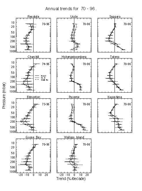
Figure 3.33 Sensitivity of annual trends in the vertical distribution of ozone to data treatment prior to trend analysis. All trends were derived with the Harvard model. The solid line shows results for the Harvard data selection criteria; the dotted line shows results with the Chicago data treatment (their CF criteria, the balloon reaching 16 mbar, and an ozone column measurement, and with the data divided by the CF); the dashed line shows results with the Chicago data selection criteria, but without dividing by the CF.
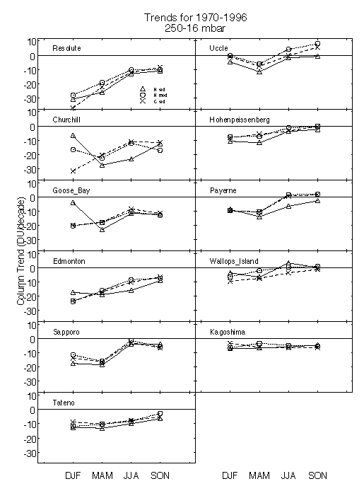
Figure 3.34 Column trend in ozone in DU/decade from 250 to 16 mbar for 1970-96. The triangles are results from the Harvard group, the crosses those from the Chicago group, and the circles are results for the Harvard model, with three conditions of the Chicago group used in data selection, their CF criteria, the balloon reaching 16 mbar, and an ozone column measurement, and with the data divided by the CF.
The annual trends for sonde stations located between 36°N and 59°N are compared in Figure 3.35. The various stations form a reasonably compact band of trends from 125 to 30 hPa, with Wallops Island (Harvard results) and Uccle (Chicago results) showing somewhat less negative trends above 70 hPa than the other stations; the Uccle trend derived by the Chicago group has been influenced by the step function in the correction factors in 1989 (see Chapter 1). The mean trend in ozone for the sonde stations located from 36°N to 59°N is shown in Figure 3.36. Both groups find a mean trend of -7%/decade near 100 hPa. From 80 to 15 hPa, the mean Chicago trend is about 1%/decade less negative than the mean Harvard trend. Referencing the trend to 1970 (Chicago) rather than the mean over 1970-96 (Harvard) may give less negative trends. Both negative and positive trends are seen near 13 hPa, but these results are less reliable than those at 20 hPa and below. The error shown for each layer is the standard error of the annual trends. This error was larger for layers than the root mean square error of the annual trend errors for the individual stations.
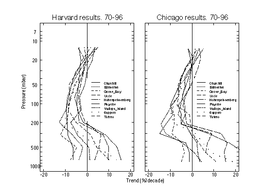
Figure 3.35 Annual trends for individual sonde stations located between 59°N and 36°N, superimposed; a) Harvard results and b) Chicago results.
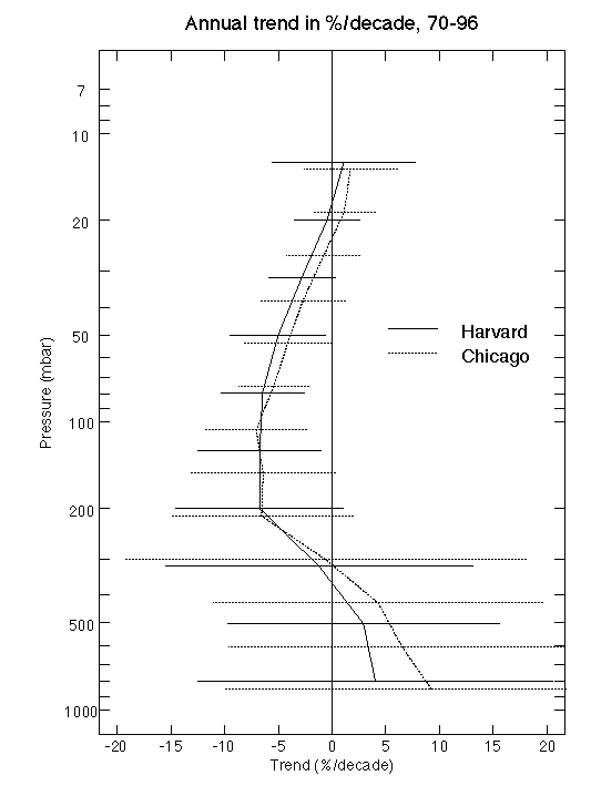
Figure 3.36 Mean annual trend for the sonde stations located between 36°N and 59°N. The solid line shows the Harvard results, the dashed line the Chicago results. Two standard errors are shown; these were calculated as the standard error of the nine trend values at each pressure level.
The ensemble of seasonal trends for 36°-59°N from the Harvard model is shown in Figure 3.37. The closest agreement of trends is found in spring near the ozone maximum, where it is easiest to measure ozone. There is a seasonal variation in the trends that appears to depend on region, as discussed previously by Logan (1994) and Bojkov and Fioletov (1997). Decreases in ozone are largest in spring and winter at the European stations, and in spring and summer at the Canadian stations, as shown in Figure 3.38. There is no significant decrease in ozone below 90 hPa at the European stations in summer and autumn, while the decrease persists in spring to 200 hPa. The decreases in ozone are larger for the Canadian stations than for the European stations, and persist to 200 hPa and below in all seasons. Given the concerns about the Brewer Mast data for the Canadian stations (Chapter 1) these results are subject to some uncertainty. The Japanese stations Sapporo and Tateno also show largest decreases in winter and spring.
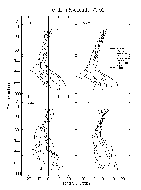
Figure 3.37 Superimposed seasonal mean trends for the sonde stations located between 59°N and 36°N. Harvard results.
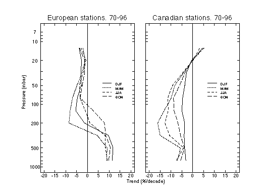
Figure 3.38 Seasonal mean profiles of ozone trend for three European stations, 48-51°N (left) and three Canadian stations, 53-59°N (right). Harvard results.
The composite seasonal behaviour of the eight stations located between 36 and 53°N is shown in Figure 3.39. Both the Harvard and Chicago groups find strong seasonality in the trends from about 300 to 90 hPa, but the seasonal patterns are somewhat different. Both groups find the largest losses in ozone in spring and the smallest losses in autumn in this region. For the Chicago results, the losses in winter are almost as large as in spring, while for the Harvard results, the winter losses are smaller than those in spring.
Which trend results for 1970-96 are likely to be more reliable? Rather than make a judgement, we offer some comments. The major difference between the Harvard and Chicago groups is the choice of data selection prior to trend analysis. The Harvard group use less strict criteria, with the goal of maximising the amount of data of reasonable quality available for analysis. They do not require the soundings to reach a certain height because 95-98% of the soundings at the re-evaluated stations reach 20 hPa. For these stations an ozone column measurement is given whenever a correction factor is given. The Chicago group's criteria are designed to maximise the quality of data used in trend analysis, but the end result is the loss of 70% of the Canadian Brewer-Mast data, and loss of 40-55% of the Uccle, Payerne, Canadian ECC, and Japanese data as shown in Table 3.2. The main cause of data loss is the stricter correction factor criteria, although the other requirements cause significant data loss for the Canadian stations. The effect is that gaps are introduced in the time series, as shown in Figure 3.28. The optimal selection criteria for use of sonde data in trend analysis is clearly a subject of debate. However, both groups find similar results for mean stratospheric trends from 1970 to 1996, even with these differences in analysis.
Another important issue brought out by the differences in the approaches used by the Chicago group and the Harvard group is the scaling to the total column ozone (the correction factors, CFs). Although there are some difficulties with using a uniform scaling for all altitudes, Chapter 1 of this report recommends that the sonde data should be scaled to the ozone column for derivation of the most reliable stratospheric data. The Chicago group selected their data treatment prior to this recommendation and they thus present trends in the uncorrected measurements. For most stations this makes little difference. However, some stations have a trend or a jump in the correction factors and this can make a difference of up to 2-3%/decade as discussed previously by Logan (1985, 1994) and Miller et al. (1995). Given the recommendation of Chapter 1 the trends using correction factors are likely to be more reliable than those without.
Tiao et al. (1990) emphasise the need for accounting for autocorrelation in the data. For the sondes, this appears to have a minor effect on errors derived for trends (e.g., results for Hohenpeissenberg in Figure 3.32), while the treatment of the data prior to deriving trends has a larger impact on trends and associated errors.
Re-evaluation could clearly improve the Canadian data set. About 20% of the soundings fail to reach 20 hPa and many ozone column values are missing (mostly for ECC soundings). Reprocessing of the data using the upper stratospheric profiles from SBUV data to derive ozone columns after 1980 could solve the latter problem (McPeters et al., 1996).
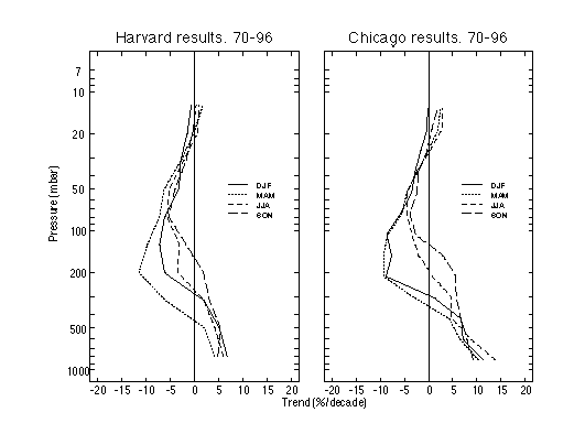
Figure 3.39 Seasonal mean profiles of ozone trend for 8 sonde stations located between 59°N and 36°N. a) Harvard results and b) Chicago results.
Comparison of trends for 1980-96 with 1970-96
Annual trends for individual stations from 1980 to 1996 are shown in Figure 3.40, while the mean trend for 36°-59°N is shown in Figure 3.41 (solid line). In each figure the results are compared to the trend for 1970-96 (dashed line). For about half the stations, the decrease in ozone in the lower stratosphere is larger for the period 1980-96 than for the period 1970-96. The mean trend for the 1980-96 period is more negative by 1-2.5%/decade, with a maximum trend in the lower stratosphere of -10%/decade. The errors in the seasonal trends are larger for the shorter period, because of the short length of the time series. For the Japanese stations the summer trends have extremely large errors because of the paucity of data in much of the 1980s and these contribute to the large errors in the annual trends. The errors in the mean trend for 1980-96 are larger than the errors in the mean trend for 1970-96, because of these factors.
Figure 3.40 includes results for three stations that started operation after the 1970s. Boulder (1980-96) shows significant decreases in ozone from 80 to 20 hPa, while Hilo (1982-96) shows a significant decrease only at 80 hPa; it shows a significant increase at 15 hPa. The data from Lauder (1986-96) do not show any significant trends in the lower stratosphere, but show an increase at 30 hPa. The re-evaluated data were not scaled to the correction factor, and as shown in Table 3.3, there is a small but significant trend in the correction factor.
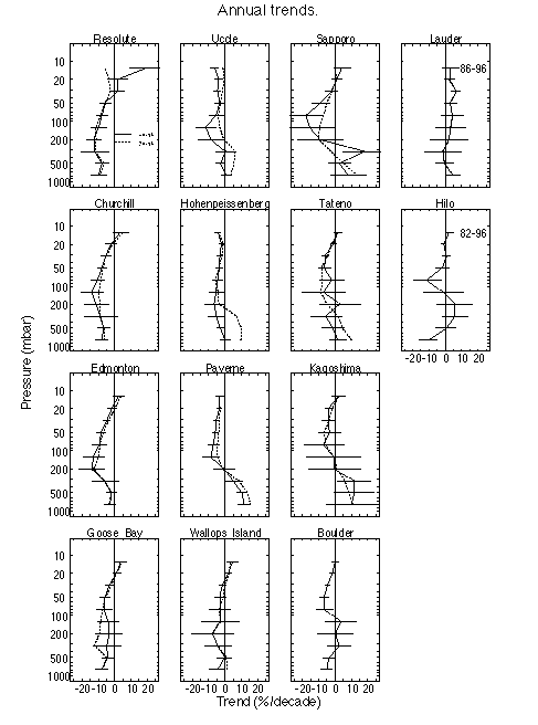
Figure 3.40 Annual trends for 1980-96 (solid lines) compared to trends for 1970-96 (dashed lines) where available. The Lauder trends are for 1986-96, and the Hilo trends for 1982-96. Harvard results.
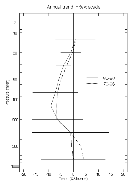
Figure 3.41 Mean annual trend for the sonde stations located between 36°N and 59°N for 1980-96 (solid line) compared to the mean trend for 1970-96 (dotted line). Harvard results. Two standard errors are shown; these were calculated as the standard error of the nine trend values at each pressure level.
Differences in trends derived from WOUDC data and the data re-evaluated for this report
The Chicago group have applied the same trend model to the data re-evaluated for this report and to the data archived at WOUDC prior to re-evaluation for Hohenpeissenberg, Payerne, and the three Japanese stations. Results from the two data sets for each station are fairly similar with the exception of results for Payerne in the troposphere, discussed below. The WOUDC data give slightly more negative trends than the re-evaluated data for the lower stratosphere at Hohenpeissenberg in all seasons. For the Japanese stations and Payerne the results are similar for both data sets from about 80 to 20 hPa.
3.5.2.2. SAGE ozone trends compared with sondes
Figure 3.42a shows time series of monthly mean SAGE ozone values in Dobson units between 20 and 21 km altitude and in the latitude band between 45°N and 50°N. Sunrise and sunset events have been combined in this figure because in the lower stratosphere the differences between sunrise and sunset retrievals are small (much less than those in the upper stratosphere in v5.96). The periods of missing data between the SAGE I and SAGE II observations in 1982-84 and the Pinatubo affected period in 1992-93 are obvious. There is a strong annual cycle in ozone at this location, with highest values in late winter - early spring and smallest values six months later. Figure 3.42b shows the same data after deseasonalisation. These data are relatively compact, except for some wintertime downward spikes associated with years when ozone failed to reach typical high values. These are associated with QBO modulations in mid-latitudes; note the similar patterns at 28°N in Figure 3.9. There is an clear downward trend in the deseasonalised SAGE ozone values. The solid line in Figure 3.42b indicates the statistical model fit to the data and Figure 3.42c shows the residual from this fit.
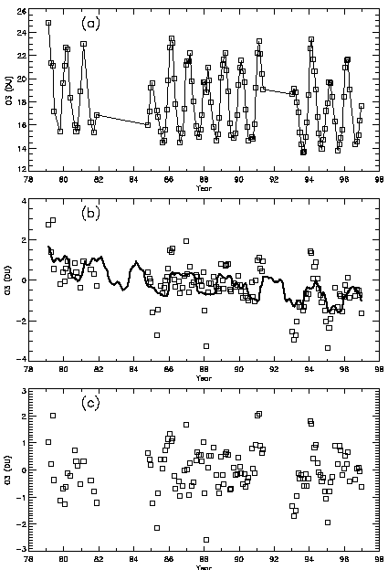
Figure 3.42 a) SAGE I/II monthly mean ozone measurements between 45°N and 50°N integrated from 20 to 21 km altitude in Dobson units. b) The data after deseasonalization. The black line shows the deseasonalized fitted trend model. c) The residuals of the measurements from the trend model.
In Figure 3.16 a meridional cross section of ozone trends in %/year was shown for the combined SAGE I/II data set from 1979-1996. Note these trends are calculated to a lower level of 20 km, as the combined SAGE I/II are not reliable for trend estimates below this altitude (see Chapters 1 and 2). The SAGE I/II trends in the lower stratosphere are significantly different from zero only over latitudes of 40°N to 55°N, where values of order -0.4%/year are found. Figure 3.43a compares the annual mean SAGE I/II trends over 45°N-50°N with averaged sonde results for stations in the latitude band 40°N-53°N. Note that the SAGE data has been extended down to 15 km altitude despite the large uncertainty below 20 km for SAGE I. The agreement with the sondes is good above 20 km. Below 20 km the SAGE I/II trends are different from those derived from sondes but the difference is within the estimated statistical uncertainties (2s). There is little seasonal variation in the SAGE I/II trends in the lower stratosphere (above 20 km), consistent with the lack of seasonality observed in the sondes above 70 hPa (see e.g. Figure 3.39).
Figure 3.43b compares the annual mean SAGE II trends over 45-50°N with averaged sonde results for stations in the latitude band 40°N-53°N for the time period 1984-1996. The agreement is excellent over the entire altitude range from 15 to 27 km. This helps to confirm the use of SAGE II data down to an altitude of 15 km for determination of trends.
Trends between 15 and 20 km derived from the SAGE II data are not, in general, statistically significant (Figure 3.17). The derived trends are negative throughout the northern hemisphere and are strongly negative in the tropics (but not statistically significant because there are large uncertainties in this relatively short data record). In the southern hemisphere mid-latitudes the SAGE II data show a positive trend which is also insignificant, however it is worth noting that the Lauder (45°S) sondes (Figure 3.41) show positive annual trends for the time period 1986-96.
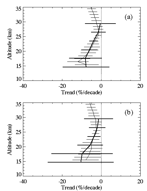
Figure 3.43 Average ozonesonde trends for Uccle, Hohenpeissenberg, Payerne, Edmonton, Goose Bay, Sapporo, and Boulder (40°N-53°N) for the time periods a) 1980-1996 and b) 1984-1996 in %/decade (darker lines). These are compared to a) trends for SAGE I/II and b) trends for SAGE II alone for 45-50°N (lighter lines). The SAGE trends were analyzed at 1 km intervals and the ozonesonde trends have been expressed as a function of altitude using the 1976 standard, mid-latitude atmosphere. 2s error bars are given.
3.5.3.1. Time series
Monthly mean values of ozone near 500 hPa are shown in Figure 3.44 for selected stations; the right hand panels show the monthly anomalies. The data from Goose Bay are for BM sondes prior to August 1980, and ECC sondes thereafter. An intervention term was used in both statistical models to account for the jump, which intercomparisons from the 1970s and early 1980s suggest to be about 15-20%. Difference time series for the three European stations are shown in Figure 3.45 for 500 hPa. There are systematic biases for ozone values in the mid-troposphere in the data reanalysed for this report, as were found in the WOUDC data for Hohenpeissenberg and Payerne (Logan, 1994). Even with the re-evaluated data, ozone values at Hohenpeissenberg are systematically higher than those at Payerne from about 1978 to 1990, while there is less bias in the 1970s. Values at Uccle are higher than those at Payerne and at Hohenpeissenberg up to about 1986. These biases result in different trends for the three stations. The data used here for Payerne are provisional, as discussed in Chapter 1, and are likely to be revised further. There are particular concerns about the consistency of the tropospheric data for Payerne in the 1980s.
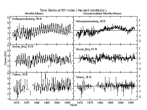
Figure 3.44 Time series of monthly mean values for ozone in DU and deseasonalized monthly means for selected stations. The selection criteria used by the Harvard group were applied (see text). Values are shown for a level near 500 mbar. The same relative scale in used for both the monthly means and the deseasonalized monthly means.
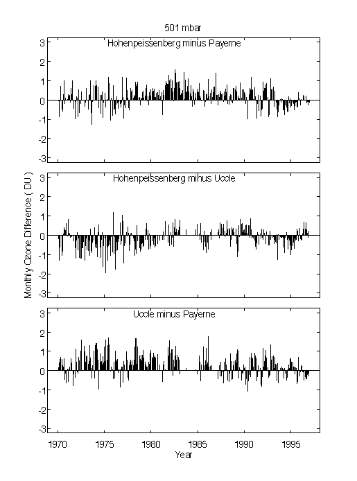
Figure 3.45 Difference of monthly mean values near 500 mbar for the three European stations. The selection criteria used by the Harvard group were applied (see text).
3.5.3.2. Trends for 1970-96
The most obvious feature of the tropospheric trends shown in Figures 3.31a,b,c and 3.32 is that there are significant spatial variations in the magnitude and sign of the trends, with decreases, or no significant trend at the Canadian stations and increases at the European and Japanese stations. The increases over Europe and at Kagoshima are significant up to 300 hPa, while the increases at Sapporo and Tateno are significant only at 500 hPa and below. There is not a significant seasonal variation in the tropospheric trends (e.g., Figures 3.31, 3.38, 3.39). Compared to the Harvard results, the Chicago trends are less negative for the Canadian stations, more positive for the European stations and Wallops Island, and about the same for the Japanese stations. The Harvard group find increases of 5-15%/decade for the European stations, while the Chicago group find increases of 6-25%/decade. Part of this difference is caused by referencing the trend to the beginning rather than the middle of the record. For example, at the lowest layer at Hohenpeissenberg, the Chicago trend is 16%/decade, while the Harvard trend is 10%/decade; however, the Chicago trend would be only 12%/decade, if referenced to the same value as the Harvard trend. Similarly, the Chicago trend in the lowest layer at Wallops Island would be reduced from about 3%/decade to 1.2%/decade (similar to the Harvard trend) if referenced to the same value as the Harvard trend. The results from the two groups for Payerne and Hohenpeissenberg for the absolute trend (Figure 3.32b) and for the tropospheric column trend are in closer agreement than the results for the percentage profile trends (Figure 3.46, solid and dashed lines), another indication that the reference point makes an important difference to the results in %/decade. The Harvard and Chicago results for the column trends for 1000-250 hPa are similar for most stations, and using the Chicago data treatment with the Harvard model generally improves the agreement.
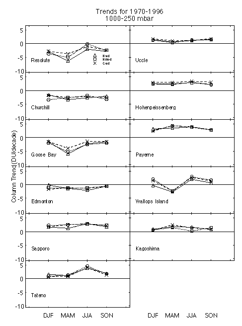
Figure 3.46 Column trend in ozone in DU/decade from the lowest layer to 250 mbar. The triangles are results from the Harvard group, the crosses those from the Chicago group, and the circles are results for the Harvard model, with three conditions of the Chicago group used in data selection, their CF criteria, the balloon reaching 16 mbar, and an ozone column measurement, and with the data divided by the CF.
The ozone increases in Europe and Japan from the Harvard group for 1970-96 are somewhat less than those reported for 1970-91 for the WOUDC data (Akimoto et al., 1993; Logan, 1994). This is caused by the relatively flat values of ozone in the last few years (see Figure 3.44). Bojkov and Fioletov (1997) find the increase at Hohenpeissenberg to be significant only 1 km below the tropopause. By comparing data for the first 5 years from the Canadian stations with data for 1987-91, Logan (1994) concluded that there was no evidence for a long-term increase in ozone at the Canadian stations, given the different responses of BM and ECC sondes. This result contradicted the earlier analysis of Wang et al. (1993) who reported an increase of 10%/decade for all the Canadian stations. Using an intervention in the statistical model to treat the change in sonde type, the Harvard group finds long-term decreases for all the Canadian stations (-2 to -9%/decade), while the Chicago group finds similar decreases or no significant trend at the same stations. Oltmans et al. (1998) report an increase of 15%/decade for Hohenpeissenberg for 1968-95, using a least squares fit to annual mean values. They also find no trend at Wallops Island and results very similar to those in Figure 3.32 for Tateno. They analysed only these three stations, selected for the consistency of their record, and used the data at WOUDC.
3.5.3.3. Trends for 1980-96
There is a major change in many of the trends for the period 1980-96 compared to 1970-96 (Figure 3.40). For the European stations, only Payerne shows an increase, of ~10%/decade, while Uccle shows no change in ozone, and Hohenpeissenberg has a slight negative trend in the middle troposphere. There are concerns about the consistency of the tropospheric data for Payerne in the 1980s. Tateno also shows no change in ozone, while Sapporo and Kagoshima have increases of 5-15%/decade, not all of which are significant. There are many gaps in the data record for these two stations in the early 1980s, particularly for summer. These gaps give rise to large errors in the summer trends, which contribute to the large errors in the annual trends. The Canadian stations show decreases of -2 to -8%/decade, and these are more reliable than the results for 1970-96 since ECC sondes were used for the whole record. Previous analyses of the Canadian ECC data also showed decreases (Logan, 1994; Tarasick et al., 1995; Oltmans et al., 1998). Oltmans et al. (1998) find no significant trend in ozone for Hohenpeissenberg, Boulder, Wallops Island, Tateno, and Hilo for 1979-95 in the middle troposphere, in agreement with the results in Figure 3.40. The increases in ozone apparent in the late 1960s and 1970s appear to have levelled off at several of the sonde stations, and also at remote surface sites, as discussed by Logan (1994) and by Oltmans et al. (1998). The mean trend for the stations from 59°-36°N is zero, 4%/decade less than the mean trend for 1970-96 (Figure 3.41). Mean trends for both periods are insignificant. The concept of a mean trend is less appropriate for the troposphere than for the stratosphere. The locations of the sonde stations in remote regions of Canada, and more polluted regions of Europe and Asia, may lead to different regional influences on tropospheric ozone from trends in emissions of NOx and from changes in stratospheric input of ozone (e.g., Logan, 1994).
3.5.3.4. Differences in trends derived from WOUDC data and reanalysed data
The Chicago group finds similar tropospheric trends using the reanalysed data and WOUDC data for Hohenpeissenberg, Sapporo, Tateno and Kagoshima. The results for the two data sets are dramatically different for Payerne, with much larger tropospheric increases derived for the WOUDC data than for the data used here (Figure 3.47). The history of problems with the Payerne data is documented in Chapter 1, and the WOUDC data contained erroneously high values for ozone in early 1990s. The data used here are considered more reliable, but further revisions are expected in the Payerne data. Miller et al. (1995) used the WOUDC data and reported anomalously high trends.
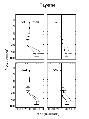
Figure 3.47 Comparison of seasonal trends for (i) sonde data re-evaluated for this study (solid lines) and (ii) for sonde data archived at WOUDC (dotted lines), for Payerne. The same data selection criteria and trend model was applied to both sets of data. Chicago results.
In this section the column ozone trends derived from TOMS are compared to the integrated ozone profile trends derived from SAGE I/II and ozonesonde data, in order to determine consistency between these independent results. TOMS data are the combined version 7 Nimbus 7 - Meteor 3 data, spanning January 1979-December 1994 (as reported in McPeters et al., 1996). SAGE I/II trends are calculated over January 1979-December 1996 (with no data available during January 1982-September 1984), and ozonesonde results span January 1980-December 1996. We consider near-global comparisons between TOMS and SAGE I/II, and northern hemisphere mid-latitude results for TOMS, SAGE I/II and ozonesondes in subsequent sections.
3.5.4.1. Comparison of TOMS and SAGE I/II trends
SAGE I/II data are reliable for trend analyses over the altitude range 20-55 km, so the column integral of SAGE data is calculated over these levels. For reference, the seasonal climatology of column ozone over 20-55 km from SAGE data is shown in Figure 3.48b, together with the TOMS climatology (Figure 3.48a), and their difference (i.e. the inferred column ozone below 20 km, Figure 3.48c). Note the lack of SAGE sampling in polar regions in Figure 3.48b, so that direct comparisons are restricted to ~60°N-S. In the extra-tropics, a large fraction of the ozone column lies below 20 km. The column above 20 km shows relatively weak seasonal or latitudinal variations, whereas large latitudinal gradients and strong seasonality is seen in the lower stratosphere (below 20 km).
Figure 3.49a shows the TOMS column ozone trends as a function of latitude and season. This is similar to the results shown in McPeters et al., (1996), except the units here are DU/decade to facilitate the comparisons below. Instrumental uncertainty is not included in the significance estimates in Figure 3.49. The TOMS data show negative trends in northern hemisphere mid-latitudes during late winter-spring; the March-April values of ~ -24 DU/decade in Figure 3.49a correspond to percentage changes of ~ -6%/decade. There are smaller magnitude mid-latitude trends in the southern hemisphere (~ -10 DU/decade). No significant TOMS trends are found in the tropics.
Trends in column ozone over 20-55 km derived from SAGE I/II data are shown in Figure 3.49b as a function of latitude and season. Significant negative trends of order -4 to -8 DU/decade are observed in northern hemisphere mid-latitudes throughout most of the year (with a maximum in April-May near 50°N), and in southern hemisphere mid-latitudes during all seasons except summer. Significant trends are not observed near the equator. Comparison with the much larger TOMS trends in northern hemisphere spring mid-latitudes suggests that a majority of these column trends occur at altitudes below 20 km.
Figure 3.49c shows trends in the difference between the TOMS column ozone data and the SAGE I/II data integrated from 20 to 55 km. This corresponds to trends in the column below 20 km (i.e. the difference between Figures 3.49a,b). Negative trends are observed polewards of 40° in each hemisphere; there are relative maxima in northern hemisphere spring (discussed above) and in southern hemisphere summer (although the former are not statistically significant). Small positive trends are seen in the tropics (~ 30°N-S); because of the small background (seasonal) values in the tropics below 20 km (see Figure 3.48c), these latter trends equate to a relatively high percentage (~5-10%/decade).
3.5.4.2. Comparison of ozonesonde, SAGE I/II, and TOMS trends
The majority of long-term ozonesonde records are in northern hemisphere mid-latitudes, so we focus here on comparisons with ozonesonde trends over the latitude range 40°-53°N. The ozonesonde results are an average of seven stations (Boulder (40°N), Sapporo (43°N), Payerne (47°N), Hohenpeissenberg (48°N), Uccle (51°N), Edmonton (53°N), and Goose Bay (53°N), while for the satellite data we use the zonal means over 40°-52°N. Figure 3.50a,b,c,d shows vertical profiles of the ozonesonde and SAGE I/II trends for each season, expressed in units of DU/km/decade for each of four seasons. The uncertainties for the seasonal trends in Figure 3.50 are relatively large (much larger than the annual means in Figure 3.43); the sonde uncertainties in DJF are larger than those in other seasons because of large geographical variability between the different stations. Also shown in Figure 3.50 are the column integrals, separated according to 0-20 km and 20-30 km levels for the sondes, sums above 20 km for SAGE, and the total column trends from TOMS. Comparison of the sondes and SAGE I/II trends shows reasonable agreement over altitudes of 20-27 km with SAGE slightly less negative (as shown also in Figure 3.43). The column integrals of the sondes show good agreement with TOMS trends, in particular showing a maximum in the winter (DJF) and spring (MAM). A substantial fraction of the ozonesonde trends occur below the 20 km level for all months except autumn. In spring the trends below 20 km are particularly large, accounting for approximately two-thirds of the total column. Both the magnitude and seasonality in the ozonesonde trends below 20 km are consistent with the differences between TOMS and SAGE I/II shown in Figure 3.49 above (at least for the latitude band 40°-53°N).
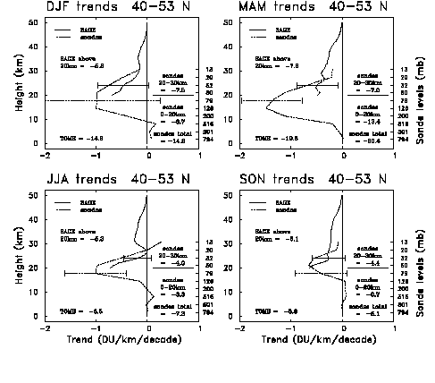
Figure 3.50 Altitude profiles of ozone trends over 40°N-53°N for; a) December, January, February; b) March, April, May; c) June, July, August; d) September, October, November, showing SAGE I/II and ozonesonde results. The column integrals for the SAGE data (above 20 km) and ozonesonde data (over 0-20 and 20-30 km separately) are indicated, along with TOMS total column trend results.
3.5.4.3. Comparison of sonde, Dobson, and TOMS trends at the sonde locations
The sonde trends in DU were integrated from the lowest layer to the layer with its top boundary near 16 hPa, omitting trends derived from the less reliable data obtained near the top of the soundings. These are compared to trends derived from the Dobson (or Brewer) column data that were obtained on the same day as the sonde measurements. (The column data were sometimes unavailable for the Canadian ECC sondes). The trends in the column data were derived using the Harvard trend model used for sonde data, omitting measurements on days that did not meet the CF criteria for sondes used by the Harvard group. Figure 3.51 compares the column trends and the integrated sonde trends, the latter for both the Harvard and Chicago results. The Harvard results are in somewhat better agreement with the column trends for the European stations, while the Chicago results underestimate the column loss more than the Harvard results. For the Canadian and Japanese stations, there is no systematic bias between the Harvard and Chicago results with respect to the Dobson trends. If there is ozone loss above 16 hPa, the integrated sonde trends should be less negative than the Dobson trends, which is sometimes but not always the case.
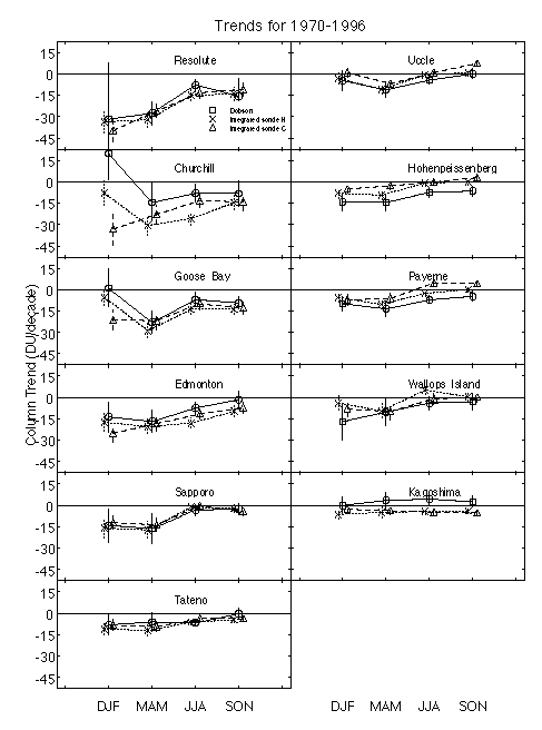
Figure 3.51 Comparison of column trends for ozone for 1970-96. The circles show the trend in the Dobson overhead ozone column measured on the same days as the sondes used in the Harvard analysis, computed with the Harvard trend model. The crosses show the integrated sonde trend up to 16 mbar, computed with the Harvard trend model, and the triangles show the integrated sonde trend up to 16 mbar computed by the Chicago group. Two standard errors are shown. The errors for the sonde data are only approximate, as they do not account for any correlation between ozone at one layer and the next, and the Chicago errors are smaller in part because they are for 12 layers rather than 9. The three results for each season are offset for clarity.
Figure 3.52 shows the column trends derived from TOMS by Hollandsworth for November 1978 to October 1994, compared to the integrated sonde trends and Dobson column trends for 1980-1996. The three trends agree within their standard errors, but the agreement is best for the European stations, Boulder and Tateno. The agreement is worst for Churchill and Resolute in the winter, when Dobson data are sparse. The TOMS data confirm that the percent decrease in ozone (not shown) is largest in spring and summer at the Canadian stations (except Goose Bay with largest losses in autumn) and in winter and spring at the European stations. Figure 3.52 is not an ideal comparison of the ground-based and TOMS ozone columns, since it uses the ground based column data only on the days when there was an ozone sounding.
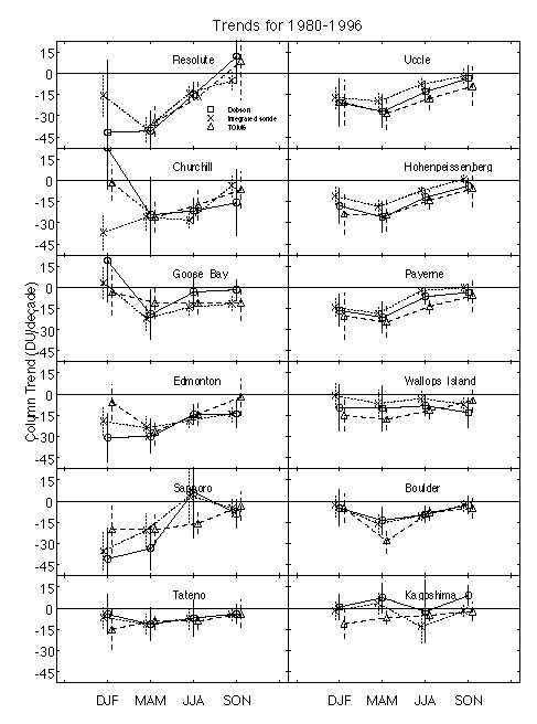
Figure 3.52 Comparison of column trends for ozone for 1980-96. Circles and crosses show the column and integrated sonde trends defined as in Figure 3.51. The triangles show the trend in TOMS data for November 1978 to October 1994, computed by Hollandsworth. The three results for each season are offset for clarity.
3.5.4.4. Summary
A large fraction of the ozone column in middle-high latitudes (and most of the seasonal variation) occurs below 20 km. Trends in the column ozone above 20 km derived from SAGE I/II data show negative trends over mid-latitudes of both hemispheres, but the values are substantially less than TOMS in high latitudes (particularly for northern hemisphere spring and southern hemisphere summer). Trends derived from ozonesonde data over 40°N-53°N show that large fractions of the column trends occur below 20 km. Both the magnitude and seasonal variation of the ozonesonde trends are consistent with TOMS data, and the ozonesonde results below 20 km are in agreement with the observed TOMS - SAGE I/II trend differences.
![]()