 |
Stratospheric Processes And their Role in Climate
|
||||||||
| Home | Initiatives | Organisation | Publications | Meetings | Acronyms and Abbreviations | Useful Links |
![]()
|
Stratospheric Processes And their Role in Climate
|
||||||||
| Home | Initiatives | Organisation | Publications | Meetings | Acronyms and Abbreviations | Useful Links |
![]()
Most of the questions raised in the introduction to this chapter have been addressed. The upper altitude limit of SAGE II data for use in determining trends is on the order of 50 km based on noise in SAGE II and intercomparisons with HALOE. The lower limit is less determined, most likely because of low altitude atmospheric variability and aerosol effects on both in SAGE II measurements and the data used for comparisons. In most instances, the differences in trends between SAGE II and correlative data start to increase below about 20 km and they become much more variable thus limiting the lower altitude at which derived trends can be validated. This is not to say that SAGE trends are invalid in this range, only that for the measurements systems used in the intercomparisons, a less definitive statement can be made about trend validity. The smallest long-term changes that can be verified over the 20 km to 50 km altitude interval are in the range of 0.3%year-1 when viewed as a function of latitude. Between 20 km and 40 km, the Dobson/Umkehr measurements constrain SAGE I/II drifts in a narrow latitude band in the northern mid-latitudes to 0.2±0.2%year-1 and in the Southern mid-latitudes to 0.3±0.3%year-1 at the 95% confidence level. Globally averaged SAGE I/II trends over this altitude range are constrained by both ground-based and satellite measurements to be valid to a level on the order of 0.2%year-1 at the 95% confidence level. It appears that the best agreement in trends occurs for SAGE II comparisons with other satellite data; although the Dobson/Umkehr comparisons provide equally good constraints in the northern and southern mid-latitudes. There is some evidence, even though it is statistically insignificant, that there is a slight drift in SAGE II of about 0.4%year-1 when compared to MLS and HALOE. The most important screening consideration is to eliminate SAGE II data in the lower stratosphere contaminated by Mt. Pinatubo aerosol absorption. Table 2-2 (see Section 2.3.1) provides a time and altitude screening guide. There are some obvious sunrise/sunset differences in the SAGE II data that are important only above approximately 45 km as discussed below. Finally, the question of SAGE I/SAGE II data offset was addressed and it was determined that the main offset is due to altitude registration between the two sets of measurements. The correction developed by Wang et al.(1996) is recommended as a satisfactory correction and was used in this study.
SAGE II absolute values agree with sondes in the altitude region between 20 km and 28 km to within a few % but below 20 km, SAGE II values start to increase relative to the sondes and reach values which are 15% to 20% larger at 15 km. The low altitude differences are latitudinally dependent which could indicate a problem with using the data for trend calculations.
The regression slopes for time series of coincident differences between SAGE I/II and other measurements for individual stations or latitudes is summarised quantitatively in Table 2-13 and graphically in Figure 2-50. Values range from £ 0.3± 0.15%year-1 to ~0.5± 0.7%year-1 (sondes, lidar, Umkehr, HALOE) for altitudes between 20 km and 35 km and £ 0.5± 0.5%year-1 to ~1 ± 1%year-1 for altitudes between 35 km and 50 km. Only two systems (sondes and lidar) provide useful trend comparison data for the altitude range between 15 km and 20 km. Trends of matched pair (i.e. sonde minus SAGE II) differences at individual stations show significant variability, ranging up to 3%year-1 at 15 km for Lauder; however, best agreement was obtained when the matched pair differences from the eight sonde stations used in Chapter 3 were combined into a single time series to calculate the regression slope of the differences. No statistically significant differences were obtained for the combined time series, but the mean difference was ~0.25% ± 0.3-0.4%year-1 in this lower stratosphere range above ~15 km altitude. This suggests that there is a fair degree of noise in the differences at individual stations due either to atmospheric variability, sampling, or instrumental effects; but it also suggests that SAGE II trends in the lower stratosphere are accurate to the 0.25%year-1 level.
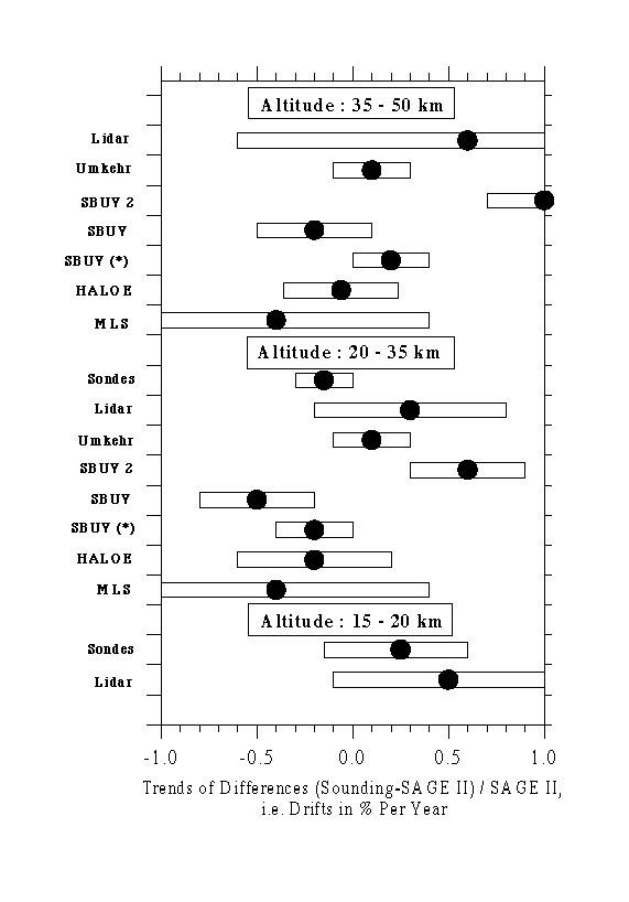
Figure 2.50 Trends of differences (i.e. drifts) between ozone measurements made by various ozone profiling instruments and SAGE II in % per year [(Sounding - SAGE II)/SAGE II]. Trends with ozonesondes are for the eight northern mid-latitude sounding stations used in Chapter 3 covering 36°N to 56°N. Umkehr differences are averages for eight Northern and Southern Hemisphere stations. Lidar differences are averages for the three stations with the longest records and number of coincidences exceeding 100 (Hohenpeissenberg, OHP and TMF). Trends of satellite differences (SBUV, SBUV2, HALOE and MLS) are presented as global means. The average differences are indicated by the dots and the bars represent the 95% confidence intervals of the drift estimations.
While no statistically significant drift was found between SAGE and the ozonesondes, differences in the absolute values of the measured ozone were found. The SAGE II absolute values agree with sondes in the altitude region between 20 km and 28 km to within a few %, but below 20 km SAGE II values start to increase relative to the sondes and reach values which are 15% to 20% larger at 15 km. The low altitude differences are latitudinally dependent which could indicate a problem with using the data for global trend calculations.
|
|
|
|
|
| Ozonesondes (1984-1996) for NML |
0.7 to 3-4 0.25± 0.35(1) |
± 0.7 for Z£ 28 km -0.15± .0.15 |
|
| Lidar (various time periods) |
(1 to 2 )± 1 | 0.1±0.4 to 0.5±0.7 | (0.2 to 2)±0.7 |
|
Umkehr for NML (1984-1996) |
-0.1±0.2 to 0.2±0.2 | -0.1±0.2 to 0.3±0.2 | |
| Umkehr for NML (1984-1996) Column Amount |
Layers 2 to 10 0.1±0.2 |
||
| SBUV 2 (1989-1994) Global Mean |
1±1.5 Layers 5-7 0.6 ±0.3 |
1±1.5 Layer 8, 9 1.0 ±0.3 |
|
|
SBUV (1984-1989) Global Mean |
(0.5 to 1) ±0.6 Layers 5-7 -0.5 ±0.3 |
(0.5 to 1.5) ±0.6 Layer 8 ,9 -0.2 ±0.3 |
|
| SBUV - SAGE I&II (1979-1989) |
-0.2±0.2 for Z>30 km | 0.2±0.2 | |
|
HALOE (1991-1996)
Global Mean |
(-0.4 to +0.4) ±0.5 , [except 15°N, and 55°S: ~(1-2 )±0.5]
-0.2 ±0.4 (-0.4 ± 0.3 @ 30 km) |
(-0.5 to + 0.5) ±0.5, [except 55°S: ~(1-2)±0.5]
-0.06 ±0.3 |
|
|
MLS (1991-1996) HALOE |
-0.4 ± 0.8
-0.3 ± 0.8 |
-0.4 ± 0.8
-0.4 ± 0.8 |
|
(1)Below 16 km slopes of the differences become
much larger and reach
0.85%year-1 at 15.5 km
Average of global means: Z>20-35 km: -0.3±
0.5%year-1, Z>35-50 km: -0.2
± 0.5%year-1
Table 2-13: Trends of differences (Sounding-SAGE II)/SAGE II, i.e. possible drifts (%year-1), Uncertainties are 95% confidence intervals
Examination of latitudinally averaged trends of differences (i.e. global trends) shows negative drifts of -0.06% to -0.4% ± ~0.6%year-1 for SBUV, HALOE, and MLS comparisons (SAGE II trend larger than other measurements). These differences, although statistically insignificant, give a slight indication of a SAGE II drift with time (SAGE II trend is larger). SBUV2 differences with SAGE II are of opposite sign to SBUV, HALOE and MLS, but this is most likely due to algorithm effects brought on by a drifting orbit as discussed in Chapter 1. Globally averaged analyses of the longest satellite time series - SBUV compared with the composite time series of SAGE I/II (1979 to 1989) - shows agreement to (-0.2% to 0.2%) ± 0.2%year-1 in the altitude region between 20 km and 50 km.
While some evidence exists to suggest that SAGE I and SAGE II overlapping measurements are inconsistent (e.g. Hohenpeissenberg, Payerne and Uccle comparisons), the results are not statistically significant. It is recalled that SAGE I data have been corrected for a systematic reference height error of approximately 300 m (latitude dependent). The uncertainty in this correction for each latitude is approximately 100m. Below 20 km altitude a simple upward shift of the SAGE I profiles (as has been assumed for this report) may be incorrect because of the large Rayleigh scattering contribution to the 0.6 nm extinction at these altitudes. An inversion of the SAGE I data to correct the altitude registration problem would be preferable. Data can be used for trends with caution below 20 km, but more intercomparisons are needed to draw firm conclusions. This is consistent with the Chapter 1 statement on this issue.
SAGE II data show a difference of ~10% between sunrise and sunset ozone values at 1 hPa (SS higher). This is unphysical and is much greater than the difference between HALOE sunrise/sunset values of approximately 2%. There is no reason to prefer SAGE II sunrise measurement over sunset (or vice versa). We recommend combining SR and SS for doing trend studies, but because the reason for the SR/SS differences is unknown, the error bars for derived trends will be increased. This effect is important only for altitudes above 45 km.
The results of the coordinate mapping (CM) study showed general agreement with the conventional analyses, which rely on measurement space and time coincidence. Near 25 km, both the conventional and CM technique shows statistically significant regression slopes of differences in the 40-50°S (1-1.5%year-1) and 60-70°S (~0.5%year-1) regions. Differences between the two satellite measurements also appear in the CM analysis near 40-50°N in the same altitude range with the CM technique indicating a marginally significant positive drift of SAGE relative to HALOE of ~1 ± 0.75%year-1. At higher altitudes, CM results show insignificant drifts of less than 0.5%year-1 in all regions except the polar summer latitudes. Differences in this region, which cannot be directly compared to conventional results, indicate statistically significant trends of differences, with SAGE ozone trends being larger relative to HALOE.
Comparisons of ozonesondes in the stratosphere with other ozone profiling techniques show consistent results with agreement of about ± (3-5)% at altitudes between the tropopause and 28 km. The precision of the different sonde types is better than ± 3%. Above 28 km the results are not consistent due to instrumental uncertainties (e.g. pump corrections and sensing solution changes) and caution must be used, at least for the non-ECC types of sondes, when applying the data for long-term trend determinations.
A dearth of sonde validation studies exist for the troposphere and because of the small number of comparisons, only estimates about the reliability of the sonde data records below the tropopause can be made. In general, ECC-sondes provide much more consistent results than the other two types of sondes. The precision of the ECC-sonde is better than ± (5-10)% and shows a small positive bias of about 3%. Brewer Mast and KC79-sondes are less precise (± (10-20)%), but there are no indications of any bias larger than ± 5%. Key issues of uncertainty are the background correction and the use of the total ozone normalisation factor.
The main reasons for observed differences between different sonde results from sounding stations using the same type of ozone sonde are believed to be due to differences in the preparation and correction procedures applied at the different launch sites. Although much progress has been made to improve the quality and homogeneity of the ozonesonde data since the last WMO Scientific Assessment of Stratospheric Ozone in 1994, there is still an urgent need to investigate and intercompare the instrumental performance of the different sonde types as well as a need to revise and agree on procedures for preparation and data processing.
![]()