 |
Stratospheric Processes And their Role in Climate
|
||||||||
| Home | Initiatives | Organisation | Publications | Meetings | Acronyms and Abbreviations | Useful Links |
![]()
|
Stratospheric Processes And their Role in Climate
|
||||||||
| Home | Initiatives | Organisation | Publications | Meetings | Acronyms and Abbreviations | Useful Links |
![]()
Based on comparisons between MLS and SAGE II ozone data, Cunnold et al. (1996a) demonstrated that, following the eruption of Mt. Pinatubo, SAGE II ozone values were being systematically over-estimated because of a failure to correctly account for the removal of the aerosol contribution at 600 nm. Steele and Turco (1997) further demonstrated that the aerosol contribution at 600 nm in the SAGE II observations was being incorrectly simulated especially in the absence of major volcanic eruptions. The SAGE II retrieval team reached a similar conclusion at approximately the same time and modifications were made to the algorithm by incorporating a more realistic simulation of typical aerosol size distributions and the wavelength dependence of the aerosol extinction contribution. SAGE II version 5.96 resulted from these changes (together with other changes which had only minor effects on ozone but which increased sunrise/sunset ozone differences somewhat in the upper stratosphere). The effect of the algorithm modification was primarily a significant change in ozone retrievals below 20 km altitude (see Figure 2.2). The changes were fairly systematic except in 1991-1994 (e.g. see Figure 2.2c).
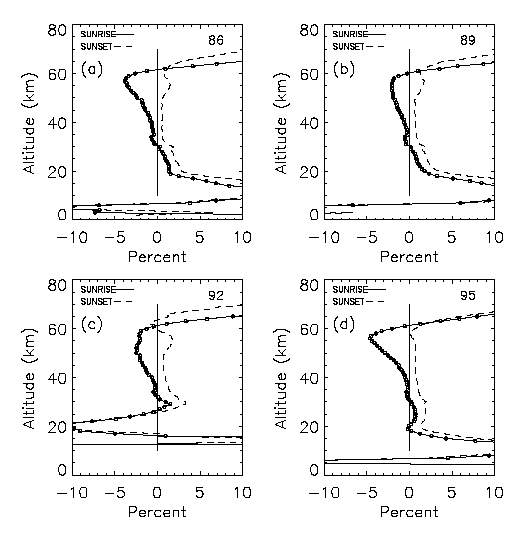
Figure 2.2 The ratios of all SAGE II retrieved ozone concentrations during (a) 1986, (b) 1989, (c) 1992 and (d) 1995 between algorithm versions 5.96 and 5.93 for sunrise (full lines) and sunsets (dashed lines) and expressed as (V.96 - V.93)/V.93. Note the separation of the two lines above 40 km altitude, the significant differences in the retrievals below 20 km altitude, and the unique behaviour of the differences below 30 km altitude in 1992 (caused by a new treatment of aerosol effects).
Figure 2.3 shows a time series of the SAGE II (v 5.96) results at 45°S and 18.5 km altitude and Figure 2.4a shows the differences between SAGE II and MLS ozone values at 68 hPa at mid-latitudes as a function of time. Both figures indicate that the SAGE II ozone measurements were anomalously variable in 1992 and 1993 and that the SAGE II values were larger relative to the MLS values than in other years. It is concluded that the improvements associated with the version 5.96 SAGE II retrieval algorithm have not totally removed the aerosol contamination of the ozone signal during times when the aerosol extinction was large.
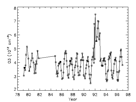
Figure 2.3 A time series of zonal monthly mean SAGE ozone measurements at 18.5 km altitude, 45oS. Note the anomalous ozone values from mid-1991 until mid-1993 which were caused by aerosol interference effects on the SAGE retrieval algorithm.
In the trend studies it is therefore recommended that periods with high aerosol loading be filtered out of the SAGE II ozone time series. Several filters have been considered for this purpose. These include the elimination of specific time periods at different locations (see Table 2.2), eliminating values based on the aerosol extinction value, or eliminating values based on the magnitude of the SAGE II error bars for ozone. Figure 2.4(b) and (c) shows that error bars greater than 20% were typical when SAGE II ozone values were high relative to MLS values, whereas error bars less than approximately 12% were typical of background conditions after 1994 when SAGE-MLS differences were relatively systematic at the 10% level. This is because, in SAGE version 5.96 retrievals, an uncertainty arising from the inability to fully separate ozone and aerosol contributions has been added to the SAGE error bars for ozone. This uncertainty is approximately proportional to the aerosol loading. It is evident from the SAGE/MLS differences in Figure 2.4a that SAGE error bars still do not completely reflect the aerosol interference effect since the SAGE/MLS % differences exceed the SAGE error bars when the error bar greater than 25%. Nevertheless, from Figure 2.4a and 2.4b, it is seen that the SAGE-MLS difference stabilised when the SAGE error bar decreased to approximately 12%. A SAGE II error bar of less than 12% has been used to filter data in a number of the comparisons presented in this Chapter. However at the 100 hPa level, SAGE II error bars are often larger than 12% throughout the entire time series because of the small and highly variable ozone concentrations there. The temporal filter shown in Table 2.2 is preferred because it eliminates the few remaining measurements of unknown quality in 1991-1993. In addition, in order to eliminate a few spurious data points, all SAGE II ozone values with an error bar exceeding 50% have been eliminated.
Figure 2.4 (a) Comparisons between SAGE II and coincident MLS ozone measurements binned in 35oN-55oN and 35oS-55oS and by month at 68 hPa. Note the large SAGE II values prior to 1993. (b) Average, reported SAGE II error bars as a function of time for the data in (a). (c) The percentage differences between SAGE II and MLS ozone observations, for data in (a), plotted as a function of the SAGE II mean error bars.
|
|
|
|
|
|
14 hPa |
|
|
|
|
21 hPa |
|
|
|
|
32 hPa |
|
|
|
|
46 hPa |
|
|
|
|
68 hPa |
|
|
|
|
100 hPa |
|
|
|
Table 2.2: Time filtering criteria for SAGE data. It is recommended that SAGE II ozone data from the time of the Mt Pinatubo eruption in June 1991 until the times indicated in the table be eliminated from trend calculations.
2.3.2.1. SAGE I/SBUV Comparisons
Figure 2.5 shows mean percentage differences between coincident SAGE I and SBUV observations where the SAGE I observations have been integrated over the SBUV (or equivalently Umkehr) layers using the NWS pressure/ temperature/geopotential height profiles which were supplied with each SAGE profile. Recalling that each SAGE I profile has received an altitude adjustment as a function of latitude, it is likely that the anomalous differences in layers 6-9 at 70°S reflect systematic differences between SAGE I and SBUV observations. This might in part be due to a small SBUV error at large solar zenith angle. At other latitudes, the differences between SAGE I and SBUV in layers 6-9 fairly systematically equal a few percent with the altitudinal and latitudinal structure of the differences being consistent with the structure of the differences between SAGE II and SBUV observations (see Figure 2.6). There were almost no sunrise observations for SAGE I (only approximately 3 months) and the SAGE II sunrise/sunset differences are addressed in Section 2.4.8. In layers 4 and 5 SAGE/SBUV differences vary strongly with latitude. This reflects the lack of vertical resolution of the SBUV observations below approximately 20 hPa and inadequacies of the SBUV a priori profiles.
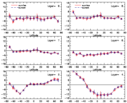
Figure 2.5 The differences between the altitude adjusted SAGE I observations and coincident SBUV measurements expressed as percentage of the SBUV values. SAGE sunsets and sunrises have been treated separately and the data have been placed in 10° wide latitude bins. The SAGE data have been placed on pressure levels using the NWS temperature profiles and then summed over Umkehr layers for compatibility with the reported SBUV values. The error bars are twice the standard errors of the differences.
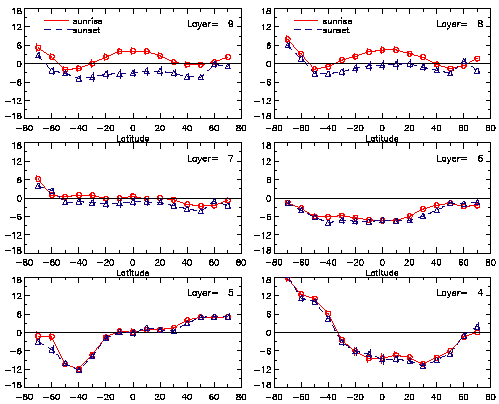
Figure 2.6 As for Figure 2.5, but for the SAGE II measurements from October 1984 to June 1990.
A second comparison between SAGE I and coincident SBUV profiles over almost 3 years of SAGE I operation was obtained by calculating the amplitude of the 12 month ozone periodicities. These annual amplitudes, expressed as a percentage of the layer mean values at each latitude, are shown in Figure 2.7 (a) and (b). The similarity in structure of the two plots is excellent, considering that the uncertainties in the estimates are approximately 3%. It is also noteworthy that SAGE II observations show a similar structure in the annual cycle (Figure 2.7 (c)). Both the vertical structure in the plots and the hemispheric differences are similar. On the basis of these comparisons, we suggest that there are no obvious deficiencies in the SAGE I observations in the middle and upper stratosphere.
SAGE I utilised fewer wavelengths than SAGE II and it is therefore more difficult to remove the effects of aerosols from the 600 nm channel than for SAGE II. Fortunately the stratospheric aerosol loading during the SAGE I period was unusually low. The SAGE II measurements are a little more accurate than those for SAGE I which could also impact the retrievals at very high and very low altitudes. Of most concern, however, for the SAGE I results below 20 km altitude is that there have been no new retrievals of the SAGE I profiles using the empirically-derived SAGE I reference height errors. It is therefore believed, as noted earlier, that SAGE I data below 20 km possesses significant uncertainties.
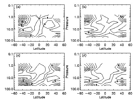
Figure 2.7 A comparison of the Umkehr layer mean amplitudes of the annual cycle in ozone (expressed as percentages of the annual mean values) from (a) SAGE I, (b) coincident SBUV, (c) SAGE II and (d) coincident SBUV2 observations.
2.3.2.2 SAGE I/Sonde Comparisons
We compare SAGE I, SAGE II, and ozonesonde measurements in this subsection relying on the assumption that the sondes can be used as a transfer standard between SAGE I and SAGE II. Good agreement would imply that SAGE I ozone measurements can be used in combination with SAGE II results in the calculation of ozone trends. Comparisons were performed only at mid to high latitudes because of the vanishingly small number of SAGE I/sonde coincidences at lower latitudes. SAGE I ozone densities less than 5x10¹¹ or greater than 1x1013 cm-3 were eliminated in doing the comparisons. Also, since the SAGE I data set is just three years in length, no attempt was made to compare SAGE I/sonde time dependent differences. Instead, the percent differences with three sonde stations (Hohenpeissenberg, Payerne, and Uccle) are presented as a function of altitude for both SAGE I and SAGE II.
Comparisons of SAGE I (asterisks), SAGE II (diamonds), and ozonesonde data are shown in Figure 2.8. The data sets were combined because of the small number of coincidences between the sondes and SAGE I. The comparisons above 27 km are not deemed significant due to potential ozonesonde errors. In the 27 to 25 km region, the SAGE I/sonde and SAGE II/sonde differences are outside the 2 sem of the differences, a fact that must be taken into account when combining the data sets. Below 25 km, the uncertainties overlap at all altitudes except 16.5 km, even though substantial differences exist in the comparisons at certain altitudes. For example, at 17.5 km, even though the bars overlap, the SAGE I/sonde difference is 14% whereas the SAGE II/sonde difference is about 7%; at 16.5 km, the differences are 5 and 10%. At 15.5 km the SAGE II difference is about 9% and the SAGE I difference is about 2%. Because the differences are quite large at many altitudes, caution should be exercised in using the combined SAGE I/SAGE II data sets in calculating long-term ozone trends at mid- to high latitudes.
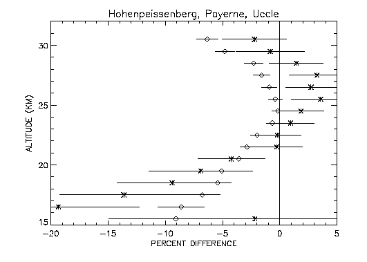
Figure 2.8 Percent difference in measured ozone between sonde and SAGE I (asterisks) and sonde and SAGE II (diamonds) as a function of altitude for the combined coincidences at Hohenpeissenberg, Uccle, and Payerne.
![]()