 |
Stratospheric Processes And their Role in Climate
|
||||||||
| Home | Initiatives | Organisation | Publications | Meetings | Acronyms and Abbreviations | Useful Links |
![]()
|
Stratospheric Processes And their Role in Climate
|
||||||||
| Home | Initiatives | Organisation | Publications | Meetings | Acronyms and Abbreviations | Useful Links |
![]()
The lidar (LIght Detection And Ranging) is a remote sensing instrument similar in principle to the radar but operating in the optical range. Depending on the desired measurement, lidar systems use various light-matter interactions such as Rayleigh, Mie and Raman scattering or fluorescence. Measurements of atmospheric ozone, temperature or aerosol are based on the first 3 processes. Generally, a lidar measurement consists in sending into the atmosphere a laser beam ; a small part of this laser radiation is scattered back to the ground, where it is collected by a telescope, detected by a photomultiplier tube and analysed by an electronic acquisition system. Range resolved measurements can be obtained using pulsed lasers. In order to measure the ozone vertical distribution, the Differential Absorption Laser technique (DIAL) is used. This technique requires the simultaneous emission of two laser beams characterised by a different ozone absorption cross-section.
A lidar system includes basically one or several laser sources with optical devices to reduce the divergence of the beam, a telescope which collects the light scattered back by the atmosphere, an optical analysing system with detectors such as photomultipliers to detect the optical signal, and an electronic acquisition system (see Figure 1.24). The analysing systems used to digitise the electronic signal provided by the photomultipliers include photon counting and/or transient analysers. In the case of the DIAL systems characterised by the emission of two laser wavelengths, the optical receiving system comprises spectral analysing optics, such as interference filters or spectrometers.
To monitor atmospheric ozone with the DIAL technique, the choice of the laser wavelengths depends on the altitude range of the measurement (Mégie et al., 1985). The spectral range is chosen first in the ultraviolet where the ozone absorption is more efficient, but the selected wavelengths differ according to whether the measurement is made in the troposphere or in the stratosphere - in the troposphere, the ozone number density is small so the laser wavelengths must correspond to a strong UV absorption, while for stratospheric measurements, the objective is to reach the stratosphere and to detect the high ozone concentrations there (Browell, 1989, Papayannis et al., 1990). Furthermore, in the higher stratosphere, one has to consider the simultaneous decrease of the ozone number density and the atmospheric number density which provides the backscatter radiation. This leads to the need for powerful laser sources in order to reach the high altitude ranges. The absorbed wavelength should not be strongly absorbed in order to reach the stratosphere. Most teams working on this subject use XeCl eximer laser sources, which emit directly in the UV at 308 nm (Uchino et al., 1978) and are very powerful (100 W are commonly reached with the present systems). For the non-absorbed wavelength, different techniques are used, mainly the generation of a wavelength at 353 nm corresponding to the first Stokes radiation by stimulated Raman effect in a cell filled with hydrogen (McDermid et al., 1990, Werner et al., 1983, Swaart et al., 1994), the use of the third harmonic of a Nd:Yag laser (355 nm) (Godin et al., 1989, Uchino et al., 1991), or the use of a XeF laser which provides a wavelength at 351 nm (McGee et al., 1991, Nakane et al., 1994).
At the present time, about 12 stratospheric ozone lidar systems are in operation throughout the world for long-term monitoring. The lidar measurements used in this report are summarised in Table 2.4 of chapter 2. They correspond mainly to the longest ozone lidar time series obtained in the latitude range covered by the SAGE II instrument. Most of these measurements are presently performed in the frame of the NDSC (Network for the Detection of the Stratospheric Changes) which was set up in the beginning of the 1990s for ground based long-term monitoring and satellite validation purposes.
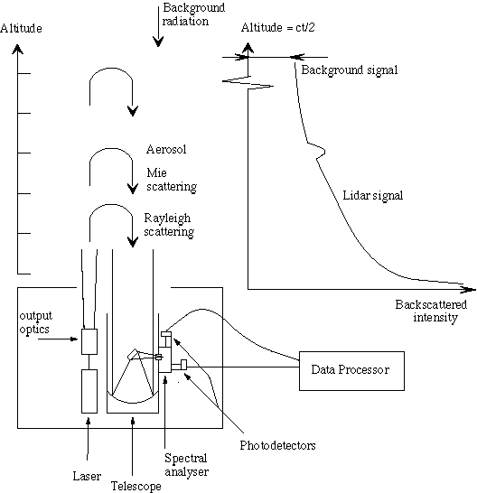
Figure 1.24. Schematic view of the principle of a lidar system
The lidar signals cover a very high dynamic range corresponding to several orders of magnitude, which is not handled by the electronic acquisition systems. This requires the use of simultaneous photon counting and analogue acquisition for the low and the high signals or the separation of the optical signal in two parts (90% and 10%), corresponding to the high and the low altitudes respectively. For reasons of simplicity in terms of electronic acquisition, the latter solution is the most commonly used. Depending on the power and the repetition rate of the laser, an ozone measurement lasts typically several hours, leading to a spatial resolution of the order of 100 km, depending on the atmospheric conditions. The vertical resolution ranges from several hundred meters in the lower range to several kilometres above 40 km. This evaluation is detailed in the following sections. Finally, one main caveat of the lidar measurements is the requirement of clear sky meteorological conditions - laser radiation is rapidly absorbed by clouds and only cirrus can be tolerated for accurate stratospheric measurements.
Assuming a monochromatic laser impulsion at wavelength l, the received optical power corresponding to the light backscattering at altitude z, is given by (Measure, 1984) :
![]() (1.6.1)
(1.6.1)
where K(l) is an instrument constant involving the telescope surface area, the emitted power, the optical efficiency of the receiving system and a geometrical factor depending on the alignment of the laser and the telescope axis, b(l,z) is the atmospheric backscatter coefficient and t(l,z) is the atmospheric optical depth. t(l,z) depends on the following parameters :
![]() (1.6.2)
(1.6.2)
where a(l,z) is the atmospheric extinction coefficient, ![]() the ozone absorption cross-section,
the ozone absorption cross-section, ![]() the ozone number density to be measured and the term
the ozone number density to be measured and the term ![]() corresponds to the extinction by other absorbers.
corresponds to the extinction by other absorbers.
Applying this formula to the second wavelength and taking into account the background signal, one derives the ozone number density from the received lidar signals:
![]() (1.6.3)
(1.6.3)
where Pbi is the background signal and:
![]() (1.6.4)
(1.6.4)
The laser wavelengths are chosen so that the term ![]() represents less than 10% of the measurement. The derivation of
the ozone number density from the laser signals shows thus that
the DIAL technique is a self-calibrated technique which doesn't
need the evaluation of instrumental constants.
represents less than 10% of the measurement. The derivation of
the ozone number density from the laser signals shows thus that
the DIAL technique is a self-calibrated technique which doesn't
need the evaluation of instrumental constants.
Main steps of the algorithm
The DIAL algorithm follows basically the theoretical derivation of the ozone number density from the lidar signals. The main steps are the following :
The precision of a DIAL measurement is defined by the statistical error due to the random character of the detection process which follows basically the Poisson statistics (Measures, 1984). The accuracy of the measurement depends on the approximations made in deriving the ozone number density from the received signals. It depends also on the linearity of the lidar signals.
According to the Poisson statistics, the statistical error on ozone is given by the following formula :
![]() (1.6.5)
(1.6.5)
where DZ is the initial range resolution of the acquisition system, Pi,j corresponds to the lidar signal at wavelength i from altitude Zj, cj are the coefficients of the low pass derivative filter used to differentiate the signals, Ni is the number of laser shots at wavelength li and Pbi is the background radiation at wavelength li. The final statistical error e s on the measurement is the result of a compromise depending on the experimental system characteristics, the duration of the signal acquisition and the vertical resolution according to the following relation :
![]() (1.6.6)
(1.6.6)
where A is the telescope receiving area, DZ the final range resolution, P0 the emitted power and Ta the acquisition time. Due to the rapid decrease of the signal to noise ratio in the high stratosphere, it is necessary to degrade the vertical resolution of the measurement in order to limit the statistical error at this altitude range, to reasonable values. Most teams choose low pass filters with varying number of points as a function of the altitude. The DIAL stratospheric ozone lidar profiles are thus generally characterised by a vertical resolution varying from several hundred meters in the lower stratosphere, to several kilometres around 50 km (see Figure 1.25 for an example of ozone lidar vertical resolution profile).
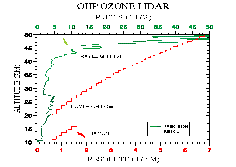
Figure 1.25. Precision and vertical resolution profile of an ozone measurement in the case of the OHP lidar instrument. Both the precision and the vertical resolution profile depend on the experimental configuration. The precision can vary from one measurement to the other.
The accuracy of the measurement depends on the term ![]() (see equation 1.6.4) which corresponds to less than 10% of the
value derived directly from the slope of the signals but still
has to be corrected using ancillary measurements. It depends also
on the accuracy of the ozone absorption cross-sections and on
the approximation concerning the monochromaticity of the laser
radiations. These error sources are summarised in Table 1.9 which
indicates the residual error on the measurement after correction
(Godin, 1987).
(see equation 1.6.4) which corresponds to less than 10% of the
value derived directly from the slope of the signals but still
has to be corrected using ancillary measurements. It depends also
on the accuracy of the ozone absorption cross-sections and on
the approximation concerning the monochromaticity of the laser
radiations. These error sources are summarised in Table 1.9 which
indicates the residual error on the measurement after correction
(Godin, 1987).
|
|
|
| Ozone absorption cross-section | |
|
- Absolute value (Bass&Paur) |
|
|
- Temperature sensitivity |
|
| Laser line width | |
| Rayleigh extinction | |
| Other absorbers | |
|
- SO2 - normal conditions - after major volcanic eruption |
negligible 1% |
|
- NO2 |
|
| Aerosol backscatter and extinction | |
|
- Volcanic conditions : - correction using ancillary size distribution measurements - use of Raman channel |
30% < 5% |
|
- background |
|
Table 1.9
For the temperature sensitivity of the ozone absorption cross-sections and the Rayleigh extinction term, the correction requires daily pressure-temperature profiles provided by nearby radiosondes and assimilated satellite data or temperature lidar measurement in the upper altitude range. For the error related to the nitric oxide, an annual average profile is generally used. Since the residual error is directly related to the precision of the parameters and ancillary measurements used in the ozone formulation, it can be considered as random.
Error due to volcanic aerosol and use of Raman scattering
In the presence of volcanic aerosol, the DIAL ozone profile is locally perturbed at the altitude of the aerosol cloud. The corresponding error is expressed in equation 1.6.7:
![]() (1.6.7)
(1.6.7)
It can be separated in two components related to the backscatter and extinction effects respectively. The main contribution to the error is due to the backscatter effect, directly linked to the aerosol since the corresponding molecular contribution, proportional to the atmospheric number density for both wavelengths, cancels out.
ea can be determined if one evaluates the spectral behaviour of the aerosol backscatter and extinction coefficients from assumed aerosol size distribution. But the Angström coefficient of the backscatter coefficient is highly non-linear and residual errors can exceed 100% in the case of very strong aerosol loading (Godin et al., 1994, Steinbrecht and Carswell, 1995).
Another more efficient method to handle this problem is to detect the lidar signals corresponding to the first stokes vibrational Raman scattering by molecular nitrogen of the emitted wavelengths (McGee et al., 1993). The advantage of this method is to suppress the aerosol contribution to the backscatter component of the lidar equation but its drawback is a loss of accuracy due to the much smaller Raman scattering efficiency. In order to compensate this effect, one has to degrade the vertical resolution of the corresponding measurement following the compromise expressed in equation 1.6.6 (see Figure 1.26 for an example of ozone Rayleigh and Raman profiles). The residual error related to the aerosol extinction can be evaluated with aerosol models based on experimental measurements. It has been shown experimentally (McGee et al., 1994) to be less than 5% even in the case of heavy aerosol loading.
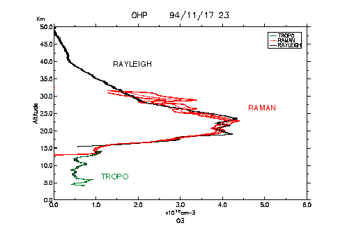
Figure 1.26. Example of Rayleigh and Raman ozone lidar profiles. These measurements are compared to a tropospheric lidar profile obtained on the same site with a different lidar instrument.
Instrumental error sources
As mentioned previously several experimental artefacts can alter the linearity of the lidar signals and thus introduce biases in the retrieved ozone concentration. The main problems encountered with the DIAL technique are :
In order to obtain a correct ozone measurement, the axis of the laser beams and the receiving telescope must be aligned. Any error in the alignment procedure will effect the slope of the signals and then the ozone retrieved density.
This effect is due to the high intensities originating from the scattering of the laser light in the first few kilometres. It results in a slowly decreasing signal which is superposed on the background light (McDermid et al., 1990). This problem is perceptible at the high altitude ranges, where the signal to noise ratio is low. It can induce high or low biased ozone concentrations depending on which wavelength is the most affected by the signal induced noise. In order to avoid the signal induced noise effect, it is necessary to include mechanical choppers in the experimental set-up, since electronic obscuration of the photomultiplier tubes is not sufficient to tackle this problem.
At low altitude ranges, the photon counting systems cannot handle the high intensities received by the photomultiplier tubes. Most lidar teams use several electronic channels for one wavelength, which allows to preserve the linearity of the signal by switching from one channel to the other. In that respect, the use of Raman channels is very useful, since their low intensity allow to check the linearity of the Rayleigh channels in the lower altitude range.
As mentioned earlier, it is necessary in the DIAL technique to use a low pass filter in order to take into account the rapid decrease of the signal-to-noise ratio in the higher altitude range. The usual method is to use a filter whose number of points varies with altitude, which defines a final vertical range resolution profile. Above 40 km or more, depending on the power of the laser sources, the use of a high number of points introduces a bias in the ozone retrieved quantity. Recent simulations performed in the frame of the NDSC by various lidar teams allowed to quantify this bias for a given configuration. This bias can reach 10% at 45 km (Godin, 1996).
The DIAL method is a powerful technique for the measurement of the ozone vertical distribution in the atmosphere. It is particularly suited for trend studies since it is self-calibrated. The DIAL measurements are characterised by a good precision and good vertical resolution especially in the low stratosphere. Typical values are vertical resolutions ranging from ~0.5 km at 20 km and 4 to 7 km at 50 km and precision ranging from ~1% at 20 km to 10%-50% at 50 km depending on the systems and the weather conditions. Finally, the lidar measurements require clear skies, so this has to be taken into account in the choice of the site for long-term studies.
The various error sources which could have an effect on trend
studies are summarised in Table 1.10. As mentioned previously,
the error sources related to the term ![]() of equation 1.6.4 are corrected in the ozone algorithm so their
trend effect should be of second order. More generally, the errors
which could affect the trends should be dominated by instrumental
artefacts such as the eventual presence of signal induced noise,
detector saturation or alignment problems. But these artefacts
are very difficult to quantify since they depend completely on
the instrumental configuration and on the operating procedure.
This is why the lidar set-ups designed for long-term operation
and operating in the frame of the NDSC are required to fulfil
several requirements in order to maintain the linearity of the
lidar signals in the whole altitude range of the measurement.
Among these requirements, one can cite in particular :
of equation 1.6.4 are corrected in the ozone algorithm so their
trend effect should be of second order. More generally, the errors
which could affect the trends should be dominated by instrumental
artefacts such as the eventual presence of signal induced noise,
detector saturation or alignment problems. But these artefacts
are very difficult to quantify since they depend completely on
the instrumental configuration and on the operating procedure.
This is why the lidar set-ups designed for long-term operation
and operating in the frame of the NDSC are required to fulfil
several requirements in order to maintain the linearity of the
lidar signals in the whole altitude range of the measurement.
Among these requirements, one can cite in particular :
It is also necessary, in order to maintain a long-term homogeneous record, to use the same range resolution profile for the whole record.
|
|
|
|
| Temperature sensitivity of the ozone cross- section | whole profile | 0.02%/year (assuming an error on temperature trend of 0.1 K/year) |
| Rayleigh extinction | whole profile | 0.01%/year (assuming an error on the atm. density trend of 0.1%/year |
| NO2 absorption | middle stratosphere | negligible |
| Aerosol extinction | low stratosphere | 0.01%/year (assuming an error on the trend in strat. aerosol loading of 0.5%/year |
| Detector saturation | low stratosphere | System dependent |
| Alignment | high stratosphere | System dependent |
| Signal induced noise effect | high stratosphere | System dependent |
Table 1-10.
![]()