 |
Stratospheric Processes And their Role in Climate
|
||||||||
| Home | Initiatives | Organisation | Publications | Meetings | Acronyms and Abbreviations | Useful Links |
![]()
|
Stratospheric Processes And their Role in Climate
|
||||||||
| Home | Initiatives | Organisation | Publications | Meetings | Acronyms and Abbreviations | Useful Links |
![]()
The Solar Backscatter Ultraviolet instruments, SBUV on Nimbus 7 and SBUV/2 on NOAA-11, are nadir-viewing instruments that infer total column ozone and the ozone vertical profile by measuring sunlight scattered from the atmosphere in the middle ultraviolet. The SBUV instrument was first described by Heath et al. [1975]. The follow-on SBUV/2 instruments flown on the NOAA series of spacecraft was described by Frederick et al. [1986], and Hilsenrath et al. [1995].
The instruments are all of similar design: nadir viewing double grating monochromators of the Ebert-Fastie type. The instruments step through 12 wavelengths in sequence over 32 seconds, while viewing the Earth in the fixed nadir direction with an instantaneous field of view (IFOV) on the ground of approximately 200 by 200 km. To account for the change in the scene-reflectivity due to the motion of the satellite during the course of a scan, a separate co-aligned filter photometer (centred at 343 nm on SBUV; 380 nm on SBUV/2) makes 12 measurements concurrent with the 12 monochromator measurements. The eight shortest monochromator wavelength channels are sensitive to ozone profiles from about 20 hPa to about 1.0 hPa, while the four longest channels detect radiances that reach the Earth's surface and thus are sensitive to ozone column amount.
The instruments are flown in polar orbits to obtain global coverage. Since the SBUV ozone measurements rely on backscattered solar radiation, data are only taken on the day side of each orbit. There are about 14 orbits per day with 26o orbit spacing at the equator. Unfortunately, the NOAA polar orbiting satellites are not exactly sun-synchronous. For NOAA-11 equator crossing times drifted from 1:30 pm (measurements at 30° solar zenith angle at the equator) at the beginning of the data record to 5:00 pm at the end to the data record (measurements at 70° solar zenith angle). As the orbit drifts the terminator moves to lower latitudes and coverage decreases, which can be a problem for trend determination. NOAA-11 SBUV/2 geographic coverage over the data record is shown in Figure 1.17.
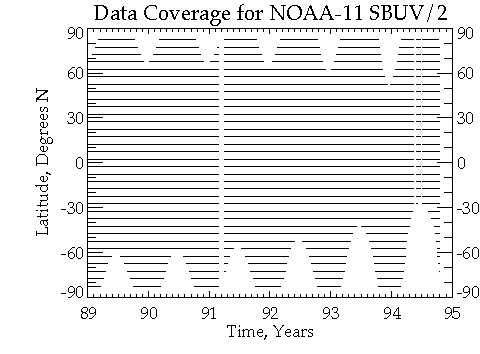
Figure 1.17. The geographic coverage for the NOAA-11 SBUV2 instrument, showing the decreasing coverage at high southern latitudes caused by orbit drift.
Ozone profiles and total column amounts are derived from the ratio of the observed backscattered spectral radiance to the incoming solar spectral irradiance, which is referred to as the backscattered albedo. The only difference in the radiance and irradiance observations is the instrument diffuser used to make the solar irradiance measurement; the remaining optical components are identical. Therefore, a change in the diffuser reflectivity will result in an apparent trend in ozone. An important improvement of SBUV/2 over the SBUV was the ability to measure changes in solar diffuser reflectivity in flight, using a mercury lamp as a light source (this lamp also provides wavelength calibration). This system did not work for the NOAA-9 SBUV/2 instrument but was redesigned and worked satisfactorily for the NOAA-11 instrument [Hilsenrath et al., 1995].
Spectral Resolution
The spectral resolution for SBUV (and TOMS) monochromators is 1.1 nm, FWHM. The bandwidth of the photometer is about 3 nm. The wavelength channels used for ozone retrievals for Nimbus 7 SBUV were: 256, 273, 283, 288, 292, 298, 302, 306, 312, 318, 331, and 340 nm. The wavelengths for NOAA-11 SBUV/2 were very similar except that Channel 1 was moved from 255.7 nm to 252.0 nm in order to avoid emission in the (04) nitric oxide gamma band that contaminated the SBUV Channel 1 measurement. Channel 1 data were not used in SBUV profile data.
Spatial Resolution
From an 800 km orbit, the instruments' (both Nimbus 7 and NOAA-11) 11.3ox11.3o instantaneous field of view (IFOV) results in an Earth scene size of about 200 km square. As the instrument IFOV moves along the satellite track, at roughly 6 km/sec, the Earth scene moves about 200 km during each 32 second spectral scan. Vertical resolution is determined by the radiative and scattering properties of the atmosphere for a nadir viewing instrument and is roughly 8 km in the upper stratosphere [Bhartia et al., 1996] Vertical resolution is discussed in more detail in the SBUV algorithm section.
Errors can be categorised as instrument calibration errors and algorithm errors. Pre-launch calibration errors are mostly systematic for SBUV measurements. The post-launch calibration can drift over time and directly affect derived ozone trends. For the most part, these can be corrected using on-board calibration systems. Algorithm errors and their dependence over time, such as those due to changing solar zenith angles and orbital drift can be quantified and are discussed in Section 1.5.3.
Pre-launch calibrations
The pre-launch calibrations and instrument characteristics for SBUV/2 have been described by Frederick et al. [1986] and Fegley et al. [1991]. SBUV and SBUV/2 employ nearly identical standards, traceable to the United States National Institute of Standards and Technology (NIST), and similar procedures for pre-launch calibrations. NIST secondary standards are used for irradiance calibration. Radiance calibration is derived by observing light from the irradiance standard reflected off a diffuse target whose bi-directional reflectance distribution function (BRDF) is accurately known. The lamp irradiance cancels in the albedo calibration. Extensive experiments and analysis have demonstrated that radiometric calibration are precise to better than 1% (2 sigma). Absolute diffuser BRDF values are known to about 3%. Non-linearities, wavelength errors, and other instrument factors have uncertainties that are less than 1%.
Recently, an integrating sphere has been successfully employed to calibrate the radiance sensitivity of BUV instruments (Heath et al., 1993). The integrating sphere has now been used to calibrate the SBUV/2, SSBUV, TOMS, and GOME instruments. These instruments have also been calibrated using diffuser targets whose BRDFs have been accurately measured. Comparison of integrating sphere and diffuser calibrations has shown agreement of about 1% for SSBUV, SBUV/2, and GOME. For TOMS the agreement ranged from 1-3%.
Out-of-band errors, or response to stray light, is measured pre-flight by pointing the instrument at the sun and comparing the radiance at 200 nm with that at 400 nm. Any relative signals larger than 1 ppm are considered stray light. Some SBUV/2 instruments have exceeded this threshold in the laboratory. For NOAA-11, correlations appear between the shortest profiling wavelengths and surface reflectivity, suggesting stray light problems. This contamination could result in a maximum error of as much as 10% for ozone at 1 hPa under certain lighting conditions.
Post launch calibration: Nimbus 7 SBUV
Long-term SBUV instrument corrections have been discussed elsewhere [Cebula et al., 1988]. Corrections to the data were applied by using a generalised Langley plot method [Bhartia et al., 1995], to further calibrate ozone profiles over the entire version 6 Nimbus 7 data set through 1990. In early 1987 the instrument began to lose synchronisation between its chopper wheel and its electronics, introducing apparent "noise" into the individual measurements. A correction procedure was developed for this non-sync error and the data reprocessed [Gleason et al., 1995]. These data do not appear to be biased but are generally noisier and should be considered inferior to the data preceding the onset of the non-sync errors.
Post launch calibration: NOAA-11 SBUV/2
The NOAA-11 SBUV/2 instrument response was monitored and corrected using on-board calibration systems from late 1988 until October 1994 when the diffuser mechanism failed, terminating the use of the on-board calibration system. Hilsenrath et al. [1995] have shown that measured albedo relative to the "day 1'' albedo over time is a function of true change in Earth radiance, diffuser degradation, and inter-range ratio (PMT gain). In order to accurately account for solar irradiances changes due to changes in viewing angle on the diffuser plate, the plate's angle-dependent reflectivity must be accurately determined over the life of the instrument.
Photomultiplier Inter-range Ratios
SBUV/2 instruments use three overlapping gain ranges to measure the solar and Earth radiation which varies over six orders of magnitude. Gain range 1 and 2 originate from the photomultiplier anode and can vary with time, while gain range 3 originates from the cathode and should be very stable. This design differs from SBUV where the anode was the source of all output ranges. For SBUV/2, measurements from the Earth and sun are output on different electronic gain ranges at shorter wavelengths and at high solar zenith angles. Therefore the instrument's electronic gain is not always cancelled out in the albedo ratio. The photomultiplier gain must be monitored and carefully evaluated over time for accurate calculations of long-term trends. Change in inter-range ratio (IRR), determined by the ratio of counts in two gain ranges when both ranges have valid data, as a function of wavelength The magnitude of the IRR decreased by about 15% over 5 years. For wavelengths shorter than 297 nm, the IRR's spectral dependence is based on pre-launch data and then extrapolated over time using the temporal dependence at the longer wavelengths. The spectral dependence was assumed to be constant over time. At solar zenith angles greater than 75°E, radiances at wavelengths shorter than 312 nm are on a range different than the corresponding solar irradiance measurement and therefore requires an IRR value for the albedo.
Diffuser Plate Calibration
Relative diffuser reflectivity over time, the most important component of the post launch calibration process for accurate ozone trend determination, is monitored with an on-board calibration lamp system. Diffuser degradation is monitored at six mercury lines spanning 185 to 405 nm. Figure 1.18 illustrates relative diffuser reflectivity at 254 nm over time in the upper panel. The lower panel illustrates diffuser degradation rate (%/year) for all six spectral lines. The 2 s limits on the fit are shown by the dashed lines. The largest degradation rate for the ozone channels is about 1.5%/year at 252 nm with an uncertainty of 0.2%.
Wavelength calibration is also monitored with the mercury spectral lamp. Absolute wavelength accuracy was determined to about 0.02 nm. Wavelength calibration drift was determined to be less than 0.01 nm over the five years of operation and has no observable effect on the derived ozone values. Beginning in late 1992 the grating drive began to occasionally fail to reach the correct grating position (1 position = 0.07 nm) in 5 channels. A three part correction was implemented to account for these events: 1) ozone cross section, 2) solar irradiance, and 3) multiple scattering and reflectivity. After correction, the effect of grating position errors is much less than 1%.
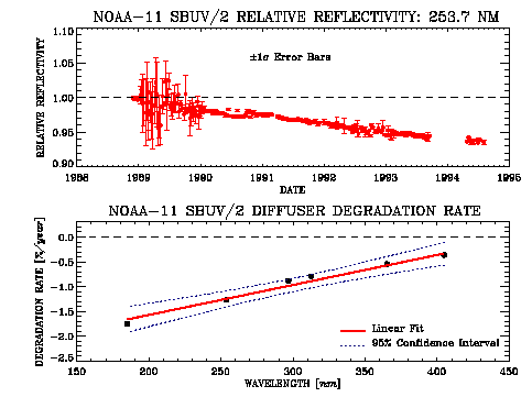
Figure 1.18. The relative diffuser degradation observed in the NOAA-11 SBUV2 instrument at 253.7 nm based on measurements of the on-board mercury lamp (upper panel). The wavelength dependent degradation rate is shown in the lower panel.
Periodic Shuttle SBUV (SSBUV) flights were conducted, principally to provide validation of long-term degradation of SBUV/2, but also to provide primary calibration data if the on-board calibration system failed, as was the case for the NOAA-9 instrument [Frederick et al., 1990]. SSBUV absolute calibrations and procedures were similar to those described for SBUV/2. The SSBUV instrument participated in several laboratory intercomparisons to establish calibration biases relative to other instruments measuring solar irradiance. These tests demonstrated that SSBUV absolute irradiance calibration error is less than 1% (2 s) over the ozone wavelengths relative to NIST irradiance standards [R.. Madden, NIST, private communication, 1993]. Subsequent comparisons, over the period 1993 to 1995, have shown that SSBUV irradiance calibration is maintained to better than 1% [Hilsenrath et al., 1993].
The on-board calibration system for the NOAA-11 SBUV/2 performed successfully for most of its lifetime. SSBUV's primary role was then to check and set the pre-launch calibration and validate the SBUV/2 performance over time. The validation technique is described by Hilsenrath et al. [1995] and is called the albedo normalisation factor (ANF) correction where albedo measurements are compared between two spacecraft. This correction employs coincident (with a one hour window) SSBUV and SBUV/2 albedo measurements. By means of a radiative transfer calculation, small differences in surface reflectivity, solar zenith angle, wavelengths, and ozone are accounted for when the measurements are compared between different spacecraft. The ANF for seven sets of coincident SSBUV and SBUV/2 observations corresponding to seven SSBUV missions are shown in Figure 1.19. Peak-to-peak ANF's (calibration errors) are about 3%, which translates to an ozone error of about 3% and 5% at 10 hPa and 1 hPa, respectively. Drifts in ANFs for the NOAA-11 data period are about -0.5% per year (+1.0% per year for ozone) at wavelengths corresponding to 1.0 hPa ozone and less than ±0.2% per year ( ±0.3% per year for ozone) at wavelengths corresponding to higher pressures. The residual calibration drift in SBUV/2 detected by SSBUV has large uncertainties because of the few samples (7) provided by the SSBUV missions. However they should be considered along with algorithmic drifts caused by the NOAA-11 drifting orbit when comparing SBUV/2 trends with other instruments.
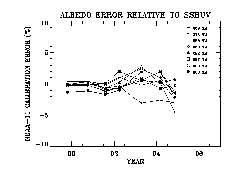
Figure 1.19. The relative error in the NOAA-11 SBUV2 radiance-to-irradiance ratio determined through comparison with 7 flights of the shuttle-based SBUV2 instrument (SSBUV).
The algorithm developed by NASA's Ozone Processing Team to obtain ozone profiles has been used to process data from the SBUV experiment on the Nimbus 7 satellite, and by follow-on SBUV/2 instruments on NOAA polar satellites. The algorithm described here is the most recent version (V6.0) of such algorithms, now the operational NASA and NOAA algorithm. This description of the algorithm is largely taken from a recent paper by Bhartia et al. (1996). The NOAA-11 SBUV/2 data analysed in this report are designated version 6.1.2; the ozone retrieval algorithm is the same as that used for SBUV, but an updated calibration and minor instrument-specific changes have been applied. A similar reprocessing of data from the NOAA-9 SBUV/2 instrument is currently (summer 1997) being done. In the following we shall use the lower case letters ''buv'' as a generic abbreviation for ''backscattered ultraviolet,'' and the upper case letters, e.g., SBUV, to refer to specific instruments.
Basis for Retrieval
Figure 1.20 illustrates the physical basis of the buv method for estimating the ozone profile. It shows the contribution to the buv radiances (255.5 nm to 331.2 nm) from different levels in the atmosphere. With increasing wavelength, the photons penetrate more deeply into the atmosphere, and thus sample different regions of the atmosphere. The contribution function is the fractional contribution to the backscattered radiance if one divides the atmosphere in layers of equal Dlog(p). Since the peak of the contribution function varies with a (the ozone cross section) times S (the optical path), one can scan the atmosphere by varying either a or S. The buv technique uses the former method; the ground-based Umkehr technique, which is based on similar principles, uses the latter method. The shortest buv wavelengths form clear contribution function peaks in the stratosphere and are used to infer the ozone vertical profile. The longest 4 buv wavelengths usually get their maximum contribution from the troposphere, so these wavelengths are used to infer total column ozone. At intermediate wavelengths two separate peaks can form and these wavelengths are sensitive to total column ozone as well as to the stratospheric ozone profile. The peak position and hence the information content of the radiances at any given wavelength, changes with solar zenith angle. Thus a wavelength suitable for determining total ozone at small solar zenith angle may become too sensitive to the ozone profile to be used for that purpose at large solar zenith angle.
The Backscattered Radiance Calculation
The problem of estimating buv radiances from the Earth's atmosphere varies considerably in complexity depending upon wavelength. At wavelengths shorter than 290 nm, where strong ozone absorption sharply cuts off the penetration of photons below 30 km (Figure 1.20), the buv radiances can be calculated by solving a relatively simple single-scattering problem in a purely Rayleigh-ozone atmosphere. However, at longer wavelengths the buv photons penetrate deep into the troposphere where they not only suffer multiple scattering in the optically thick Rayleigh atmosphere but are also affected by terrestrial surfaces, aerosols, and clouds. Given the computational complexity of these effects, it is convenient to consider the buv radiances as composed of two parts. The singly-scattered (SS) component, that includes just the primary scattering in an atmosphere consisting only of Rayleigh scattering, and the multiply-scattered and -reflected (MSR) component, that includes all other types of scattering and surface effects. During operational processing, the SS component is estimated accurately by numerical quadrature. The MSR component is estimated separately using a table look-up procedure.
Figure 1.20. The altitude dependent contribution to the radiance backscattered from the atmosphere.
Considering only Rayleigh scattering and ozone absorption, the singly-scattered component Iss of the buv radiances is given by,
Iss(l) = Fl bl P(q)/4p ù exp[-S(p) {al X(p) - bl p}] dp
where, Fl is the solar flux at wavelength l, bl the effective Rayleigh scattering coefficient per unit pressure, P(q) the Rayleigh scattering phase function for a scattering angle q, al the effective ozone absorption coefficient per unit ozone amount, S(p) the slant path (air mass), and X(p) is the column ozone above the pressure p.
At wavelengths longer than 290 nm, the incoming photons penetrate into the lower atmosphere where they may undergo multiple scattering. In addition, one must consider the effects of surface reflection and Mie scattering by aerosols and clouds. Since these effects are highly variable and cannot be modelled accurately, the buv technique relies on the concept of Lambert-equivalent reflectivity, introduced by Dave (1977). In this concept, one estimates the buv radiances by radiative transfer calculation for an idealised atmosphere that contains ozone and Rayleigh scattering, but no Mie scatterers, and is bounded by an opaque Lambertian surface. The effective reflectivity, R*, and effective pressure, p*, of this fictitious surface are estimated by using the measured radiance at the longest buv wavelength (339.8 nm), where the ozone absorption is very weak. The MSR radiances are computed by using the auxiliary equation solutions of the radiative transfer equation (Dave, 1964), which accounts for polarisation and all orders of scattering. However, Earth's sphericity effects are included only in the calculation of primary scattering. Recent calculations (Caudill et al., 1997) indicate that this approximation produces errors of less than 1% in radiances at solar zenith angles up to 88°. For computational efficiency, a table look-up procedure is used to compute the MSR component of I. The table look-up procedure works because the ozone profile dependence of IMSR is weak. The MSR radiation is generated primarily in the troposphere (below 100 hPa).
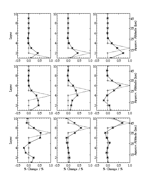
Figure 1.21. Averaging kernels for individual Umkehr layers for the SBUV retrieval algorithm showing the expected sensitivity to perturbations at various altitudes.
The Inversion
The general problem of inverting buv measurements to derive an ozone profile is ill-conditioned. One must apply some sort of constraint to achieve a physically reasonable solution. There are several ways of specifying these constraints. One may, for example, constrain the profile to follow a pre-defined mathematical function with adjustable parameters that are selected to best fit the measurements; or select a profile that has the highest probability of being the correct profile based on a priori statistical information (Rodgers, 1976). The buv profiling algorithm uses a combination of both of these strategies.
The ozone profile is mathematically defined by a cubic interpolating spline (in the Umkehr coordinate system layers logX vs. logp with 12 fixed nodes at p=2-n atm, where n=0, 2, 3...12 (note that n=1 is missing). The algorithm first obtains X at n=0, i.e., the total column ozone, using the longest 4 buv wavelengths. Total ozone is used to estimate IMSR as well as to select first guess ozone values at the lowest 5 nodes from a library of ozone profiles. Next, ozone values at the 4 uppermost nodes are estimated using measurements at the shorter buv wavelengths. A cubic spline curve fitted to these 9 nodes forms the starting profile, which is iteratively adjusted until the retrieval converges to a solution profile. The following sub-sections discuss this procedure in more detail.
Total Column Ozone
Total ozone is derived using the 4 longest wavelength bands of the instrument (Dave and Mateer, 1967; Klenk et al., 1982; McPeters et al., 1996). Since these references discuss the total ozone algorithm in adequate detail, we provide here just an overview. The buv total ozone technique is based on the observation made earlier that at certain wavelengths the buv photons penetrate most of the ozone column to reach the troposphere, whence they are scattered by the dense atmosphere, clouds, aerosols, and surface. When the peak of the contribution function is in the troposphere, the logarithms of buv radiances decrease almost linearly with ozone column amount, approximately following the Beer's law of absorption. Since this relationship is not perfectly linear but has a small dependence on ozone profile and temperature, one needs to perform accurate radiative transfer calculations using climatological profiles to describe the curves relating the buv radiances to total column ozone under a variety of observing conditions. Total column ozone is derived in a table look-up procedure described in the references cited earlier.
Construction of First Guess Profile
The first guess profile is constructed by fitting a cubic interpolating spline with natural boundary conditions to the logX vs. logp curve. The piece-wise linear curve given by the Thomas and Holland (1977) solution, linearly extrapolated, provides the cumulative ozone X at the 4 topmost points, at p=2-n atm, with n=9, 10, 11, 12. The value of X at n=0 is simply the total column ozone. Values of X at n= 2, 3, 4, 5, are obtained using a library of standard ozone profiles constructed by combining data from SAGE (McCormick et al., 1989) with ozonesonde data. A profile for a given total ozone amount and latitude of measurement is obtained by bi-linear interpolation (low latitude profiles are extended to the equator and high latitude profiles to the pole). Given the values of X at the 9 nodes, the values at the missing 3 nodes (n=6,7,8) are obtained by spline interpolation.
Retrieval of Final Ozone Profile
The buv algorithm assumes that the MSR component of the total measured radiation contains no retrievable ozone profile information. Since the total ozone information that it does contain has been obtained previously using the longer buv wavelengths, IMSR is treated simply as a contamination to the measured radiance and is subtracted out. The retrieval scheme, therefore, is based on single-scattering kernels and singly-scattered radiances. Measurements made at the longest 4 wavelengths (3 at high solar zenith angles) that have already been used in deriving R* and are not used explicitly. Instead, the total ozone derived from them is considered a measurement and is included with the radiance measurements at the other 8 wavelengths (9 at high solar zenith angles, by including the 312.5 nm wavelength). Although this scheme of handling the measured radiances may appear unnecessarily tedious, it was done primarily to save computation time. Back-calculations using the retrieved profiles show that, in most cases, the derived ozone profile explains the measured radiances at all 12 wavelengths to a high degree of precision (~1%).
The final retrieval of an ozone profile is a straightforward implementation of Equation (101) of Rodgers (1976) reproduced below.
xn+1 = xa + Sx KnT (Kn Sx KnT + S)-1 [(y - yn) - Kn (xa - xn)]
In this equation, xa is the a priori profile. The solution starts with a first-guess profile x1, from which the kernels K1 and measurements y1 are evaluated, and proceeds through n iterations until the retrieved profiles stop changing to within a specified tolerance. Although x1 is not required to be the same as xa , they are made the same in the buv algorithm. Strictly speaking, since measured radiances are used in constructing xa, one does not have a true a priori profile to which the solution is constrained. This violates the tenets of optimal estimation theory upon which this equation is based. However, the principal impact of this violation is to complicate the error analysis of the algorithm.
Ozone profiles derived from the inversion are reported as ozone amounts (in DU) in 12 layers defined above, as well as ozone mixing ratios at 19 standard pressure levels. The latter are obtained from the first derivative of the cubic spline curve. However, as discussed in previous sections, the buv radiances are directly sensitive to the column amount of ozone above a pressure surface. To compute layer ozone amounts or mixing ratios one must difference two numbers. In the upper stratosphere, where the column amount of ozone is changing rapidly, the numerical differentiation process increases the error only modestly. Below the ozone density peak, however, one must difference two large numbers to obtain a small number. This can lead to large error enhancement, particularly in the tropical lower stratosphere, where the amount of ozone in a layer, as a fraction of the ozone column above, is the smallest.
Information Content
A convenient way of examining loss of information due to inversion is to treat the algorithm as a ''black box" and study its response to perturbations in the ozone profile. Rodgers (1990) recommends a variant of this technique based on a concept called the averaging kernels. Besides having an elegant physical interpretation, averaging kernels are very convenient for comparing profiles from a low-resolution instrument with those from a high-resolution instrument. Using the averaging kernels and the a priori profile one can immediately tell what profile the algorithm would produce for a given "truth" profile from another sensor.
A form of averaging kernel where the first guess is included in the "black box" is shown in Figure 1.21. Between 1.5 hPa and 20 hPa, the algorithm reproduces the input perturbation reasonably well except for broadening the FWHM to about 10 km. These results are derived using the 252 nm wavelength of SBUV/2. If the shortest SBUV wavelength is not used, the upper range of validity drops below 1.5 hPa. at low solar zenith angles. Above 1.5 hPa and below 20 hPa the response has the wrong shape, with misplaced peak positions. These results are in general agreement with previous conclusions (Rodgers, 1990). The primary reason for the distorted response is that in the region of the atmosphere where the information from the buv radiances is low, the algorithm relies on a priori information more heavily. Since the Gaussian impulse puts perturbations in the atmosphere that are very different from a priori information, the algorithm finds a compromise answer that poorly reproduces the impulse.
Errors in retrieved ozone profiles come from 3 independent sources: measurement errors, error in calculating radiances from a known ozone profile, called the ''forward model errors'', and error in inverting the radiances to obtain an ozone profile, called the ''inverse model errors''. These errors are discussed in detail in Bhartia et al. (1996). To estimate the effect of these errors we use high vertical resolution ozone profiles generated by the SAGE instrument. Direct comparison between SAGE II and SBUV derived ozone profiles have been made (McPeters et al., 1994; Rusch et al., 1994). However, these comparisons fail to provide unambiguous answers about the capability of the buv inversion algorithm itself, for they are affected by differences in the spatial and temporal location, instrumental errors, and forward model errors of both instruments. From a SAGE data set, consisting of 1655 individual ozone profiles matched to SBUV profiles, the buv radiances were computed using the average solar zenith angle seen by the SBUV instrument in the latitude band where SAGE took measurements. The computed buv radiances were then used to derive ozone profiles using the algorithm discussed in this paper.
As expected, the SAGE comparisons show that the buv technique can measure the cumulative ozone amounts above a pressure surface to a high degree of precision. Figure 1.22 shows that, in the absence of measurements errors, layer ozone amounts between 0.7 hPa and 10 hPa are retrieved with a precision of 2-3% with a standard deviation under 2%. Lower layers are not shown since the percentage errors for these layers lose meaning as noted earlier. Cumulative ozone is the direct product of the buv
Figure 1.22. An estimate of the ability of the SBUV algorithm to retrieve ozone made using radiances theoretically calculated from an ensemble of 1655 real (SAGE) profiles. The average difference is shown in the left panel, while the standard deviation of the retrieved profiles is shown in the right panel.
inversion - between the surface and 55 km it is derived with a precision of better than 2%. One notes that the errors do not average to zero when large number of profiles are averaged. This is a consequence of the a priori constraint which may introduce systematic errors if the a priori profile is not the ensemble average of the subset of SAGE II data examined. This appears to be the case in the lower layers at southern mid-latitudes.
Figure 1.22 showed that ozone perturbations between 1.5 hPa and 20 hPa would be accurately retrieved by the algorithm. Because the altitude at which the scattering contribution peaks is determined by the product of the ozone cross section (wavelength) times the optical path, the maximum altitude accurately retrieved will move upwards as the solar zenith angle increases. If the maximum altitude is 1.5 hPa for zenith angle less than 60o, the profile will be valid up to 1.0 hPa by 75o and to 0.7 hPa by 85°. As a result profile retrievals at high latitudes in winter extend higher in the atmosphere.
Another interpretation is that the same altitude is measured by longer wavelengths as the solar zenith angle increases. This can cause an error in the trends derived from the NOAA-11 SBUV/2 because, as was shown in Figure 1.17, the orbit of the NOAA-11 spacecraft drifted towards the terminator (higher solar zenith angles) over its life. The result is that any wavelength dependent error will directly produce an ozone trend error. Figure 1.23 shows the theoretical change in the profile (trend) caused by an orbit drift from a 30° zenith angle to a 60° zenith angle if a wavelength dependent calibration error is assumed. For the 8 profile wavelengths 252 nm to 306 nm, errors are assumed of -0.5, +1.0, +1.0, 0.0, 0.0, -1.0, +1.0, and 0.0% respectively. These are realistic possible errors suggested by the final residues from the SBUV/2 processing and within the uncertainty of the calibration. They show that a trend error of 1 to 2% over the six year life of SBUV/2 is possible. A similar assumed error in the SBUV calibration would result in an altitude dependent bias, but would not produce a similar trend error because the Nimbus 7 orbit was very stable.
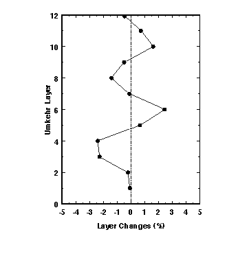
Figure 1.23. An illustration of how an assumed calibration error that does not vary with time can produce an apparent time and altitude dependent trend as a result of an orbit that drifts to higher solar zenith angles (from 30o to 60o).
Table 1.8. contains estimated errors (90% limits) for SBUV from the algorithm [Bhartia et al., 1996] and from the calibration, and an estimate of the error in maintaining the calibration [Bhartia et al., 1995]. Since many of the components of these are errors that are systematic, they will not be completely eliminated by averaging profiles.
|
(hPa) |
% |
% |
%/year |
|
|
|
|
|
|
|
|
|
|
|
|
|
|
|
|
|
|
|
|
|
|
|
|
|
|
|
|
|
|
|
|
|
|
|
|
|
|
|
|
|
|
|
|
|
Table 1.8. SBUV Error summary
![]()