 |
Stratospheric Processes And their Role in Climate
|
||||||||
| Home | Initiatives | Organisation | Publications | Meetings | Acronyms and Abbreviations | Useful Links |
![]()
|
Stratospheric Processes And their Role in Climate
|
||||||||
| Home | Initiatives | Organisation | Publications | Meetings | Acronyms and Abbreviations | Useful Links |
![]()
The UARS Microwave Limb Sounder (MLS) measurements are obtained from observations of millimetre-wavelength thermal emission as the instrument field of view is vertically scanned through the atmospheric limb. The MLS instrument is described by Barath et al. [1993] (see also Waters, 1993). The instrument has three main subsystems: the antenna, the 3 radiometers (measuring radiances at frequencies near 63, 183, and 205 GHz), and the filter banks. The signal entering the radiometer contains radiances emitted by the limb of the Earth averaged over the antenna field of view (FOV) and each spectral filter, and a small ''extraneous radiance'' comprised of thermal emission from the instrument (mostly the antenna primary element), scattered radiances from the primary mirror's surface roughness, spill over of the primary past the secondary, and edge diffraction. The thermal component of the extraneous radiance is spectrally flat over the filter bank bandwidth and scan independent, but the scattered and diffracted components may be weakly dependent on scan-angle. Calibration is accomplished by interspersing several space views (at 2.7 K) and calibration target views (at about 300 K) with the (typically 26) limb views during each 65 second scan of the atmospheric limb via a switching mirror located between the antenna and the radiometer(s). The radiances (or brightness temperatures) of the target (inferred from its measured emissivity and temperature) and space, along with pre-launch calibration measurements of the losses along optical paths, are incorporated in a linear model relating limb counts to limb radiances; the radiometric gain is the proportionality constant in this relation (see Jarnot et al., 1996). Departures from a linear relationship are estimated to be less than 0.1%.
The MLS instrument uses double-sideband heterodyne radiometers: signals from two sidebands, equally spaced about the local oscillator frequency, are combined (with slightly unequal weights) through the use of whisker diode mixers into a single measurement. The weights, or sideband ratios, are measured for each channel as part of pre-launch instrument calibration. There are fifteen channels across each of the bands obtained in 510 MHz wide filter banks. Channels have similar characteristics on each side of the line centre and are narrower near the centre; signal-to-noise is roughly proportional to the square root of the channel width. The 15 channels dedicated to the 205 GHz ozone line (a line centred at 206.132 GHz, or 1.45 mm wavelength) are referred to as ''band 4'' . Another ozone line is measured at 184.378 GHz (1.63 mm wavelength), but that radiometer failed in April 1993. The MLS ozone data mentioned in this report refer to the longer-term 205 GHz ozone data. There are other species that emit weakly in the 205 GHz ozone line region, namely SO2 (with a contribution primarily during the first year after the Mount Pinatubo eruption), HNO3, and H2O (from the lowermost stratosphere and upper troposphere). Other contributions include emission from the wing of a N2O line outside the target band pass, which becomes significant only in the lowermost stratosphere, and very small emission features from HO2 and a heavy (symmetric O18OO isotope) ozone line (see Froidevaux et al., 1996).
The MLS measurements have very high spectral resolution, as alluded to above, with the ozone line being resolved through the use of 15 channels; the centre channel has a width of 2 MHz, and the two broadest wing channels have a width of 128 MHz. The spatial resolution is given by roughly 400 km along the line of sight (perpendicular to the UARS velocity), from radiative transfer considerations; a similar amount of smearing occurs along the tangent track, because of the satellite motion during a 65 s scan (for which an individual ozone profile is retrieved). The vertical resolution is constrained by the FOV vertical extent at the tangent point (3 km half-power beam-width for the ozone measurements); however, the MLS data (for Version 4 and earlier) are produced on a vertical grid with points spaced each factor of 101/3 (or 2.15) change in atmospheric pressure, giving a vertical resolution of ~5.4 km. The limb scan used in normal operations consists of discrete steps between about 90 and 0 km tangent heights, with step spacing for the scan varying between 1 km in the lower stratosphere to 5 km in the mesosphere; individual spectra are measured during 1.8 s dwells between steps.
MLS performs routine measurements continuously every day (except when satellite or instrument-related problems occur), both day and night. The measurement latitudinal coverage is from 34° on one side of the equator to 80° on the other. UARS performs a yaw manoeuvre at roughly 36-day intervals (a ''UARS month''), when MLS high-latitude coverage switches between north and south. Within each UARS month the UARS orbit plane precesses slowly with respect to the Earth-Sun line. The orbit precession causes the measurements to sweep through essentially all local solar times during the course of a UARS month, becoming 20 min earlier each day at a fixed latitude.
The typical profile spacing along the orbital track is 3 to 4° in latitude, with significantly denser coverage in small bands close to the turn-around points (near 34 or 80° of latitude). The spacing between orbits in longitude is typically about 25°, but since there is overlap arising from ascending and descending portions (for day and night side, typically), the average daily sampling in longitude (for a latitude bin a few degrees wide) is about 12°.
After 2.3 years in orbit (in late December 1993), the antenna-scanning mechanism began to exhibit signs of wear. March 1994 through May 1994, and July 1994 were periods of testing and significantly reduced data gathering; these months have from one third of the days with bad data to almost all bad days (days with no profiles retrieved). August and September of 1994 contain mostly good data, but the months of October 1994 through January 1995 again have very few days of useful atmospheric profile data. Reverse scanning and other modifications to the operations (including short periods of "mechanism rest" every orbit) have been implemented since February 1, 1995. Very little limb data gathering (typically only a few days per month) occurred from February through July 1995, which was a period during which instrument power sharing began for UARS (in May 1995) because of poor solar array performance (the solar array was then parked indefinitely without subsequent rotation).
Since June 1995, MLS has been in a mode of operation characterised by off periods for power savings and on periods during which typically 2 days of full (reverse) scans are obtained followed by one day of limb tracking at altitudes near 18 km. The limb tracking days do not lead to standard catalogued profile data files, although there is some information on the atmosphere from those days. The August 1995 through September 1996 time period generally contains about one half to one third catalogued good days for atmospheric profiles, and this mode of operation is expected to continue. MLS has been operating without "scan slips" since January 1995. However, instrument operations were significantly reduced after June 1997, when one of the 3 UARS batteries failed, further reducing power availability.
Instrumental sources of error arise from radiance noise (random errors; see Jarnot et al., 1996), and systematic sources, namely possible uncertainties (and possible changes with time) in the antenna FOV and antenna surface properties, the channel spectral responses (filter shapes), the radiometric gain, the channel sideband ratios, and the extraneous radiance (scattering and emission). Non-instrumental errors can also arise from the forward and inverse numerical models (discussed later). Further discussion of most of the above can be found in Froidevaux et al. [1996] and in subsequent parts of this report (e.g. error characterisation section).
Forward Model
The forward model used to describe the calibrated radiance signals received by MLS is a first order Taylor series of a local thermodynamic equilibrium (LTE) radiative transfer calculation (with no scattering) averaged over the spatial and spectral responses of the instrument (details are given by Read et al., manuscript in preparation, 1997). The independent variable or state vector is a mixing ratio profile gridded every 1/3 in log10 pressure, with the grid points connected by linear segments. The linearisation values assume a climatological mean grouped into eight 20o latitude bins and 10 periods (corresponding to UARS months) per year. The radiative transfer calculation uses spectral filter shapes and a field of view gain pattern collapsed into the elevation dimension determined during pre-launch calibration. The one-dimensional field of view averaging neglects radiance azimuthal variation which would be created by the curvature of the Earth and along track variations in the constituents. Line-of-sight gradients are ignored in the forward (and inverse) model representations so far.
The absorption functions used in the calculation employ a line-by-line plus a background continuum contribution for each species. The total absorption is arrived at by summing all individual species contributions. All ''important'' species are included in addition to the O3 emission near 205 GHz, namely N2O, H2O, H218O, HNO3, O3 v-2, O18OO, SO2, and N2/O2 continuum. A Van-Vleck Weiskopf line shape with no interline interference effects (except for O2 which includes it) is used for each line and the total contribution is obtained from a sum over contributions from all lines and a continuum.
The 205 GHz O3 radiance is quite linear in concentration and a pre-frequency averaging approximation is used where the absorption coefficient is averaged over the spectral response before performing radiative transfer calculations. This approximation is not used for the stronger and more non-linear 183 GHz O3 measurement. The derivatives in the Taylor series are computed analytically, fully incorporating the representation basis function shape, which is considerably faster than using finite differences. Given that the linearised forward model is not as accurate as the complete radiative transfer model, the radiance uncertainties have been increased by an ''inflator factor'' (0.5 % of the radiance for the 205 GHz ozone band).This includes possible errors caused by non-linearity, finiteness of the vertical grid used (1 km grid), and frequency averaging methodology. It does not attempt to include possible errors arising from other factors mentioned above.
Inverse Model
The MLS approach used for retrieving geophysical parameters, such as tangent pressure, temperature, and mixing ratios, from the calibrated radiances (Level 1 data), is based on sequential estimation, as first applied to limb sounding by Rodgers [1976]. This technique combines a priori information (such as climatological profiles with an associated error covariance) with measurement information, to produce a solution for the desired parameters and error covariances. The a priori ''state vector'' is used to stabilise the solution in regions of poor sensitivity and to provide some continuity. This methodology can be viewed as a combination of the a priori information and the weighted least squares solution to the linearised equation relating measurements and state vector (see Appendix of Froidevaux et al., 1996, for a simple derivation). The calculated radiances and their derivatives are obtained by table look-up (for speed of evaluation) from climatological conditions and then interpolated in the vertical to the tangent pressure. Radiances are interpolated with respect to (logarithm of) tangent pressure using cubic splines and with respect to other variables via the linearised form of the forward model (see above).
In addition to the radiance error ''inflator factor'' mentioned above in relation to (some of the) forward model uncertainties, a radiance error term is added to account for error contributions from variables which are constrained to certain values (based on a priori or retrievals from other bands). For example, temperature and tangent pressure uncertainties, after their evaluation from band 1 retrievals, have their uncertainties propagated to mixing ratio estimates in this way; also, uncertainties arising from velocities (Doppler shifts) along the FOV direction are treated in this fashion, with no values retrieved, but with the (a priori) uncertainty estimates included in the equations for mixing ratio updates. In terms of the estimated error covariance (whose diagonal elements give the uncertainties in the MLS data files), the retrieval software produces uncertainties which are flagged as negative under conditions of poor measurement sensitivity (see details in Froidevaux et al., 1996).
Another important feature of the MLS retrievals used in the production of Version 4 data is the use of an ''opacity criterion'' which eliminates radiances corresponding to optical depths greater than unity along the line of sight, because of non-linearity concerns (given the non-iterative linear scheme used so far). The UARS MLS Level 3 data are output on the UARS pressure grid (1000x10-n/6 hPa values), which is twice as fine as the Version 4 MLS retrieval (Level 2) grid; adjacent Level 2 grid values are averaged to fill in the Level 3 grid on the ''odd'' UARS surfaces. Finally, it was found from simulations that better retrievals were obtained if radiances arising from tangent pressures larger than 100 hPa were not included, at least for the non-iterative retrievals used to produce Version 4 (and prior) MLS data.
The a priori values used for ozone are based on the ozone climatology from Keating et al. [1989a,b], with extrapolations for the poorly represented lower stratosphere (at pressures over 20 hPa). Other details are given in Froidevaux et al. [1996]. A priori uncertainties are generally chosen conservatively (i.e., large values are used) in order to minimise possible biases. For ozone a 3 ppmv a priori uncertainty is used in the stratosphere down to 50 hPa, with a 2 ppmv uncertainty at 100 hPa, and significantly tighter constraints in the troposphere (where not enough measurement sensitivity exists). A priori uncertainties decrease smoothly with decreasing pressure in the mesosphere, until about 0.2 hPa, above which an uncertainty of 1 ppmv is assumed. The use of a ''global'' a priori uncertainty is clearly an oversimplification of the variability of the real atmosphere. The possibility of larger-than-appropriate estimated uncertainties in the retrieved profiles exists as a result of this approach, for regions like the lowermost stratosphere where poorer measurement sensitivity exists; however, this is a safer approach than the use of a priori uncertainties which are too small, since this can lead to undesirable biases with unrealistically small estimated uncertainties. Based on sensitivity tests of the influence of a priori values, it was confirmed that the 205 GHz ozone retrievals are affected in a non-negligible way by the a priori for pressures near 100 hPa and above about 0.46 hPa. The range of recommended pressures for Version 4 (and prior) MLS data has been 46 to 0.46 hPa, with most improvements needed in the lowermost stratosphere (100 hPa in particular), where measurement sensitivity and accuracy are poorer.
Averaging kernels (see the description of error characterisation by Rodgers, 1990; also Marks and Rodgers, 1993) for MLS ozone are well-peaked functions with some degradation in measurement sensitivity occurring in the lower mesosphere and at 100 hPa for the 205 GHz ozone data (see Figure 1.13). Most of the smoothing arising from the MLS measurements is caused by the use of the fairly coarse Level 2 retrieval grid (not by the instrument FOV or radiative transfer smearing).
Figure 1.13. Averaging kernels for MLS ozone 205 GHz data (Froidevaux et al., 1996).
MLS Version 4 Data
A few changes were made between the Version 3 ozone data described by Froidevaux et al. [1996] and the Version 4 data used in this report. A post-launch estimate of the pointing offset between the 63 and 205 GHz radiometers is now used (this was obtained from MLS antenna scans across the moon, see Jarnot et al., 1996); the pointing offset change from Version 3 corresponds to a tangent height change of about 430 m (with larger tangent heights in V4, relative to the 63 GHz FOV). Also, HNO3 is retrieved in Version 4 from band 4 radiances (in addition to ozone), with some impact on ozone in the lowermost stratosphere. Radiances for tangent pressures of 100 hPa are included in Version 4 by spline interpolation of the radiances to minimise vertical sampling gaps sometimes present in Version 3 (but a criterion to neglect optically thick radiances is still in effect in Version 4). Ozone values are also affected by changes which occurred in band 1 (for temperature and - mostly - tangent pressure, from O2 spectroscopy changes - see Fishbein et al., 1996).
Average differences between V4 and V3 MLS ozone data are displayed in Figure 1.14, for the late 1991 to end of 1996 time period. V4 ozone values are typically a few percent lower than V3 data, in the 22 to 0.46 hPa range, with variations in these differences across month or latitude varying only at the 1 to 2 % level. At 46 hPa, V4 ozone values are typically systematically lower than in Version 3 (by about 15 to 25%), with largest V4-V3 differences in the tropics and smallest (< 10%) differences at high latitudes. At 100 hPa, V4 values are generally larger than V3 values, especially at low latitudes, where the increase is often large (between 0.5 and 1 ppmv), leading to significant changes in latitudinal gradients. Column ozone above 100 hPa is typically 5-10 % smaller in V4 data than in V3 data.
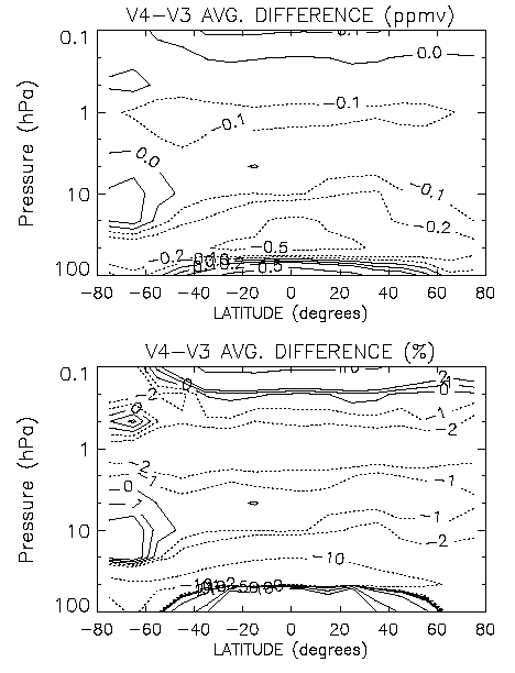
Figure 1.14. Average difference for V4-V3 MLS data versus pressure and latitude, for the time period from late September 1991 to the end of 1996. Top panel shows differences in ppmv, bottom panel in percent.
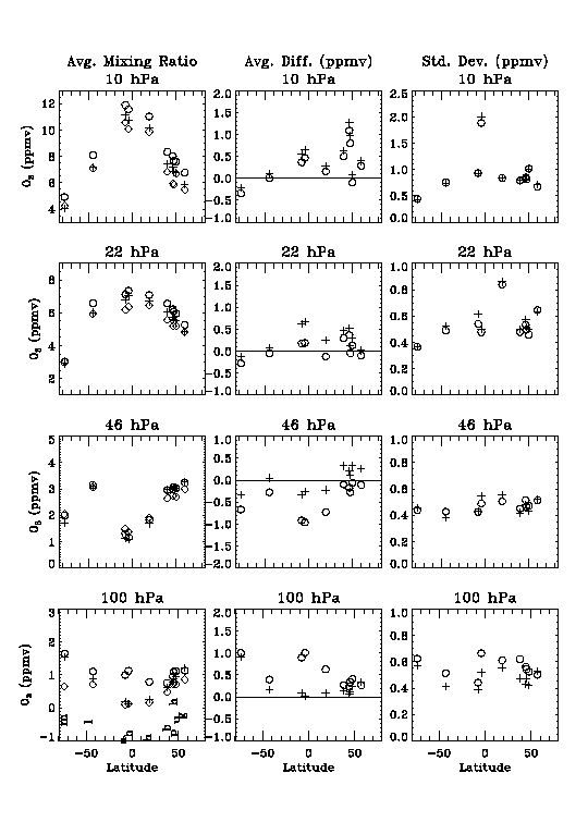
Figure 1.15. MLS data compared to ozonesonde data at various latitudes and pressures. Left panels give average sonde values (diamonds) and MLS version 3 (plus signs) and version 4 (circles) average values. The centre panels give average differences (MLS-sonde), with v3-sonde as plus signs and v4-sonde as circles; the right panels show the standard deviations of the differences (using the same symbols). The site locations from South to North are: McMurdo (78S), Lauder (45S), Ascension Island (8S), Brazzaville (4S), Hilo (19N), Boulder (40N), Hohenpeissenberg (45N), Payerne (46N), Uccle (50N), and Gardermoen (60N). Time periods covered for each case and number of coincident profiles are as follows, in the same order of sites: Aug. 92-Oct. 92 (17 profiles), Oct. 91-Apr. 96 (96 profiles), Oct. 91-Oct. 92 (27 profiles), Oct. 91-Aug. 92 (28 profiles), 1992 data (29 profiles), 1992 data (42 profiles), Oct.91-Apr. 96 (176 profiles), Oct. 91-Dec. 94 (127 profiles), Oct. 91-Apr. 96 (208 profiles), and Feb. 93-Feb. 94 (30 profiles).
There is evidence that the lowermost stratospheric data (from 46 to 100 hPa) at low latitudes in Version 4 are not as reliable (compared to correlative data) as the Version 3 data, although negative biases at 100 hPa existed in Version 3 data. Version 4 values at 100 hPa are sometimes unrealistically large, and the 46 hPa values can be too small (in a compensating way). This is illustrated in Figure 1.15, where ozonesonde data are compared to MLS V4 and V3 retrievals. The main problem occurs at low latitudes in the lowermost stratosphere, with 100 hPa V4 MLS values being significantly too large, and V4 values being too small; the next version of MLS data seems to rectify this kind of bias. At other latitudes, and at other pressures for most latitudes, there are indications that V4 data are slightly improved (versus sonde as well as versus SAGE II data) over V3 data.
To illustrate how Versions 3 and 4 data track each other over the 1991-1996 time period, slope values from linear regression fits of the V4-V3 difference time series (averaged in 10° latitude bins) are displayed in Figure 1.16. Most of the differences in the rates of change are not statistically significant at the 95% confidence level. There is excellent tracking between the two data sets in the 22 to 1 hPa region (typically within a few tenths of a %/year). The largest differences occur where the mean biases between the two versions are largest (and where poorer measurement sensitivity exists), namely in the lowermost stratosphere, primarily at 100 hPa in the tropics.
Given that there are still some bias issues with MLS V4 ozone data in the lowermost stratosphere, particularly between 30°S and 30°N, and that this is also the region where the rates of ozone change have changed the most and are more uncertain (in ppmv/year as well as in %/year), less weight should be given to this data set in that region.
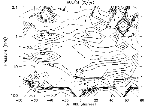
Figure 1.16. Slope (percent/year) of regression line for the MLS V4-V3 difference time series as a function of pressure and latitude (data were binned in 10° bins).
The error sources which can impact MLS ozone retrievals can arise for the following reasons: (1) radiance noise (random error); (2) radiance scaling error (includes radiometric, sideband ratio, and line strength errors); (3) error in filter shapes; (4) error in FOV direction (relative to the 63 GHz radiometer FOV used for tangent-point pressure retrievals); (5) error in FOV shape (includes spectral dependence); (6) error in ozone line width; (7) errors from retrieval numerics; (8) error contribution from a priori; (9) error in Ptan; (10) error in atmospheric temperature; (11) error in dry air continuum; (12) error in knowledge of H2O; (13) error in knowledge of HNO3; (14) error in knowledge of N2O; (15) error in knowledge of SO2. The above error sources (except radiance noise) lead to mostly systematic errors, and the MLS ozone sensitivity to these factors has been described by Froidevaux et al. [1996]. The main sources of systematic error (especially in the lower stratosphere) arise from possible errors in tangent pressure, temperature, and the modelled dry air continuum. Precision and accuracy values are plotted and tabulated in Froidevaux et al. [1996], based on a consideration of the above error sources, and consistent with conclusions arrived at from inter-comparisons with other data sets; the pressure-dependent (total) accuracy and single-profile precision is given here in Table 1.6.
|
|
|
|
||
|
|
|
|
|
|
|
|
|
|
|
|
|
|
|
|
|
|
|
|
|
|
|
|
|
|
|
|
|
|
|
|
|
|
|
|
|
|
|
|
|
|
|
|
|
|
|
|
|
|
|
|
|
|
Table 1.6. Estimated Precision and Accuracy of MLS 205 GHz Ozone Profiles.
In terms of potential sources of error for trend analyses of MLS data, time series of engineering data (such as shown in Jarnot et al., 1996) suggest that changes in instrument performance (radiometric scaling, spectral response, and extraneous radiance) are significantly less than 1 percent over the 1991 to 1997 time period. A few changes in MLS operations over the course of the mission, such as modifications to the instrument control program or power interruptions (see Fishbein et al., 1996), might have had a small impact on instrument behaviour, although nothing is obvious in the retrieved profiles. Since the retrievals take out an offset between modelled and measured radiances, it is improbable that small trends or variations in extraneous radiance (possibly caused by spacecraft surface degradation, as viewed by the antenna spill over lobes) would have a significant impact on the ozone data. Radiometric gains have remained extremely stable over the mission lifetime, but changes in these are removed as part of the calibration. The blackbody target temperature is monitored to calculate target radiance, but the target emissivity could change (in theory); this would have minimal impact because of the compensating effect of the radiation it receives and reflects from the surrounding structure at a similar temperature. A change in antenna surface properties, although unlikely based on past experiences of such aluminium surfaces in space (at microwave wavelengths), would translate into an error in limb radiance (and retrieved ozone). Time series of calibrated radiances from the highest altitudes place limits on such changes; based on such time series, we estimate that the antenna system reflectivity (with a value of 0.989) has changed by less than 0.0001 over 6 years.
This places a bound on possible stratospheric ozone changes in relation to MLS antenna degradation of much less than 1 percent over this time period. Changes in the FOV with time would also be difficult to detect (not easily monitored with high accuracy); however, since the FOV is determined by bulk geometric properties of the reflectors, optics and feed horn, catastrophic events are far more likely sources of change than slow degradation (and they would have been noticed). A frequency shift or drift (in terms of the measurements of the ozone line) could also in theory lead to a spurious ozone trend; this could be investigated by looking at changes in the characteristics of radiance residuals (or c2 values) versus time, but this has not yet been done. An unknown change in receiver spectral sideband response would also impact the retrieved ozone, but MLS engineering data on the mixer bias levels provide no indication of any such changes. Errors as a function of time in retrieved temperatures could affect the MLS ozone trends at a small level. Stratospheric aerosol effects at the MLS wavelengths are expected to be negligible (and are not observed in the radiances during the Mount Pinatubo loading of the lower stratosphere); Cunnold et al. (1996) have used comparisons between MLS and SAGE II ozone to correct SAGE II data for aerosol effects. Our best current estimates of known possible sources of error and their impact on MLS-derived trends is tabulated below in likely order of importance.
|
|
|
|
|
|
|
|
|
|
|
|
|
|
|
|
|
|
Table 1.7. Error sources (in likely order of importance) that could affect MLS-derived trends.
In summary, there are no known mechanisms for significant degradation, and there are indications that excellent stability has been achieved. However, given that it is very difficult (for any instrument) to monitor all possible error sources that might in theory lead to a spurious trend, we should also rely on comparisons between MLS data and other data sources that are believed to be reliable. Based on the comparisons of MLS data versus SAGE II and HALOE data (see Chapter 2), stability at the level of better than 0.1 or 0.2 %/year appears to be achievable (at least above 25 km); this also seems to be borne out by observed stability of MLS temperatures in the tropics, and by comparisons of MLS temperature retrievals versus NCEP data (not shown here). In the lowermost stratosphere however, the error bars are large enough that such stability is not demonstrable in current MLS ozone retrievals; this is a retrieval sensitivity rather than an instrument calibration issue.
There are still some ozone biases in the lowermost stratosphere (see also discussion elsewhere in this report), with MLS Version 4 ozone values at 46 hPa tending to be too small and values at 100 hPa too large, particularly in the tropics. The 100 hPa retrieval problem stems from the small ozone signal and spectral signature (of order 0.3 K/ppmv) at this tangent level and the difficulties involved with modelling continuum and instrumental spectral effects arising at the 0.2 K level; any non-random uncertainty in the calculated radiances, especially in channels furthest away from line centre, can be misinterpreted partly as an ozone signature and will lead to a bias. Relative, rather than absolute radiances are used in the retrievals, since a baseline offset (systematic offset between calculated and observed radiances) is retrieved as part of the retrievals (see Froidevaux et al., 1996). However, this works best when the wing channels are 'free' of ozone information, such as is the case in the mid- to upper stratosphere. For better separation of these effects down to the lowermost stratospheric levels, increased spectral bandwidth is necessary (and is planned for EOS MLS observations); UARS MLS was not originally designed for focusing on the lowermost stratosphere. The primary issues are nevertheless improvements in the lowermost stratosphere, particularly at 100 hPa in the tropics. The anti-correlation that exists between retrieval levels will be analysed further as well (for example, a combination of adjacent retrieval surfaces might be a better comparison product at some heights).
Future plans (Version 5 data) showing promise for improvements include an iterative retrieval scheme and some improvements in the dry air continuum characterisation, along with retrievals on every UARS pressure surface (rather than on every other one). A more rigorous (non-diagonal) treatment of error covariances from constrained quantities is also planned for Version 5, although this affects the estimated errors but not so much the retrieved ozone values.
![]()