 |
Stratospheric Processes And their Role in Climate
|
||||||||
| Home | Initiatives | Organisation | Publications | Meetings | Acronyms and Abbreviations | Useful Links |
![]()
|
Stratospheric Processes And their Role in Climate
|
||||||||
| Home | Initiatives | Organisation | Publications | Meetings | Acronyms and Abbreviations | Useful Links |
![]()
The HALogen Occultation Experiment, HALOE, on board the Upper Atmosphere Research Satellite (UARS) performs solar occultation measurements to infer high resolution mixing ratio profiles of trace gases. The technique involves measuring the atmospheric absorption of sunlight as the sun rises and sets relative to the spacecraft. Two radiometric measurement techniques are used to sound the atmosphere. Simple broadband radiometry is used to measure absorption of sunlight by the limb of the atmosphere in channels for CO2 (2.8 mm, used for pressure registration and temperature/pressure retrieval), H2O (6.6 mm), NO2 (6.25 mm) and O3 (9.6 mm). The measured radiometer voltage during an event (sunrise or sunset) is divided by the exo-atmospheric voltage (observations above the atmospheric limb), giving a direct measurement of the atmospheric transmission for each channel. The retrieval algorithm then models the transmission in each channel to infer mixing ratio profiles.
Broadband gas correlation radiometry is the second measurement technique. Although not used directly for ozone retrievals, these channels are used for inferring aerosol extinction, essential for accurate ozone retrievals. The gas correlation method involves splitting the incoming beam, and passing one branch through a cell containing the same gas to be measured. Signals from separate detectors for the two beams are subtracted and divided by the exo-atmospheric measurement of the beam which bypasses the gas cell. This quantity, referred to as the modulation signal, is modelled in the retrieval algorithm to infer mixing ratio profiles in channels for CH4 (3.46 mm), HCl (3.4 mm), NO (5.26 mm) and HF (2.45 mm). For a detailed description of the HALOE measurement and retrieval techniques, see Russell et al. (1993). The discussion that follows will primarily focus on the O3 channel. However the CO2 channel will be discussed as well, since the ability to accurately retrieve O3 is dependent on the pressure registration and temperature retrievals. The temperature and pressure are retrieved above 35 km, with NCEP temperature fields used below 35 km. Since both CO2 and O3 channels are broadband radiometers, we will concentrate on the broadband radiometer technique. We will also only discuss uncertainties that lead to ozone retrieval errors.
The O3 and CO2 channels are radiometers. Each outputs a voltage sampled in time, V(t), which is proportional to the measured radiance. We call the exoatmospheric voltage Vexo. The broadband transmission t(t) can be estimated by:
t(t) = V(t)/Vexo (1.3.1)
Note that this ratio measurement does not require absolute radiance calibration, a feature that greatly benefits the ability to infer long-term trends.
The angular resolution of the HALOE Instantaneous Field-of-View (IFOV) is 2 arc minutes in elevation by 6 arc minutes in azimuth. The elevation component translates to roughly 1.6 km when projected to the limb tangent point. However the effective vertical resolution, about 2.3 km, is determined by the total system modulation transfer function (MTF), which is the combined effect of optical resolution and electronic signal smoothing in time.
Figure 1.3 is included to help visualise the projection of the IFOV onto the solar disc image. As the sun sets, its refracted image shrinks in apparent elevation and the IFOV, which is positioned at a fixed angular distance from the top edge, covers more area of the sun and moves closer to the centre of the limb darkening curve. This effective changing source function is explicitly modelled using scans of the solar disk viewed above the atmosphere and detailed limb path refraction calculations.
The spectral range of the O3 channel covers roughly 960-1065 cm-1. The main absorbers in this spectral region are (in order of importance): O3, H2O, CO2, N2O, CH4 and aerosol with O3 contributing 98% or more of the absorption above the troposphere, except for heavy aerosol loading situations where aerosol can dominate the interference. The spectral range of the CO2 channel covers 3530-3610 cm-1, centred near 2.8 mm. The major absorbers in this spectral region are CO2, H2O, and N2O with CO2 contributing 98% or more of the absorption. The spectral bandpass filters underwent ground testing to determine the temperature dependence of the spectral response. The filter temperatures are monitored onboard, and the values are used explicitly to model the spectral temperature dependence. Figure 1.4 shows the spectral response of the O3 channel.
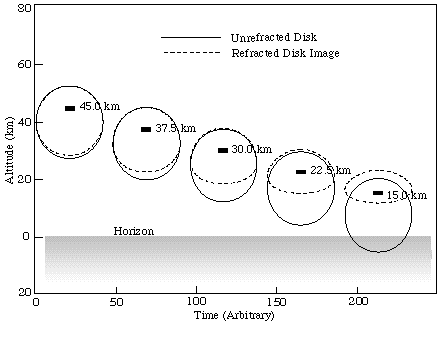
Figure 1.3. Refracted and unrefracted images of the setting sun, with the HALOE IFOV represented by the black rectangle, and tagged with the apparent tangent point altitude. Note that the IFOV is locked (fixed) relative to the top apparent edge of the sun.
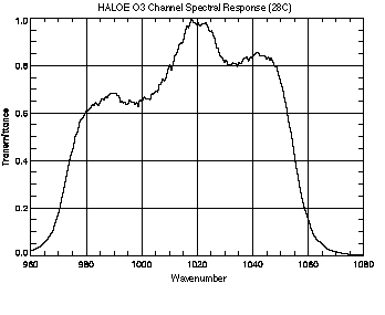
Figure 1.4. The HALOE ozone channel relative spectral response curve at nominal operating temperature of 28°C.
Since HALOE is an occultation experiment, the atmospheric sounding locations depend on spacecraft orbit, rotation of the Earth and the location of the sun. The geometry of the UARS orbit (57° inclination, circular and 600 km) results in 15 sunrises and 15 sunsets daily, with tangent point locations during a day generally confined to small latitude bands which cycle over varying extremes, roughly every 36 days. Figure 1.5 shows the global sunrise and sunset locations for 1995.
The sample rate is 8 Hz which equates to a vertical tangent altitude grid of 0.18 to 0.4 km depending on apparent sun sink rate. This oversamples the effective 2.3 km measurement resolution by a factor of 5 or greater. The data is interpolated to a 0.3 km grid for processing by the retrieval algorithm.
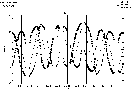
Figure 1.5. The HALOE global sampling pattern for 1995. The o represent the daily mean latitude for the sunrises and the + represents the daily mean latitude for sunsets. There are 15 sunrise and 15 sunset occulations each day, confined to small latitude bands and separated by approximately 24° in longitude.
The individual profile error sources for the HALOE instrument have been well characterised and discussed elsewhere (see Russell et al. (1993), Bruhl et al. (1996), Hervig et al. (1996)). In this section, we describe the main sources of instrument error that affect profiles at lower altitudes (below 50 km), as summarised in Table 1.2.
Pointing uncertainty
The uncertainty in IFOV pointing knowledge is often the dominant source of measurement error in the lower stratosphere and below. For solar occultation, the pointing geometry can be precisely determined from spacecraft location and solar ephemeris data, provided the sun is accurately tracked. The HALOE instrument tracks the top edge of the solar disk image and relies on ephemeris data and an atmospheric refraction model to compute tangent point locations. The onboard closed-loop tracking system maintains (at a 64 Hz sample rate) the IFOV at a fixed angular distance below the solar top edge image to a 16.2 arc second precision, stepping every 1/8 second. This provides a pointing precision of 100 meters or better (at the limb) when combined with oversampling and smoothing over the science measurement time constant of about 1 second. The system has proven extremely reliable at altitudes throughout the stratosphere and mesosphere, inducing random retrieval mixing ratio errors of <3% in clear air.
In regions of heavy aerosol or cirrus clouds, conditions can occur in which the algorithm driving the tracker cannot accurately distinguish the top edge of the sun. When the ozone mixing ratio near the troposphere is extremely small (<0.1 ppm) and the overburden large and steep, percent errors due to pointing can be large with absolute magnitude reaching 0.1 to 0.2 ppm near the 50 to 70 hPa level in the tropics. However, the absolute mixing ratio error reduces to well below these values at lower altitudes in clear air. At mid and high latitudes the precision at tropopause height in clear air can approach 0.01 ppm.
|
|
|
||
|
|
>20 km |
16 - 20 km |
<16 km |
|
|
|
|
|
|
|
|
|
|
|
|
|
|
|
|
|
|
|
|
Table 1.2. The main sources of instrument error that affect HALOE profiles below 20 km, in descending order.
Source Function
HALOE makes exo-atmospheric scans of the sun before sunset and after sunrise events. The scans are measured at high spatial resolution and provide well calibrated source functions. These source functions are also used in the forward signal model to remove the effects of tracking jitter (<100m) which is accurately measured (as discussed above). On occasion, sunspots can be detected in the source functions, although this is an infrequent problem (<5% of events have sunspots large enough to cause significant retrieval error, even early in the mission which was during solar maximum). Because of the orbital geometry, the area of the solar disk viewed above the atmosphere during calibration scans can be slightly different than viewed during occultation. In effect, the solar image appears to rotate, moving into or out of the IFOV. If the sunspot is large enough and positioned near the edge of the IFOV, tracking jitter and/or the apparent solar disk rotation can induce results inconsistent with the modelled source function. The effects are minor in the ozone channel at 10 mm where sunspots are less pronounced, even in times of extreme sunspot activity. The few events that contain significant error due to sunspots are noted in data quality information in the HALOE quality files.
Relative Spectral Response
The spectral response functions of the broadband radiometers are believed to be extremely stable. This is based partly on the analysis of witness filters, which have been found to be stable for over 15 years. Also, peak voltages measured during calibration scans of the sun have been trended since launch to detect any degradation in radiometer response. As of present (over 6 years since launch), the ozone channel has degraded 1.3% in peak value and the CO2 channel <2%. There are indications that these effects are non-spectral, in which case they would have no effect on results. However even spectral filter changes, consistent with these response changes, would have negligible effect on results since the mean atmospheric spectral characteristics for these channels would not change appreciably.
Noise
The on-orbit measured instrument noise for the HALOE O3 channel is of the order of £ 0.00178 Volts. Dividing by the measurement above the atmosphere for the O3 channel (typically 3.2 Volts) gives an attenuation noise value of 0.00056. In the stratosphere, the attenuation signal (1-t) due to a 2.3 km tangent layer gives S/N values greater than 500, which makes instrument noise values insignificant at stratospheric levels and below.
The HALOE processing system converts solar observations during occultations into temperature, pressure, mixing ratio and extinction profiles. The algorithm first uses the measurements, including solar scans, to produce band averaged transmission, t(q), profiles as a function of zenith viewing angle, q, for 8 broadband channels. It also infers transmission difference profiles, Dt(q), for the four bandpasses that have additional gas correlation signals. The next step is registration of the profiles with altitude and pressure by modelling the CO2 channel transmission using temperature and pressure as a function of altitude from an auxiliary data source, NCEP (National Center for Environmental Prediction). These are actually iterative steps since the inferred q depends on calculated refraction effects that alter the apparent location of the solar source image.
Next the retrieval of temperature and pressure above 35 km is performed, using the pressure registration and NCEP temperature at and below 35 km as a lower boundary condition. This is followed by an NO (nitric oxide) mixing ratio retrieval using the NO gas correlation signal divided by the NO broadband signal, Dt/t, which can be shown to be independent of aerosol extinction. Aerosol extinction is then retrieved using the NO mixing ratios and the NO measured broadband t profile. Using Mie theory and index of refraction data for sulphate aerosol, an aerosol extinction profile is modelled for the broadband channels (Hervig 1995). Ozone and water are then retrieved followed by a repeated temperature retrieval that includes aerosol extinction. Next all the above steps, starting with pressure registration using the retrieved temperature instead of NCEP data, are repeated to refine both the pressure and temperature results. Table 1.3. lists the 35 HALOE data processing steps performed for each occultation. The procedure was made sequential for computational efficiency and system simplicity. Simulation determined that this does not compromise accuracy.
Forward Model
The forward models used in the HALOE processing are comprised of subsets of the BANDPAK (Marshall, 1994) and LINEPAK (Gordley, 1994) codes. The gas correlation measurements are simulated by rigorous line-by-line calculations using LINEPAK routines. The broadband measurements are all simulated using BANDPAK routines applying either the CGA (Curtis-Godson Approximation) or PMA (Pseudo Mass Approximation) broadband calculations along with a spectral overlap correction for secondary species, all described in Marshall 1994. The choice of approximation method was determined by accuracy analyses using line-by-line methods.
|
Steps |
|
|
| 1 | t(q) and Dt(q) data | |
| 2, 12 | PR (BBR CO2) |
|
| 3, 11, 13, 21 | t/p (BBR CO2) |
|
| 4, 14, 22 | NO (GCR) |
|
| 5, 15, 19, 23 | AE_NO (BBR) |
|
| 6, 9, 16, 19, 24 | AE_CO2, H2O, NO2, O2 (modelled) | |
| 7, 17, 27 | O3 (BBR) |
|
| 8, 18 | AE_NO (BBR) |
|
| 10, 20, 25 | H2O (BBR) |
|
| 26, 29 | NO2 (BBR) |
|
| 28 | CH4 (GCR) |
|
| 30 | HCl (GCR) |
|
| 31 | HF (GCR) |
|
| 32 | AE_CH4 (BBR) |
|
| 33 | AE_HCl (BBR) |
|
| 34 | AE_HF (BBR) |
|
| 35 | Aerosol parameters (size, number density, composition) determined from 4 individually retrieved extinction profiles |
t(q) transmission profiles as a function of zenith angle
AE_name Aerosol extinction for name bandpass
GCR gas correlation measurement retrieval
BBR broadband measurement retrieval
PMA Pseudo-mass approximation
PR Presssure registration
CGA Curtis-Godson approximation
t/p Temperature and pressure
LBL Line-by-line
Table 1.3. Major HALOE data processing steps.
The HALOE broadband models can be toggled between line-by-line, PMA and CGA. The results in Figure 1.6 are typical of the error in ozone retrievals due to the forward model approximation. In general the retrieved mixing ratio error is in the <3% range above the ozone peak and <5% or <0.2 ppm below the peak, whichever is larger. However, 0.2 ppm error can be a substantial percentage error, but usually only occurs in the tropical lower stratosphere. (See Figure 1.7).
In general, the small mixing ratios in the tropical lower stratosphere are very difficult to retrieve with a high degree of accuracy. The typically steep vertical gradient below a high mixing-ratio peak presents system accuracy requirements difficult to achieve with the current uncertainty in spectral parameters and broadband approximations. This is compounded by the spectral location of the HALOE ozone channel, which was chosen for overall accuracy between tropopause and mesopause. It results in weighting functions for low altitudes that are marginally adequate for tropical tropopause soundings. However, results at mid and high latitudes in clear air are very good down to just above cloud top.
Figure 1.6. Typical mid latitude HALOE ozone retrieval using rigorous line-by-line forward model versus the BANDPAK fast approximation model.
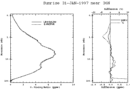
Figure 1.7. Typical low latitude HALOE ozone retrieval using rigorous line-by-line forward model versus the BANDPAK fast approximation model.
The only other significant errors in the forward model are due to spectral parameters. Figure 1.8 shows the effect of a 5% half-width error. The band strength error is now believed by researchers to be about 4% (Flaud, 1990) which results in an equal error in mixing ratio. Under most circumstances a root sum of the squares (rss) of all the forward model error components indicates about a 5% error. At low concentration below large ozone peaks these errors can compound due to weighting function effects discussed above to give a much larger percentage error. However, repeatability in clear air is excellent at all altitudes and latitudes.
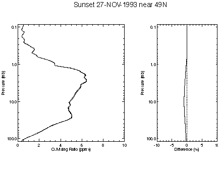
Figure 1.8. Effect of a 5% error in absorption line halfwidth.
The forward model for the CO2 channel is very accurate (<1% error in simulated extinction) at altitudes above 35 km where the temperature/pressure retrieval is performed. Below 35 km the accuracy degrades and NCEP temperatures are used. The broadband transmission of fundamental vibrational bands has only slight temperature dependence, making the temperature uncertainty a small contribution to the total ozone retrieval error which is dominated by ozone forward model error and pointing error below the ozone peak, and random error and forward ozone model error above the peak.
Inverse Model and Retrieval
The inverse model for the HALOE ozone retrieval is a modified onion peel with no a priori assumption. The only assumption is the mixing ratio at the highest retrieved altitude (>90 km), which is made constant with altitude and equal to the top retrieved value. This is achieved by treating the top of the atmosphere as one extended layer. This top boundary condition has less than 5% effect at 85 km and negligible effect below 80 km. An interleave retrieval strategy is applied which uses all the over sampled data at a resolution consistent with the system resolution, achieving profiles that display features very consistent with that resolution. Each transmission profile, sampled at 0.3 km spacing in apparent tangent altitude, is broken into 7 profiles at 2.1 km spacing. These seven are retrieved with independent 2.1 km layer models, re-interlaced into one 0.3 km profile and smoothed with roughly a 1.5 km smoothing function.
The retrieval process proceeds in an onion peel fashion, alternating between the 7 separately modelled profiles using a modified vector relaxation process that effectively weights (in a maximum likelihood fashion) results from nearby (in altitude) points in the other 6 profiles. Three complete passes are performed to eliminate biases introduced from the first pass, which does not have accurate information from results below the tangent point due to the onion peeling sequence.
The combination of precise solar tracking and an instantaneous field of view of 1.6 km leads to very little error due to resolution limitations, part of what is called null space error (Rodgers 1990). The averaging kernels for five different altitudes are shown in Figure 1.9. In reality there is one function per 0.3 km altitude grid point. These functions display how the retrieval weights the true mixing ratio profile to obtain a retrieved value at one altitude. Ideally, for an unconstrained onion peel retrieval, these functions would be symmetric triangular functions about the retrieved altitude. However, a slight constraint to retrieved results at adjacent altitudes, coupled with the natural limb viewing contribution functions (Rodgers 1990), gives slightly asymmetric and oscillating averaging kernels. This has a negligible effect on the error budget, which has been verified by simulated retrievals with no constraint.
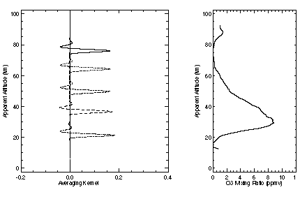
Figure 1.9. Typical HALOE averaging kernels.
Mechanisms causing single event errors are listed in Table 1.4 for a standard mid-latitude profile, along with the order of importance of the five dominant errors for the given altitude range. For a more comprehensive error discussion, consult Bruhl, 1996. As can be seen in the table, the dominant error sources change with altitude. At the lowest altitudes the errors are dominated by pointing and forward model. They can also change with atmospheric state: mixing ratio and temperature profiles, cloud cover, aerosol loading. For clear air and mid-latitude type profiles we list at the bottom of Table 1.4 the current conservative estimates taken from Bruhl, eliminating aerosol and water bias. Water bias is now believed to be insignificant. Aerosol varies with time and must be included only under moderate to extreme conditions. Note that the random error at low altitudes is a small component of the total error.
These traditional single retrieval errors may or may not affect the inference of trends. In trending, random errors become insignificant if large amounts of data are used. Systematic errors such as calibration errors have small effects if stable over time.
Although occultation sensors do not require absolute radiance calibration (only signal ratios are used), as with any spectroscopic technique, stability of spatial and spectral response is essential unless continuously calibrated. In addition the tracking
|
|
|
18-15 km |
|
|
|
| Random | Noise |
1 |
|||
Pointing tracker jitter sunspots |
2 4 |
||||
| Systematic | Forward model | ||||
|
|
|
|
|||
|
|
|
|
|||
|
|
|
||||
|
|
|
|
|||
| Pointing | |||||
|
|
|
|
|||
|
|
|||||
|
|
|||||
| Response functions | |||||
|
|
|||||
| Typical total error % (mid-lat. profiles) |
|
|
|
|
Table 1.4. Relative importance of major HALOE error mechanisms for various altitudes (1 being most important).
requirements for occultation sensors, coupled with solar source function characterisation, present unique problems. Finally, the complicated observation pattern, Earth's oblateness and orbital precession can alias seasonal and latitudinal changes, confusing trend estimates if not done carefully.
Below we discuss mechanisms believed to have a potential impact on trends inferred from HALOE data (and in some cases occultation data in general) and methods used to detect, monitor and estimate the magnitude of these mechanisms. The discussion proceeds by error category with Table 1.5 summarising estimated magnitude.
Aerosol and Cloud Extinction
During the period of large volcanic aerosol loading after the eruption of Pinatubo, the ozone channel transmission at tangent attitudes below 25 km was strongly affected by aerosol extinction. Figure 1.10 shows the effect of aerosol in mid 1992 on the retrieved ozone profile. Figure 1.11 shows the effect in 1997. It was determined, through correlative comparisons that the HALOE processing removes the effects of aerosol with roughly 93% accuracy, or a residual uncertainty equivalent to 7% of the aerosol extinction. This was verified by Steele and Turco (1997). The aerosol error is included in the quality error numbers in the HALOE data set. As can be seen by the two figures, this error can induce a wide range of percentage errors in ozone. From >100% in the lower stratosphere before February 1992 to typically <2% by 1997. Again, the user should check recorded errors in the data set, which are noise plus aerosol effects combined in a root sum squared fashion.
Cloud extinction, which is not spectrally modelled in the current HALOE processing, also can corrupt the broadband signals. Therefore, long-term change in either aerosol or cloud cover could induce trending errors if the affected data are not removed from the analysis. We recommend that trend estimates exclude all data where the aerosol extinction values for the NO channel (5.26 mm) bandpass exceeds 10-4 km-1.
Pointing
As described in section 1.3.4, and shown in Table 1.4, pointing error can be a major low altitude contribution to the total error budget. This is primarily an instrument design limitation that becomes significant just above cloud tops. To induce trend errors, this mechanism also requires a long-term change in aerosol or cloud cover. However, the effect of the problem is eliminated by the same data filtering procedure recommended in the previous section.
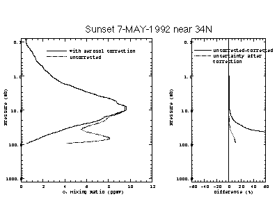
Figure 1.10. Typical HALOE ozone 1992 aerosol correction effects

Figure 1.11. Typical HALOE ozone 1997 aerosol correction effects
Spectral Stability
The spectral response of the HALOE instrument is defined primarily by interference filters, with secondary effects coming from dichroic beam splitters and detectors. The stability of these elements has been evaluated using duplicate witness units. The units, now nearly 15 years old, have shown no measurable change in relative or absolute response. The ozone and CO2 channels use thermistor bolometer detectors which have a long history of reliable use in rugged industrial environments. Duplicate bolometers also show no spectral change.
The spectral filters were manufactured with a lamination process in which small impurities can induce some delamination under extreme (>100 K) thermal cycling. However HALOE experiences less than a 20 K temperature variation in orbit which is not a problem according to the manufacturer. The witness filters were last spectrally scanned in 1996.
Further evidence, from comparisons and solar signal change, and changes of signals from an internal 1000 K blackbody, points to spectral stability.
The only other possible sources of spectral change are the gas cells. However cell content has no direct effect on ozone retrieval. Although the NO gas correlation channel is used to infer aerosol, which is in turn used to correct the ozone channel for aerosol extinction, this procedure is nearly insensitive to gas cell content. Also the cell content for all correlation channels has been proven stable over the mission through an analysis of retrieval correlation with orbital b angle. The overall conclusion is that HALOE has been spectrally stable throughout the mission. Ozone and CO2 signal changes due to relative spectral response, if they exist, must be well below the 1% level.
Time Response
The time response of the measurement system can change the effective resolution due to the sun sink rate. Time response changes can be observed by analysing scans on and off of the sun. No change in response time constant has been observed. A 1% change in resolution can cause up to a 0.05% change in retrieved ozone. We believe resolution has changed less than 2%.
Optical Degradation
Signal characteristics when scanning on and off the sun can also be used to infer off axis scatter and resolution changes. No detectable change has been observed. In addition the gas correlation difference signals give an extremely sensitive response to field-of-view differences (~ 1 ppm) between effective vacuum path and gas cell path signals. There has been no significant change in these signals. Although this is not directly related to the ozone channel, it lends further confidence that the instrument has been optically stable.
Solar Tracking
The tracking system has also shown stable performance. Since the solar source function changes intensity from centre to solar limb (see Figure 1.12), it is essential that the tracking system provide exact field-of-view location on the solar image. Periodically the HALOE instrument makes horizontal scans of the sun to calibrate the tracking system. This ensures that changes in tracking performance are observed and accurately modelled. There has been no observable change in tracking performance. A possible concern is the azimuth tracking stability. As the sun changes shape at low altitudes during an occultation event the ability to centre the FOV changes. As azimuth sensor optics degrade with time, a slight change in centring stability could change results at low altitudes. The flatness of the solar intensity at 9.6 mm greatly reduces this effect relative to the potential liability at shorter wavelengths (again, see Figure 1.12). However, since the NCEP temperatures are used at low altitudes instead of the CO2 2.8 mm signals, the HALOE ozone trends should not be susceptible to small changes in azimuth tracking knowledge.
One change that has been observed is the response of the diodes used for high resolution tracking in the vertical. The total response has decreased by about 30%. Since the tracking logic uses only relative responses of diodes to detect the solar edge, the tracking performance has shown no detectable change, this stability is expected to continue until response is down by 90% or more, which at the current rate of decrease would take another 15 years.
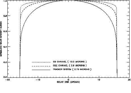
Figure 1.12. Solar intensity curves corresponding to HALOE O3, CO2, and tracker system wavelengths.
Orbital Geometry
The UARS orbit precesses with a period of about 70 days. This causes the occultations to occur at various angles (b angles) relative to the orbital plane, inducing changes in solar image sink rate. The eccentricity of the orbit and the Earth's oblateness also combine to cause a time dependent change in the zenith angle versus height relationship during occultation events that occur at large orbital beta angle. These effects are tedious to model (they can cause up to 25% error in mixing ratio if not included) and are most pronounced at specific latitudes (such as southern mid to high) and seasons. The natural variation in pressure height also contributes more error for large b angles. Each year the sequence of orbital beta angle shifts phase by five days and therefore would shift one full precession cycle of 70 days over 14 years. Although great care has been taken to explicitly incorporate these effects in the data analysis, results for very high b angle (>55o) can often differ by up to 3%. This is expected to have a negligible effect on trend estimation. However trends determined with small subsets of data in specific latitude bands can give degraded results, especially if the mean b angle changes systematically with time. Figure 1.5 shows the 1995 sampling and b angle pattern. The five-day shift each year has the potential of aliasing with seasonal and latitudinal variation. Correlative comparisons at a particular site also have the potential to incur a systematic change in space and time coincidence, leading to false comparison trends. In summary, without careful attention to the sampling details, occultation measurement patterns can lead to biases in trends.
Algorithm
The processing algorithm can be a source of faulty trends if time dependent errors occur. For example the HALOE algorithm assumes a 0.47%/year increase in CO2 mixing ratio. An error in this increase can lead to a nearly equal error in inferred ozone mixing ratios. Another time dependent error that may be quite significant is the aerosol correction. In fact if the data from the first year of the mission is used, the Pinatubo aerosol would likely be the largest contributor to trend error in the lower stratosphere. However, filtering out data through 1992 and other data with large aerosol loading can reduce aerosol-related error to insignificant values. No other mechanisms are known to exist in the processing algorithms that could cause trend errors. The HALOE temperature and pressure retrieval is now independent of auxiliary data above 35 km and therefore not susceptible to errors from those sources. Below 35 km the NCEP temperature is used to build pressure down from the retrieved pressure. The HALOE registration with density at all altitudes is insensitive to NCEP errors, such as height versus pressure relationships.
As discussed above and in section 1.3.4.3, the HALOE instrument has proven very stable over six years of operation. The algorithm uses no a priori other than the upper boundary profile shape, as discussed in section 1.3.5.2. It also uses no time or signal dependent constraint. In addition, high altitude results obtained by retrieving on daily average signal have been found to be nearly identical to results obtained from a daily average retrieval. Considering the extremely noisy character of HALOE retrievals in low S/N at high altitudes, this implies negligible effects due to constraints.
These random characteristics combined with high precision and no requirement for absolute radiance calibration make the data particularly well suited for trending. However the lower stratosphere and upper troposphere trends must be taken from data void of clouds and with little aerosol extinction since the correction for either effect and tracking knowledge can have substantial systematic error components under such conditions.
Table 1.5 lists contributions to trend errors due to instrumental sources only, and does not include errors due to sampling and natural variability. We stress that these are difficult to verify and only best guesses at upper limits. As the mission continues and instrument parameters continue to be monitored, conditions could change.
| Type |
|
|
|
| Aerosol Extinction |
|
|
Assumes pre-1993 data not used |
| CO2 mixing ratio |
|
|
Assumes mixing ratio change over 10 years is known to 0.3% ~ 10 ppm |
| Solar Tracking |
|
|
There is no evidence of change, but likely. |
| Cloud Change |
|
|
There would have to be a change in cloud cover with time |
| Spectral Response |
|
|
No evidence |
| Optical Degradation |
|
|
Assumes 2% FOV widening. No evidence, but likely |
| RSS |
|
|
Assuming clear air (no aerosol) |
|
|
|
Starting with 1993 aerosol |
Table 1.5. Sources of ozone trend error in HALOE measurements, %/year.
Most problems affecting HALOE ozone retrievals above the middle stratosphere are believed to have been solved. Little improvement is expected above 25 km. Below 25 km there has been a substantial effort to understand the tracking performance, which is a major contributor to the error budget. Solutions are now understood and will be implemented in the coming year.
A second major obstacle to achieving optimum results into the upper troposphere is the processing algorithm which was designed to address the stratosphere and above. Substantial information for potential low altitude retrieval of water and methane exists in other channels, which is not being used by the current algorithm. An effort to rectify this deficiency will be funded through NASA. This will lead to improved H2O, CH4, and cirrus detection, and therefore ozone results. A secondary effort under this same grant will be the improvement of the ozone forward model. The eventual goal, expected within 2 to 3 years, is an improved HALOE ozone, water and methane data set below 20 km into the troposphere.
The current data set can be filtered to remove data corrupted by cloud and pointing deficiencies by using an aerosol extinction threshold. This could result in good statistical information, but would still be substantially inferior to the data set expected from the future retrieval strategy that will optimise information extraction at low altitudes using all channels and measurements.
![]()