1. National Institute for Water and Atmospheric Research (NIWA), Lauder, New Zealand
2. Institute for Meteorology and Climate, University of Hanover, Germany
3. Physics Dept., Aristotle University of Thessaloniki, Greece
4. Meteorological Services of Canada (MSC), Toronto, Canada.
5. National Center for Atmospheric Research (NCAR), Boulder Colorado, USA
FIGURES
Abstract
In recent years, estimates of UV radiation at the EarthÕs surface have been obtained from satellite retrievals. These retrievals have been compared with ground-based measurements at a few sites, but so far there have been few comparisons from unpolluted sites. The current study compares differences between satellite-derived estimates of UV and ground-based measurements at a clean air site in the Southern Hemisphere and with more polluted sites in the Northern Hemisphere to investigate the extent to which differences boundary layer extinctions are taken into account by the satellite retrievals. It is found that the hemispheric differences inferred from the ground based measurements are much larger than those derived from the satellite retrievals. Since international intercomparison campaigns have shown the ground based spectroradiometers to be in agreement, it is concluded that differences in tropospheric extinctions (e.g. by ozone and aerosols) are not adequately taken into account in current satellite retrievals of UV radiation.
Introduction
The purpose of the present study is to determine the extent to which differences in tropospheric aerosols can affect the accuracy of satellite-derived UV at mid-latitude sites. This is achieved by comparing daily erythemal UV doses measured at a pristine southern hemisphere site, Lauder New Zealand, with more polluted northern hemisphere sites (Toronto Canada, Garmisch-Partenkirchen Germany, and Thessaloniki Greece).
These sites differ greatly in their aerosol optical depths. The 1 micron aerosol optical depth at Lauder, New Zealand is typically 0.02, whereas in unpolluted regions of the NH, corresponding values of around 0.1 to 0.2 are typically assumed. Other indicators of atmospheric pollution, such as black carbon, and SO2 also differ by a factor of twenty between New Zealand and populated regions of the NH due to differences in anthropogenic contributions.. Model calculations show that these differences can have a large effect on UV irradiance . Observational studies comparing UV between Lauder NZ and Garmish-Partenkirchen have also demonstrated that tropospheric extinctions are an important contributor to the observed differences . For example, measurements revealed the sunburning UV in the New Zealand site to be approximately 40% more than at Garmisch-Partenkirchen.
Differences in surrounding topography can also have an influence on the satellite retrievals because they represent averages over areas of ~30 km x 30 km or more. This is a particular issue with data from Garmisch-Partenkirchen which is surrounded by high mountains. The Lauder site is also affected in this way, but to a lesser extent.
Ground-Based Measurements
Spectral measurements spanning several years are now available with well calibrated UV spectroradiometers from several sites.
Data from the groups responsible for data at the sites in Table 1 have been intercompared though an International effort to standardise ultraviolet spectroradiometry for a European Network (the SUSPEN intercomparison campaign in Greece in July 1997) and have been found to agree to within 2-3 % when corrections are applied to account for errors in the cosine response of the instruments . Data from the contributing groups were normalised to a common scale using the correction factors derived from this intercomparison campaign [Bais et al., 2000] and were provided in the form of daily doses of erythemally weighted UV irradiances [McKinlay and Diffey, 1987]. Measurements from the Brewer instruments (Greece and Canada) included small corrections to allow for the contribution to erythemal UV from wavelengths longer than the sampled region.
| Site/ Country |
Lat |
Long |
Alt (m) |
Mean Pressure (hPa) |
Normalised correction (from SUSPEN) |
Laboratory |
| Toronto,
Canada |
43.78 |
-79.47 |
198 |
995? |
1.03 |
Met Service Canada |
| Thessaloniki,
Greece |
40.52 |
22.97 |
50 |
1013 |
1.01 |
Aristotle University |
| Garmisch-Partenkirchen,
Germany |
47.48 |
11.07 |
730 |
930 |
0.99 |
IFU |
| Lauder,
New Zealand |
-45.04 |
169.68 |
370 |
980 |
1.00 |
NIWA |
Table 1. Details of measurement sites
TOMS Satellite Data
Satellite overpass data was made available from TOMS instruments on NIMBUS-7 and from EARTH-PROBE satellites. The periods analysed and satellite footprint dimensions are listed in Table 2.
|
TOMS Satellite |
Start Date |
End Date |
Footprint minimum to maximum dimensions (km x km) |
|
NIMBUS-7 |
Day 305, 1978 |
Day 126, 1993 |
(50 x 50) to (150 x 100) |
|
EARTH-PROBE |
Day 198, 1996 |
Day 50, 2000 |
(26 x 26) to (60 x 33) to Dec 1997 (38 x 38) to (99 x 52) from Dec 1997 |
Table 2. Details of satellite-derived UV estimates
Comparisons with Daily Overpass Data
The collocated satellite overpass data were merged with cross-calibrated ground based data from the four sites.
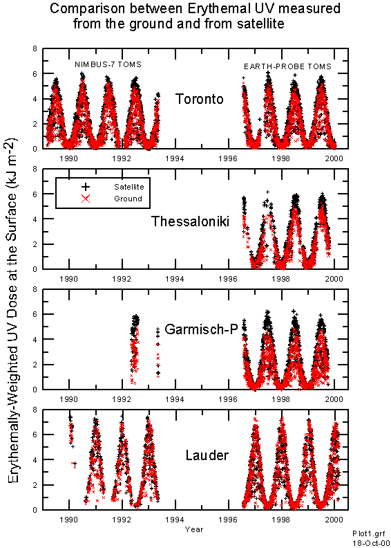
Figure 1 shows the period of coverage, and compares the daily does of erythemally weighted UV. Doses are greatest at Lauder, and while there is good agreement between satellite derived UV dose and measured UV dose at Lauder New Zealand, at the Northern Hemisphere sites the measured doses are significantly less than those retrieved from the satellites.
Figure 1. Comparison between satelite-derived erythemal UV and ground based measurements.
Figures 2 shows detailed day to day variations over shorter periods during the summer. The satellite-derived UV shows a remarkable ability to model the effects of cloud changes in daily integrated UV dose from a single observation per day. However, there can be notable outliers.
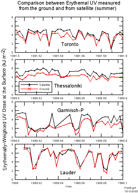
Figure 2 Comparison between satelite-derived erythemal UV and ground based measurements over a summer period.
Figure 3 shows scatter plots of satellite-derived erythemal UV versus measured values for the four sites. Despite the similarity in latitude, the measured doses for Lauder are much greater than at the other three sites. Again the systematic differences noted previously can be seen. Differences between satellite-derived UV and measured UV can be large. The spread of deviations is noticeably smaller for Thessaloniki. It appears that day to day cloud effects may be smaller here. This is also the only region which remains snow free all year round.
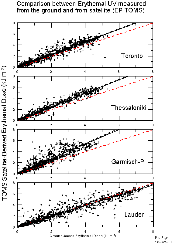
Figure 3. Scatter plot of TOMS-derived erythemal UV dose versus ground based measurement. The red line is the ideal. The dotted black line is the regression through the origin, and the solid black line is the best fit linear regression.
The Lauder site appears to show greater variability from day to day which is not always captured by the satellite data. This may be because of peculiarities of the measurement site which is located in a valley with very low rainfall, but with regions of much heavier rainfall surrounding the site (especially to the West). While at some sites, the fractional cloud cover in a satellite image may be an accurate representation of the average cloud cover over a particular site within the scene, this is not the case in Lauder.
We investigated the sensitivity of the regressions as functions of the parameters available in the TOMS overpass data (e.g. SO2 index, ozone, aerosol index, reflectivity, sza, surface pressure, collocation error). Generally the sensitivities were small. However, the error between satellite-derived and ground-measured UV did show a possible dependence on satellite footprint pressure. At Lauder there is a suggestion that errors are larger at lower pressures. There are two possible causes for this:
Histograms of the satellite footprint surface pressure are shown in Figure 4. They show that at Garmisch-Partenkirchen there is a wide range of pressure differences and the mean surface pressure is approximately 60 mb less than at the observatory mean pressure of 930 mb. This corresponds to altitude discrepancy of ~300 m, which could be responsible for systematic differences in UV of a few percent, since in Europe, altitude sensitivities of ~20 percent per kilometre have been reported [Blumthaler et al., 1997; Seckmeyer et al., 1997]. However it had been shown that the dependence on altitude cannot be described by a single number, but is a function of season, albedo and air pollution [Seckmeyer et al., 1997]. Similar differences in pressure are observed at Lauder, but since aerosol extinctions are small at this site, we can be more confident that the altitude difference does not lead to a significant error. At Toronto and Thessaloniki, the pressure differences are small. At all sites, the pressure differences show little sensitivity to these selection criteria.
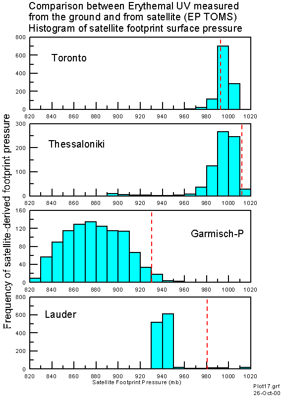
Figure 4. Histogram of satellite footprint pressure. The dotted vertical red lines represent the mean station pressure at each site.
Constraining Acceptance Criteria
The analysis above uses all of the overpass data supplied, for which the maximum separations sometimes exceed 300 km. In some regions a 300 km radius represents a wide range in climate regimes, so the analysis was also repeated with more stringent acceptance limits (Table 3).
| Measurement Site |
Subset of Overpass data |
No of days |
Correlation Coeff (R2) |
Regression Gradient |
| Toronto, Canada | All 100km 50km 10km 50 km, z>45 50 km, r<20 50 km, z<45 50 km, z<45,r<20 50 km, z>45,r<20 |
1125 |
0.974 |
1.166 |
| Thessaloniki, Greece | All 100 km 50 km 10 km 50 km, z>45 50 km, r<20 50 km, z<45 50 km, z<45,r<20 50 km, z>45,r<20 |
738 |
0.984 |
1.248 |
| Garmisch-Partenkirchen, Germany | All 100 km 50 km 10 km 50 km, z>45 50 km, r<20 50 km, z<45 50 km, z<45,r<20 50 km, z>45,r<20 |
1013 |
0.936 |
1.376 |
| Lauder, New Zealand | All 100 km 50 km 10 km 50 km, z>45 50 km, r<20 50 km, z<45 50 km, z<45,r<20 50 km, z>45,r<20 |
1209 |
0.962 |
0.977 |
Table 3. Effect on statistics of changing the co-incidence criteria for TOMS E-P data. The criterion z>45 corresponds to data selected at sza > 45, corresponding to winter data, whereas, z<45 corresponds to summer data. The criterion r<20 corresponds to selecting only data with reflectivity less than 20% to avoid complications of overcast conditions, or snow-covered terrain. There were no significant changes in satellite footprint pressure when using different selection criteria.
As the selection criteria are tightened, the number of points included decreases and the correlation coefficients increase as expected. While at most sites the relationship between satellite-derived UV and measured UV is relatively e these selection criteria. The largest differences occur at Garmisch-Partenkirchen, where the gradients are smaller during the winter months (sza > 45), or for cloud and snow free conditions (reflectivities < 20). It appears that at this site the high surrounding terrain contributes significantly to the deviations. However, at the other sites, errors arising from these selection criteria are not important.
Relationship between Satellite Deviations and aerosol optical depth
The satellite-derived UV is not a direct measurement of UV at the surface. It is a product derived from a radiative transfer model, using UV radiation which is backscattered from the troposphere. Because the radiation does not penetrate fully through the boundary layer, there is a potential for the satellite product to overestimate UV, particularly in regions where aerosol and tropospheric ozone concentrations are greater so that the effective backscatter altitude is higher. The effect of this can be appreciable: Kylling et al., [1998] have shown that aerosols in Greece we can easily reduce the erythemal UV by 20% or even more; Mayer [1997] has shown that at Garmisch-Partenkirchen, aerosol reductions in global UV irradiance are typically 10%. The satellite deviations appear to be correlated to differences in 340 nm aerosol optical depths which are small at Lauder (0.03 in winter and 0.05 in summer ), but much larger at Thessaloniki (0.4 in winter to 0.5 in summer) and Toronto (0.25 in winter to 0.36 in summer).
At Garmisch-Partenkirchen, the situation is more complex. The 340 nm optical depths are intermediate (0.15) at this site, but the surrounding high terrain leads to a further overestimation of the satellite derived product. Although to the restricted horizons also reduce the field of view of the ground-based instrument, this effect is smaller than 2% as long as the direct sun is not obscured by the mountains. Measurements of optical depth in surrounding regions [Ingold et al., 2000] also suggest that those derived for Garmisch-Partenkirchen [Mayer, 1997] may be too small.
At Lauder, although the altitude errors are nearly as large, their effect is less important because of the low aerosol optical depths. It should also be noted that the satellite-derived ozone amounts are systematically more than ground-based measurements as this site [Bodeker et al., 2000]. The use of these larger ozone amounts tends to decrease the inferred UV (by up to 5%) and thus tend to cancel the errors due to altitude differences. However, it could be speculated that the agreement between satellite derived UV and ground-based measurments may still be fortuitous since the refelctances (e.g. from clouds and snow) over the measurement site are not typical of those over the satellite footprint. Typically, the reflectivity at Lauder is lower since it is snow free and less cloudy [Uddstrom et al., 2000]. The overestimated reflectivity from the satellite leads to reductions in the deduced UV. If these reductions were as large as 20%, the discrepancies at Lauder would then have been similar to those at the other sites.
Based on these intercomparisons we conclude that while the TOMS retrievals are in good agreement with ground based measurements at the pristine site in Lauder NZ, they systematically overestimate the UV doses in more polluted locations. Measurements from the two sites in Europe are 20-30% less than the satellite derived values, while measurements in Toronto are approximately 15% less than the satellite derived values. These findings are consistent with previously reported results from the as discussed previously .
Conclusions
A more detailed analysis of this data set is in preparation, and will be submitted for publication [McKenzie et al., 2000]
Acknowledgements: We thank Jay Herman and Ed Celarier at NASA Goddard Space Flight Center for providing the TOMS overpass data used in this study. For quality control of the ground-based data sets we thank Mike Kotkamp (Lauder), Tim Martin (Garmisch-Partenkirchen), Tom Grajnar and Vitali Fioletov (Toronto).
References
Bais, A. F., B. G. Gardiner, H. Slaper, M. Blumthaler, G. Bernhard, R. L. McKenzie, A. R. Webb, G. Seckmeyer, B. Kjeldstad, et al., The SUSPEN intercomparison of ultraviolet spectroradiometers, J. Geophys. Res., 2000, in press, 2000.
Blumthaler, M., W. Ambach, and R. Ellinger, Increase in solar UV radiation with altitude, Journal of Photochemistry and Biology B: Biology, 39, 130-134, 1997.
Bodeker, G.E., J.C. Scott, and K. Kreher, Global ozone trends in potential vorticity coordinates using TOMS and GOME intercompared against the Dobson network: 1978-1998, Journal of Geophysical Research, 2000 submitted March.
Charlson, R. J., J. Langner, H. Rodhe, C. B. Leovy, and S. G. Warren, Perturbation of the northern hemisphere radiative balance by backscattering from anthropogenic sulfate aerosols, Tellus, 43AB, 152-163, 1991.
Cooke, W. F., and J. J. N. Wilson, A global black carbon model, J. Geophys. Res., 101, 19395-19409, 1996.
Erlick, C., and J. E. Frederick, Effects of aerosols on the wavelength dependence of atmospheric transmission in the ultraviolet and visible 1.A "single-scattering-separate" delta-Eddington model, J. Geophys. Res., 103, 11465-11472, 1998a.
Erlick, C., and J. E. Frederick, Effects of aerosols on the wavelength dependence of atmospheric transmission in the ultraviolet and visible 2. Continental and urban aerosols in clear skies, J. Geophys. Res., 103, 23,275-23,285, 1998b.
Gardiner, B. G., and P. J. Kirsch, Intercomparison of ultraviolet spectroradiometers Nea Michaniona, 4-5 July 1997, Rep. ENV4-CT95-0056, 52 + figures pp., 1998.
Gonzales, C. R., J. P. Veefkind, and G. de Leeuw, Aerosol optical depth over Europe in August 1997 derived from ATSR-2 data, Geophys. Res. Lett., 27, 955-958, 2000.
Herman, J.R., N. Krotkov, E. Celarier, D. Larko, and G. Labow, Distribution of UV radiation at the Earth's surface using TOMS-measured UV-backscattered radiances, Journal of Geophysical Research, 104, D10, 12,059-12,076, 1999.
Ingold, T., C. Mätzler, N. Kämpfer, and A. Heimo, Aerosol optical depth measurements by means of a sun-photometer network in Switzerland, J. Geophys. Res., 2000, submitted.
Kalliskota, S., J. Kaurola, P. Taalas, J. Herman, E. A. Celarier, and N. A. Krotkov, Comparison of daily does estimated from NIMBUS 7/TOMS measurements and ground-based spectroradiometric data, J. Geophys. Res., 105, 5059-5067, 2000.
Kylling, A., A.F. Bais, M. Blumthaler, J. Schreder, and C.S. Zerefos, Effect of aerosols on solar UV irradiances during the Photochemical Activity and Solar Ultraviolet Radiation campaign, J. Geophys. Res., 103, D20, 26,051-26,060, 1998.
Langner, J., and H. Rodhe, A global three-dimensional model of the tropospheric sulphur cycle, J. Atmos. Chem., 13, 225-263, 1991.
Li, Z., P. Wang, and J. Cihlar, A simple and efficient method for retrieving surface UV radiation dose rate from satellite, J. Geophys. Res., 105, 5027-5036, 2000.
Lubin, D., E. H. Jensen, and H. P. Gies, Global surface ultraviolet radiation climatology from TOMS and ERBE data, J. Geophys. Res., 103, 26,061-26,091, 1998.
Martin T., Gardiner B., Seckmeyer G.: Uncertainties in satellite-derived esitmates of surface UV doses, Journal of Geophysical Research, 2000, in press
Mayer, B., Messung und Modellierung der spektralen Bestrahlungsstaerke in Garmisch-Partenkirchen, PhD thesis, Universitat Ilmenau, 1997.
Mayer, B., A. Kylling, S. Madronich, and G. Seckmeyer, Enhanced absorption of UV irradiance due to multiple scattering in clouds: experimental evidence and theoretical explanation., J. Geophys.Res., 103 D23, 31,241, 1998.
McKenzie, R. L., M. Kotkamp, G. Seckmeyer, R. Erb, R. Gies, and S. Toomey, First southern hemisphere intercomparison of measured solar UV spectra, Geophys. Res. Lett., 20, 2223-2226, 1993.
McKenzie, R.L., G. Seckmeyer, A. Bais, and S. Madronich, Satellite retrievals of Erythemal UV dose compared with ground-based measurements at Northern and Southern mid-latitudes, Journal of Geophysical Research, 2000, in prep.
McKinlay, A.F., and B.L. Diffey, A Reference Action Spectrum for Ultra-violet Induced Erythema in Human Skin, in Human Exposure to Ultraviolet Radiation: Risks and Regulations, edited by W.F. Passchier, and B.F.M. Bosnajakovic, pp. 83-87, Elsevier, Amsterdam, 1987.
Schult, I., J. Feichter, and W. F. Cooke, Effect of black carbon and sulfate aerosols on the global radiation budget, J. Geophys. Res., 102, 30,107-30,117, 1997.
Seckmeyer, G., B. Mayer, G. Bernhard, R. Erb, A. Albold, H. Jäger, and W.R. Stockwell, New maximum UV irradiance levels observed in Central Europe, Atmospheric Environment, 31, 2971-2976, 1997.
Seckmeyer, G., and R. L. McKenzie, Increased ultraviolet radiation in New Zealand (45°S) relative to Germany (48°N), Nature, 359, 135-137, 1992.
Verdebout, J., A method to generate surface UV radiation maps over Europe using GOME, Meteosat, and ancillary geophysical data, J. Geophys. Res., 105, 5049-5058, 2000.
Wang, P., Z. Li, J. Cihlar, D. I. Wardle, and J. Kerr, Validation of an UV inversion algorithm using satellite and surface measurements, J. Geophys. Res., 105, 5037-5048, 2000.
Back to
| Session 1 : Stratospheric Processes and their Role in Climate | Session 2 : Stratospheric Indicators of Climate Change |
| Session 3 : Modelling and Diagnosis of Stratospheric Effects on Climate | Session 4 : UV Observations and Modelling |
| AuthorData | |
| Home Page | |