Previous: Introduction Next:Contribution of Waves Up: Ext. Abst.
2. Characteristic Ozone Profiles
The atmospheric conditions near the tropopause region have been compared at Singapore and San Cristóbal by analyzing the operational rawin sonde data.
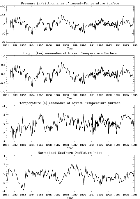
Figure 2 shows the time series of the monthly mean values of (top) pressure, (second) height, and (third) temperature of the cold point tropopause (the atmospheric region where vertical profile of temperature shows minimum) at Singapore (thin lines) and San Cristóbal (heavy lines), while the bottom panel shows the deseasonalized and normalized Southern Oscillation Index (SOI). It is readily seen that the temperature and the height of the tropopause are almost synchronized between the two stations and do not exhibit direct correspondence with the time evolution of El Niño indexed by SOI. These evidences, as opposed to the general expectation of the strong influence of the SST variation on the tropopause properties, suggest that the tropospheric dynamical forcing is not a prevailing factor that drives the interannual variation of the tropopause properties (Hasebe and Koyata, 2001).
Low concentrations of ozone (less than 10 ppbv) in the upper troposphere, which were frequently observed in the western tropical Pacific (Vömel et al., 1995), have not been encountered in the central to the eastern tropical Pacific even during the intense El Niño period. The vertical profiles of temperature, partial pressure of ozone, zonal wind and meridional wind over San Cristóbal averaged during the campaign are shown in Figure 3 for March-April of 1998 (black) and September of 1998 (red).
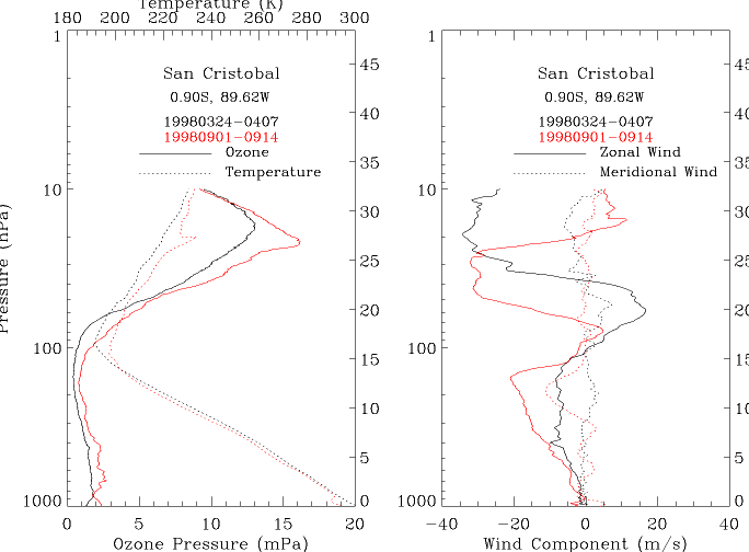
Figure 3
The former and the latter periods correspond to the local rainy season intensified by El Niño and the dry season strengthened by La Niña, respectively. Tropospheric temperature is higher and the tropopause is located at higher altitude in the former period corresponding to the thermal forcing from the lower boundary and the stronger pumping from the Northern mid and high latitudes. Tropospheric ozone amounts are smaller in wet than in dry season in San Cristóbal due probably to the active pumping of ozone poor surface air to the middle and upper troposphere in the former period. As shown later in Figure 5, long range transport of ozone and its precursors from South American continent in the latter season also contributes to the build-up of tropospheric ozone. The upward displacement of the tropopause also play some role in the reduction of total ozone. Other features worth mentioning here are the existence of a clear temperature inversion at the top of the marine boundary layer in the latter campaign period and the strong influence of the QBO in the stratospheric portion, where the ozone takes maximum around the westerly shear zone simultaneously with temperature.
The search for the origin of the air mass observed at each sounding is useful to understand the vertical profile of the trace species. Isentropic back trajectories reaching three SOWER/Pacific stations have been calculated both from statistical point of view and specific for event-by-event basis. They show characteristic features representing the surface inflow to the ITCZ, the upper level outflow from it, and the lower side branch of the Walker cell modulated by the seasonal march and ENSO event. The upper tropospheric trajectories are frequently originated from midlatitudes branching out from the subtropical jet stream. Thus it is expected that varieties of air parcels are observed depending on the altitude, season and locations. Two examples of such trajectories are shown in Figures 4 and 5, where the left panel shows temperature (dashed line), ozone mixing ratio (solid line), and relative humidity (dotted line) profiles and the right illustrates the seven-day isentropic back trajectories corresponding to the colored portion in the ozone profile.
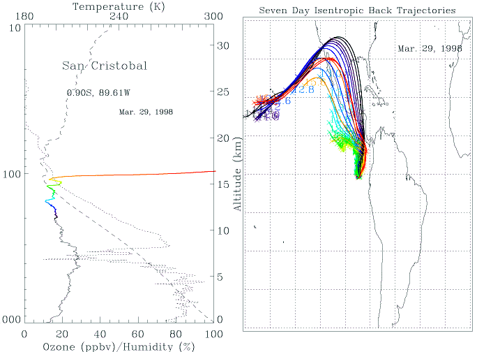
Figure 4 is an example from March 1998 that corresponds to the rainy season intensified by El Niño. The ozone values in the upper troposphere is the record lowest for San Cristóbal but do not reach less than 10 ppbv. The trajectories originated from those altitude range with minimum ozone mixing ratio (green and yellow) are coming from nearby region over the ocean where active convections are suggested from the GOES 8 infrared data, while those below and above this region are connected to Northern midlatitudes.
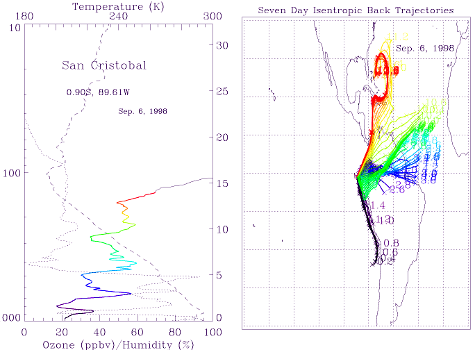
Another example in Figure 5 shows a typical profile in September, where there appears a layered structure in the troposphere both in ozone and relative humidity with a clear out-of-phase relationship between the two. In the marine boundary layer below the temperature inversion, the ozone shows minima and the trajectories indicate the air mass flowing along the west coast of Chile. This suggests the possibility of the chemical ozone destruction by methyl halide along the transport, although we have no direct measurements of such species. The ozone maximum around 3 km corresponds to the trajectories coming from the Amazonia probably influenced by biomass burning. The origin of trajectories in the upper troposphere swing to Northern midlatitudes, where the air mass shows the upper-level out-flow from convective system over Bahamas
Previous: Introduction Next:Contribution of Waves Up: Ext. Abst.