1 Ibaraki University, Japan
2Hokkaido University, Japan
3NOAA/CMDL, U.S.A.
4Kyoto University, Japan
5INAMHI, Ecuador
FIGURES
Abstract
Soundings of Ozone and Water in the Equatorial Region/Pacific
Mission (SOWER/Pacific) is initiated to improve our understanding
on the distribution and variations of the ozone and water vapor
in the stratosphere and troposphere of the equatorial Pacific.
The mechanism of mass exchange across the tropical tropopause,
the chemical ozone depletion due to biogenic halogen compounds
in the tropical eastern Pacific, the climatology of the ozone
profile in the tropics are some of those subjects included in
the scope of SOWER/Pacific.
What is specific is that SOWER/Pacific is trying to have coordinated,
year-round ozone and water vapor soundings on a scale across the
Pacific paying special attention to the east-west contrast along
the equator. The base stations are San Cristóbal, Galápagos in
Ecuador (0.90ºS, 89.62ºW), Christmas Island of Republic of Kiribati
(2.00ºN, 157.38ºW), and Watukosek in Indonesia (7.57ºS, 112.63ºE).
The spatial gaps between these stations will be filled by sondes
launched from research vessels cruising the central to the eastern
Pacific.
Due to the limited fund available, the initial effort has been
to undertake spontaneous campaign observations under two extreme
atmospheric conditions; the boreal winter (summer) when tropical
tropopause is cold (warm) and high (low) reflecting the extratropical
pumping activity in the Northern middle and high latitudes. The
two periods also correspond to the local rainy season and dry
season, respectively. What was unexpected, the record strong El
Niño took place in 1997-1998 switching quickly to La Niña in the
latter half of 1998. This paper presents some of the important
findings on the tropospheric ozone distributions and the water
vapor budget in the lower stratosphere obtained from the campaign
observations in Galápagos and Christmas Island from 1998 to 2000.
1. Introduction
Total ozone variations in the equatorial region are characterized by the annual cycle, quasi-biennial oscillation (QBO), and those related to El Niño/Southern Oscillation (ENSO) (Shiotani, 1992). The annual maxima take place around August-September period, while the minima are observed in Northern winter. The zonal structure is known to show persistent wave one pattern with the phase of minima located around the date line. The QBO is characterized by zonally uniform variations, while ENSO component has both zonally symmetric and zonal wave components (Shiotani and Hasebe, 1994). Due to lack of observational data, however, the contribution of the tropospheric ozone to these features and those variations at the vicinity of tropopause are not yet well described, making it hard to understand even the fundamental processes responsible for those variations.
Tropical Pacific is characterized by east-west contrast both in dynamical and chemical point of view. Prevailing easterly wind near surface brings about marked contrast in the sea surface temperature (SST) distributions along the equator. In the western Pacific where SST is high, the tropopause is higher and colder than any other places in the world and the ozone poor surface air could be quickly pumped up to the upper troposphere by active convections. Release of nitrogen oxides from biomass burning is intensified during El Niño leading to an enhancement of the ozone concentration in the troposphere. On the other hand, the cold upwelling in the eastern Pacific provides ideal condition to nurture marine algae and biologically produced methyl halide may effectively destroy surface ozone while air in the marine boundary layer is trapped close to the surface due to strong temperature inversion over the cold sea.
The Soundings of Ozone and Water in the Equatorial Region/Pacific Mission (SOWER/Pacific) is intended to improve our knowledge on the ozone and water vapor distributions by making coordinated radio sonde observations in the Pacific region along the equator (SOWER Project, 1998). What is unique in SOWER/Pacific is that it is trying to make organized ozone and water vapor sonde observations together with GPS sonde soundings simultaneously at stations in the eastern, central, and western tropical Pacific.
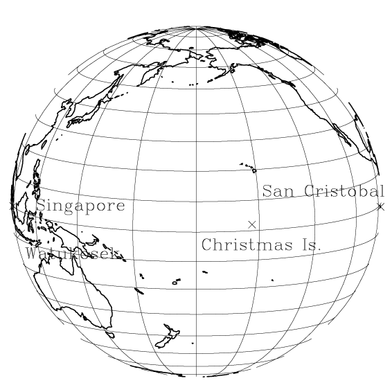
Figure 1 shows the location of the three SOWER/Pacific stations, namely San Cristóbal, Galápagos in Ecuador (0.90ºS, 89.62ºW), Christmas Island of Republic of Kiribati (2.00ºN, 157.38ºW), and Watukosek in Indonesia (7.57ºS, 112.63ºE). The operational rawin sonde data at Singapore (1.37ºN, 103.98ºE) are also used. Due to limited fund available, the observations have been started as a basis of campaigns, the first of which was realized in March 1998 (Hasebe et al., 1998; 1999). Since then, roughly two-week long campaigns have been conducted repeatedly in the period of February-March and September-October to capture the atmospheric behavior during local rainy/dry seasons and strong/weak pumping from the extratropical stratosphere. Efforts have been made to fill the spatial gaps between these stations by launching sondes from a cruising research vessel (Shiotani et al., 2000a).
In addition to establishing the climatology and variabilities in ozone and water vapor, it is also intended to explore the atmospheric processes related to the troposphere-stratosphere exchange. Collection of correlative data for satellite validation is also within the scope of SOWER/Pacific.
This paper briefly describes an overview of the SOWER/Pacific 1998-2000 campaigns. During this period, ENSO status changed quickly from the final phase of the intense El Niño in March 1998 to La Niña in September 1998 and stayed in this side with short period of neutral condition. Some of the issues could be found also in Hasebe et al. (2000), Fujiwara and Takahashi (2000), Oltmans et al. (2000), Shiotani et al. (2000b), and Vömel et al. (2000).
2. Characteristic Ozone Profiles
The atmospheric conditions near the tropopause region have been compared at Singapore and San Cristóbal by analyzing the operational rawin sonde data.
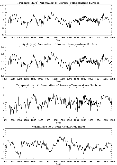
Figure 2 shows the time series of the monthly mean values of (top) pressure, (second) height, and (third) temperature of the cold point tropopause (the atmospheric region where vertical profile of temperature shows minimum) at Singapore (thin lines) and San Cristóbal (heavy lines), while the bottom panel shows the deseasonalized and normalized Southern Oscillation Index (SOI). It is readily seen that the temperature and the height of the tropopause are almost synchronized between the two stations and do not exhibit direct correspondence with the time evolution of El Niño indexed by SOI. These evidences, as opposed to the general expectation of the strong influence of the SST variation on the tropopause properties, suggest that the tropospheric dynamical forcing is not a prevailing factor that drives the interannual variation of the tropopause properties (Hasebe and Koyata, 2001).
Low concentrations of ozone (less than 10 ppbv) in the upper troposphere, which were frequently observed in the western tropical Pacific (Vömel et al., 1995), have not been encountered in the central to the eastern tropical Pacific even during the intense El Niño period. The vertical profiles of temperature, partial pressure of ozone, zonal wind and meridional wind over San Cristóbal averaged during the campaign are shown in Figure 3 for March-April of 1998 (black) and September of 1998 (red).
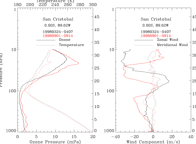
Figure 3
The former and the latter periods correspond to the local rainy season intensified by El Niño and the dry season strengthened by La Niña, respectively. Tropospheric temperature is higher and the tropopause is located at higher altitude in the former period corresponding to the thermal forcing from the lower boundary and the stronger pumping from the Northern mid and high latitudes. Tropospheric ozone amounts are smaller in wet than in dry season in San Cristóbal due probably to the active pumping of ozone poor surface air to the middle and upper troposphere in the former period. As shown later in Figure 5, long range transport of ozone and its precursors from South American continent in the latter season also contributes to the build-up of tropospheric ozone. The upward displacement of the tropopause also play some role in the reduction of total ozone. Other features worth mentioning here are the existence of a clear temperature inversion at the top of the marine boundary layer in the latter campaign period and the strong influence of the QBO in the stratospheric portion, where the ozone takes maximum around the westerly shear zone simultaneously with temperature.
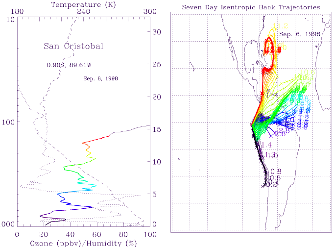
The search for the origin of the air mass observed at each sounding is useful to understand the vertical profile of the trace species. Isentropic back trajectories reaching three SOWER/Pacific stations have been calculated both from statistical point of view and specific for event-by-event basis. They show characteristic features representing the surface inflow to the ITCZ, the upper level outflow from it, and the lower side branch of the Walker cell modulated by the seasonal march and ENSO event. The upper tropospheric trajectories are frequently originated from midlatitudes branching out from the subtropical jet stream. Thus it is expected that varieties of air parcels are observed depending on the altitude, season and locations. Two examples of such trajectories are shown in Figures 4 and 5, where the left panel shows temperature (dashed line), ozone mixing ratio (solid line), and relative humidity (dotted line) profiles and the right illustrates the seven-day isentropic back trajectories corresponding to the colored portion in the ozone profile.
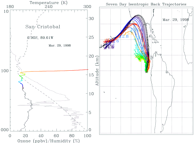
Figure 4 is an example from March 1998 that corresponds to the rainy season intensified by El Niño. The ozone values in the upper troposphere is the record lowest for San Cristóbal but do not reach less than 10 ppbv. The trajectories originated from those altitude range with minimum ozone mixing ratio (green and yellow) are coming from nearby region over the ocean where active convections are suggested from the GOES 8 infrared data, while those below and above this region are connected to Northern midlatitudes.
Another example in Figure 5 shows a typical profile in September, where there appears a layered structure in the troposphere both in ozone and relative humidity with a clear out-of-phase relationship between the two. In the marine boundary layer below the temperature inversion, the ozone shows minima and the trajectories indicate the air mass flowing along the west coast of Chile. This suggests the possibility of the chemical ozone destruction by methyl halide along the transport, although we have no direct measurements of such species. The ozone maximum around 3 km corresponds to the trajectories coming from the Amazonia probably influenced by biomass burning. The origin of trajectories in the upper troposphere swing to Northern midlatitudes, where the air mass shows the upper-level out-flow from convective system over Bahamas
3. Contribution of Waves
Vertically propagating atmospheric waves are commonly observed in the time evolution of daily radio sound data in the tropical stations. The perturbations in the tropospheric temperature and wind, supposed to be driven by atmospheric waves, are found to be more pronounced over San Cristóbal than in Singapore (Hasebe and Koyata, 2001).
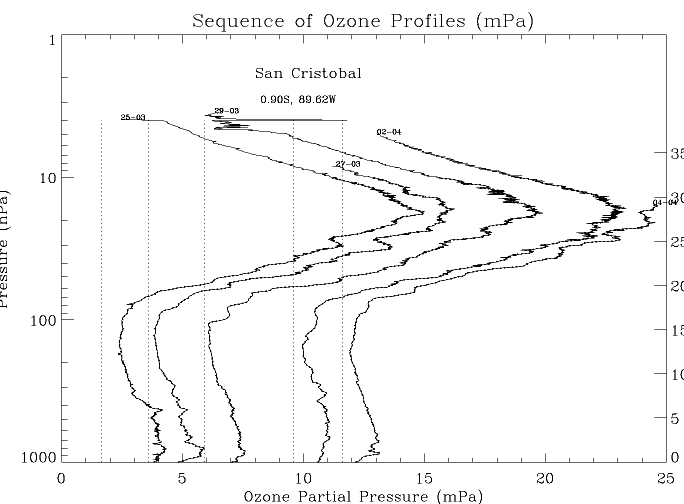
Figure 6 shows an example of such waves in San Cristóbal illustrated in the form of the sequence of ozone profiles shifted to the right hand side of the diagram corresponding to the day of observations.
It is readily seen that the ozone concentrations show wavy structure
in the vertical direction with the wavelength around one or two
kilometers. We could see the downward phase propagation of these
waves with the phase speed of about one kilometer per three days,
corresponding to the typical time scale of several days. Similar
features are also seen in potential temperature and ozone mixing
ratio both of which are pseudo conservative quantities during
the adiabatic processes associated with the wave perturbations.
When the phase of the waves reaches the tropopause, the wave structure
decays due probably to the mixing in the troposphere. Thus the
process is irreversible, representing the net downward transport
of stratospheric ozone into the troposphere. Although what we
see here would be those by gravity waves, similar processes have
been noted by Tsuda et al. (1994) and Fujiwara et al. (1998) in
the case of Kelvin waves observed over Indonesia.
What is interesting here is the role of these waves on the transport of water vapor. While the vertical gradient of the ozone is positive in the lower stratosphere, that of the water vapor is negative in the upper troposphere. This means that the similar process will bring about the negative transport of water vapor from the stratosphere to the troposphere.
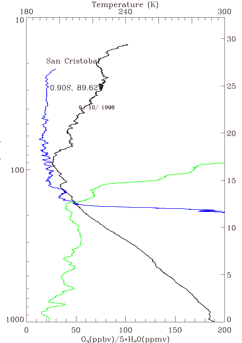
Figure 7 shows a typical profile of temperature (black), ozone (green)
and water vapor mixing ratio (blue) over San Cristóbal. It is
readily seen that the wave structure of the water vapor is out-of-phase
with that of the ozone and temperature in the region between 100
and 200 hPa. Such kind of waves are expected to work to pump the
humid air mass out from the lower stratosphere thus contributing
to keep the lower stratosphere dry as if it were a "stratospheric
draining pump."
Although the evidences shown above indicate the role of waves in small time- and vertical scales, Kelvin waves such as observed by Fujiwara et al. (1998) with larger scales may play more important role.
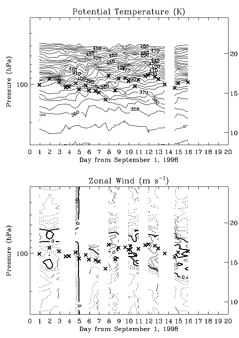
Figure 8 illustrates the time-height section of (top) potential temperature and (bottom) zonal wind during the September 1998 campaign at San Cristóbal. The crosses mark the location of the cold point tropopause.
The upward jump of the tropopause is observed at September 8, and the region of relatively high potential temperature is seen descending between the tropopause gap at a rate of about 4 km per ten days. This region corresponds to the westerly shear zone that divide the tropospheric easterlies from the lower-stratospheric westerlies. There is no systematic variation associated with this phenomenon in the meridional wind. These features are consistent with the interpretation that these perturbations are brought about by Kelvin waves. Thus the small scale features as shown in Figure 7 are embedded with the large scale variations created by Kelvin waves.
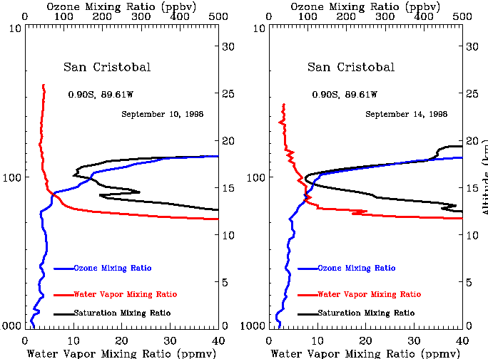
Figure 9 shows the vertical profiles of water vapor mixing ratio (red) and saturation mixing ratio of water vapor (black) calculated from observed temperature together with the ozone mixing ratio (blue) for September 10 (left) and 14 (right).
It is readily seen that the tropopause region is not saturated in September 10 while it is almost saturated in September 14 at San Cristóbal. This is an evidence that the tropopause region in the eastern Pacific in Northern summer could become saturated during the passage of Kelvin waves even though the region is relatively warm as compared to the western Pacific in Northern winter. By keeping the structure of Kelvin waves (e.g., Figure 8 of Fujiwara et al., 1998) in mind, we can see from Figure 8 that September 10 is the day when the downward displacement of the air mass is located just below the tropopause, while the displacement reaches almost highest in September 14. Since such displacement could safely be regarded as adiabatic, we could expect that the tropopause region is relatively warm due to adiabatic compression in September 10, while it is cold in September 14. Thus the saturation condition of the tropopause region is controlled by the phase of Kelvin waves. As the upward (downward) displacement associated with these waves corresponds to the cold (warm) tropopause, the air mass must be cold and dry when it enters the stratosphere and the downward motion is expected when the tropopause region is not saturated. This could be another important mechanism that keeps the stratosphere dry. It is therefore very important to estimate the role of these waves in understanding the dryness of the stratosphere.
4. Summary
The annual cycle of total ozone is driven by that of the tropospheric and lower-stratospheric ozone taking maxima in Northern summer and minima in Northern winter almost simultaneously in the whole altitude range. The Tropopause effect is not a major factor that drives such variations, although some contribution is confirmed. The interannual variations of temperature and height of the cold point tropopause is not directly related to the ENSO phenomenon, and the east-west contrast in these quantities are not evident between San Cristóbal and Singapore. Extremely low values of the upper tropospheric ozone have not been encountered even under the El Niño condition in rainy season. The out-of-phase relationship between the ozone and relative humidity is frequently observed in September indicating the long range transport of ozone and its precursors from the continental region. In some cases, low values of ozone concentration is observed in the marine boundary layer whose trajectories are constrained over the west coast of South America. The activity of vertically propagating waves is high in the eastern tropical Pacific, and such waves may play an important role in the water vapor transport between the troposphere and stratosphere thus acting as a "stratospheric draining pump" that maintains the dry condition of the stratosphere.
Acknowledgments
SOWER/Pacific campaigns are conducted by the financial support
from Sumitomo Foundation, Monbusho International Scientific Research
Program, and Asahi Breweries Foundation. The observations at San
Cristóbal are made possible by the collaboration with the Instituto
Nacionál de Meteorología e Hidrología (INAMHI), Ecuador.
References
Fujiwara, M., K. Kita, and T. Ogawa, 1998: Stratosphere-troposphere exchange of ozone associated with the equatorial Kelvin wave as observed with ozonesondes and rawinsondes. J. Geophys. Res., 103, 19173-19182, 1998.
Fujiwara, M., and M. Takahashi, 2000: The role of equatorial waves in stratosphere-troposphere exchange, Atmospheric Ozone, Proceedings of the Quadrennial Ozone Symposium -Sapporo 2000-, 391-392.
Hasebe, F., M. Shiotani, T. Ogawa, S. Oltmans, K. Gage, H. Vömel, 1998: SOWER/Pacific is to be started on a campaign basis. SPARC Newsletter, 10, 32.
Hasebe, F., H. Vömel, M. Shiotani, N. Nishi, S. Oltmans, T. Ogawa, and K. Gage, 1999: First results from SOWER/Pacific. SPARC Newsletter, 12, 22-23.
Hasebe, F., M. Shiotani, H. Vömel, M. Fujiwara, N. Nishi, M. Niwano, T. Uetake, M. Ikeda, T. Ogawa, S. Oltmans, and K. Gage, 2000: First results from the SOWER/Pacific 1998/1999 campaigns. Atmospheric Ozone, Proceedings of the Quadrennial Ozone Symposium -Sapporo 2000-.
Hasebe, F., and H. Koyata, 2001: Dynamical properties of the tropical atmosphere derived from rawin sonde observations at Singapore and San Cristóbal. in preparation.
Oltmans, S. J., B. J. Johnston, J. M. Harris, H. Vömel, K. Koshy, P. Simon, R. Bendura, A. M. Thompson, F. Hasebe, and M. Shiotani, 2000: Evidence for the influence of biomass burning on tropospheric ozone in both the eastern and western tropical Pacific. Atmospheric Ozone, Proceedings of the Quadrennial Ozone Symposium -Sapporo 2000-, 29-30.
Shiotani, M., 1992: Annual, quasi-biennial, and El Niño-Southern Oscillation (ENSO) time-scale variations in equatorial total ozone. J. Geophys. Res., 97, 7625-7633.
Shiotani, M., and F. Hasebe, 1994: Stratospheric ozone variations in the equatorial region as seen in stratospheric aerosol and gas experiment data. J. Geophys. Res., 99, 14575-14584.
Shiotani, M., M. Fujiwara, S. Xie, H. Hashizume, T. Saito, T. Watanabe, and F. Hasebe, 2000: SOWER/Pacific the Shoyo-maru Pacific Ocean-Atmosphere Survey. SPARC Newsletter, 14, 17-18.
Shiotani, M., M. Fujiwara, H. Hashizume, F. Hasebe, S-P. Xie, T. Watanabe, and Shoyo-maru Mission Team, 2000: SOWER/Pacific - the Shoyo-maru cruise in the equatorial eastern Pacific. Atmospheric Ozone, Proceedings of the Quadrennial Ozone Symposium -Sapporo 2000-, 19-20.
SOWER Project, 1998: SOWER Proposal, Workshop Report, 97POA1-D007, Earth Science and Technology Organization, Tokyo, 105-6791, Japan, 61 pp.
Tsuda, T., Y. Murayama, H. Wiryosumarto, S. Woro, B. Harijono, and S. Kato, 1994: Radiosonde observations of equatorial atmosphere dynamics over Indonesia, 1. Equatorial waves and diurnal tides. J. Geophys. Res., 99, 10491-10505.
Vömel, H., S. J. Oltmans, D. Kley, and P. J. Crutzen, 1995: New evidence for the stratospheric dehydration mechanism in the equatorial Pacific, Geophys. Res. Lett., 22, 3235-3238.
Vömel, H., F. Hasebe, M. Shiotani, S. Oltmans, N. Nishi, T. Ogawa, and M. Niwano, 2000: Water vapor and ozone observations during SOWER/Pacific, 1998 and 1999. Atmospheric Ozone, Proceedings of the Quadrennial Ozone Symposium -Sapporo 2000-, 165-166.
Back to
| Session 1 : Stratospheric Processes and their Role in Climate | Session 2 : Stratospheric Indicators of Climate Change |
| Session 3 : Modelling and Diagnosis of Stratospheric Effects on Climate | Session 4 : UV Observations and Modelling |
| AuthorData | |
| Home Page | |