 |
Stratospheric Processes And their Role in Climate
|
||||||||
| Home | Initiatives | Organisation | Publications | Meetings | Acronyms and Abbreviations | Useful Links |
![]()
|
Stratospheric Processes And their Role in Climate
|
||||||||
| Home | Initiatives | Organisation | Publications | Meetings | Acronyms and Abbreviations | Useful Links |
![]()
Report of the 2nd International SOWER Meeting
San Cristóbal, Galápagos, Ecuador, 10-15 July 2004
Fumio Hasebe, Hokkaido University, Sapporo, Japan (f-hasebe@ees.hokudai.ac.jp)
M. Shiotani, M. Fujiwara, T.J. Dunkerton, I. Folkins, P. Fortuin, A. Gettelman, N.O. Hashiguchi, S. Iwasaki, Y. Kasai, N. Nishi, M. Niwano, S. Oltmans,
L. Poveda, W, Randel, K. Rosenlof, Y. Tsushima, H. Vömel, and K. Yamazaki
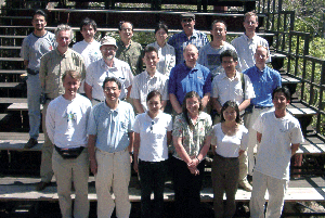 |
Participants of the SOWER meeting (from left to right) First row:I. Folkins, M. Shiotani, Y. Kasai, K. Rosenlof, Y. Tsushima, S. Iwasaki. Second row:P. Fortuin, T. Dunkerton, M. Niwano, S. Oltmans, M. Fujiwara, A. Gettelman. Third row:L. Poveda, F. Hasebe, K. Yamazaki, N. O. Hashiguchi, C. Teran, N. Nishi, H. Vömel For better resolution, please contact the SPARC Office |
Introduction
The Soundings of Ozone and Water in the Equatorial Region (SOWER) was initiated in the late 1990's (Hasebe et al., 1998) for the purpose of improving our understanding of the distribution and variabilities of ozone and water vapour in the tropics. A series of ozone and water vapour sonde launches has been conducted, together with conventional radiosonde observations at several tropical stations such as San Cristóbal, Galápagos (eastern Pacific), Christmas Island, Kiribati (central Pacific), and Watukosek, Indonesia (western Pacific). These data constitute a unique dataset for the monitoring of water vapour in the tropical stratosphere and provide key information pertaining to transport processes between the troposphere and the stratosphere.
The identification of the tropical tropopause region has changed drastically since the introduction of the Tropical Tropopause Layer (TTL), leading to several new hypotheses on the dehydration of the stratosphere. Existing satellite data enables the study of long-term trends in water vapour, and with the launch of EOS/AURA in July 2004, high quality constituent data are becoming available. A large observational campaign in the equatorial region has been proposed by the United States to support the satellite programme, and the SOWER Team is also preparing an intensive campaign in the western tropical Pacific in the coming northern winter. In view of these programmes, we believe it is quite timely to have a focused scientific discussion on the dehydration process in the TTL, following the first of such meetings in October 1997 (SOWER, 1998).
The scientific sessions were divided into the following subjects: (i) Development of observational techniques; (ii) Observational descriptions of UT/LS water vapour; (iii) Atmospheric processes influencing stratospheric water vapour; (iv) The role of UT/LS water vapour in climate; (v) Hypotheses on the dehydration mechanism in the TTL; (vi) Observations of dehydration processes; and (vii) Modelling of stratospheric water vapour and dehydration processes.
In addition to the scientific discussions, ozone and water vapour sonde launches were demonstrated during the meeting for those not familiar with radiosonde procedures. Other highlights of the meeting were the presentation of NASA awards to M. Agama, J. Cornejo and F. Paredes in recognition of their contribution to the Southern Hemisphere Additional Ozonesondes (SHADOZ) programme, and a special talk on the meteorological observation network in Ecuador was given by L. Poveda. A special presentation in memory of James R. Holton was given by A. Gettelman and K. Rosenlof. For details of the meeting see http://sower.ees.hokudai.ac.jp/.
Development of Observational Technique
H. Vömel reviewed the accuracy and performance requirements for frost point hygrometers, noting the limitations of measurements of stratospheric and upper tropospheric water vapour. In cooperation with CIRES at the University of Colorado (CU), a new Cryogenic Frostpoint Hygrometer (CFH) was developed. It is based on the NOAA frostpoint hygrometer, but overcomes its limitations and at the same time reduces power consumption and weight, translating to a corresponding saving in weight and balloon size. Therefore, it is easier to use and to obtain high quality data.
CU-CFH sondes are regularly launched at San Cristóbal (Ecuador), Hilo, HI (USA), and Boulder, CO (USA). CFH sondes were also used during the LAPBIAT Upper Troposphere Lower Stratosphere (LAUTLOS) experiment in Sondankylä, (Finland), and during the SOWER Bandung (Indoniesia) campaign. This instrument was used as the reference sonde during the AIRS Water Vapour Experiment (AWEX) at the ARM/CART site near Lamont, OK (USA) to evaluate the performance of the radiosonde sensors, as well as the Snow White Hygrometer. Comparisons show very good agreement between these sensors.
M. Fujiwara reviewed the performance of the Meteolabor Snow White Hygrometer, which is a low-cost, chilled-mirror hygrometer for radiosonde applications provided by Meteolabor AG, a Swiss company. SOWER began testing this sensor for possible tropical tropopause water vapour measurements in 2000, and has since collaborated with Meteolabor to improve it. Snow White was found to be an appropriate reference sensor for radiosonde humidity sensors in the troposphere (Fujiwara et al., 2003a, Wang et al., 2003); however, the limited cooling strength of the device provides a lower detection limit of 6 to 8% relative humidity (Vömel et al., 2003). The optimization and sensitivity of the controller circuit may also need to be improved for measurements above the tropopause.
Observational Descriptions of UT/LS Water Vapour
S. J. Oltmans and H. Vömel presented a re-evaluation of the long-term water vapour record at Boulder. This 25-year record has shown an increase in water vapour from the tropopause up to an altitude of ~28 km; however, a recent comparison between the Boulder profiles obtained with a balloon-borne hygrometer and HALOE has shown discrepancies since 1997 (Randel et al., 2004).
Removal of contaminated profiles, and a small correction to the instrument calibration after 1990, produced a time series that is in better agreement with the HALOE record after 1997 (Figure 1). The increase over the 25-year period in the 18-22 km layer is 0.75 ± 0.2 %/year, with lesser increases in this layer since 2000, making the change since 1991 small in both the balloon record and the HALOE measurements.
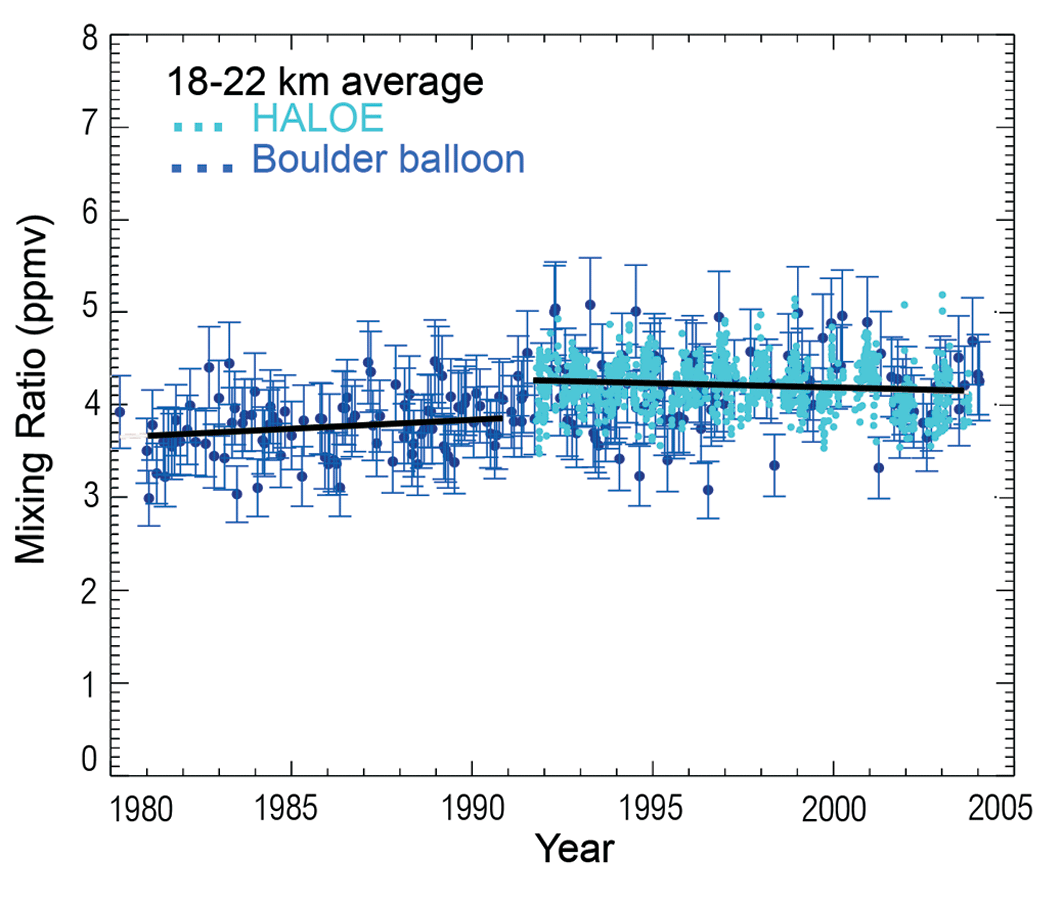 |
Figure 1. Time series of the water vapour mixing ratio in the 18-22 km layer over Boulder, Colorado (USA) from the balloon profile measurements and HALOE satellite observations. For better resolution, please contact the SPARC Office
|
A. Gettelman, on behalf of W. Randel, presented changes in stratospheric water observed in HALOE data which shows an interannual tape recorder of anomalies that propagate vertically and latitudinally in the stratosphere. Since 2001, stratospheric water vapour has been persistently low (by ~0.5 ppv; Figure 2). These low values spread from the tropics, and are also seen in POAM data which is correlated with HALOE observations. The changes in HALOE H2O are also correlated with tropopause temperature anomalies throughout the record. The most recent values of water vapour (to April 2004) are still low, as are tropopause temperatures. These temperature anomalies are centred in a narrow layer just above the tropical tropopause.
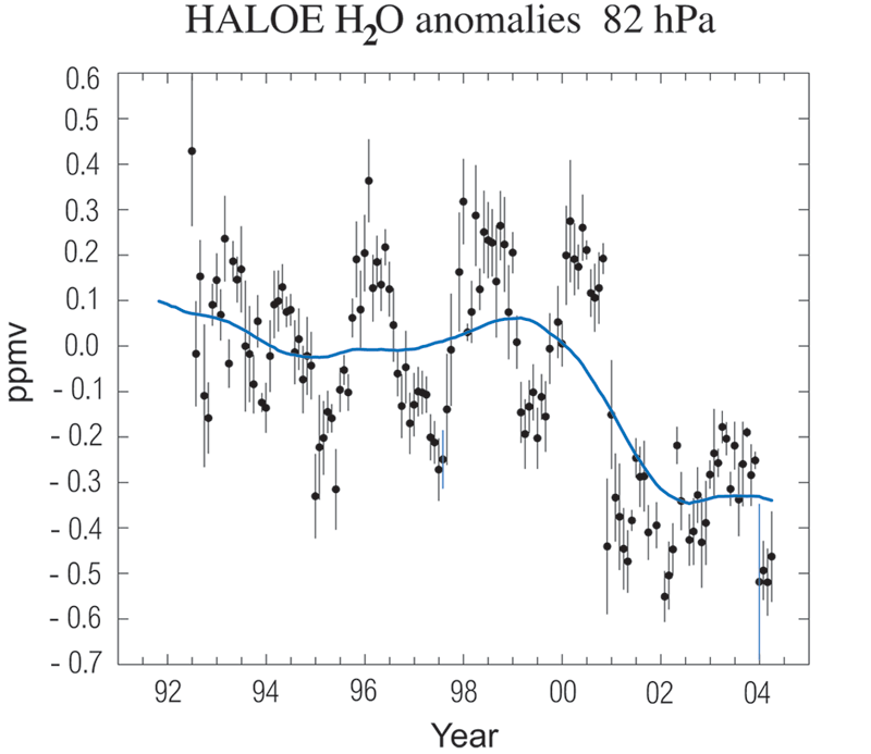 |
Figure 2. Time series of near-global (60°N-60°S) anomalies in lower strato-spheric (82 hPa) water vapour derived from HALOE satellite measurements. The data have been de-seasonalized; the circles show monthly mean values, and the error bars denote the monthly standard deviation. The solid line is a Gaussian-weighted running mean (using a Gaussian half-width of 12 months). [This is an update from Randel et al., 2001].
For better resolution, please contact the SPARC Office |
Tropical ozonesondes also show low ozone from 16-18 km after 2001, with the largest changes centred around, or just below the tropical tropopause. Ozonesonde anomalies are similar to satellite (SAGE II) ozone anomalies over this period, and SAGE II ozone data show that the anomalies are centred in the tropics.
Temperature and ozone changes are consistent with an increase in tropical upwelling (the Brewer-Dobson circulation), however there is not conclusive evidence of increases in extratropical planetary wave forcing. Other mechanisms which can explain the recent changes include persistent changes in tropical convection or ozone decreases leading to cooling.
K. Rosenlof examined the observed drop in water vapour at the end of 2000 seen in both the CMDL and HALOE records at midlatitudes. This drop is also seen in the HALOE and SAGE II data sets in the tropics, and, albeit delayed by a few months, in the POAM satellite Northern Hemisphere (NH) water vapour data at high latitudes. The timing of this drop corresponds to a significant drop in NCEP tropopause temperatures, and a drop in the cold point temperature as measured by operational radiosondes, in-dicating a possible change in vertical stability in the upper tropical troposphere.
The reasons for the dramatic drop in temperatures are not known, but it is likely that enhanced uplift near the tropopause is responsible. If this continues, it will likely result in a decrease in stratospheric water at upper levels over the next few years, especially since a corresponding increase in surface methane is not occurring at this time.
A. Gettelman gave a historical overview of satellite observations of water vapour in the TTL, starting with LIMS in the stratosphere, and HALOE and MLS in the TTL (Kley et. al., 2000). Satellites such as HALOE and SAGE have helped reveal that there are significant instances of subvisible cirrus clouds in the tropics (Wang et al., 1996), which may account for a significant amount of dehydration in the TTL. In addition, the ATMOS instrument on the space shuttle measures water vapour and water vapour isotopes from space.
New instrumentation promises a more detailed picture of TTL water vapour from space. Many of these sensors are on a series of NASA satellites called the "A-Train", which will observe the same location on the Earth at the same time. Aura contains both HIRDLS and MLS limb sounding instruments measuring TTL water vapour. On the Aqua satellite, tropospheric water vapour (up to 200 hPa) is measured by the Atmospheric InfraRed Sounding (AIRS) suite, and TTL cloud properties are determined by the Moderate-Resolution Imaging Spec-trometer (MODIS) radiometer with high spatial and moderate spectral resolution.
The future challenges will be to integrate the data from these various instruments, together with cloud data and data from other instruments, to estimate long term variability in the TTL.
H. Vömel presented results from water vapour and ozone soundings taken at San Cristóbal and other tropical sites. These results have revealed a wide variety of processes that control the water vapour content in the TTL. Convective processes can dry air rising within cumulonimbus clouds to well below the mean stratospheric water vapour mixing ratio. The outflow of these convective events has been observed both in the Western Pacific region as well as over San Cristóbal. This process is highly seasonal for any given geographic location. At San Cristóbal this process also shows a clear dependency on the El Niño phase. Non-convective drying through cirrus clouds, which form at a cold tropopause, has been observed frequently at San Cristóbal during the austral winter and spring months.
During the Austral summer and early fall, when the tropical tropopause is typically much warmer, little dehydration has been observed over San Cristóbal. In one case, some indication of dehydration in the upward phase of a Kelvin wave event was observed, which may constitute an important dehydration mechanism during the warm season. The geographic pattern of the tropopause temperatures also reflects the importance of these regions for dehydration. At Juazeiro do Norte (Brazil) for example, no dehydration was observed during the season of cold tropopause temperatures, since in this region, the mean tropopause temperature is generally too warm to contribute to the dehydration in the TTL.
The tropopause temperatures over San Cristóbal showed a clear cooling in 2000, and cold temperatures continue in 2004. Therefore, it is to be expected that the geographic region of the eastern Pacific continues to play a role in dehydration, even though it is generally located outside the region of coldest tropopause temperatures.
K. Rosenlof presented results from the January 2004 Pre-AVE WB57-F Aircraft Experiment based in San Jose (Costa Rica). These flights were part of a test mission to ready an instrument suite and demonstrate capabilities for validation of the Aura satellite, launched in July 2004. One of these flights was designed to be a comparison with the CMDL frost point balloon launched from San Cristóbal. Significant differences are seen between the aircraft and balloon measurements, with the aircraft measurements approximately 1 ppmv higher at the altitude of the water vapour minimum. The net result of the large differences between the aircraft and balloon measurements translates into large differences in estimated saturations with respect to ice. In particular, the aircraft data show large supersaturations with respect to ice that are not evident in the frost point data. Statistics on numbers of points showing high supersaturations with respect to ice differ between the CMDL and aircraft data sets, with the aircraft data showing a higher frequency of supersaturation with respect to ice than the frost point balloon.
The differences noted in the comparison are consistent with those reported in the SPARC water vapour assessment (Kley et al., 2000). These differences are of concern, because uncertainties in the water vapour measurements as based on comparisons between techniques/platforms are large enough to preclude making conclusions as to what processes control the stratospheric entry value of water vapour. The reasons for the differences noted are not yet known. Determining why large differences exist between these WB-57F aircraft instruments and the balloon frost point instrument at low water vapour values is a significant problem that requires close examination. Before using either set of data for satellite validation, these differences should be understood.
T. J. Dunkerton presented evidence for a "trimodal" distribution of extreme values of ozone and water vapour concentration in NH summer, using HALOE data from 1991-2004. Low values of ozone and water vapour concentration are found near the equator in the western tropical Pacific (as in NH winter), but over the major monsoon regions of North America and South Asia there exist high concentrations of water vapour, presumably due to moistening by deep convection, while ozone is low over Asia but high over North America. Evidently the Asian monsoon circulation is stronger and somewhat deeper than the monsoon circulation over North America, causing air within the Tibetan anticyclone to be relatively isolated and depleted in ozone, due to transport of ozone-poor air from the troposphere.
Since September 1999, weekly ozone- and radiosondes have been launched at Paramaribo station (Suriname) (5.8°N, 55.2°W), on the northern coast of South America. Since October 2002, more accurate water vapour balloon observations have been made with the Snow White hygrometer, installed at a receiving station through a collaboration between KNMI, Kyoto University and Hokkaido University (Japan). P. Fortuin, G. Verver, P. Dolmans, M. Fujiwara and H. Kelder presented an analysis of the water vapour observations from 16 of these launches over the period October 2002-June 2003 (11 launches) and March-April 2004 (5 launches).
Observations suggest a steady ascent of moisture-rich air through the TTL above Surinam, although additional evidence is needed since the humicaps observations at these high altitudes are unreliable. The coinciding recurrence of inertial instability in the UT during the South American Monsoon is also analyzed, as well as the possible role this might play in the redistribution of water vapour. This is done on the basis of a case study with ECMWF analyses and shows a stacked vertical cellular flow (Fortuin et al. 2003) confirming the theory of symmetrical inertial instability.
N.O. Hashiguchi presented an investigation of seasonal and interannual variations of the cold point tropopause (CPT) temperature, based on operational rawinsonde data over Indonesia and the surrounding region (90°-140°E, 15°N-15°S) from 1992 to 1999. The cold point temperature has an annual variation with a maximum/minimum in northern summer/winter, which is the same as that observed at other tropical stations, and the peak-to-peak difference is about 6 K at all the stations. In latitudinal distribution, the cold point temperature is the warmest over the equator and decreases with respect to latitude for both JJA and DJF. This is because the analysis region is located in the upper tropospheric warm anomaly region, on the west side of the Matsuno-Gill response, and the latitudinal structure in the section is opposite to a zonal mean structure presented by Seidel et al. (2001). The CPT temperature is also the warmest over 100°E and decreases to the east with respect to longitude.
During the non-ENSO period from July 1992 to April 1997, the CPT temperature was decreasing over the entire analysis region without changing the longitudinal inclination. In this period, activation of convective clouds in OLR and strengthening of the upper tropospheric wind of local Hadley circulations were also seen. It seems that these tropo-spheric changes lead to cold CPT temperatures through adiabatic cooling in this period.
Atmospheric Processes Influencing Stratospheric Water Vapour
N. Eguchi and M. Shiotani presented results from MLS and CLAES data, which suggest a direct effect of convective activity on wet anomalies up to a height of 146 hPa, but an indirect effect by the dynamical response to the convective heating at 100 hPa. Dynamical structures around the tropopause level are characterized by equatorial temperature anomalies (Kelvin wave response) and by subtropical anticyclonic gyres (Rossby wave response). Between the two gyres, the easterly wind blowing through the equatorial cold region may cause dehydration, along with the formation of cirrus clouds. As the northern gyre intensifies, tropical dry air is transported to the subtropical Pacific and eventually to the equatorial Pacific. It is suggested that the temperature and flow variations due to the coupled Kelvin-Rossby wave structure play an important role in dehydrating air in the tropical and subtropical tropopause region.
M. Fujiwara presented a case study of an Upper Tropospheric Inversion (UTI) and jet in the tropics. Ship-board radiosonde measurements revealed a persistent temperature inversion layer at 12-13 km over the tropical eastern Pacific, which was located at the top of a very wet layer originating from the ITCZ to the north (Fujiwara et al., 2003b). Radiative transfer calculations suggested that this UTI was produced and maintained by strong longwave cooling in the wet layer.
A strong easterly jet stream was also observed at 12-13 km, and was in thermal wind balance with the meridional temperature gradients produced by the cloud by radiative processes in the ITCZ and the wet outflow. The jet in turn acted to spread inversions further downstream through the transport of radiatively active water vapour. This feedback mechanism may explain the omnipresence of temperature inversions and layering structures in trace gases in the tropical troposphere. Examination of high-resolution radiosonde data at other sites in the tropics indicates that similar UTIs often appear around 12-15 km. The UTI around 12-15 km may thus be characterized as one of the "climatological" inversions in the tropical troposphere, forming the lower boundary of the TTL.
N. Nishi, M. Yamamoto, A. Hamada, J. Hashiguchi and S. Fukao presented the vertical wind distribution in and around upper tropospheric cirriform clouds, obtained by using the VHF radar Equatorial Atmospheric Radar (EAR) wind data at Sumatra Island (Indonesia) (0°N, 100°E), and GOES IR data in November 2003. It was found that the most dominant variability in the middle and upper troposphere is a high frequency oscillation with vertically standing phase structure, with a period slightly longer than the Brunt Väisällä frequency. The amplitude is sometimes more than 30 cm/s. However, in some cases during late November, strong upward motion was detected not only in the lower half of the domain, but up to 15 km for clusters with the same cloud top as early November. Large scale conditions such as wind shear, stability and humidity may effectively control the vertical wind distribution in the tropical cirriform clouds in large scale cloud clusters.
Y. Kasai, J. Urban, M. Lautié, D. Murtagh, P. Ricaud, and the Odin/SMR group presented results of the water vapour isotopes observed by the Sub-Millimetre Radiometer (SMR) onboard the Odin satellite, which is a satellite funded jointly by Sweden, Canada, Finland and France, and was launched in February 2001. In aeronomy mode, the SMR dedicates various target bands to observations of trace constituents relevant to stratospheric/mesospheric chemistry and dynamics, such as O3, ClO, N2O, HNO3, H2O, CO, as well as isotopes of H2O and O3.
The global distribution of water vapour isotopes and its seasonal variation were obtained for the first time by Odin/SMR measurements. The dD value of water vapour in the stratosphere agrees with the past measurements and a model (Ridal and Siskind, 2002). It increases with altitude from the TTL to the stratosphere. The methane contribution to the increase of dD was discussed and the dD value overhead of the TTL was estimated.
Role of UT/LS Water Vapour in Climate
A dominant component of climate sensitivity is the size of the water vapour feedback; the change in water vapour concentrations in response to increased greenhouse gases, and the associated radiative impact. However, understanding the water vapour feedback in the tropical troposphere is limited by our understanding of what processes drive changes in tropical water vapour concentrations. Sources and sinks of water vapour are complex; the tropical troposphere is moistened by detrainment of near saturated air and by evaporation from falling precipitation. Water vapour concentrations are reduced, locally, mainly by downward advection of drier air from higher levels. A further complication is that the budgets of mass and water vapour are strongly coupled in the tropics, since most upward motion arises from condensation, while downward motion arises from radiative and evaporative cooling.
Coupling of the mass and water vapour budgets can be used to put constraints on the sources and sinks of water vapour. For example, in the mid-troposphere (5-10 km), it can be shown that the major source of water vapour is evaporation of falling ice. This evaporation also drives a downward descent that must be offset by vertical motions occurring within clouds and by clear sky subsidence. I. Folkins showed that, in a tropical mean model, the enforcement of vertical mass flux balance gives rise to a constraint on the tropical mean relative humidity profile in this height interval which is well obeyed in the current atmosphere.
Y. Tsushima presented changes in UT/LS water vapour and clouds modelled by the CCSR/NIES GCM 5.7b under global warming scenarios, with different climate sensitivities and different treatment of the temperature dependency of the phase of cloud and fall speed of melted cloud ice. The temperature changes in 2 x CO2 experiments ranged from 4.0 K in the low sensitivity model to 6.4 K in the high sensitivity model. In the control climate, both versions showed much higher concentrations of water vapour and clouds in the upper troposphere than expected from observations. In the low sensitivity model, the fraction of high thin cloud is larger and high thick cloud is smaller than in the high sensitivity model.
The equilibrium states of the control run and the 2 x CO2 run show decreases in the upper tropospheric water vapour in both models, leading to a significant decrease in high cloud, although this change is much more significant in the high sensitivity model. The role of high clouds in the radiation budget of the earth-atmosphere system depends on optical depth; high thin cloud acts to warm the atmosphere, while high thick cloud cools. Thus, the decrease in high clouds can reduce both the warming and cooling effect to the system. In these particular experiments, the reduction of cooling seems to dominate and strengthen the magnitude of the warming, with a more significant response in the high sensitivity model. For further discussion, evaluation of the distribution of cloud and water vapour in the upper troposphere in the current climate, using the observational data, is necessary.
Hypotheses on the Dehydration Mechanism in TTL
A. Gettelman and C. Webster highlighted some recent work using water vapour isotopes to understand dehydration in the TTL. The process of fractionation of heavier isotopes of water (HDO), due to their lower vapour pressures and preferential partitioning into condensed phases, is temperature dependent. Lifting a parcel from the surface and removing the condensed phase water (a so-called Rayleigh curve) results in a loss of up to 95% of HDO relative to the surface abundance, however observations indicate the stratosphere is only about 65% depleted in HDO. Recent observations indicate significant variability in the TTL below the tropopause, with values in total water (including ice) of no depletion (0%) to 95% depletion (Webster and Heymsfield, 2003).
An analytical microphysical model was described which calculates water vapour and condensate along a trajectory, accounting for condensation, evaporation and sedimentation of ice, and fractionation of water isotopes. The model is able to reproduce observations of HDO in the TTL, with a similar range of variability. Depletion due to individual convective events, and in situ cirrus formation are well captured. Isotopic observations and the model are consistent with (1) convective transport and mixing up to the level of main convective outflow, (2) mixing of air with ice detrained from convection (the evaporation of convective anvils) and (3) slow ascent under supersaturated conditions into the stratosphere, with the final dehydration occurring in cirrus clouds. Climatological experiments with the same model and ensembles of back trajectories indicate that more depletion is expected around regions of deep convection, such as the Western Pacific.
Observations of Dehydration Processes
Vertical profiles of ozone and water vapour obtained by radiosondes at stations in the tropical Pacific have shed light on the role of vertically propagating atmospheric waves in the dehydration processes taking place in the TTL (Hasebe et al., 2001, Fujiwara et al., 2001). On the other hand, the idea emphasizing the role of horizontal advection as a key process in determining the water vapour concentration in the stratosphere (Holton and Gettelman, 2001) is becoming widely accepted (Randel et al., 2001, Hatsushika and Yamazaki, 2003, Eguchi and Shiotani, 2004).
To enable us to identify the mechanism determining the long-term trend of stratospheric water vapour, it is necessary to quantify the contribution of each process. The Lagrangian description from the modification of the air quality is made possible by the introduction of the "match" method. This method has prov-en effective in describing the ozone loss in the polar vortex (Rex et al., 1998), and many questions can be answered by applying it to the dehydration in the TTL.
F. Hasebe and the SOWER Team presented calculations of air trajectories in the TTL in northern winter, which show dependence on the phase of the El Niño as shown in Figure 3 (p. IV), which illustrates those of possible "match" pairs being caught by existing stations for the cases of December 1998 (non-El Niño) and 1997 (El Niño). The first trial of water vapour "match" is being planned for the northern winters of 2004-2005 and 2005-2006, with the aid of these analyses. Preliminary analysis of data taken during the December 2003 campaign at Bandung and Tarawa (Kiribati) indicates some dependence of water vapour concentration of the air parcels on their temperature history during horizontal advection.
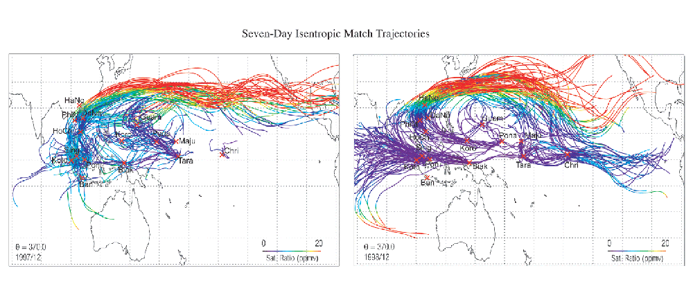 |
Figure 3. 370 K isentropic trajectories for December 1997 (left) and December 1998 (right) that are considered as "match" between the stations shown on the map. Calculations are based on ECMWF operational analyses and illustrations are color coded by saturation mixing ratio of the air parcel along the trajectories. For better resolution, please contact the SPARC Office |
M. Niwano presented a study examining the global occurrence of cirrus clouds and dehydration in the TTL in terms of short term variation, based on upper tropospheric data from HALOE and Singapore rawinsondes.
HALOE data for the period of January 1993 exhibits the global occurrence of tenuous cloud (TC) and its sedimentation, which is synchronized with downward- and eastward-propagating cold anomalies of the equatorial Kelvin wave coupled to the Madden-Julian Oscillation (MJO) convection. To the east of the MJO, TCs occur up to the 100 hPa level through adiabatic cooling due to large scale upward motion of the MJO-coupled Kelvin wave. To the west of the MJO, TCs are spread by downward and westward motions of the MJO-coupled Kelvin wave, and disappear due to sedimentation and evaporation. Apart from the MJO convection, a layered TC appears over Singapore with a thickness of ~2 km and a fall speed of about 10 mm, which can be accounted for by sedimentation of cloud particles with a radius of 10 mm. On a global scale, the occurrence, transport, and sedimentation of TCs are controlled by the MJO-coupled equatorial Kelvin wave, which is inseparable from spreading from anvil and large-scale upwelling.
S. Iwasaki presented observations of subvisual cirrus clouds (SVC) using a 1064 nm lidar, a 95 GHz cloud radar and radiosondes launched every 3 hours, at 2°N, 138°E for a period of one month (Iwasaki et al., 2004). The observed sedimentation rate of SVCs was 3 cm/s, the same as the theoretical terminal velocity of ice crystals, and the average effective radius was estimated to be 10 mm. The result shows that sedimentation is important for dissipation of SVC. Moreover, the SVCs did not appear to correspond to negative temperature anomalies as expected, but rather they dissipated corresponding to positive temperature anomalies, DT>1.5°C, suggesting that the relative humidity is important to their formation as discussed by Jensen et al. (2001).
Modelling of Stratospheric Water Vapour and Dehydration Processes
H. Hatsushika and K. Yamazaki presented a modelling study of the stratospheric drain over Indonesia and dehydration within the TTL using air parcel trajectories to diagnose results from an atmospheric general circulation model (AGCM). The AGCM has strong upward motions in the lower part of the TTL over the maritime continent and the western tropical Pacific, corresponding to the stratospheric fountain region, and downward motions in the upper part of the TTL over Indonesia, representing the stratospheric drain. In the TTL, strong easterlies prevail, and the cold ascent region tilts eastward. Upward motion over areas of deep convection is suppressed by longwave cooling.
Tropospheric air parcels are advected upward to the bottom of the TTL mainly from the stratospheric fountain region. A pair of anticyclonic circulations in the tropical western Pacific entrains air parcels, which then pass through the equatorial cold region during the slow ascent in the TTL. This slow spirally ascending motion brings about low humidity in the stratosphere, despite the local downward motion over Indonesia. In addition, transient disturbances, particularly low-frequency disturbances such as Kelvin waves and the MJO (Mote et al., 2000), produce intermittent upward motions over the fountain region, resulting in effective dehydration of the air. The spiral ascent and transient mechanisms are key factors in the dehydration process in the TTL.
It is also found that air in the tropical lower stratosphere is more dehydrated in La Niña years, than in El Niño years.
Acknowledgements
We are grateful to M. Agama and the members of the Aerological Station at San Cristóbal for their help in organizing such a stimulating meeting, and to El Parque Nacional Galápagos for providing the meeting facility. This meeting was partially supported by the Grant-in-Aid for Scientific Research by JSPS, the Global Environmental Research Fund from the Japanese Ministry of the Environment, Kyoto University Active Geosphere Investigations for the 21st Century COE Programme, and the Dispatch of Researchers Overseas Programme by MEXT of Japan.
References
Eguchi, N., and Shiotani, M., Intraseasonal variations of water vapour and cirrus clouds in the tropical upper troposphere. J. Geophys. Res., 109, D12106, doi:10.1029/2003JD004314, 2004 .
Fortuin, J. P. F., et al., Inertial instability flow in the troposphere over Suriname during the South American monsoon. Geophys. Res. Lett., 30 (9), 1482, doi:10.1029/2002GL016754, 2003.
Fujiwara, M., et al., Water vapour control at the tropopause by equatorial Kelvin waves observed over the Galapagos. Geophys. Res. Lett., 28, 3143 3146, 2001.
Fujiwara, M., et al., Performance of the Meteolabor “Snow White” chilled-mirror hygrometer in the tropical troposphere: Comparisons with the Vaisala RS80 A/H-Humicap sensors. J. Atmos. Oceanic Technol., 20, 1534–1542, 2003a.
Fujiwara, M., et al., Upper-tropospheric inversion and easterly jet in the tropics. J. Geophys. Res., 108, 2796, doi:10.1029/2003JD003928, 2003b.
Hasebe, F., et al., SOWER/Pacific is to be started on a campaign basis. SPARC Newsletter N°10, 32, 1998.
Hasebe, F., et al., Initial results from SOWER/Pacific 1998-2000 campaigns. Proceedings of the 2nd SPARC General Assembly, CD-Rom 1, 2001.
Hatsushika, H., and Yamazaki, K., Stratospheric drain over Indonesia and dehydration within the tropical tropopause layer diagnosed by air parcel trajectories. J. Geophys. Res., 108, doi:10.1029/2002JD002986, 2003.
Holton, J. R., and Gettelman, A., Horizontal transport and the dehydration of the stratosphere. Geophys. Res. Lett., 28, 2799–2802, 2001.
Iwasaki, S., et al., Subvisual cirrus cloud observations using a 1064-nm lidar, a 95 GHz cloud radar, and radiosondes in the warm pool region. Geophys. Res. Lett., 31, L09103, doi:10.1029/2003GL019377, 2004.
Jensen, E. J., et al., A conceptual model of the dehydration of air due to freeze-drying by optically thin, laminar cirrus rising slowly across the tropical tropopause. J. Geophys. Res., 106, 17237–17252, 2001.
Kley, D., et al., SPARC Assessement of Upper Tropospheric and Stratospheric Water Vapour, WCRP 113, WMO/TD-No. 1043, 0, SPARC Report No. 2, 2000.
Mote, P. W., et al., Intraseasonal variations of water vapour in the tropical upper troposphere and tropopause region. J. Geophys. Res., 105 (D13), 17457–17470, 10.1029/2000JD900158, 2000.
Randel, W. J., et al., Seasonal variation of water vapour in the lower stratosphere observed in halogen occultation experiment data. J. Geophys. Res., 106, 14313–14325, 2001.
Randel, W. J., et al., Interannual changes of stratospheric water vapour and correlations with tropical tropopause temperatures. J. Atmos. Sci., 61, 2133–2148, 2004.
Rex, M., et al., In situ measurements of stratospheric ozone depletion rates in the Arctic winter 1991/1992: a Lagrangian approach. J. Geophys. Res., 103, 5843–5854, 1998.
Ridal, M., and Siskind, D. E., A two-dimensional simulation of the isotopic composition of water vapor and methane in the upper atmosphere, J. Geophys. Res., 107 (D24), 2002JD002215, 2002.
Seidel, D., et al., Climatological characteristics of the tropical tropopause as revealed by radiosondes. J. Geophys. Res., 106, 7857–7878, 2001.
SOWER Project Team, SOWER Proposal, Workshop Report, Earth Science and Technology Organization, 97POA1-D007, 61 pp, 1998. http://wwwoa.ees.hokudai.ac.jp/people/f-hasebe/SOWER/Report.pdf
Vömel, H., et al., The behaviour of the “Snow White” chilled-mirror hygrometer in extremely dry conditions. J. Atmos. Oceanic Technol., 20, 1560–1567, 2003.
Wang, P. H., et al., A 6-year climatology of cloud occurrence frequency from Stratospheric Aerosol and Gas Experiment II observations (1985-1990). J. Geophys. Res., 101, 29407–29429, 1996.
Wang, J., et al., Performance of operational radiosonde humidity sensors in direct comparison with a chilled mirror dew-point hygrometer and its climate implication. Geophys. Res. Lett., 30, 1860,10.1029/2003GL016985, 2003.
Webster, C. R., and Heymsfield, A. J. , Water isotope ratios d/h, 18o/16o, 17o/16o in and out of clouds map dehydration pathways. Science, 302, 1742–1745, 2003
![]()