|
Stratospheric Processes And their Role in Climate
|
||||||||
| Home | Initiatives | Organisation | Publications | Meetings | Acronyms and Abbreviations | Useful Links |
![]()
|
Stratospheric Processes And their Role in Climate
|
||||||||
| Home | Initiatives | Organisation | Publications | Meetings | Acronyms and Abbreviations | Useful Links |
![]()
Start of ILAS-II Operation for the Observation of Stratospheric Constituents
Hirokazu Kobayashi, NIES, Ibaraki, Japan (satmng@nies.go.jp)
Takafumi Sugita, NIES, Ibaraki, Japan (tsugita@nies.go.jp)
Yukio Terao, NIES, Ibaraki, Japan (terao.yukio@nies.go.jp)
Introduction
The ILAS-II sensor (Improved Limb Atmospheric Spectrometer- II) aboard the sun synchronous, polar orbiting satellite ADEOS-II (Advanced Earth Observing Satellite-II) launched by the H-IIA rocket system on December 14, 2002 and has started operation. ILAS II is the successor of ILAS (Sasano, SPARC Newsletter, N°10, 1998). Both ILAS and ILAS II sensors are solar occultation instruments developed by the Ministry for the Environment of Japan (MOE), and designed to observe vertical profiles of various trace gas constituents including ozone (O3), nitric acid (HNO3), nitrogen dioxide (NO2), nitrous oxide (N2O), methane (CH4) and water vapour (H2O), profiles of atmospheric temperature and pressure, as well as profiles of aerosols and polar stratospheric clouds (PSCs) (Hayashida, SPARC Newsletter N°19, 2002). The MOE ozone observational programme is expected to clarify the trends of the ozone layer and other stratospheric properties by obtaining long-term stratospheric ozone data from the ILAS and ILAS-II missions. ILAS-II has similar characteristics and design as the former ILAS sensor but with various advanced features. For example, ILAS had two observational channels (one infrared and one visible), whereas ILAS-II has four: two of those are the same as in ILAS-I, whereas the two new channels are a mid-infrared channel for obtaining precise information on aerosol/PSC characteristics, and another channel to retrieve the profile of ClONO2, which is regarded as a reservoir of ClOx. Table 1 shows the spectral coverage of each channel and its planned observation parameters. In order to improve the tangent height resolution, on the focal plane of the fore telescope ILAS-II has a narrower optical slit corresponding to 1 km vertical IFOV (Instantaneous Field of View) compared to that of ILAS whose slit corresponded to 2 km vertical IFOV.
Target parameters Ch. 1 850 - 1,610 cm-1 O3, HNO3, NO2, N2O, CH4, H2O, aerosol Ch. 2 1,754 - 3,333 cm-1 O3, N2O, CH4, H2O, aerosol, CO2 (for pressure measurement) Ch. 3 778 - 782 cm-1 ClONO2 Ch. 4 12,755 - 13,280 cm-1 temperature, pressure, aerosol Due to the orbital parameters of ADEOS-II (now named Midori-II) solar occultation occurs at high-latitudes in both hemispheres, making it possible for ILAS-II to take measurements from 57° to 73°N and from 64° to 90°S and with about 14 observation points in both hemispheres. These parameters are the same as those of ILAS, except that the recurrent period of ILAS-II is 4 days and that of ILAS was 41 days, hence the longitudinal distance in observation points of ILAS-II between the adjacent nominal orbits is about 240 km at 70° latitude, compared to about 23 km in the case of ILAS. Although ILAS instrument operated only between the beginning of November 1996 till the end of June 1997 when the ADEOS satellite suddenly failed, a large amount of measurements has been acquired that enabled NIES to improve the data retrieval algorithms (currently using version 6.00). We are going to continue the ILAS/ILAS-II data distribution program and also maintain the correlative measurement database (CMDB), which contains and manages ILAS/ILAS-II validation experimental data.
Preliminary operation result
The initial checkout (ICO) exclusively for ILAS-II was implemented over four consecutive days from January 20, 2003. Various satellite functions were running according to schedule, and both the output of the spectrometers and the performance of the solar-tracking sensor were confirmed to be functioning satisfactorily. Some of the data measured by ILAS-II during the ICO were processed and analysed at NIES and vertical profiles of ozone and other atmospheric trace species were retrieved; these results were announced at a press release. However, during ICO and a later checkout on 08/02/2003 it was found that the sun-edge sensor (SES) was not performing as expected. Despite various attempts to adjust the relevant sensor parameters, the normal functions of the SES could not be recovered. Starting on February 12, 2003 the early turn-on (ETO) was implemented for a total of four days. Even though ILAS-II had already been confirmed to be fully capable of fulfilling its primary mission to measure the stratospheric chemical species, we still needed to investigate the cause of the SES nonconformance after the ICO period. By using an engineering model (EM) it was clarified that the slit of the FOV, which concurrently serves as a mirror to project light onto the SES, was deformed due to heating by solar radiation, thereby causing partial attenuation of the amount of light conveyed to the SES. To counter this problem, it was decided to incorporate into the operational system some other tangent height determination methods that do not use the SES; it was also decided to start analysing ILAS-II data at the System Total 1 on March 19, 2003, at which point the entire satellite was operational, and to end on March 22, 2003; also the System Total 2 was to begin on April 2, 2003 and the routine operations were to begin in due course. Clarification of the SES behaviour and assessment of its impact on the data will be continuously investigated, and recently we found that the partial data from SES can still be useful for defining the tangent heights.
The ILAS-II data validation
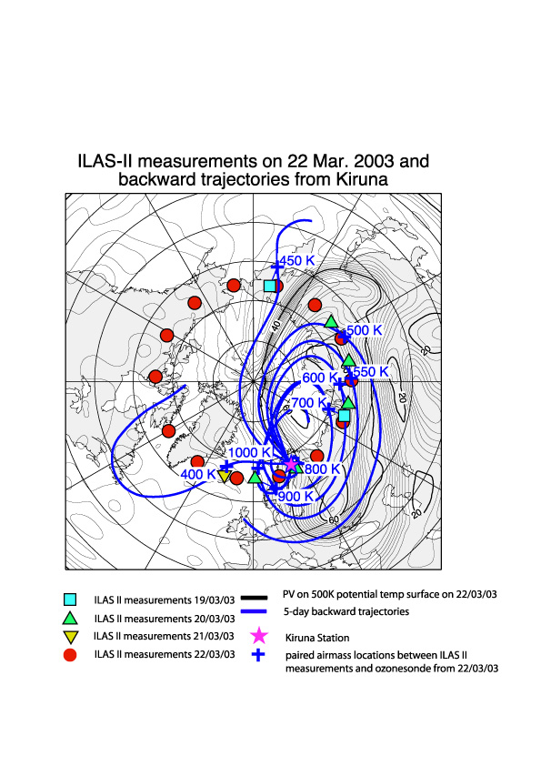
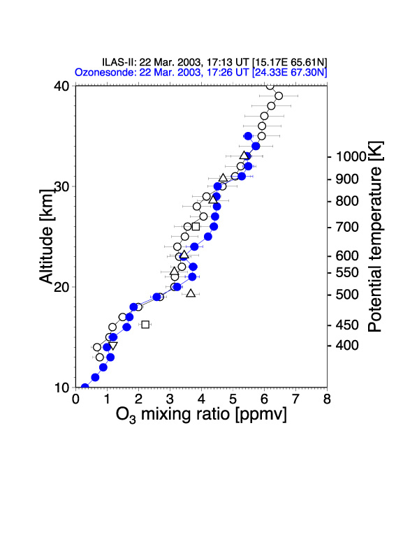
The validation conducted by the ILAS-II project consists of the core experiments, as well as cooperative experiments conducted by various scientists group worldwide. The core experiment plan is composed of the Kiruna balloon campaigns, in cooperation with CNES (France) and with the validation principal investigators, and the ozone/aerosol sonde observations program in Antarctica based on the Syowa station. We plan to validate each target parameter of ILAS-II that is defined as a standard product, and to publish papers on the validation analysis. Unfortunately, the Kiruna campaign planned on April 2003 has been postponed; however, we expect the balloon experiments to be carried out during this winter season. The sensor validation is being conducted by using ozone/aerosol sonde and data from other satellite sensors, such as POAM-III, SAGE-III, and sensors aboard Odin and ENVISAT. Preliminary validation for the ozone profiles was performed using the ozone sondes from the Kiruna and Syowa stations in February and March 2003. A 'Lagrangian' trajectory hunting method has been applied that makes matching data pairs by pursuing the air mass in which ILAS-II and/or sonde observations were carried out. Figure 1 shows an example of these hunted matching data sets, on a potential vorticity map on the 500 K potential temperature surface. For the ILAS-II measurements made between March 19 and 21, 2003, the blue curves indicate the 5-day isentropic backward trajectories for several theta levels, ending over Kiruna where an ozone sounding was performed at 15 UT on March 22, 2003. Figure 2 shows vertical profiles of ozone mixing ratios obtained by ILAS-II and the ozonesonde on March 22, 2003. These two measurements coincided closely with respect to both time and location, allowing a 'traditional' approach of validation analysis. The ozone values hunted by the trajectories using the 'Lagrangian' approach are also shown in Figure 2. The co-located ILAS-II ozone profile and the hunted ILAS-II ozone values on several theta levels were also in good agreement with the ozonesonde profile.
For further details, please visit http://www-ilas2.nies.go.jp/en/
Figure 1. Map of potential vorticity (black contours) on 500 K potential temperature surface on 22 March, 2003. The 14 red circles show the measurement points of ILAS-II on that day. The pink star represents the location of Esrange station, Kiruna (68°N, 21°E), Sweden, where an ozonesonde sounding was made on 22 March, 2003. Blue curves correspond to 5-day backward trajectories for the ozonesonde measurement (the 400, 450, 500, 550, 600, 700, 800, 900, and 1000 K isentropic surfaces shown here). Blue squares, the green triangles, and the reverse yellow triangle correspond to the measurement points of ILAS-II on 19, 20, and 21 March, 2003, respectively, which were then hunted by the backward trajectories. The blue crosses along each trajectory are the location of the air mass paired with the ozonesonde measurements.
Figure 2. Vertical profiles of ozone mixing ratios measured by ILAS-II (black open circles) and ozonesonde (blue open circles) on 22 March, 2003. The ozonesonde profile was averaged using 1 km altitude grid. Several ozone mixing ratios measured by ILAS-II on 19, 20, or 21 March, which were then hunted by the trajectories shown in Figure 1, are also shown as black open squares, a triangle, and a reverse triangle, respectively.
![]()