 |
S P A R C
Stratospheric Processes And their Role in Climate
|
|||||||
| Home | Initiatives | Organisation | Publications | Meetings | Useful Links |
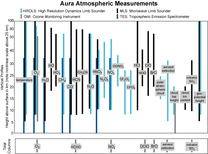
EOS Aura Mission – One Year of Operations M. R. Schoeberl, NASA Goddard Space Flight Center, USA (mark.r.schoeberl@nasa.gov) A. R. Douglass, NASA Goddard Space Flight Center, USA (Anne.R.Douglass@nasa.gov) E. Hilsenrath, NASA Goddard Space Flight Center, USA (hilsenrath@ventus.gsfc.nasa.gov) Introduction Aura (Latin for breeze, formerly EOS CHEM), the last of the large EOS observatories, was launched on July 15, 2004 and has now been operating for over a year. Aura is designed to make comprehensive stratospheric and tropospheric composition measurements from its four instruments, HIRDLS, MLS, OMI and TES. All of the instruments are performing well, although HIRDLS will only deliver data products along one scan position. Aura flies in formation about 15 minutes behind Aqua. The Cloud-Aerosol Lidar and Infrared Pathfinder Satellite Observation (CALIPSO) and Cloudsat, to be launched together, hopefully in late fall 2005, (Stephens et al. 2002) will fly a few minutes behind Aqua. The “A-train” includes this group of satellites, the CNES PARASOL satellite which was launched in December 2004, and the ESSP Orbiting Carbon Observatory (OCO), scheduled for launch in 2008. The measurements from Aura will be within 30 minutes of these other platforms. The A-Train can be thought of as an extended satellite system focusing on climate change. Figure 1 shows the Aura spacecraft and its four instruments (Table 1): the High Resolution Dynamics Limb Sounder (HIRDLS), the Microwave Limb Sounder (MLS), the Ozone Monitoring Instrument (OMI) and the Tropospheric Emission Spectrometer (TES). These instruments were selected because of their complementary measurements, their technological heritage, and the new capabilities they bring to measuring the Earth's atmosphere. Figure 2 graphically shows the vertical range of the various Aura measurements and the instrument that provides them.
Science Objectives of the Aura Mission The objective of the Aura mission is to address three principal science questions:
The strategy Aura will employ in answering these questions is to obtain a comprehensive set of chemical observations at high vertical and horizontal resolution throughout the atmosphere (see Table 1 for details). These measurements, when combined with measurements from field campaigns, other satellite measurements (e.g. Aqua measurements that are made 15 minutes ahead of Aura on roughly the same ground track), and ground-based instrument data, should provide unprecedented insights into the chemical and dynamical processes associated with our atmosphere. Spacecraft and Instrument descriptions The Aura spacecraft is designed for a life of five years with an operational goal of six years. The spacecraft is in an ascending sun-synchronous orbit (98o inclination) at 705 km with an equator-crossing time of 13:45 ±15 minutes. Aura limb instruments were designed to observe roughly along the orbit plane, however, due to an anomaly (discussed below) HIRDLS observations will be off to the side of the Aura ground track. MLS is on the front of the spacecraft (the forward velocity direction) while HIRDLS, TES and OMI are mounted on the nadir side. HIRDLS and TES make limb soundings observing backward while MLS will make limb soundings observing forward. OMI and TES make nadir soundings as shown in Figure 3. The advantage of this instrument configuration is that MLS, OMI and TES would observe the same air mass within minutes.
HIRDLS HIRDLS is a 21 channel infrared limb-scanning filter radiometer designed to make the measurements listed in Table 1 (Gille et al. 2003). HIRDLS can also determine the altitude of polar stratospheric clouds and tropospheric cloud tops. The HIRDLS instrument has a long heritage extending back to Nimbus-6, and was designed to obtain profiles over the entire globe, including the poles, both day and night. Complete Earth coverage (including polar night) could be obtained in 12 hours. HIRDLS was designed to achieve high horizontal resolution using commandable azimuth scans which, in conjunction with a rapid elevation scan, would provide profiles up to 3,000 km apart in an across-track swath. The primary design advantage of HIRDLS over previous infrared limb instruments (LIMS, SAMS, ISAMS, CLAES) was its high vertical and horizontal resolution that extends from the upper troposphere throughout the stratosphere. Current status: After launch, activation of the HIRDLS instrument immediately revealed that something was blocking the optical path so that only a small portion of the aperture could view the Earth’s atmosphere. Studies of the engineering model suggested that a piece of thermal blanketing material ruptured from the back of the instrument during the explosive decompression of launch. This material covers most of the scan mirror. Attempts to remove this material by moving the scan mirror failed. However, even with the 80% blockage, measurements at high vertical resolution can still be made at one scan angle. As of this writing, the HIRDLS principal investigators have demonstrated high vertical resolution retrievals of temperature and ozone and they believe that they can retrieve most of the other constituents as planned. HIRDLS will no longer have its designed horizontal coverage, and with only one side of the aperture available, HIRDLS will not be able to make measurements over the Antarctic. MLS MLS uses microwave emission to measure stratospheric temperature and constituents, and upper tropospheric constituents (Table 1) (Waters et al. 1999,Waters et al. 2006). MLS also has a unique capability to measure upper tropospheric water vapour in the presence of tropical cirrus, and the cirrus ice content. Aura MLS continues the successful effort of UARS MLS (Waters et al. 1993) using advanced technology to provide new measurements. These measurements will be especially valuable for diagnosing the potential for severe loss of Arctic ozone during the critical period when abundances of stratospheric chlorine will still be high, and slight cooling of the stratosphere could exacerbate ozone loss due to chlorine chemistry. MLS is making the first global stratospheric measurements of OH and HO2, constituents that play an important role in stratospheric chemistry. The MLS instrument observes in spectral bands centred near five frequencies: 118 GHz (temperature and pressure); 190 GHz (H2O, HNO3); 240 GHz (O3 and CO); 640 GHz, (N2O, HCl, ClO, HOCl, BrO, HO2, and SO2); and 2.5 THz (primarily for OH). The MLS instrument aboard UARS has demonstrated the MLS capability of measuring upper tropospheric water vapour profiles (Read et al. 1995; Sandor et al. 1998), knowledge of which is essential for understanding climate variability and global warming but which previously has been extremely difficult to observe reliably on a global scale. MLS is unique in its ability to provide these measurements in the presence of tropical cirrus, where important processes affecting climate variability occur. MLS also provides unique measurements of cirrus ice content. The simultaneous MLS measurements of upper tropospheric water vapour, ice content, and temperature, under all conditions and with good vertical resolution, will be of great value for improving our understanding of large scale meteorological systems (such as El Niño) affecting the distribution of atmospheric water, climate variability, and tropospheric-stratospheric exchange. The simultaneous measurements of dynamical tracers CO and N2O enhance the value of this data set by helping identify stratospheric or tropospheric source regions of the air masses being observed. Current status: The MLS instrument was turned on shortly after launch because there is no requirement for outgassing, and the MLS team was able to produce data within 15 days of launch. Figure 4 (see colour plate VII) shows the tropical water vapour “tape recorder” (see Mote et al. 1996) as seen by MLS. The instrument has shown no problems and is operating flawlessly.
OMI The OMI instrument is a contribution of the Netherlands's Agency for Aerospace Programmes (NIVR) in collaboration with the Finnish Meteorological Institute (FMI) to the EOS Aura mission. OMI will continue the TOMS record for total ozone and other atmospheric parameters related to ozone chemistry and climate (Levelt, 2006). OMI measurements will be highly synergistic with measurements from the other instruments on the EOS Aura platform. The OMI instrument employs hyperspectral imaging in a “push-broom” mode to observe solar backscatter radiation in the visible and ultraviolet. The Earth will be viewed in 740 wavelength bands along the satellite track with a swath large enough to provide global coverage in 14 orbits (1 day). The nominal 13 x 24 km spatial resolution can be zoomed to 13 x 13 km for detecting and tracking urban-scale pollution sources. The hyperspectral capabilities will improve the accuracy and precision of the total ozone amounts and will also allow for accurate radiometric and wavelength self-calibration over the long term. Aside from the measurements listed in Table 1, the OMI instrument will distinguish between aerosol types, such as smoke, dust, and sulfates, and can measure cloud pressure and coverage, which provide data to derive tropospheric ozone. A combination of algorithms including TOMS version 7, Differential Optical Absorption Spectroscopy (DOAS), hyperspectral BUV retrievals and forward modelling will be used to extract the various OMI data products. Current status: After an outgassing and cool down period, OMI began to produce data in October 2004. Figure 5 (see colour plate VII) shows an NO2 map produced by the OMI science team. Additional discussion of the OMI instrument is given by Levelt et al. (2006).
TES TES is a high-resolution infrared-imaging Fourier transform spectrometer with spectral coverage of 3.2 to 15.4 µm at a spectral resolution of 0.025 cm -1, thus offering line-width-limited discrimination of essentially all radiatively active molecular species in the Earth's lower atmosphere (Beer et al. 2006). TES has significantly higher spectral resolution than the AIRS instrument aboard EOS Aqua. TES was designed with the capability to make both limb and nadir observations. In the limb mode, TES has a height resolution of 2.3 km, with coverage from 0 to 34 km. In the down-looking modes, TES has a spatial resolution of 0.53 x 5.3 km with a swath of 5.3 x 8.5 km. TES is a pointable instrument and can access any target within 45° of the local vertical, or produce regional transects up to 885-km length without any gaps in coverage. TES employs both the natural thermal emission of the surface and atmosphere and reflected sunlight, thereby providing day-night coverage anywhere on the globe. TES operates in a combination of limb and nadir mode (called global survey mode) every other scan. On alternate days, TES does special observations including “step-and-stare” mode and assessment of special targets like volcanoes. In the global survey mode, TES will provide global measurements of tropospheric ozone and its photochemical precursors such as the other measurements listed in Table 1. Because TES retrieves the entire spectrum from 3.2 to 15.4 µm, the opportunity exists to make measurements of a large number of other gases (i. e. ammonia and organics). Although the retrieval of these gases will be done in a research mode, the existence of this capability provides a resource for the tropospheric chemistry community. Current status: After launch, TES went through a lengthy outgassing procedure to minimize the ice build up on the detectors. Initial results from TES are shown in Figure 6 (see colour plate VII). After seven months of operation, the translator mechanism (which moves the reflecting surfaces of the spectrometer) began to show signs of bearing wear. The TES Instrument Team commanded the instrument to skip the limb sounding modes in May 2005. This will increase the bearing life of the translator and the life of the instrument. In any event, both HIRDLS and MLS provide limb measurement products redundant to TES. Further information on the TES instrument can be found in Beer (2006).
Validation Aura scientists along with the stratospheric and tropospheric measurement community are currently engaging in an extensive validation programme. This programme includes aircraft missions (one in 2004, two in 2005, two planned for 2006 and one planned for 2007), high altitude balloon launches, additional ground-based measurements and additional sonde launches. The validation programme will continue through 2008. Aura has also developed the Aura validation data center (AVDC) that facilitates the exchange of data and provides instrument field of view predictions for the validation programme. Our first validation workshop was held on September 9, 2005 and presentations can be found on the AVDC website. Data Release Aura data is being released through the Langley (TES) and Goddard (MLS, OMI, HIRDLS) Distributed Active Archive Centers. Nearly all MLS data is publicly available, but data users should carefully read the MLS data users guide. OMI data products will be provisionally released in stages from late 2005 to mid-2006. TES tropospheric data products are scheduled for public release in mid-2006. HIRDLS data will be released in mid-2006. Summary The EOS Aura mission was successfully launched on July 15, 2004. With the exception of HIRDLS, all of the instruments are functioning as designed, although to preserve instrument life, TES is now operating only in the nadir mode. Aura will provide the next level of measurements needed by the stratospheric and tropospheric community to advance the science and to answer the crucial questions: Is the stratospheric ozone layer recovering? How is the chemistry of the troposphere changing? What are the roles of upper tropospheric aerosols, water vapour and ozone in climate change? Although there are only four instruments on Aura, they will provide the needed sets of measurements to answer these broad questions. Furthermore, the breadth of these instrument capabilities will allow us to use Aura data to attack future science questions. For more information on the Aura platform and instruments, please refer to the website http://aura.gsfc.nasa.gov. Other websites of interest include : Aura Validation Data Center (AVDC) : http://avdc.gsfc.nasa.gov Aqua : http://aqua.nasa.gov CALIPSO : http://www-calipso.larc.nasa.gov CloudSat : http://cloudsat.atmos.colostate.edu CNES PARASOL : http://smsc.cnes.fr/PARASOL/GP_mission.htm OCO : http://oco.jpl.nasa.gov References R. Beer, “The Tropospheric Emission Spectrometer, Transactions on Geoscience and Remote Sensing, (in press) 2006 P. F. Levelt et al.: The Ozone Monitoring Instrument, Transactions on Geoscience and Remote Sensing, (in press) 2006 G. Manney et al.: EOS Microwave Limb Sounder Observations of the Antarctic Polar Vortex Breakup in 2004, Geophys. Res. Lett., 32, doi:10.1029/2005GL022823, 2005. P. Mote et al.: An atmospheric tape recorder: The imprint of tropical tropopause temperatures on stratospheric water vapor, J. Geophys. Res., 101, 3989-4006, 1996. W. Read et al.: Upper tropospheric water vapor from UARS MLS, Bull. Amer. Met. Soc., 76, 2381-2389, 1995. B. J. Sandor et al.: Seasonal behavior of tropical to mid-latitude upper tropospheric water vapor from UARS MLS, J. Geophys. Res., 103, 25,935-25,947, 1998. J. W. Waters et al.: Stratospheric ClO and Ozone from the Microwave Limb Sounder on the Upper Atmosphere Research Satellite, Nature, 362, 597-602. 1993. J. W. Waters et al.: The UARS and EOS Microwave Limb Sounder (MLS) Experiments, J.Atmos. Sci., 56, 194-218, 1999. J. W. Waters et al.: The Earth Observing System Microwave Limb Sounder (EOS MLS) on the Aura Satellite, Transactions on Geoscience and Remote Sensing, (in press) 2006. |