 |
Stratospheric Processes And their Role in Climate
|
||||||||
| Home | Initiatives | Organisation | Publications | Meetings | Acronyms and Abbreviations | Useful Links |
![]()
|
Stratospheric Processes And their Role in Climate
|
||||||||
| Home | Initiatives | Organisation | Publications | Meetings | Acronyms and Abbreviations | Useful Links |
![]()
There is an urgent need to assess the global consequences of industrialisation for which reliable global data are essential. The IGOS (an international working group linked to the Committee on Earth Observing Satellites, CEOS) proposes to integrate the major satellite and ground-based systems to provide highly accurate global environmental observations of key variables of the atmosphere, cryosphere, oceans and land in a cost effective fashion (http://www.unep.ch/earthw/igos.htm). To satisfy this objective, IGOS must provide a framework for compiling user requirements coupled with an overarching strategy for conducting global observations. This will allow data providers to tune their contributions to the requirements, make better decisions on the allocation of resources, and take advantage of better international collaboration and co-ordination.
At the present time, ground, balloon, airborne, and space observations of the atmosphere are used to verify not only that the Montreal Protocol is in fact working but also to gather vital data on the changing global atmosphere and thus help establish a solid scientific foundation for future policy debate and action. To assure the most effective use of available resources for global observations, priorities must be established for upgrading existing and/or establishing new systems. IGOS will provide a framework for decisions to ensure 1) the long-term continuity and spatial comprehensiveness of key observations and 2) the research needed to improve understanding of Earth processes so that observations can be properly interpreted. IGOS will build upon existing international global observation programs and identify deficiencies in the current and planned systems.
The Ozone Project is one of six Pilot Projects established within CEOS to assess the feasibility of achieving the objectives of IGOS in the area of ozone monitoring. Variations of ozone in the troposphere and stratosphere must be understood because of the central role it plays in several important environmental problems such as: controlling the amounts of biologically damaging ultraviolet radiation that reaches the Earth’s surface, its impact on air quality as an oxidising pollutant that is harmful to biosphere, and as a “greenhouse” gas that contributes to the Earth’s radiative balance. The “Project” not only deals with ozone, but also considers the long-term measurements of source and reservoir gases that control ozone chemistry throughout the atmosphere. In addition, relevant meteorological parameters and aerosols are included in the requirements.
The specific objective of this project is to document the requirements for ozone measurements and those parameters needed to accurately interpret the ozone observations. Once the requirements are established, recommendations are directed to the observing community that outlines the steps needed to meet user requirements after assessing ongoing and planned observing systems. The project recognises the need and existence of appropriate physical and assimilation chemical and transport models used to interpret the observations. An initial report, which fulfils this objective, sponsored by CEOS and the WMO, entitled the “The WMO/CEOS Report on a Strategy for Integrating Satellite and Ground Based Observations of Ozone” (Report No. 140), is now in its final stages of publication by the WMO.
The IGOS Ozone Project solicited user requirements from the scientific (GAW, SPARC, IGAC) and application (WMO, WHO, UNEP) communities. These requirements were documented by the WMO and GCOS and then compiled in the “Ozone Project” Report. The existing measurement programs from space and ground-based (surface, balloon and aircraft) were then documented via consultation with the space agencies and the ground-based network sponsors. From an analysis of the requirements and measurements, a set of recommendations for establishing an integrated global observing system is proposed. Two levels of measurement requirements were established and defined as 1) Target requirements that satisfy the needs of most (if not all) of the user communities and 2) Threshold requirements satisfy the needs of at least one set of users. The Target requirements are more stringent and demanding than the Threshold requirements. In addition, the strategy distinguishes measurements that are needed continuously from those that are only needed occasionally. A well-supported and ongoing validation program and data quality control is also considered a requirement. As data sets are improved, planning for reprocessing and distribution of data becomes a major goal for IGOS. Figure 1 (from Goddard Space Flight Center) aptly illustrates the need for continuous ozone monitoring with a long-term precision of at least 1% per decade.
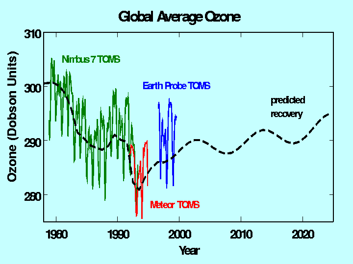
Figure 1. Observed and predicted ozone trends; TOMS (Nimbus-7, Meteor, and Earth Probe) and model predictions that include the known chemical catalytic processes and solar cycles, but not temperature trends in the lower stratosphere which could further slow ozone recovery.
As indicated above, an array of chemical species must be observed in addition to ozone. These include a limited set of long-lived source gases, reservoir species, radicals in the major catalytic cycles and several closely associated meteorological variables such as temperature and winds measured with at least the same spatial and temporal resolution as the gases. Aerosol properties are highly interactive with the chemistry and radiative properties in both the stratosphere and troposphere; therefore their characteristics must also be measured. These data are also needed for accurate trace gas retrieval algorithms. In addition, the total and spectral solar irradiances must be observed to be able to interpret climate and ozone changes. Concerns about air quality and transport of pollution and its precursors on regional to intercontinental scales place an even more stringent demand on observations and models. Figure 2 (from the Harvard University) illustrates model calculations of monthly mean afternoon surface ozone concentrations in July. Particularly noteworthy is pollution over industrial areas in the US, Europe and Asia, with enhancements in Asia due to burning.
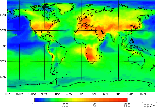
Figure 2. Monthly mean afternoon (1 to 4 PM) surface ozone concentrations calculated for July using Harvard GEOS-CHEM model
The combined requirements for ozone depletion, air quality and
climate research and monitoring are compiled in Table 1 that lists the selected parameters that must be observed frequently.
Tables that document the requirements, for each of these atmospheric
parameters, including spatial and temporal resolution and range,
accuracy, and precision (Threshold and Target) appear in more
detail in the report.
| Parameter | Class | Surface | Total Column |
Lower Trop |
Upper Trop. |
Lower Strat. |
Upper Strat. & Meso. |
| O3 | Mon./Trends | A | A | A | A | A | A |
| O3 | Oper. Met. | A | A | A | |||
| O3 | Air Quality | A | N | N | |||
| O3 | UV Forecasts | A | A | ||||
| Temp | Met. Variable | A | A | A | A | A | |
| Wind | Met. Variable | A | A | ||||
| Tropopause | Met. Variable | A | A | ||||
| Cloud Tops | Met. Variable | A | A | A | |||
| H2O | Source Gas | A | A | A | A | A | A |
| N2O | Source Gas | A | A | A | |||
| CH4 | Source Gas | A | A | N | N | A | A |
| CO | Source Gas | A | A | A | A | ||
| CO2 | Source Gas | A | N | ||||
| HCl | Reservoir | A | A | A | |||
| HNO3* | Reservoir | A | A | A | |||
| BrO | Free Radical | N | N | ||||
| ClO | Free Radical | N | A | A | |||
| NO2* | Free Radical | A | A | N | N | A | A |
| NO* | Free Radical | A | A | N | N | ||
| Aerosol Pres. | Met. Variable | A | A | A | A | A | |
| Aerosol Char. | Met. Variable | A | N | N | A | ||
| PSCs | Met. Variable | A | |||||
| UV | Met. Variable | A | A |
Table 1. Atmospheric parameters that must be measured regularly on a
near global scale: A = available, N = needed
A broad range of operational and research observations are underway and are planned from space and ground. The space missions that will measure total and profile ozone and other atmospheric parameters are illustrated in Figure 3a and b. Data from NOAA, UARS, ERS-2, Terra, ADEOS, WMO-GAW and NDSC, and many aircraft and balloon missions have led to an understanding of atmospheric processes and provided a baseline for evaluating changes in the atmosphere. Upcoming research missions such as ENVISAT and Aura, and operational missions, such as METOP and NPOESS, will provide platforms to continue the baseline measurements, but will only partially satisfy the requirements. TOMS-type data sets are assured until NPOESS, which will continue those measurements. The next two SAGE missions are assured, beginning in 2001, except for the third platform expected later in this decade. UV-VIS-NIR backscatter measurements will continue with GOME-2 on METOP. Follow-on ADEOS and GCOM will also provide collaborative data from space. ODIN, ACE, and SABRE research missions will compliment the larger research and operational missions. To date chemistry measurements have been made from low Earth orbit, but upcoming missions will take advantage of new strategic orbits such as geostationary and Lagrangian to observe diurnal changes for air quality studies.
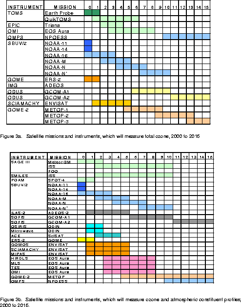
Figure 3. In orbit and planned atmospheric chemistry missions. a) total ozone measurements, b) ozone and chemical constituent profile measurements.
Ground observations (surface, balloon, and aircraft) must continue
and be expanded to provide correlative and validation data for
the satellite missions as well as conducting essential research
observations. The networks such as NDSC and WMO-GAW (e.g. ozone
sonde, Dobson/Brewer, ozone/aerosol lidars, and in situ source
gas stations) must continue to provide data as part of IGOS. Research-driven
aircraft campaigns should continue to study processes in the upper
troposphere and lower stratosphere with high spatial resolution.
The commercial airlines also have a role for providing a platform
for collecting continuous data over a wide geographic area with
high spatial resolution (e.g. MOZAIC). The operational agencies
must play a major role to insure long-term sustainability of these
systems
Calibration and validation are critical to assure the scientific value of remote sensing measurements. They are essential for deriving climate quality data sets. The space faring nations have and must continue to allocate resources for calibration and validation of Earth science missions as is presently being done for ENVISAT and Aura. Both Europe and the United States are now planning operational satellite systems that will carry ozone sounders to extend the long-term record already produced by national research and operational missions. Japan is also committed to fly atmospheric chemistry missions. However, despite the fact that the major space agencies have embarked on these missions, no concurrent long-term validation program, covering the lifetime of these missions is being planned, nor is there any assurance that existing ground-based infrastructure will be in place when they are needed. Satellite systems can only meet the established requirements if they are supported by correlative data of known quality and continually challenged by reliable ground-based observations and quantitative science.
Based on the experience gained from past satellite missions, an end-to-end approach for calibration/validation, highlighting the need for a fully integrated global observing system, to include both ground and space-based measurements, must be established. For satellites this approach includes the internal calibration program, post-launch calibration employing on-board systems, external validation programs using highly controlled correlative measurements, subsequent algorithm refinements and scientific analyses of the data to ensure consistency with the best understanding of atmospheric processes and conditions.
Figure 4 illustrates how these steps are inter-connected. The figure also
demonstrates that end-to-end validation program is a highly iterative
process. The magnitude of the effort demands international pooling
of resources and close collaboration given the existence of parallel
streams of the national operational missions, e.g. the European
METOP and the US NPOESS ozone instruments and corresponding research
missions discussed above.
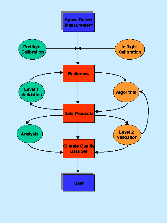
Figure 4. Steps necessary for a space-based measurement to be scientifically
acceptable by the user. Steps include rigorous pre and post launch
calibration, validation, algorithm and data product evaluation,
and subsequent reprocessing.
As discussed above, many of the identified requirements will be met by the existing and planned measurements from ground and space. However, the lack of formal co-ordination among the space faring nations to optimise the deployed systems and to assure compatibility for international users is a serious problem. In addition, there must be formal recognition and support for the international community who are providing critical data from ground-based systems for calibration and validation of the space-borne systems.
The CEOS/WMO report’s recommendations emphasise the missing components of the upcoming systems as well as describe what needs to be improved in the existing systems. The specific recommendations are too detailed for this short summary but are highlighted below. (The SPARC community is encouraged to read the full report available from the WMO):
There is a practical incentive for swift action as an array of
satellite missions with atmospheric instruments are scheduled
for launch during this decade (beginning in 2001) (Figure 3).
The recommendations outlined above attempt to identify those areas
that remain deficient in the present and planned observing systems.
Data collected following the CEOS-IGOS approach will have the
necessary quality to enable the state of the atmosphere to be
reliably monitored and changes understood through supporting research
thereby providing a basis for formulating sound environmental
policies.
![]()