
Results
Seasonal Variations of CO Mixing Ratios and Vertical Profiles
An overall comparison of all three data sets is presented in Fig. 2.
Fig. 2. CO abundance over Alaska in 1995, measured in the boundary layer and in the total atmospheric column. Daily means for Poker Flat and Fairbanks, hourly means for Barrow, vertical bars are standard deviations of single measurements. 16 points for March 15 and 22 in Barrow, when mixing ratios were between 220 and 260 ppb, were omitted as probably local effects.
First, the similarity of boundary layer CO concentrations at Poker Flat and Barrow is quite noticeable. High CO levels, 180-200 ppb, observed in Barrow every spring [Novelli et al., 1994] seem to be at least an Arctic-wide phenomenon. Examination of the time series from 10 sites in the high northern hemisphere show the timing and magnitude of the seasonal maximum are consistent through the Arctic [Novelli et al., 1997]. These are explained by a transport of polluted air from remote populated areas like Russia and Europe to the Arctic, a long lifetime of CO in the Arctic winter- spring, and good horizontal mixing inside the Arctic vortex [Shaw and Khalil, 1989].
Spectroscopically measured tropospheric mean CO mixing ratios were in the range 120 - 150 ppb until the end of April. These can be compared to CO abundances measured by the same technique in March - April in Zvenigorod, near Moscow, Russia, in 1971-1993 and in various sites of the Russian Arctic -n 1982-1988: 140-160 ppb [Yurganov et al., 1995]. Low tropospheric mean in comparison to high boundary layer mixing ratio reflects a decrease of CO mixing ratio with height. Decreasing CO profiles with a difference of 55 ppb between mixing ratios near the surface and tropospheric means have been directly measured by Conway et al. [1993] near Spitsbergen in March, 1989 ( Fig. B1, Appendix B). This type of vertical CO distribution appears to be normal for the Arctic in early spring.
In June, the difference between mixing ratios in the boundary layer and tropospheric means did not exceed 5 ppb. The troposphere was almost uniformly mixed, with mixing ratios decreasing from 120 ppb in the beginning of the month to 90 ppb at the end. In July, the tropospheric average CO mixing ratio fluctuated considerably from day to day and sometimes was higher than the boundary layer value at Barrow. This is in accordance with results of Harris et al. [1994], who measured episodic enhancements of CO mixing ratios up to 500 ppb during the summer months in layers at altitudes between 2 and 5 km over eastern Canada (for an example see Appendix B). Boundary layer concentrations during that experiment were never higher than 150 ppb and usually were close to 100 ppb.
Presented results can be interpreted as follows. In winter, when it is not enough light for the photochemical reactions, man-made CO accumulates in the atmospheric boundary layer of mid/high latitude regions. A strong Arctic temperature inversion minimizes vertical mixing of pollutants. The Arctic vortex limits mixing with cleaner air from lower latitudes (e.g., from the Pacific). In spring, both photochemical CO destruction and vertical mixing increase. As a result, the CO negative vertical gradient, which is typical for winter-early spring, is transformed into a well mixed atmosphere in early summer. During June, the mixing ratio for the entire troposphere approaches a value of around 90 ppb.
In the absence of additional CO sources, the steady state level around 90 ppb could be maintained through the rest of summer until the time when photochemistry declines and man- made CO begins to accumulate again. However, forest fires, which usually occur in Alaska and Canada in July, generate plumes containing combustion by-products. These plumes transport enhanced CO to the altitudes of 2- 5 km (and probably higher). The lifted parcels of polluted air migrate over the continent causing some spikes of CO mixing ratios in Barrow of up to 120 ppb, and enhanced total columns.
Diurnal Variations in Poker Flat and in Fairbanks.
In March - May, 1995, the GFC analyzer was installed at the Poker Flat Research Range 32 km NE of Fairbanks. In late May, the GFC analyzer was moved to Fairbanks and installed side-by- side with the spectrometer. Local pollution sources in Poker Flat appear to be small. The city of Fairbanks, on the contrary, has a population of about 50,000; the Geophysical Institute (GI) is located on the NW boundary of the city on a hill 60 - 80 m above the downtown area.
The diurnal cycles of hourly mean CO mixing ratios, averaged over April-May and June-August, are plotted in Fig.3 a,b, respectively.
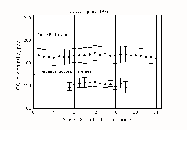 Fig.3a
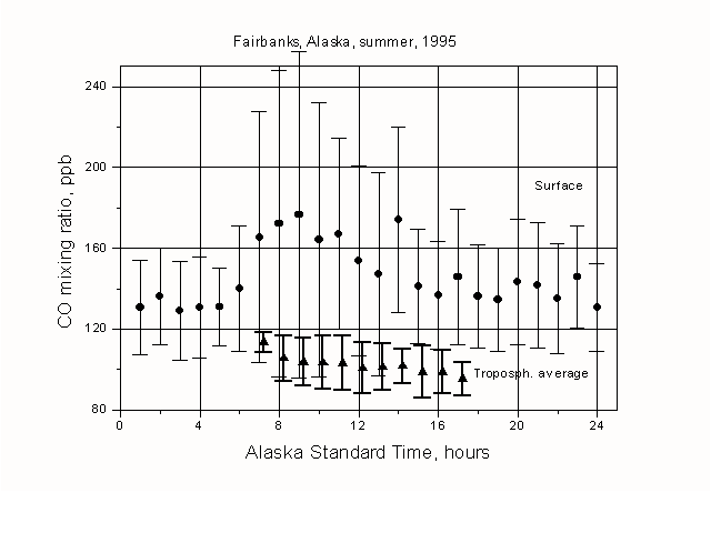 Fig.3b
Fig. 3. Diurnal variations of CO mixing ratio near the surface (GFC) and for the total troposphere (IR solar spectrometer).
a) March 29 - May 30, 1995, GFC analyzer and spectrometer were separated by 32 km. The apparent diurnal cycle of the tropospheric average CO is mostly an artifact of the difference in day light hours between March and May, combined with a seasonal CO decrease during this period.
b) June 1 - August 11, 1995, both instruments were set up in Fairbanks.
There were very small diurnal variations of the boundary layer CO mixing ratio in Poker Flat. On the other hand, a very distinct cycle of CO mixing ratio was observed on the roof of GI, with two maxima, at 9 a.m. and 2 p.m.(Fig. 3b, circles). This cycle can be attributed to variations in automobile exhaust and meteorology conditions. Local pollution resulted in a much larger variability in the Fairbanks boundary layer layer, as compared to Poker Flat .
In contrast to boundary layer data, the tropospheric mean CO mixing ratio, measured spectroscopically (triangles in Fig. 3a, b), did not change significantly during the day. The apparent diurnal cycle in spring is mostly an artifact of the difference in daylight hours between March and May combined with a gradual seasonal CO decline during this period. Local Fairbanks CO sources influence the tropospheric mean abundance much less than the concentration in the boundary layer. However, the lowest detected boundary layer mixing ratios at the roof of GI were very close to the tropospheric means: these were the cases when the air was clean.
An Episode of Frontal Passage
Frontal passages usually are accompanied by clouds and storms. However, we observed a change in air mass during sunny weather on the 22nd of May, 1995. A cold, dry Arctic air mass arrived at Fairbanks on May 20 and the passage of the cold front was associated with a strong thunderstorm. The cold air mass stopped before the Alaska Range (a few hundred km S of Fairbanks). On May 22, it moved northward, and around 4 p.m. the warm front passed Fairbanks during clear sky conditions. CO and water vapor total column abundances are plotted vs time in Fig. 4.
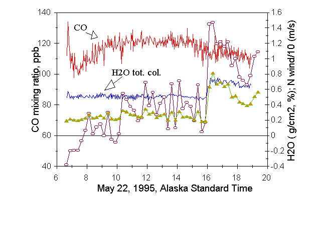
Fig. 4. An example of CO (left scale, tropospheric mean in ppb) and H2O (right scale) total column variations, associated with a frontal passage. Solid lines connect values retrieved from individual spectra. Triangles represent volume H2O mixing ratio in the boundary layer (percent, right scale); circles represent N component of the wind array.
Also presented are the northern component of the wind velocity in m/s (divided by 10, right scale) measured in the boundary layer and the mixing ratio of water vapor in per cent (right scale), measured by a hygrometer (data of the NEWNET station, taken side-by-side with the spectrometer, see http://newnet.jdola.lanl.gov) . The boundary layer CO mixing ratio was not measured in Fairbanks, nor at Poker Flat. A good correlation between boundary layer and total column water vapor densities is obvious. Meanwhile, a difference in CO abundance between the air masses was less than 10 %. This is in accordance with a small day-to-day variability for both boundary layer and total column CO data for Alaska, and confirms our conclusion of an efficient horizontal mixing of CO in the Arctic atmosphere.
Conclusions
1. A progress has been achieved in both local and total column accuracies for CO measurements, providing a consistency between them within several percent. A ground -based total column technique, using the strong R(3) line of CO fundamental band, makes it possible to measure the tropospheric mean mixing ratio directly. A comparison with boundary layer CO mixing ratio gives information on the CO vertical distribution.
2. In central Alaska (and probably in much of the mid/high latitudinal belt) in early spring, the boundary layer is strongly polluted by man-made CO. Atmospheric transport effectively mixes carbon monoxide between midlatitude populated areas and the Arctic.
3. The difference between boundary layer values and the tropospheric average in early spring amounts to 50 ppb. Beginning with mid-April, this difference declines (in other words, the profile of mixing ratio is evolving from decreasing with height to constant with height). By the end of May, the troposphere becomes almost uniformly mixed.
4. In summer we propose that two cases are frequently observed. i) The "undisturbed" troposphere has a constant CO mixing ratio of around 90 ppb. This CO level is determined by photochemistry (methane oxidation, as a source, and OH destruction, as a sink), as well as by long-range transport from populated areas. ii) The troposphere is disturbed by plumes from Alaskan and/or Canadian forest fires. The tropospheric mean may be as high as 120 ppb and local mixing ratios in thin lifted layers may be as high as 300-500 ppb between 2 and 5 km [Harris et al., 1994]. Boundary layer mixing ratios vary between 90 ppb and 120 ppb.