|
|
(1) |
1IFIR (CONICET-Univ. Nacional de Rosario)-2000 Rosario-
Argentina. piacent@ifir.ifir.edu.ar
2Dpto de Física, Univ. Nacional de San Luis-5700
San Luis- Argentina.
3Universitat Innsbruck- Innsbruck- Austria.
4CEILAP (CITEFA-CONICET)- Zufriategui 4380-1603 Villa Martelli-
Pcia. Aires de Buenos -Argentina.
5Universidad Nacional de San Martín- San Martín-
Pcia. De Buenos Aires -Argentina
6Institut Pierre Simon Laplace. Université Paris VI.
Paris. France.
FIGURES
Abstract
The stratospheric ozone profile was determined for the first time over Buenos Aires, Argentina at CEILAP (CITEFA-CONICET) using a differential absorption lidar system. It is composed of two lasers, the excimer one emitting at the ozone absorbing wavelength of 308 nm and the reference Nd:YAG one at 355 nm. The backscattered photons are received in a 50 cm aperture newtonian telescope and analyzed in the detection-acquisition subsystem. When satellite (SAGE II) results are available for the region and measurement period, they are compared with the DIAL ones. The same comparison is made with respect to the ozone profile climatology of TOMS, version 7 (Goddard Space Flight Center-NASA). The stratospheric lidar ozone profiles are included in the pseudospherical DISORT computational code for solving the radiative transfer equation. UV spectral irradiances are obtained in this way. Their relative differences increase with decreasing wavelengths. Also the influence of the ozone profile extend to a larger wavelengths domain at greater zenith angles.
I. Introduction
The ultraviolet solar radiation B (range 280-320 nm) is strongly attenuated by ozone and aerosols (particles in suspension). From December of 1998 and during 1999 and 2000 measurements of profiles of ozone were carried out by means of a DIAL (Differential Absorption Lidar)(1) system, located in the surroundings of Buenos Aires (34.6º S, 58.5º W). In this work the influence of these profiles on the solar irradiances in the range UV (280-400 nm) is analysed.
II. Dial system
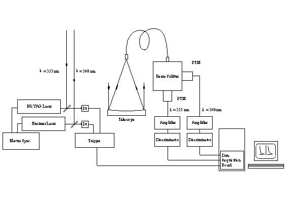
The DIAL system (figure 1) requires two different wavelengths, in this case provided by two lasers, one emitting pulses at l on = 308 nm (ozone absorption) and the other one at l off = 355 nm, providing the reference signal (practically without absorption). The election of these values is based on the commitment of minimizing the statistical and systematic errors in the lower stratosphere(2) .
The backscattering signals of the atmosphere are collected by a Newtonian telescope and detected by fotomultipliers. By means of an external optical synchronism, those signals are acquired alternatively in a photocounting system, and after a numerical treatment the concentration of ozone is determined. For this calculation, the data of temperature and pressure obtained by the radiosound of National Meteorological Service located at Ezeiza Airport (30 Km from CEILAP) and the CIRA for our latitude and the corresponding month are used. More details are given in reference (3).
The DIAL equation determining the concentration of ozone in function of height has two terms(4)
|
|
(1) |
where
|
|
(2) |
is the number of backscattering photons at l
i for an atmospheric layer D z located
at a distance z, during the time of integration D
t, and![]() is the effective cross section
of ozone for l i.
is the effective cross section
of ozone for l i.
![]() ,
,
where: e diff(z), e m(z), e p(z) y e e(z) are the terms for the atmospheric diffusion, the attenuation by molecules, by particles and by others constituents of the atmosphere (excluding the ozone)(5).
III. Ozone vertical profiles
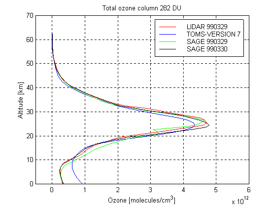
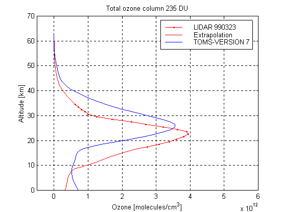
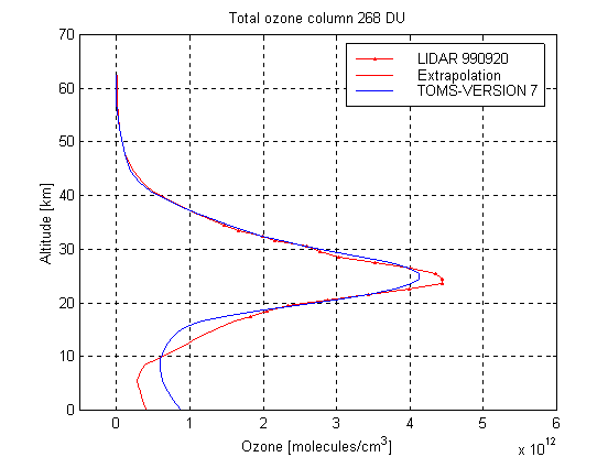
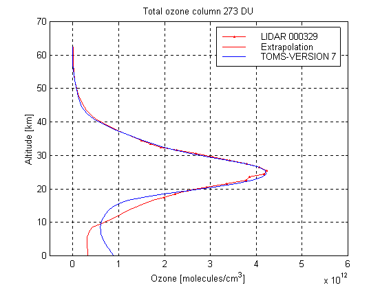
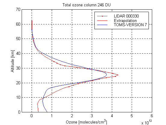
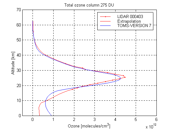
Using this technique ozone vertical profiles have been obtained over Buenos Aires during 1999 and 2000. Figure 2 shows measured typical profiles corresponding to March 23, 1999, March 29 and 30, April 3, 2000 (near the minimum of the layer ) and September 20, 1999 and August 8, 2000 (near the maximum) around the 18 to the 34 Km high
To use these profiles in the calculation of the radiative transfer equation, they should be extended to low and high altitudes. In order to this we connect the profiles measured at CEILAP with the US Standard profile (45° N) used in the pseudo-sphericla DISORT model. The ozone concentration below 18 Km was obtained extrapolating the DIAL profile measured, with the slope of the US Standard profile to each height, using a 150 m step, continuing with this process until the 5 Km. Identical procedure was used to extend the curve beyond 34 Km. The value of superficial ozone considered to continue the curve between the 5 Km and the ground corresponds to the mean-monthly of Buenos Aires for March and September respectively (6).
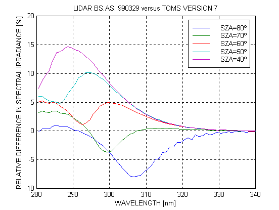
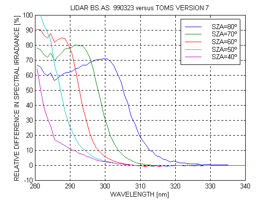
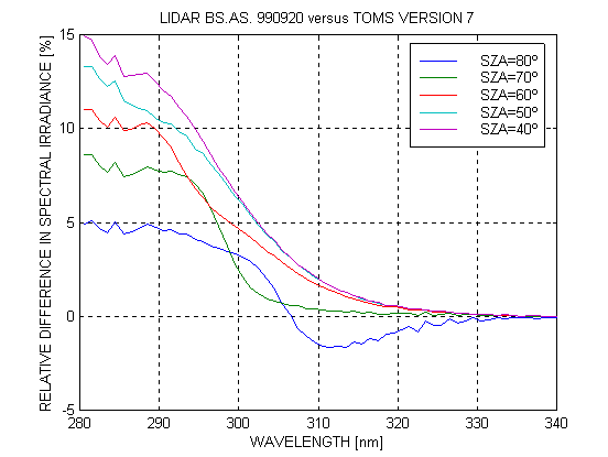
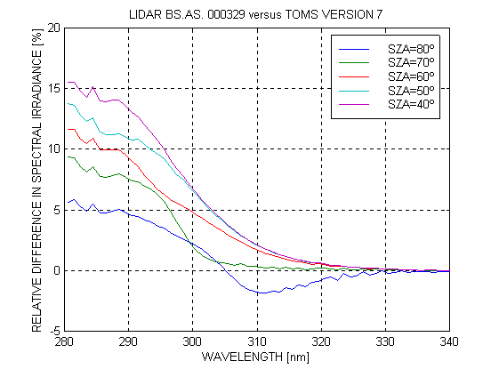
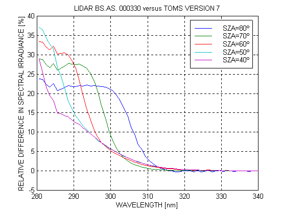
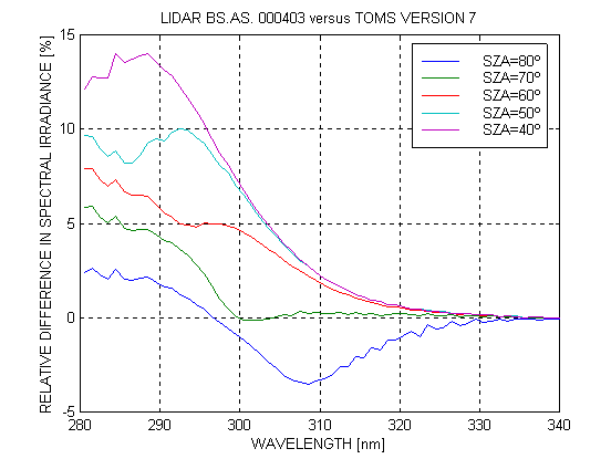
The lidar extended ozone profiles corresponding the days mentioned above, were integrated in order to obtain the total ozone value.Then, TOMS climatology profiles were selected in order to better adjust these ozone value. Both types of profiles were introduced in the DISORT alghoritm in order to determine the corresponding irradiance with the following atmospheric parameters: coefficients of attenuation of aerosols a = 1 and b = 0.1, ground reflectivity (albedo) = 0.1, clear sky, pressure corresponding to 15 m height (practically the normal one). The results displayed in figure3 for different solar zenith angles, show that the relative difference in spectral irradiances increase in general with decreasing wavelength The largest difference at 300 nm is of about 30% andoccurs for solar zenith angle of 70º It orginates in the different behavior of the ozone profile at all levels.
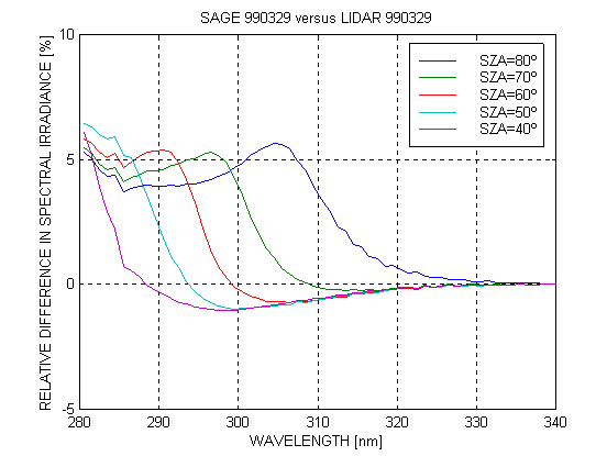
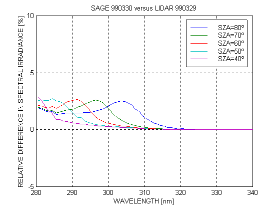
Also lidar profiles were compared with SAGE II and TOMS ones. In particular, the SAGE II ozone profile corresponding to March 29, 1999 (21:50 UT) at coordinates (36.1º S, 59ºW) and to March 30, 1999 (31º S, 50.2º W) are compared with the lidar and TOMS profiles measured in between (seefigure 4). Again, the relative difference between both irradiances varies with wavelength in the same form. In this way it is shown that DIAL profiles could be an important reference option in atmospheric research (figure 5).
The integration of radiative transfer equation allows to obtain spectral irradiances indicated in figure 3, in the range UVA (320400 nm) as in the UVB (280320 nm) for days near to autumn equinoxes, when the ozone layer has approximately the minimum value, and for that of spring , when its maximum arrives. It has been adopted the DIAL profile measured at CEILAP as indicated in figure 2
At table 1 (related to figure 3) the erythemal solar irradiances are given (directly related with the Solar Risk Index through the factor 40) for different daytimes (different zenithal angles, corresponding to the smallest value at noon of the considered day). It is observed that the integrated values shows very little difference each other (last column) except for the biggest zenithal angle considered of 80º on March 23, 1999, when the Sun is near to the horizon and its intensity is very low. A similar relation is displayed in table 2 for data related to figure 5.
IV. Conclusion
In summary the results are:
- Measurements of stratospheric ozone profiles using DIAL technique during 1999 and 2000 and for the first time on Buenos Aires.
- Relative differences of solar spectral irradiance obtained from the equation of radiative transfer, including the measured profiles and the TOMS and SAGE II ones. To detect these differences an spectroradiometer in the range UVB must be used.
V. Appendix . Solar UV Irradiance.
The radiation intensity incident on a given surface has two terms:
|
|
(A1) |
representing the direct component of UV photons arriving from the Sun without any deviation and
|
|
(A2) |
the diffuse component of photons arriving from all directions. The variable z includes factors characterizing the geographical place (coordinates and height of the place and ground reflectivity), the solar zenithal angle q z and the atmospheric components affecting the considered radiation (aerosols, ozone and other gases). The first one is given by the law of exponential attenuation and the second (transforming the variable wavelength in frequency) through the solution of the equation of radiative transfer:
|
|
(A3) |
where s is the trajectory of the incident radiation beam and W
the solid angle associated with this radiation and the considered point.
![]() is the spectral extinction
coefficient and
is the spectral extinction
coefficient and ![]() the spectral
source function, given respectively by:
the spectral
source function, given respectively by:
|
|
(A4) |
|
|
(A5) |
|
|
|
(A6) |
|
|
(A7) |
being p the scattering phase function, ![]() y
y
![]() spectral absorption and
dispersion coefficients respectively and
spectral absorption and
dispersion coefficients respectively and ![]() the
spectral albedo (reflectivity). The formula (A7) expressed
the very well-known Planck¹s law of the blackbody radiation.
the
spectral albedo (reflectivity). The formula (A7) expressed
the very well-known Planck¹s law of the blackbody radiation.
The spectral irradiances in UV range (280 - 400 nm) is obtained with the following expression:
|
|
(A8) |
With the integration of this expression the UV solar total irradiance is:
|
|
(A9) |
The erythemal irradiance is obtained using a factor of weight, called erythemal action spectrum (skin alarm), B(l ) to the UV irradiance given for (A8).
|
|
(A10) |
And expressed in SI units and multiplied by the factor 40, gives the Index of Solar Risk (UV Index) at any time during the day.
Figures 3 and 4 and table 1 shows the results obtained using formulas (A8 - A10) for different days and ozone profiles.
Acknowledgements
The authors thanks to Dr. Jim Russell of the SAGE II team, and to the members of the Laboratory for Atmosphere, Goddard Space Flight Center/NASA, for the interesting exchanges of information of ozone profiles from SAGE II and of the algorithm TOMS respectively. To Pablo García of Rosario's Astronomical Observatory for his computational collaboration and to the Engineer M. Ginzburg of the SMN for the data of total ozone of the spectrometer Dobson. The present work has partial support from ANCYPT, CONICET, the U. N. Rosario, UNSAM and U. N. San Luis.
References
1. Megie, G., Menzies, R. T. Complementary of UV and to GO Differential Absorption Lidar for Global Measurements of Atmospheric Species. Appl. Opt., 19, 1173 (1980).
2. Godin, S. Etude Experiences him even Télédétection Laser et Modélisation of the Distribution Verticale d'Ozone dans the Haute Province, Thèse d'Etat, Paris (1987).
3. Pazmiño A. F., Lavorato M. B., Fochesatto G. J., Ristori P. R., Cesarano P. A., Quel E. J., Godin S., Megie G. System DIAL for the mensuration of the profile of ozone estratosférico, Annals AFA99, 11, 338 (1999).
4. Measures R. M. Láser Remote Sensing Fundamentals and Applications", Wiley, Interscience (1984).
5. Labitzke, K., Barnett, J. J., Edwards, B. "Middle Atmosphere Program. Handbook for Map", 16 (1985).
6. McKinlay, A. F. and Diffey B.L., Human Exposure to UV Radiation: Risk and Regulations Ed. Elsevier (1987).
Table 1. Erythemal irradiances (IERY), indicative of solar risk, and their relative differences calculated solving the radiative transfer equation using the profile measured with laser (DIAL) in CEILAP, Buenos Aires on different days of 1999 and 2000 and that of TOMS, for different solar zenith angle (SZA). (back)
|
|
SZA |
IERY LIDAR |
IERY TOMS |
IERYDIFF (%) |
| 3/23/1999 |
80 |
8.3 |
7.6 |
9.0 |
| 3/23/1999 |
70 |
29.0 |
28.5 |
1.8 |
| 3/23/1999 |
60 |
70.1 |
69.8 |
0.4 |
| 3/23/1999 |
50 |
132.2 |
131.7 |
0.4 |
| 3/23/1999 |
40 |
208.5 |
207.3 |
0.6 |
| 9/20/1999 |
80 |
6.7 |
6.7 |
-0.5 |
| 9/20/1999 |
70 |
24.5 |
24.4 |
0.3 |
| 9/20/1999 |
60 |
59.9 |
51.1 |
1.4 |
| 9/20/1999 |
50 |
113.0 |
110.7 |
2.1 |
| 9/20/1999 |
40 |
178.2 |
173.9 |
2.5 |
| 3/29/2000 |
80 |
6.6 |
6.7 |
-0.6 |
| 3/29/2000 |
70 |
24.3 |
24.2 |
0.2 |
| 3/29/2000 |
60 |
59.2 |
58.4 |
1.4 |
| 3/29/2000 |
50 |
111.7 |
109.4 |
2.1 |
| 3/29/2000 |
40 |
176.2 |
171.8 |
2.5 |
| 3/30/2000 |
80 |
7.4 |
7.3 |
1.6 |
| 3/30/2000 |
70 |
27.2 |
27.0 |
0.7 |
| 3/30/2000 |
60 |
66.8 |
65.9 |
1.3 |
| 3/30/2000 |
50 |
126.4 |
124.0 |
1.9 |
| 3/30/2000 |
40 |
199.5 |
195.1 |
2.3 |
| 4/3/2000 |
80 |
6.5 |
6.6 |
-1.1 |
| 4/3/2000 |
70 |
24.0 |
24.0 |
0.1 |
| 4/3/2000 |
60 |
58.6 |
57.8 |
1.4 |
| 4/3/2000 |
50 |
110.6 |
108.2 |
2.3 |
| 4/3/2000 |
40 |
174.4 |
169.8 |
2.7 |
| 8/29/2000 |
80 |
5.5 |
5.5 |
-0.6 |
| 8/29/2000 |
70 |
18.9 |
18.9 |
0 |
| 8/29/2000 |
60 |
44.9 |
44.6 |
0.6 |
| 8/29/2000 |
50 |
83.4 |
82.6 |
1 |
| 8/29/2000 |
40 |
130.7 |
129.1 |
1.3 |
Table 2. Erythemal irradiances (IERY), indicative of solar risk, and their relative differences calculated solving the radiative transfer equation using the profile measured with laser (LIDAR) in CEILAP, Buenos Aires on March 30, 1999 and that of TOMS for the same day, for different solar zenith angle (SZA). Also, these are compared with SAGE II profiles from March 29, 1999 (SAGE1) and March 30, 1999 (SAGE2). (back)
|
|
IERY LIDAR |
IERY SAGE1 |
IERY SAGE2 |
IERY TOMS |
DIFF LIDAR-TOMS |
DIFF SAGE1-TOMS |
DIFF SAGE2-TOMS |
DIFF SAGE1-LIDAR |
DIFF SAGE2-LIDAR |
|
80 |
6.3 |
6.4 |
6.3 |
6.4 |
-2.2 |
-1.1 |
-1.9 |
1.1 |
0.3 |
|
70 |
23.2 |
23.2 |
23.2 |
23.1 |
0.1 |
0.1 |
0.2 |
0 |
0.1 |
|
60 |
56.7 |
56.5 |
56.7 |
55.7 |
1.8 |
1.4 |
1.9 |
-0.4 |
0.1 |
|
50 |
107.0 |
106.5 |
107.1 |
104.1 |
2.8 |
2.3 |
2.9 |
-0.5 |
0.1 |
|
40 |
168.8 |
167.9 |
169.0 |
163.5 |
3.4 |
2.7 |
3.4 |
-0.5 |
0.1 |
Figure 1. Setup of the differential absorption lidar (DIAL) for the measurement of stratospheric ozone profiles installed at CEILAP, Villa Martelli, Great Buenos Aires. (back)
 |
 |
 |
 |
 |
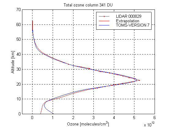 |
Figure 2. Ozone profiles measured over Buenos Aires with the DIAL technique at CEILAP between the 18 and 34 km high and ozone profiles climatology of TOMS. The Lidar profiles are extended with the US Standard ozone profile, as explained in the text. The profiles correspond to March 23 and September 20, 1999 and March 29, 30, April 3 and August 8, 2000. (back)
 |
 |
 |
 |
 |
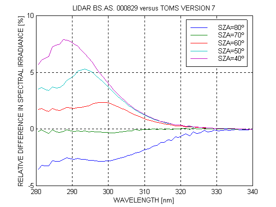 |
Figure 3 The relative difference in spectral irradiances between the Lidar measurement for the selected days and the TOMS profiles. (back)
Figure 4. Comparison between Lidar, SAGE II and TOMS ozone profiles. In particular, the SAGE II ozone profile corresponding to March 29, 1999 (21:50 UT) at coordinates (36.1º S, 59ºW) and to March 30, 1999 (9.30 UT) at coordinates (31º S, 50.2º W). (back)
|
|
|
|
|
|
Figure 5. Relative difference in spectral irradiances between Lidar-SAGE 990329 (a), Lidar-SAGE 990330 (b) and Lidar-TOMS (c). (back)
Back to
| Session 1 : Stratospheric Processes and their Role in Climate | Session 2 : Stratospheric Indicators of Climate Change |
| Session 3 : Modelling and Diagnosis of Stratospheric Effects on Climate | Session 4 : UV Observations and Modelling |
| AuthorData | |
| Home Page | |