Previous: Dial system Next: Conclusion Up: Ext. Abst.
III. Ozone vertical profiles
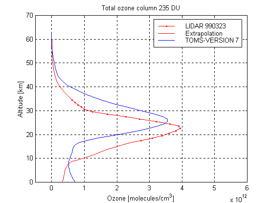
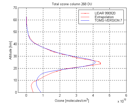
Using this technique ozone vertical profiles have been obtained over Buenos Aires during 1999 and 2000. Figure 2 shows measured typical profiles corresponding to March 23, 1999, March 29 and 30, April 3, 2000 (near the minimum of the layer ) and September 20, 1999 and August 8, 2000 (near the maximum) around the 18 to the 34 Km high
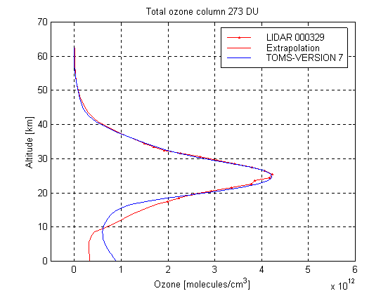
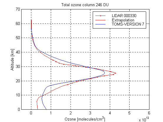
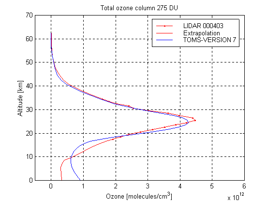
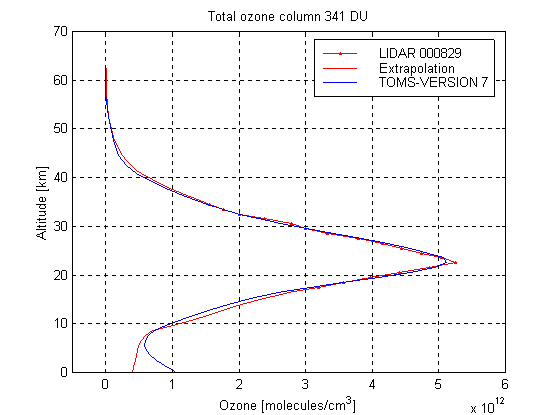
Figure 2. Ozone profiles measured over Buenos Aires with the DIAL technique at CEILAP between the 18 and 34 km high and ozone profiles climatology of TOMS. The Lidar profiles are extended with the US Standard ozone profile, as explained in the text. The profiles correspond to March 23 and September 20, 1999 and March 29, 30, April 3 and August 8, 2000.
To use these profiles in the calculation of the radiative transfer equation, they should be extended to low and high altitudes. In order to this we connect the profiles measured at CEILAP with the US Standard profile (45° N) used in the pseudo-sphericla DISORT model. The ozone concentration below 18 Km was obtained extrapolating the DIAL profile measured, with the slope of the US Standard profile to each height, using a 150 m step, continuing with this process until the 5 Km. Identical procedure was used to extend the curve beyond 34 Km. The value of superficial ozone considered to continue the curve between the 5 Km and the ground corresponds to the mean-monthly of Buenos Aires for March and September respectively (6).
The lidar extended ozone profiles corresponding the days mentioned above, were integrated in order to obtain the total ozone value.Then, TOMS climatology profiles were selected in order to better adjust these ozone value. Both types of profiles were introduced in the DISORT alghoritm in order to determine the corresponding irradiance with the following atmospheric parameters: coefficients of attenuation of aerosols a = 1 and b = 0.1, ground reflectivity (albedo) = 0.1, clear sky, pressure corresponding to 15 m height (practically the normal one). The results displayed in figure3 for different solar zenith angles, show that the relative difference in spectral irradiances increase in general with decreasing wavelength The largest difference at 300 nm is of about 30% andoccurs for solar zenith angle of 70º It orginates in the different behavior of the ozone profile at all levels.
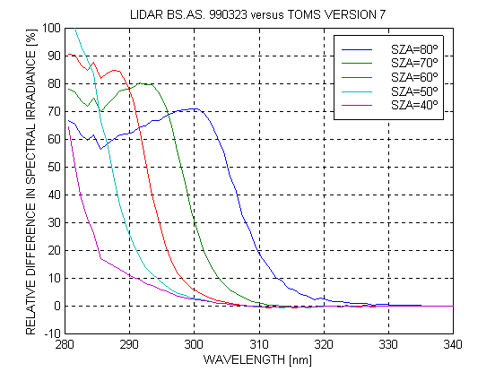
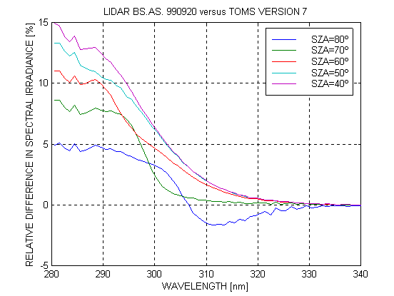
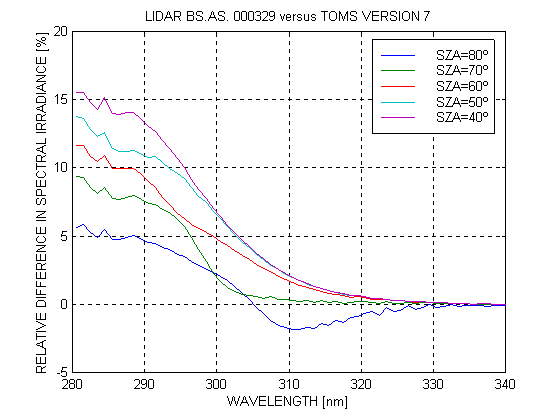
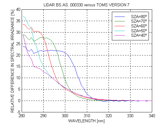
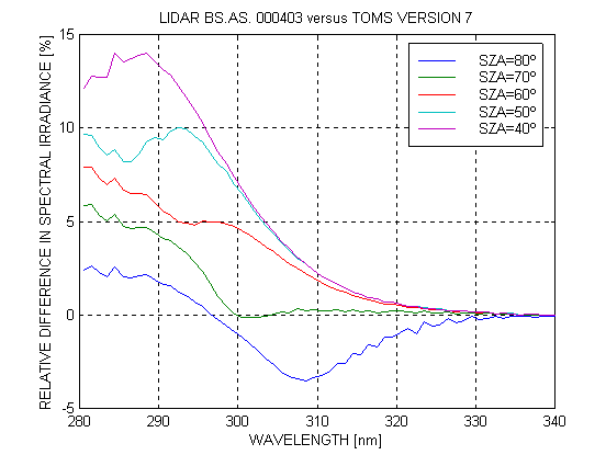
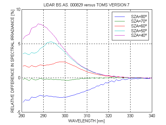
Figure 3 The relative difference in spectral irradiances between the Lidar measurement for the selected days and the TOMS profiles.
Also lidar profiles were compared with SAGE II and TOMS ones. In particular, the SAGE II ozone profile corresponding to March 29, 1999 (21:50 UT) at coordinates (36.1º S, 59ºW) and to March 30, 1999 (31º S, 50.2º W) are compared with the lidar and TOMS profiles measured in between (see figure 4). Again, the relative difference between both irradiances varies with wavelength in the same form. In this way it is shown that DIAL profiles could be an important reference option in atmospheric research (figure 5).
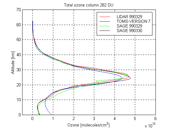
Figure 4. Comparison between Lidar, SAGE II and TOMS ozone profiles. In particular, the SAGE II ozone profile corresponding to March 29, 1999 (21:50 UT) at coordinates (36.1º S, 59ºW) and to March 30, 1999 (9.30 UT) at coordinates (31º S, 50.2º W).
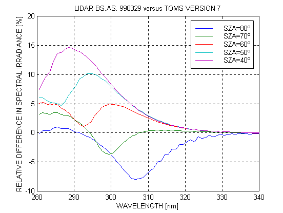
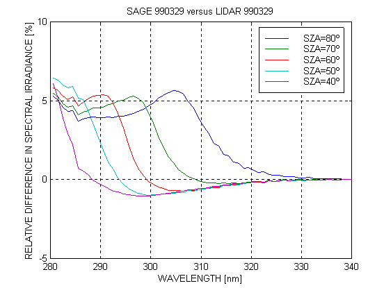
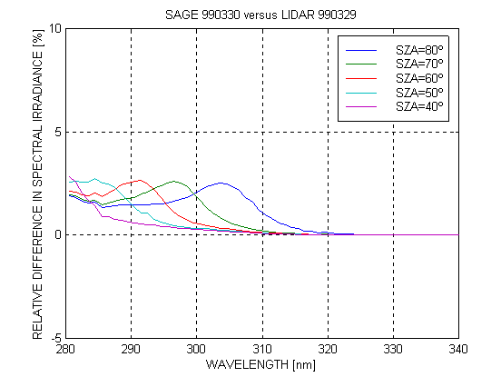
Figure 5. Relative difference in spectral irradiances between Lidar-SAGE 990329 (a), Lidar-SAGE 990330 (b) and Lidar-TOMS (c).
The integration of radiative transfer equation allows to obtain spectral irradiances indicated in figure 3, in the range UVA (320400 nm) as in the UVB (280320 nm) for days near to autumn equinoxes, when the ozone layer has approximately the minimum value, and for that of spring , when its maximum arrives. It has been adopted the DIAL profile measured at CEILAP as indicated in figure 2
At table 1 (related to figure 3) the erythemal solar irradiances are given (directly related with the Solar Risk Index through the factor 40) for different daytimes (different zenithal angles, corresponding to the smallest value at noon of the considered day). It is observed that the integrated values shows very little difference each other (last column) except for the biggest zenithal angle considered of 80º on March 23, 1999, when the Sun is near to the horizon and its intensity is very low. A similar relation is displayed in table 2 for data related to figure 5.
Table 1. Erythemal irradiances (IERY), indicative of solar risk, and their relative differences calculated solving the radiative transfer equation using the profile measured with laser (DIAL) in CEILAP, Buenos Aires on different days of 1999 and 2000 and that of TOMS, for different solar zenith angle (SZA).
Table 2. Erythemal irradiances (IERY), indicative of solar risk, and their relative differences calculated solving the radiative transfer equation using the profile measured with laser (LIDAR) in CEILAP, Buenos Aires on March 30, 1999 and that of TOMS for the same day, for different solar zenith angle (SZA). Also, these are compared with SAGE II profiles from March 29, 1999 (SAGE1) and March 30, 1999 (SAGE2).