Previous: Introduction Next:The Antarctic Vortex Up: Ext. Abst.
The Arctic Vortex
Minimum temperatures
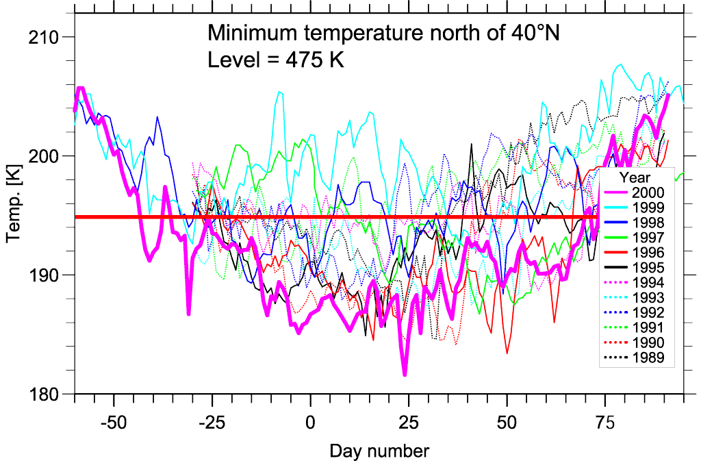
The minimum temperature anywhere north of 40°N has been used by several investigators as a parameter to characterise the temporal development of the polar vortex through the winter. Figure 1 shows how this parameter has evolved during individual winters for the last twelve years. It is seen from the figure that the winter 1999-2000 (thick curve in magenta) for certain periods is colder than any of the previous winters shown here. One can also see that the winter before (1998-99) had some of the warmest minimum temperatures during this 12 year time span.
Figure 1. Minimum temperatures north of 40°N. This parameter is calculated by looking through the ECMWF temperature field north of 40°N and picking out the grid point with the lowest temperature. This is done for every day throughout the winter. The plot shows Tmin for every day for the 12 winters from 1988/89 through 1999/00. The thick red horizontal line shows the NAT threshold temperature at 475 K.
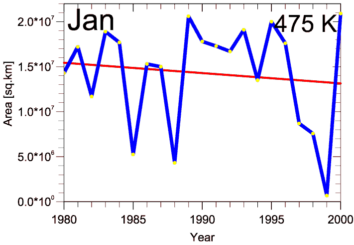
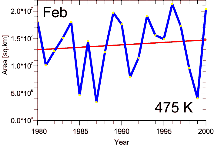
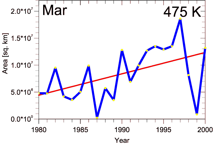
It will be of interest to study if this minimum temperature shows a trend during the 21-year period from 1980-2000. For this we have picked out the lowest temperature in the ECMWF field for any day and any place for each month. Based on this we have plotted the January, February, March and April minimum for each of the 21 winters. The results are shown below in Figure 2. As shown in Table 1 there is no significant trend in this parameter for January or February. For March the trend is -0.16%/year with a 1s uncertainty of 0.07%/year. This means that the trend is significant to better than 2 s. For April the trend is -0.10 ± 0.05%/year, also significant to the 2s level. It is seen from the figure that January of 2000 had the lowest temperature ever recorded in January since 1980 and that January of 1999 had the highest monthly minimum during this period.
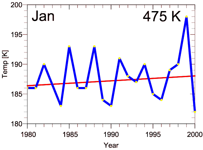
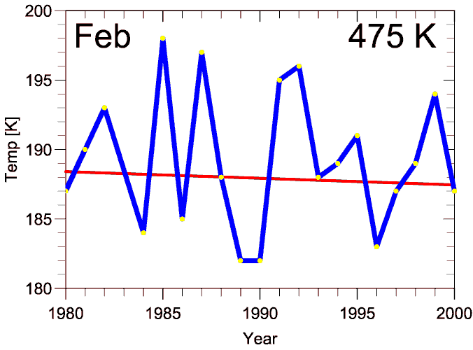
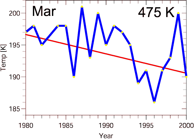
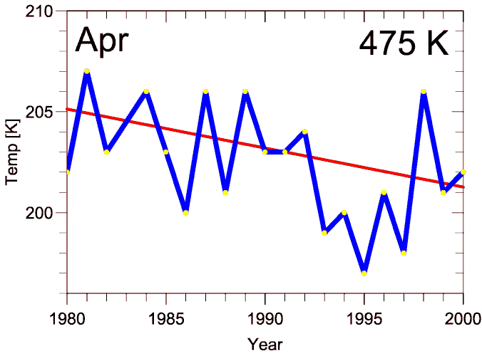
Figure 2. The minimum temperatures north of 40°N for any day during the respective months. The blue curve shows the monthly minimum for each year and the red curve is a linear least squares fit to the data. For January and February there is no significant trend, but for March and April there is a trend that is significant within 2 s(see text above and Table 1).
Vortex area
The area of the polar vortex can be used as a quantity to describe the evolution of the vortex. We have calculated the monthly mean vortex area defined as the area where PV > 42·10-6 Km2/kgs at 475 K. The trend in these monthly means is shown in Figure 3. For January it can be seen that the highest monthly mean vortex area was reached in 2000 with an area of 2.09·107 km2 (1989 was close with 2.06·107) It can also be seen that 1999 had the smallest January vortex during this 21-year period. The plot for February shows that 1996 has the largest vortex and that 1987 had the smallest. In March, and esp. in April, it becomes apparent that the 1997 vortex was quite unique in terms of stability late into the spring. These plots show that there is a clear tendency towards longer-lived Arctic vortices and the trend for both March and April are significant well above the 2s level (see Table 1).
 |
 |
 |
|
Figure 3. Area of the Arctic vortex. The plots show the monthly mean area of the region where PV > 42·10-6 Km2/kgs. The blue curve shows the monthly mean for each year and the red curve is a linear least squares fit to the data. There is no significant trend for January nor February, but it is significant within 2 sfor March and April.
Mean potential vorticity
The mean PV value inside the vortex (defined as PV > 36 PVU in this case) can be used as a parameter to study the stability or strength of the vortex. We have calculated vortex monthly mean PV values for the 21 years studied here. The trend in this parameter is shown in Figure 4. For January there is no significant trend, but for February the trend is significant within the 1s limit. The very weak vortex of 1999 can be seen from all four panels. Both March and April show positive trends that are well above the 2s level (see Table 1)
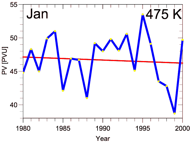
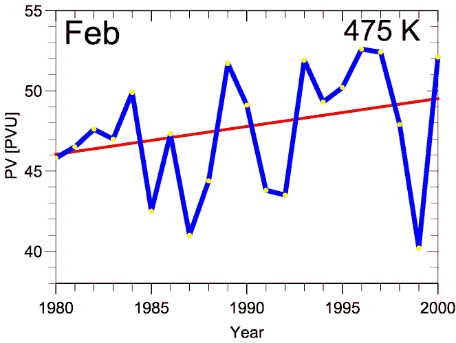
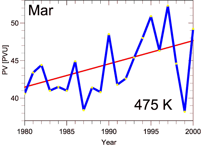
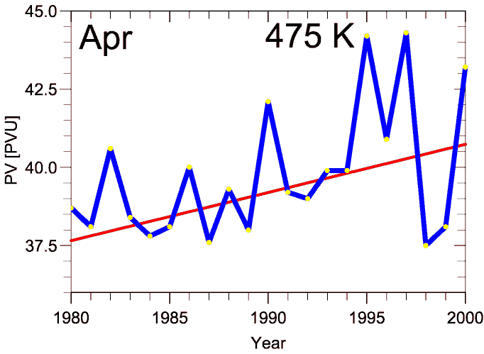
Figure 4. Monthly average potential vorticity for the Arctic vortex. The vortex is defined as the region where PV > 36·10-6 Km2/kgs. The blue curve shows the monthly mean for each year and the red curve is a linear least squares fit to the data. There is no clear trend for January nor February. For March and April there is a clearly increasing trend that is significant within 2 s(see Table 1)
Vortex strength
Figure 5 shows a parameter that combines the vortex area and the PV strength. One also gets an impression of the longevity of the polar vortex for the last 21 winters. One can see a tendency towards more long-lived vortices during the last years. This extends the possible period for ozone depletion, either through halogen chemistry if the temperature is low enough, or through NOx chemistry if the vortex lasts well into spring (such as in 1997)
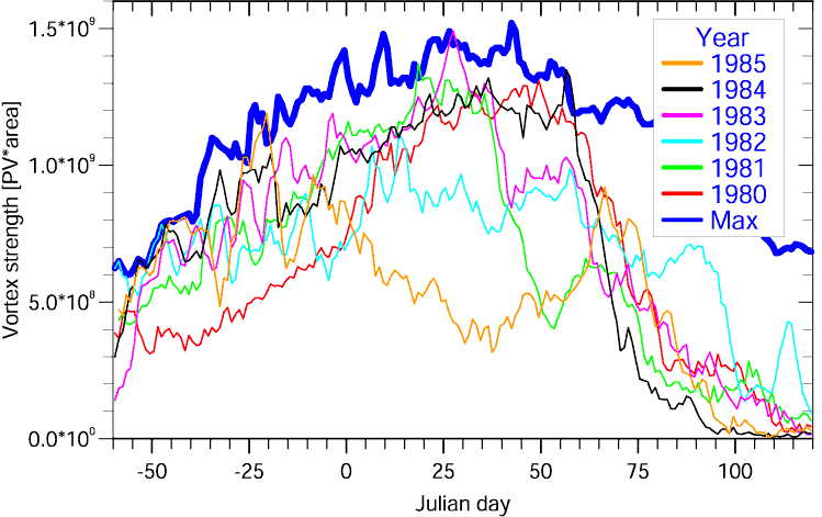
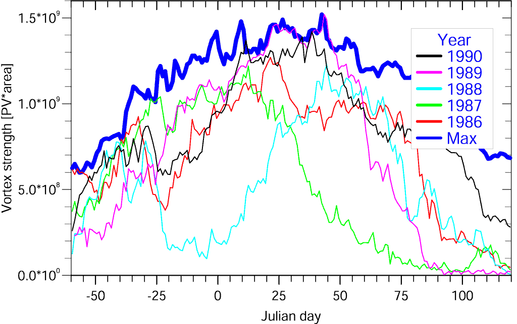
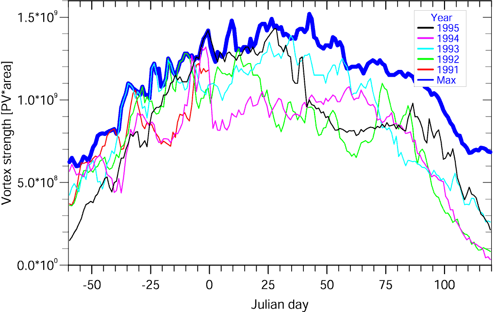
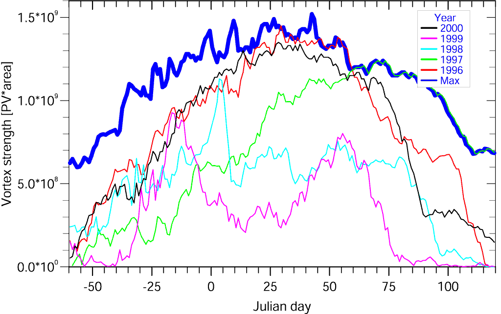
Figure 5. Vortex strength. This parameter is PV·area for all grid cells where PV > 36·10-6 Km2/kgs. The upper left panel shows the temporal development of this parameter for the winters from 1979/80 to 1984/85, the upper right panel for 1985/86 until 1989/90, the lower left panel from 1990/91 to 1994/95 and the lower right panel for the winters 1995/96 to 1999/00. The thick blue curve represents the maximum vortex strength for each day during the 1979/80 - 1999/00 time period.
The monthly mean values of the vortex strength parameter have been calculated and the resulting trends are shown in Figure 6. There are no significant trends for January nor February, but for March the trend is 2.7%/year with better than 2s confidence.
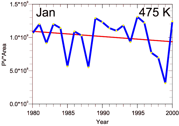
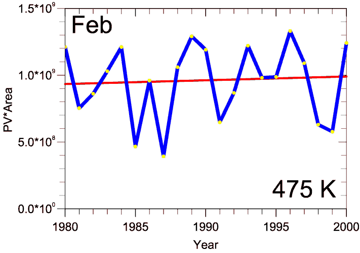
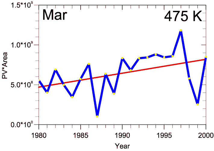
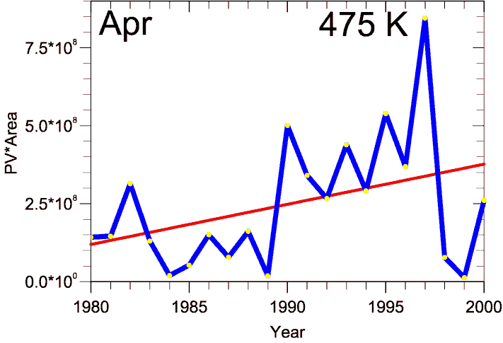
Figure 6. Vortex strength defined as PV·Area for all grid cells where PV > 36·10-6 Km2/kgs. The plots show monthly average values for the four months January - April. The blue curve shows the monthly mean for each year and the red curve is a linear least squares fit to the data.
PSC area
The geographical area with temperatures low enough for PSC type I condensation is often used as a proxy for the degree of activation. Figure 7 shows the temporal behaviour of this parameter as a function of date throughout the 21 winters from 1979-80 to 1999-00. From these plots one can see a tendency towards more winters with NAT temperatures through most of the winter from December to March. The winters of 1995-96 and 1999-2000 stand out as particularly cold with NAT temperatures from early winter into the late winter
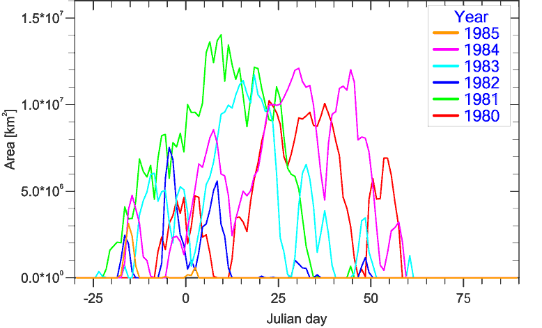
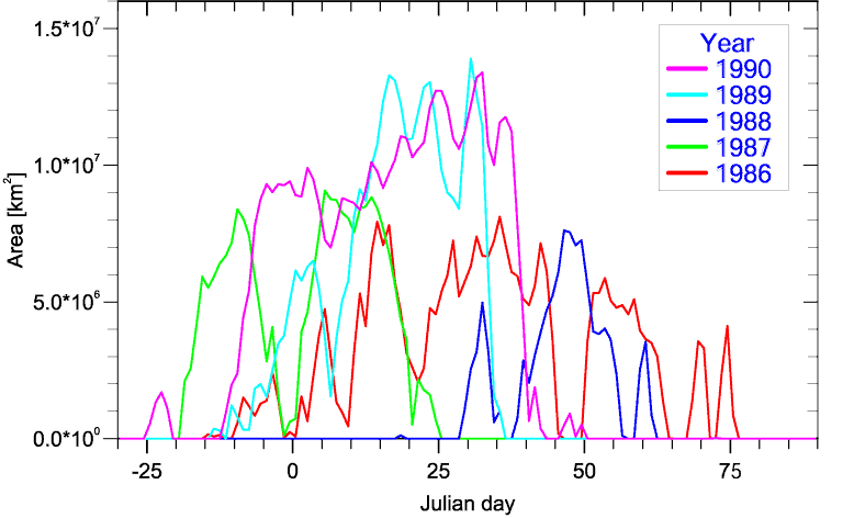
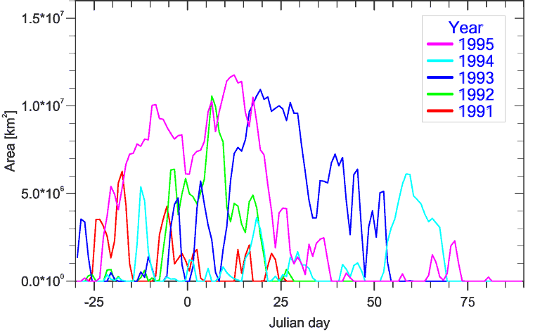
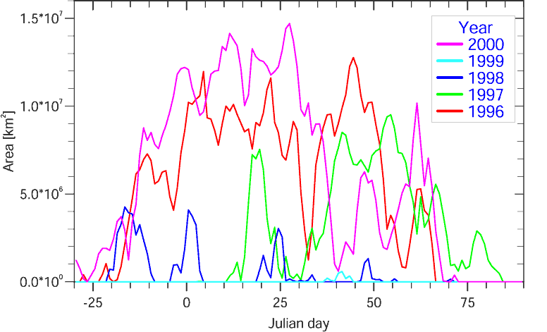
Figure 7. Area (km2) of region where the temperature is below the NAT limit (approx. 195 K at 475 K). This parameter has been plotted as a function of the date throughout the 21 winters from 1979-80 to 1999-00. The upper left panel shows the time period from 1979-80 to 1984-85. The upper right panel shows the time period from 1985-86 to 1989-90. The lower left panel shows the time period from 1990-91 to 1994-95. The lower right panel shows the time period from 1995-96 to 1999-00. One can clearly see an increasing tendency towards occurrence of NAT temperatures into the late winter.
From Figure 7 one can clearly see a tendency towards increasing occurrence of NAT temperatures into the late winter. The first six years (upper left panel) had no NAT temperatures after day 62. During the next ten winters there are several episodes with NAT temperatures until day 77. During the last five winters (lower right panel) there have been episodes with NAT temperatures until day 84. Occurrence of PSCs in the late winter will lead to more ozone loss than a similar amount of PSCs earlier in the winter due to longer days and hence more exposure to sunlight. If this trend continues there is a risk for more severe spring ozone loss in the future.
We have calculated monthly mean PSC areas for each of the four months for the 21 years from 1980 to 2000. The trend in this parameter is shown in Figure 8. The trends for January and February are not significant and the interannual variability is very high throughout the 21-year period. It can be seen that January 2000 has the largest monthly PSC area for any year and month. For March there is a clear positive trend of 14% per year and it is significant at the 2 slevel
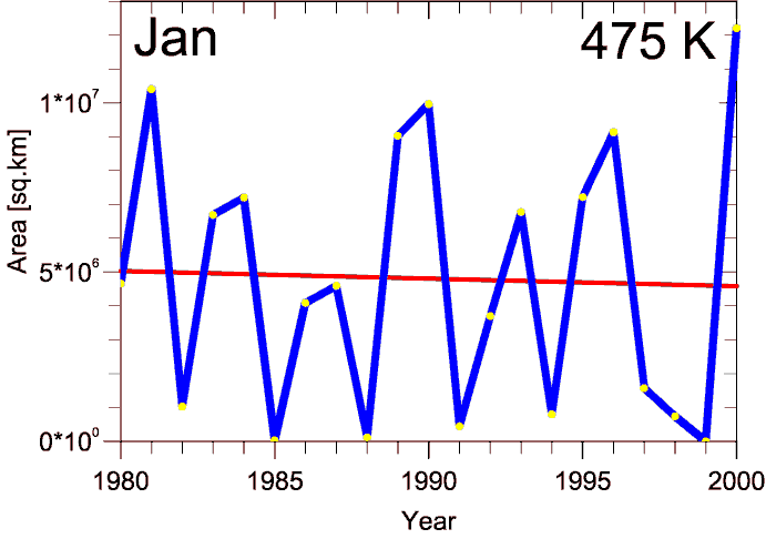
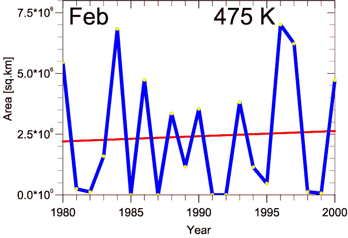
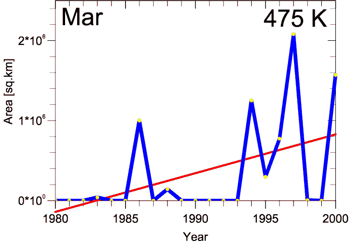
Figure 8. Monthly mean values of the area with temperatures low enough for
formation of NAT PSCs. The temperature limit is approx. 195 K,
depending on the atmospheric pressure. There is no significant
trend for January and February, but the trend is significant for
March.
Trend calculations
The trends have been calculated as linear least squares fits. The results are given in Table 1. The uncertainties given in the table are one standard deviation.
Table 1. Linear trends (% per year)
Parameter
Jan
Feb
Mar
Apr
Min. temp.
0.04 ± 0.08
-0.02 ± 0.10
-0.16 ± 0.07
-0.10 ± 0.05
Vortex area
-0.8 ± 1.5
0.7 ± 1.5
4.7 ± 1.9
9.6 ± 4.5
Mean PV
-0.1 ± 0.2
0.36 ± 0.29
0.69 ± 0.29
0.38 ± 0.17
Vortex strength
-0.8 ± 1.0
0.3 ± 1.1
2.7 ± 1.3
5.2 ± 2.9
PSC Area
-0.46 ± 3.06
0.87 ± 3.92
14.0 ± 5.9
no PSCs