Previous: Analysis Method Next: Characteristics of the temperature variations Up: Ext. Abst
Comparisons with FUB data
FU Berlin monthly mean temperatures are available only for the northern hemisphere. They are deduced from daily analyzed temperatures for 00:00 UTC, which result from a subjective analysis, using over land the radiosonde observations and over sea the routinely-transmitted SATEMs (i.e. thicknesses derived from SSU) and assuring a backward time consistency (Pawson and Naujokat, 1997). The procedure used for performing the comparisons at a spatial resolution of 5° lat x 5° lon (which is the FUB data resolution) has been discussed in Claud et al, 1999.
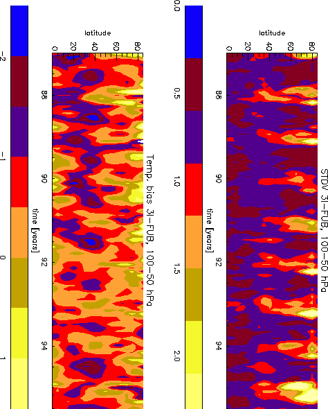
Figure 1 shows the zonal mean bias (Bottom) and the standard deviation (Top) for the temperature difference 3I - FUB as a function of time (month) for the 100-50 hPa layer. The bias is found generally negative (3I less then FUB), with larger values at the end of the spring for latitudes centered at about 40 °N. However, there is some interannual variability, and the differences are on average smaller during the '92-'93 period, which are the years which follow the Pinatubo eruption. The standard deviation (Fig. 1b) is maximum for high latitudes during the winter months in relationship with the larger dynamical range of the temperatures over these areas during this period. In summer standard deviation values are more homogeneous independently of the latitudes.
Figure 1 : Zonal mean bias (Bottom) and standard deviation (Top) for the temperature difference 3I-FUB versus time in 100-50 hPa layer
The standard deviation pattern for the 50-30 hPa and 30-10 hPa layers (not shown) is similar to that presented in Fig.1a; in the 50-30 hPa layer, the largest differences are observed in tropical and subtropical areas during wintertime.
Comparisons have also been performed separately over sea and over land showing a slightly better agreement over land, i.e. where FUB data rely mostly on radiosoundings both in terms of bias and standard deviation.
Values of the standard deviation (less than 2.5 K) and of the bias (in the range -3; 2 K) demonstrates the good quality of the data; in addition it shows the overall continuity of the satellite products (before August 91, NOAA-10 data were used, while afterwards it was NOAA12).