Previous: Introduction Next: Analysis and Climatology Up: Ext. Abst.
Measurements and Analysis Technique
For our analysis 10 years data of twice daily radiosonde launches (00 UT, 12 UT) from Munich-Oberschleißheim (MO) and Stuttgart (STU) are used. Altogether these are 14608 profiles of high vertical resolution radiosonde data. Since there are few gaps in the data (due to uncomplete or no measurements), not all of the profiles are suitable for the analysis. However, about 95% of the profiles are analyzed. The stored data of each sounding include profiles of temperature, horizontal wind speed and direction, relative humidity, and ascent rate of the balloon. In this analysis only the profiles of temperature and horizontal wind components are used. The accuracy of the temperature measurements is about 0.1 K. For the wind speed measurements it ranges from 1 to 2 ms -1 , depending on the horizontal distance to the station, since it is measured by radar tracking which leads to more inaccurate measurements for larger distances. The vertical resolution is 50 m for the temperature measurements and about 150 m for the wind speed measurements. Väisälä, RS 80 radiosondes are used and reach maximum ceilings of about 30 to 35 km in our region.
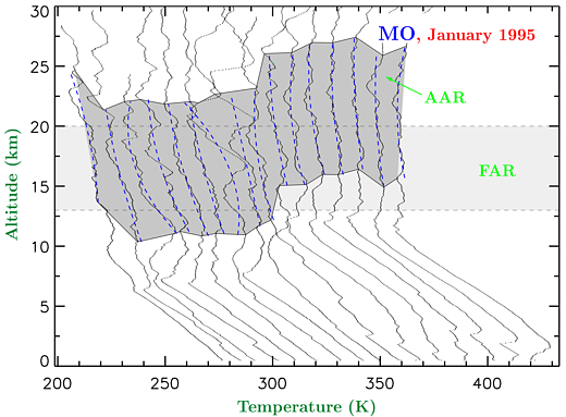
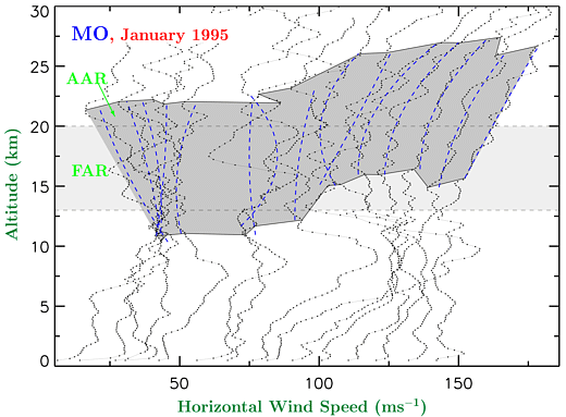
As an example, selected vertical profiles of temperature and horizontal
wind speed for MO, January 1995 are shown in Figure 1. For clearness
the curves are shifted from each other by 10 K and 10 ms -1 , respectively. An unperturbed background profile (T0 , u0, v0) is defined by fitting a quadratic polynomial to the measured
profile in the respective altitude range (blue dashed curves).
The local deviations (T', u', v' ) from this background state are considered as due to gravity
waves. For this approach see e.g. Allen and Vincent, 1995; Whiteway, 1999. For our analysis two altitude ranges are applied: a fixed
one as for the global climatology within SPARC (FAR = zT - zB , where zB= ZTP+ 2 km, zT = zB+ 7 km and ZTP = 11 km is the climatological zonally averaged tropopause height
(Hoinka, 1998) for the investigated geographical region). The new adaptive
altitude range is defined by AAR = zT - zB , where zB(t)=zTP(t) + 4 km, zT (t) = zB(t) + 11 km and zTP(t) is the time dependent tropopause height. The altitude ranges
FAR and AAR are indicated in the figure by bright and dark shadings,
respectively.
The lower edge of the AAR shows very clearly the strong variability of the tropopause height in just one month. The thermal definition of the tropopause (WMO, 1957) is used to obtain its height. Within our 10 year analysis we find tropopause heights ranging from 6 to 15 km, and a mean value of about 11 km which agrees very well with the zonally averaged value of Hoinka, 1998. Thus, if one uses the FAR, there are some profiles with the tropopause lying within the analyzed range. An inversion at the tropopause (which is typical for northern midlatitudes) would then be misinterpreted as part of a wave fluctuation. Eventually, this overestimates the contribution to the calculated energy density for the respective profile. In order to avoid misinterpretation due to tropopause effects we defined the above AAR, which represents a constant range in altitude referring to the temporal varying tropopause. To ensure that there will be really no effects from the tropopause, this altitude range starts 4 km above zTP(t).
Previous: Introduction Next: Analysis and Climatology Up: Abstract