 |
Stratospheric Processes And their Role in Climate
|
||||||||
| Home | Initiatives | Organisation | Publications | Meetings | Acronyms and Abbreviations | Useful Links |
![]()
|
Stratospheric Processes And their Role in Climate
|
||||||||
| Home | Initiatives | Organisation | Publications | Meetings | Acronyms and Abbreviations | Useful Links |
![]()
During the winter of 1999-2000, the NASA-sponsored SAGE III Ozone Loss and Validation Experiment (SOLVE) was jointly conducted with the European Commission-sponsored Third European Stratospheric Experiment on Ozone (THESEO 2000).
This SOLVE/THESEO-2000 mission was designed to both investigate the processes that control polar and mid-latitude winter and spring ozone levels, and to validate measurements from the Stratospheric Aerosol and Gas Experiment (SAGE) instrument. Unfortunately, SAGE III was not launched on schedule, but SOLVE/THESEO-2000 was able to take advantage of our other satellite assets to understand polar ozone losses from this last winter.
Since the discovery of the Antarctic ozone hole in 1985 by Farman et al. [1985], concern over the possible appearance of similar Arctic losses has led to a series of American and European field campaigns in the Arctic region. In fact, during the 1995-96 and 1996-97 winters, large losses were observed over the Arctic as a direct result of the cold and persistent stratospheric winter conditions. While measurement campaigns during the last decade have greatly increased our understanding of polar processes and the reasons behind these low ozone winters, a number of key questions remain unanswered and certain observed aspects of the polar stratospheric winter remain unresolved. The science goals of SOLVE/THESEO-2000 involved: 1) acquiring a complete body of information that would allow us to understand the detailed mechanisms that lead to these large ozone losses, 2) understanding the possible bearing of polar ozone on mid-latitude ozone decline, and 3) to sufficiently validate satellite instrument ozone observations used for long term trends in the polar regions.
The SOLVE/THESEO-2000 campaign combined aircraft, ground, balloon, satellite, and theoretical investigations for a comprehensive measurement campaign over the course of the 1999-2000 Arctic winter. Aircraft platforms included the NASA ER-2 high-altitude aircraft, the NASA DC-8 long-range aircraft, the DLR falcon, the French Mystère, the French ARAT, and the Swiss Learjet. Amongst the numerous balloon launches were two launches of the NASA OMS in situ payload, two launches of the NASA OMS remote payload, two launches of the PSC analysis payload, a launch of the TRIPLE payload, launches of the CNRS SAOZ package, 2 launches of the CNRS long duration balloons, launches of the HALOZ package, and numerous ozonesonde launches as part of the MATCH campaign. Additional ground based measurements were provided from instruments at Kiruna, Alomar, and Ny-Alesund.
SOLVE was staged from Kiruna, Sweden over three phases: 1) early winter (15 Nov. to 15 Dec.), 2) mid-winter (12 Jan. to 5 Feb.), and 3) late-winter (24 Feb. to 14 Mar.). The first phase was timed to see the early winter conditions both prior to and during the appearance of polar stratospheric clouds (PSCs). The second phase was timed to the peak period of PSC activity and chlorine activation. The third and final phase was timed to the period of large ozone loss. The aircraft were stationed at the Arena Arctica facility at the Kiruna airport, while the balloon launches were made from the balloon launch Facillity at Esrange, about 30km from Kiruna.
The 1999-2000 winter was quite cold, and the deployment timing worked perfectly. Figure 1 shows the total area covered by temperatures below 195K at 50hPa in the Arctic as derived from the NCEP/NCAR reanalysis data from 1958 to the present. The 1st row of diamonds at the top of the figure show the dates of DC-8 flights, and the 2nd row shows the dates of the ER-2 flights. The initial deployment of the DC-8 occurred during this period of first appearance of temperatures cold enough for PSC formation. The 2nd deployment included both the NASA ER-2, NASA DC-8, DLR Falcon, and French ARAT aircraft. Cold temperatures covered extensive regions over this period. In fact, the coverage nearly reached 15 million km2 on January 28, 2000, setting a record for the Arctic winter in this 42-year climatology. The third period covered the disappearance of cold temperatures as the vortex began it's break up. During this period, the vortex was again sampled by the NASA ER-2, NASA DC-8, and the Swiss Lear Jet. The areal coverage of cold temperatures was almost always greater than average for the winter with the exception of a few isolated days in December, a week long period in February, and a slightly below average period from mid-March.
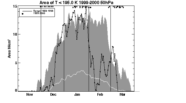
Figure 1. Areal coverage of temperatures below 195K in the Arctic during the 1999-2000 winter (connected dots). The grey shading shows the range of this areal coverage for all of the winters from 1958-59 to 1998-99, while the white line shows the average areal coverage from this 42-year climatology.
The cold temperatures observed during the December deployment are illustrated with data from the NASA/GSFC AROTEL Rayleigh lidar aboard the NASA DC-8 (Figure 2). This flight track was the return trip from Kiruna, Sweden to NASA Dryden on December 16, 1999. The flight passed over Northern Greenland, down across Central Canada, and directly to NASA Dryden in Southern California. As can be seen from the plot, temperatures were quite cold in the mid altitude region between 22 and 28km (30hPa is at about 24km).
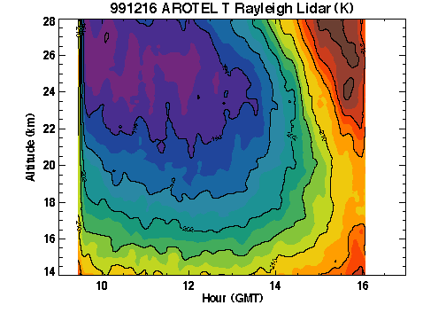
Figure 2. Temperatures observed by the joint NASA/GSFC and NASA/LRC Airborne Raman Ozone and Temperature Lidar (AROTEL) aboard the NASA DC-8 on the DC-8 flight of December 16, 1999 (PIs: Drs. John Burris, Thomas McGee, and Chris Hostetler).
The cold temperatures of the Arctic lower stratosphere during the 1999-2000 winter led to the formation of extensive layers of polar stratospheric clouds (PSCs). While PSCs were observed during the December period, extensive PSCs were encountered during the second deployment by the various platforms of SOLVE/THESEO-2000. The importance of PSCs to the chemistry of the stratosphere is that they convert the reservoir species HCL and ClONO2 into reactive forms of chlorine. The extensive coverage of PSCs fully processed the air inside the vortex by mid-December. Temperatures tended to remain cold throughout the winter and into mid-March. Figure 3 displays 1064nm backscatter data from the NASA Langley UV Differential Absorption Lidar (DIAL) system on January 20, 2000. In this figure, the PSCs are viewed as the higher backscatter ratios as green, yellow, and red colours. This flight was the first joint flight of the ER-2 and DC-8 during the SOLVE mission. The flight track ran from Kiruna, Sweden up to Spitzbergen, and then up to the North Pole, with a return along the same track. The maximum latitude of 89N is reached near 14:12 GMT. The flight track of the ER-2 above the DC-8 is superimposed as the black line. The lidar clearly shows the extensive PSC that the ER-2 sampled in situ over the course of this flight. These PSCs were both extensive and thick during this phase of SOLVE. Figure 4 shows one of these beautiful PSCs as photographed from the ground in Kiruna on January 27, 2000.
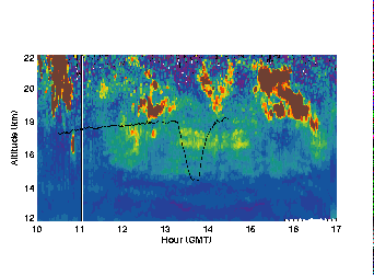
Figure 3. Aerosol backscatter (1064nm) as measured by the NASA Langley UV Differential Absorption Lidar (DIAL) system on January 20, 2000 (PI: Dr. Edward V. Browell). The farthest north position of the DC-8 (89.4N) was reached at 14.12, and the thin black line running across the page shows the ER-2 flight track above the DC-8. The two aircraft flight tracks were coincident to within 50km and 15 minutes. Backscatter ratio values greater than 0.8 are indicated by the deep red colour.
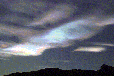
Figure 4. Polar Stratospheric Cloud photographed by Drs. Randy Kawa and Paul Newman on January 27, 2000 from the ground just outside the Arena Arctica hangar in Kiruna, Sweden.
The levels of ClO and Cl2O2 were also quite high during the campaign. The Harvard ClONO2 instrument makes in situ measurements of ClONO2, ClO, Cl2O2, and NO2. Figure 5 displays a trace of N2O measured by the NOAA/CMDL Airborne Chromatograph for Atmospheric Trace Species (ACATS IV, PI: Dr. James Elkins) as a function of latitude during a flight into Russia (just near St. Petersbourg, then down to about 50°N) on January 27, 2000. Inside the vortex are found very low N2O values, while outside the vortex, the N2O values are quite high. Hence, N2O provides a high resolution marker for the vortex position. Associated with the low inner vortex N2O are very high levels of ClOx as a result of conversion of HCl and ClONO2 into reactive forms on the surfaces of PSCs. Outside the vortex, levels of ClOx were quite low, while levels of HCl and ClONO2 were quite high. In addition to the scientific importance of this flight, this flight was a historic first flight of the ER-2 (the civilian version of the U-2) into Russian airspace since of Francis Gary Powers in the U-2 in May 1960. This flight would not have been possible without the close collaboration of our Russian colleagues in obtaining overflight clearance.
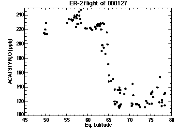
Figure 5. Measurements of N2O from the ACATS-IV gas chromatograph (PI: James Elkins) versus equivalent latitude for the ER-2 flight of January 27, 2000.
Because of the high amounts of ClOx in the Arctic, and because of the persistence of PSCs into March, there was large chemical ozone losses in the lower stratosphere. Using in situ ER-2 ozone observations constrained by measurements of long lived tracers, we estimate that the local loss at about 20km exceeded 60%. Local losses of this magnitude are in reasonable agreement with the Total Ozone Mapping Spectrometer (TOMS) observations from the Earth Probe Satellite. Figure 6 displays the March average of ozone in the polar region. March 2000 was an extremely low ozone winter, similar to the values observed during March 1997.
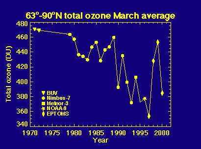
Figure 6. March average of Arctic total ozone from satellite observations. The various satellites are indicated on the figure legend. This figure is updated from Newman et al. [1997].
Activities generally came to a conclusion in mid-March with the departures of the ER-2 and DC-8. However, additional launches of ozonesondes, two SAOZ flights, and some flights of the French Mystère provided further information on the ozone losses that continued into late March, and the breakup of the polar vortex.
The SOLVE/THESEO-2000 missions have concluded their observational phases, but the analysis of the information will continue into the next few years. The first joint science team meeting will be held in Palermo, Italy on September 25-29, 2000. A special session will then be held at the American Geophysical Union's meeting in San Francisco on December 15-19, 2000.
Additional details on SOLVE and THESEO-2000 can be found via the World Wide Web at http://cloud1.arc.nasa.gov/solve/ and http://www.ozone-sec.ch.cam.ac.uk/, respectively.
![]()