 |
Stratospheric Processes And their Role in Climate
|
||||||||
| Home | Initiatives | Organisation | Publications | Meetings | Acronyms and Abbreviations | Useful Links |
![]()
|
Stratospheric Processes And their Role in Climate
|
||||||||
| Home | Initiatives | Organisation | Publications | Meetings | Acronyms and Abbreviations | Useful Links |
![]()
APE-THESEO, the contribution of the Airborne Platform for Earth observation to the Third European Stratospheric Experiment on Ozone (THESEO), was performed from the island of Mahè in the Seychelles (4¡S, 55¡ 30¡E) in February and March 1999. The mission was the primary tropical component of the European Commissionâs THESEO programme, which aims to understand the processes affecting stratospheric ozone, particularly its decline over the middle latitudes in the last two decades. APE-THESEO contributes to THESEO by studying the way in which the composition of air changes as it moves from troposphere to stratosphere.
Two aircraft were used in APE-THESEO: the M-55 Geophysica high-altitude research aircraft and the DLR Falcon, which is an executive jet converted to research use. The missionâs objectives and goals were to study the transport, chemistry, and cloud physics of the tropopause region (MacKenzie et al., 1999). An important secondary objective was to provide top-of-troposphere measurements for INDOEX, the Indian Ocean Experiment, which focused on the direct and indirect aerosol effects on climate. In this article we describe general aspects of the tropopause region during the mission.
Readers of the SPARC Newsletter do not need to be reminded of the general arguments for making measurements at the tropical tropopause: see, for instance, the articles by Kley and Russell (1999), and Reid (1998). The particular rationale for using aircraft in APE-THESEO was to study tropical processes with greater spatial resolution than possible from space, and with the ability to fly to areas of interest, which is not possible using balloons. Both of these considerations turned out to be important.
The payloads, described in more detail below, were selected to measure particles, long-lived trace gases, water vapour, ozone, and radiative fluxes. Particular care was taken to have redundancy in measurements of the key species, water vapour and ozone. We are now in the process of careful cross-validation and analysis of all the data, but some preliminary results are already becoming clear.
The instrument payload for the Geophysica is given in Table 1. The Falcon was equipped with the OLEX ozone-and-aerosol lidar system. Given the relative youth of most instruments, data capture was very good. Flying in the tropics is one of the most stringent tests of instrument reliability. Temperatures at the surface are above 30¡C, with humidities near 100% (~45mbar); whilst, at the tropopause, temperatures are less than -80¡C and water vapour pressures are extremely small (~10-4mbar). Several instruments experienced problems with frosting on optical parts, or other faults related to environmental stress, but only the two COPAS instruments, the newest instruments on board, gave no data.
Table 1: Instrument payload for the Geophysica during APE-THESEO.
| Acronym | Investigator | Description |
| ABLE | Fiocco | zenith/nadir millijoule lidar, 532nm |
| MAL | Mitev | zenith microjoule lidar, 532nm |
| MAS | Adriani | side-looking scatterometer, 532nm |
| CVI | Ström | counterflow impactor inlet and Lyman- aspectrometer for condensed water. |
| CVI-TDL | Mazzinghi | tunable diode laser for water and HNO3, with CVI inlet. |
| COPAS | Borrmann | condensation nuclei counter. One connected to the CVI inlet, one sampling ambient air. |
| FSSP | Borrmann | particle size-spectrometer. |
| SORAD | Khattatov | integrating pyranometer. |
| GASCOD | Giovanelli | DOAS and spectral radiometer. |
| FLASH | Yushkov | Lyman-a water vapour. |
| FISH | Schiller | Lyman-a water vapour. |
| ACH | Mezrin | frost-point hygrometer. |
| FOZAN | Yushkov Ravegnani |
solid-phase Chemiluminescence for ozone. |
| ECOC | Rudakov | electrochemical cell for ozone. |
| HAGAR | Volk | gas chromatograph for N2O, F12, F11, H-1211, and SF6 IR-Analyzer for CO2 |
The flights performed are shown in Figure 1. Six of the seven Geophysica flights were conducted in tandem with the Falcon. The real-time data display on board the Falcon enabled the Falcon to path-find for the Geophysica, as demonstrated first in APE-POLECAT (Stefanutti et al., 1999). A "Hauptexperimentator" for each sortie was chosen to travel on the Falcon. Armed with the latest Meteosat-5 images, forecast data from the UK Meteorological Office, and the real-time lidar display, the Hauptexperimentator passed instructions to the pilot of the Geophysica via the Falconâs pilots. Only with this level of support was the Geophysica pilot able to intercept the tenuous cloud features that are described below. Amongst the manoeuvres performed were quasi-Lagrangian flight-legs in sub-visible cirrus (cf. Peter et al., 1999). We believe that this is the first time that sub-visible cirrus has been sampled in this way. Quasi-Lagrangian flight-legs take instruments along a path similar to that followed by the cloud particles, and so provide observational data that is more readily comparable with model output. This airborne guidance operation also enabled the Geophysica to Îstepâ through shallow cloud features, taking horizontal measurements every 200 m in altitude, and enabled the Geophysica to fly safely into the centre of cyclone "Davina".
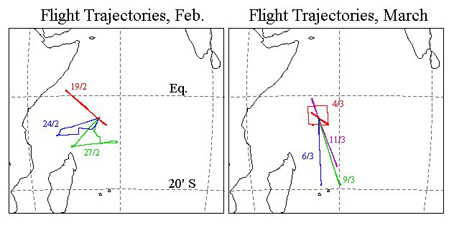
figure 1: flight paths of the geophysica during ape-theseo. falcon flight paths are very similar, but the geophysica flight of 4th March was flown alone.
The mean and extreme vertical profiles of temperature and saturated water vapour mixing ratio are shown in Figure 2. Minimum temperatures near -90¡C were measured, at heights around 18km. At these altitudes, air at such cold temperatures has a saturated water vapour mixing ratio of 1-2ppmv. The water vapour measurements made during APE-THESEO show that such dry air was indeed present (Figure 3). The likely sources of dry air at the tropical tropopause are: (i) slow upwelling that dries air through large-scale sub-visible cirrus formation (Newell and Gould-Stewart, 1981); (ii) convective overturning in cirrus anvils (Danielson, 1982); or (iii) drying by gravity-wave-induced cirrus clouds (Potter and Holton, 1995). Analysis of infrared Meteosat-5 images has established that local convection did not penetrate the tropopause where these low water vapour mixing ratios were measured, so the cause of the dryness must be sought elsewhere. One obvious possibility is recent drying in intense convection, or large-scale cirrus, upwind (i.e. east) of the measurements. We are studying radiosonde data from across the Indian Ocean, as well as trace gas measurements made on board Geophysica, to identify the source(s) of air to the tropopause region of the western Indian Ocean during this period.
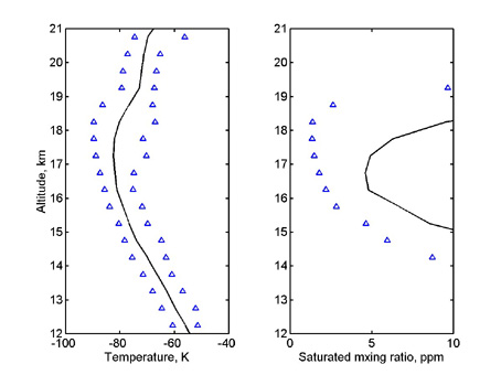
figure 2: mean and extreme vertical profiles of temperature, as measured by the geophysica during ape-theseo, and calculated mean and extreme saturated water vapour mixing ratios.

figure 3: water vapour measurements for 19 february 1999, from the flash instrument as a function of utc hour. the altitude and potential temperature of the geophysica are also shown. flash data from the first part of the flight are missing.
As explained above, installing the Hauptexperimentator on the Falcon provided the opportunity for very closely coordinated flights of the Falcon and Geophysica. In particular, the Geophysica was guided to the precise altitudes of extremely shallow layers of cirrus (Figure 4). The existence of the shallow layer shown in figure 4 is verified by independent measurements using the OLEX lidar. Using cloud-top brightness temperatures from Meteosat-5, which was re-positioned over the Indian Ocean as part of INDOEX, and which provided valuable half-hourly data to APE-THESEO, it is clear that convection in the region of the Seychelles reached only 16km or less for most of the mission. The cirrus observed at 17km and above cannot, therefore, be outflow from an existing convective system. It is possible that, like in the case of the cold, dry air, these cirrus layers are the remnants of vigorous convection upwind. On the flight to "Davina" on the 9 March 1999, data from the OLEX lidar shows one of these ultra-thin clouds apparently connected to a cirrus anvil. It is also possible that the cirrus is formed on the crests of gravity waves produced by local convection. There is evidence for gravity-wave-induced clouds from the Meteosat-5 images (Santacesaria et al., 1999), but these may not account for the thinnest clouds that were detected by the lidars. These ultra-thin clouds extend horizontally for hundreds of kilometres, but extend vertically only a few hundred metres. It seems unlikely that the atmosphere remains at saturation relative to water ice over these vast distances, and in the presence of intense, wave-inducing, tropical convection, so we speculate that the composition of these ultra-thin cloud layers is not pure water ice (Luo et al., 1999). From even these early stages of the analysis, it seems clear that the variety of tropical tropopause clouds is greater than hitherto assumed. The implications of this for water vapour transport, and for upper-troposphere-lower-stratosphere chemistry are intriguing (e.g. Borrmann et al., 1996).
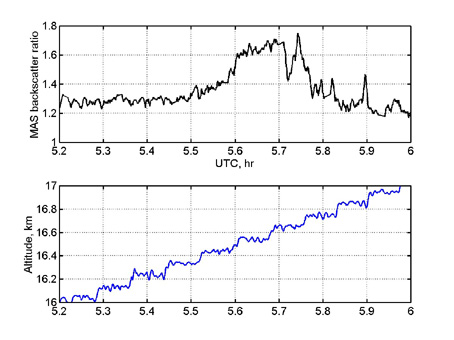
figure 4: mas backscatter data and geophysica altitude, for 27 february 1999. the figure demonstrates the geophysica being guided through a high-altitude cirrus layer in altitude steps of roughly 200m. the mas backscatter signal is yet to be finally calibrated. from satellite and visual observations, it is clear that no local convection reached 17km on this day.
On 9 March 1999, the Falcon and the Geophysica intercepted the ageing cyclone "Davina". Although ageing, Davina was still responsible for considerable damage and the closure of the airport when it struck Mauritius the next day. On the 9th, the Falcon penetrated deep into the cyclone. At one point the on-board radar and lidar recorded a concave wall of cloud in front of the aircraft, and a steep decrease in the altitude of the cirrus anvil above (Figure 5). From this point deep in the cyclone, the Falcon guided the Geophysica through the anvil. The Geophysica also performed a vertical profile at the point nearest the cyclone centre. Data from the in situ profiling shows a local ozone minimum at the tropopause, indicative of vigorous convection from a clean marine boundary layer. The implications of the radar, lidar, and in-situ measurements for anvil cloud formation and cyclone dynamics are being studied.
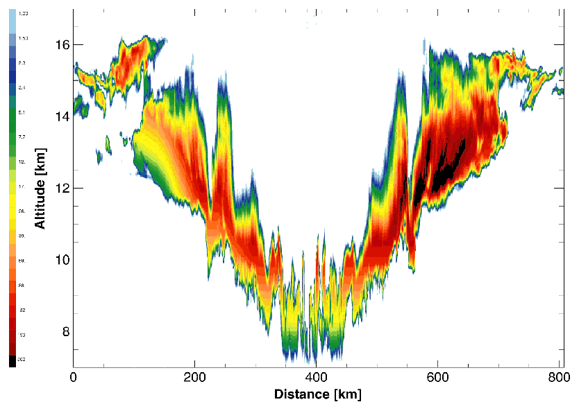
Figure 5. OLEX lidar data for the sortie on 9 March 1999, into the cyclone, "Davina". The base of the anvil cirrus descends from 14km to 7km over the 400km traverse of the system. When at the mid-point of the traverse (400km on the x-axis scale in the figure), the Falconâs radar recorded a concave wall of cumulonimbus around the aircraft, although no convection was encountered en route to the mid-point.
APE-THESEO is the second scientific mission, outside of Russia, of the Geophysica aircraft. We have again demonstrated the significant added value to be got from using a high-altitude platform, such as the Geophysica, with a pathfinder aircraft, such as the Falcon. A great deal of data has been collected: (i) on the structure of the tropical tropopause far from local sources of tropopause-breaking convection; (ii) and on the existence of ultra-thin cirrus clouds far above, or far from, cumulonimbus anvils.
In addition, we have made a number of meridional transects, including dives to 10km altitude, for the study of the distribution of trace gases. Radiative flux measurements were made on all flights, for comparison with INDOEX measurements. Vertical profiles in the stratosphere, from the lidars, scatterometers, and in situ instruments, confirm the very low background aerosol concentrations reported from APE-POLECAT (Borrmann et al., 1999) and elsewhere.
Although it is premature to draw any fixed conclusions from the mission, it seems certain that it will provide much needed clues to the behaviour of the tropical tropopause that will improve our analyses and forecasts of this climatically important region. More details of our preliminary results will be reported in the proceedings of the EC-sponsored Fifth European Workshop on Stratospheric Ozone, held in St. Jean de Luz in October 1999.
We gratefully acknowledge funding from the European Commission (ENV4-CT97-0533), the Italian Space Agency, and the European Science Foundation. This mission would have been impossible without the help of the Seychellesâ government, principally through Mr. Gilbert Faure, Director General of Civil Aviation of the Seychelles. We gratefully acknowledge that assistance. Support for meteorological forecasting came from the UK Meteorological Office, aided by a grant from the UK UTLS Ozone programme, from Eumetsat and the INDOEX Steering Committee, through their repositioning of the METEOSAT-5 satellite, and from the Seychelles Meteorological Bureau.
Borrmann, S., S. Solomon, J. E. Dye, and B. Luo, The potential of cirrus clouds for heterogeneous chlorine activation, Geophys. Res. Lett., 23, 2133-3136, 1996.
Borrmann, S., A. Thomas, V. Rudakov, V. Yushkov, B. Lepuchov, T. Deshler, N. Vinnichenko, V. Khattatov, and L. Stefanutti, Stratospheric aerosol measurements in the Arctic winter of 1996/1997 on the M-55 Geophysika, Tellus, submitted, 1999.
Danielson, E., A dehydration mechanism for the stratosphere, Geophys. Res. Lett., 9, 605-608, 1982.
Kley, D., and J. M. Russell III, Plan for the SPARC water vapour Assessment (WAVAS), SPARC Newsletter, 13, 5-8, 1999.
Luo, B.-P., et al., paper in preparation, 1999.
MacKenzie, A. R., K. S. Carslaw, Th. Peter, J. Str"m, and L. Stefanutti, Tropical convection and stratospheric chemistry ? the objectives of APE-THESEO, Mesoscale Processes in the Stratosphere, 153-158, Eur. Comm. Air Pollut. Res. Report 69, EUR18912 EN, Luxembourg, 1999.
Newell, R. E., and S. Gould-Stewart, A stratospheric fountain? J. Atmos. Sci., 38, 2789-2797, 1981.
Peter, Th., S. K. Meilinger, and K. S. Carslaw, Quasi-Lagrangian measurements of clouds at and above the tropopause, SPARC Newsletter, 12, 14-17, 1999.
Potter, B. E., and J. R. Holton, The role of monsoon convection in the dehydration of the lower tropical stratosphere, J. Atmos. Sci., 52, 1034-1050, 1995.
Reid, G. C., The tropical tropopause, SPARC Newsletter, 11, 16-19, 1998.
Santacesaria, V., et al., paper in preparation, 1999.
Stefanutti, L., A.R. MacKenzie, S. Balestri, V. Khattatov, G. Fiocco, E. Kyrö, and Th. Peter, APE-POLECAT ÷ Rationale, Road Map and Summary of Measurements, J. Geophys. Res., 104, 23941-23959, 1999.
![]()