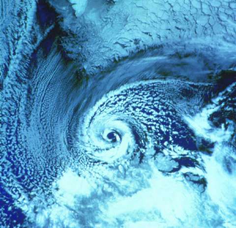
A polar low satellite image from NSIDC's Arctic Climatology and Meteorology PRIMER for Newcomers to the North.
Polar lows are mesoscale storm systems (500-1000 km) that form over oceans in polar regions. They form primarily in the winter months, and may have fairly high wind speeds associated with them. As a result, they can pose a significant threat to maritime activities in the area.These storms are of a research interest because of their combination of characteristics. They have a nature that is both convective, like hurricanes, and rotational, like other midlatitude storm systems. From an aesthetic point of view, I think that they're interesting because some of them look like little hurricanes, except they occur closer to the poles.
A major thrust of my research is to simulate specific historical cases of polar lows using a mesoscale atmospheric model. I use MM5 to do this. Most of the cases that I have simulated, and will simulate, have been imaged by RADARSAT-1. We use RADARSAT's images to find the lows because they are sometimes not well resolved by global models. In addition, because they occur over oceans in sparsely populated parts of the planet, it is very challenging to obtain very much observational data about these storms.
A Kelvin wave is a specific solution to the Shallow Water Equations that requires a lateral boundary to lean against. Wave velocity into and out of the side wall must be zero at the wall, and we make the further requirement that the wave velocity is zero everywhere. There is then a solution to the equations that allows for a wave that is trapped against the wall and whose envelope decays exponentially away from the wall. Rotation is required for this solution, and the wave propagates in such a way that in the northern hemisphere, the wall must be to the right of the wave as one looks in the direction of propagation.In the atmosphere, one might see these waves trapped against very high coastal topography. One might also require a well mixed layer of the atmosphere to be found below a capping inversion, where the air is basically unable to mix above because of a change in the stratification of the air. Then, if this inversion level is below the height of the coastal topography, one might see a Kelvin wave expressed along the inversion.