L.N.Yurganov, University of Toronto, Toronto, Canada
Note: NOAA/CMDL data, analysed here, has been FTP'ed from the CMDL/NOAA home page (see http://www.cmdl.noaa.gov/ccg ).
Carbon monoxide is usually referred to as a "quite variable trace gas". Generally it is true. CO mixing ratios in urban areas exceed those in rural regions 10-100 times due to a pollution. However, these polluted areas are not very vast, usually a few dozen and at most a few hundreds kilometres. They are expected to be missed by a space-borne instrument, like MOPITT. Moreover, the long-wave ("thermal") channel of the MOPITT is not very sensitive to the lower 1-2 km layer of the troposphere, where this man-made CO resides.
The second reason to call CO a variable component is a great difference in CO mixing ratio between hemispheres (2-3 times). It is really a global phenomenon, caused mainly by a disbalance in the anthropogenic emission between the hemispheres.
CO in the Northern Hemisphere undergoes distinct seasonal variations with a maximum in March-April and a minimum in late summer. An accumulation of man-made CO during the darker months and a rapid OH-consumption in April-May explains this cycle.
To estimate the horizontal distribution of CO mixing ratio in mid/high northern latitudes the data of the NOAA/CMDL flask ground-based network can be helpful (Novelli et al, 1991, 1992, Thoning et al., 1989, WEB page). The advantage of these data is the uniform analysis technique; moreover, it was compared to the German techniques (IFU-Garmisch and MPI- Mainz) and revealed an excellent agreement. Monthly mean mixing ratios and results of individual measurements (3-4 per week) are available in the Internet.
Monthly mean CO mixing ratios were calculated for each site by first averaging all mixing ratios in the complete site file having a unique sample time and date. These data were fitted with a curve, then values were pulled from the curve at weekly intervals, and these were averaged for each month to give the monthly mean mixing ratios provided in these files. Some sites were excluded from the monthly mean directory because of sparse data or a short record which did not allow a reasonable curve fit. Flagged data were not included in the analysis, and do not contribute to the monthly mean value. If there were 3 or more consecutive months without data, then these months were not included in the monthly file.
Four Arctic and six mid latitudinal sites are examined (see Table 1).
TABLE 1. SAMPLING SITES IN THE NOAA/CMDL COOPERATIVE AIR SAMPLING NETWORK (abbreviation, coordinates, altitude asl and starting date of sampling are presented)
Arctic sites.
*ALT Alert, N.W.T. 82 27'N 62 31'W 210m 04/92, Canada, Environment Canada/Atmospheric Environment Service
*BRW Barrow, Alaska 71 19'N 156 36'W 11m 07/88, U.S.A., NOAA/Environmental Research Laboratory (CMDL Observatory)
*MBC Mould Bay, N.W.T. 76 15'N 119 21'W 58m 02/92, Canada, Environment Canada/Atmospheric Environment Service
*ZEP Ny-Alesund, Svalbard 78 54'N 11 53'E 475m 02/94, Sweden/Norway, Zeppelin Station/Univ. of Stockholm
Mid latitude sites.
*CBA Cold Bay, Alaska 55 12'N 162 43'W 25m 04/92, U.S.A., NOAA/National Weather Service
*CMO Cape Meares, Oregon 45 29'N 123 58'W 30m 06/92, U.S.A, Oregon Graduate Institute of Science and Technology
*MHT Mace Head, County Galway 53 20'N 9 54'W 25m 06/91, Ireland, University College Atmospheric Research Station (AEROCE)
*NWR Niwot Ridge, Colorado 40 03'N 105 35'W 3475m 12/88, U.S.A., University of Colorado/INSTAAR
*SHM Shemya Island, Alaska 52 43'N 174 06'E 40m 06/92, U.S.A., DOD/U.S.A.F.
*UTA Wendover, Utah 39 54'N 113 43'W 1320m 05/93, U.S.A., NOAA/National Weather Service
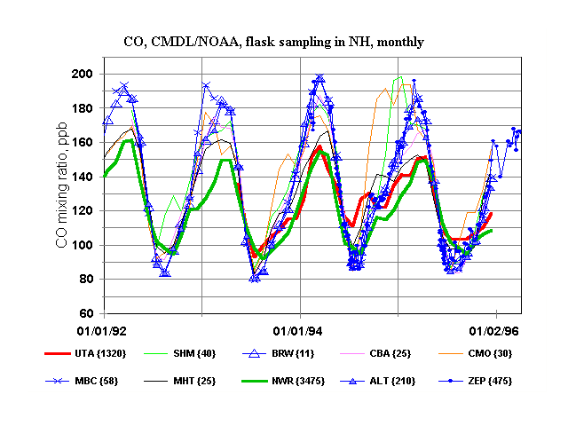
Monthly average CO mixing ratios, measured at 10 sites near the ground, are presented in Figure 1.
Figure 1. CO mixing ratios.Altitudes above sea level are given in brackets.
These stations differ both by their coordinates and altitudes above sea level. Four Arctic sites (all being well inside the BL) are plotted by blue. An agreement between the Arctic data is excellent. Two high altitude stations, Niwot Ridge, Colo.(NWR), and Wendover, Utah (UTA) are highlighted by thicker lines. The values for both sites are lower, than for the Arctic, near the CO maximum and higher near the CO seasonal minimum. The data for the remaining stations are in the range between the first two groups.
First of all, we should establish the year-round uniformity of CO mixing ratio in the lowest layer of the atmosphere throughout the Arctic. Long term averages differ less than 2% (Table 2).
TABLE 2. CO MIXING RATIOS IN PPB, AVERAGED OVER THE SAME PERIODS IN THE ARCTIC.
| Site | 04.1992 - 12.1995 | 02.1994 - 12.1995 |
| Mould Bay (MBC) | 133.46 | 133.97 |
| Barrow (BRW) | 133.11 | 135.56 |
| Alert(ALT) | 131.81 | 132.36 |
| Svalbard (ZEP) | -- | 132.96 |
Negligible local sources and/or effective horizontal mixing are the most evident explanations for that. However, small deviations from the perfect mixing was observed for some periods of time with a duration of several months. To make them clearer the Arctic average for each month was determined by simple averaging the data for four sites. Then deviations from these averages were calculated and plotted in Fig. 2 as a function of time.
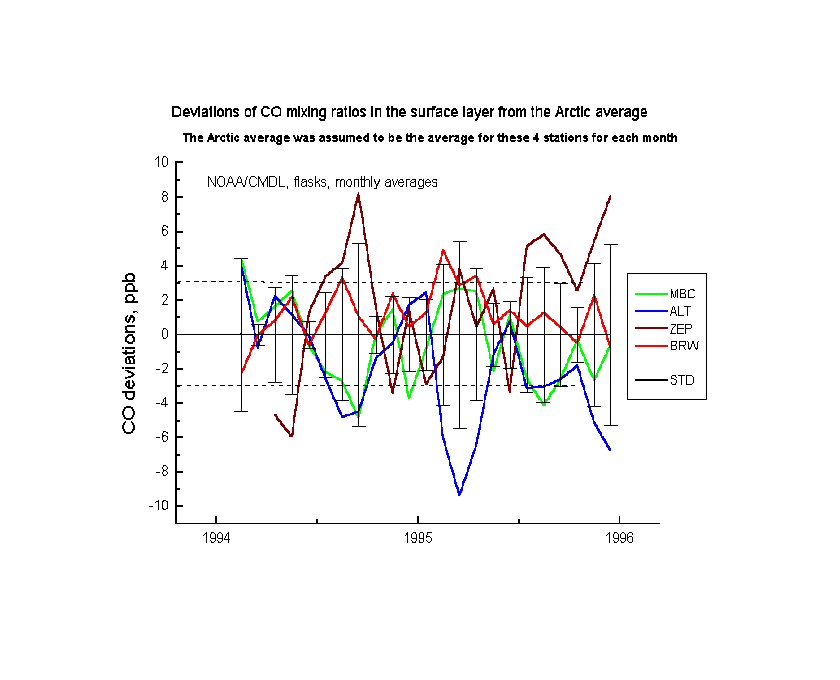
Figure 2. Deviations from the perfect mixing in the Arctic BL.
Standard deviations for these sites for different months are in the range 1 - 5 ppb, averaging near 3 ppb. In general, Barrow (red) and Mould Bay (green) data correlate well and do not deviate from the Arctic mean greatly. However, Svalbard (Spitsbergen) (brown) and Alert (blue) mixing ratios anticorrelate and differ sometimes from the Arctic average as much as ± 6-8 ppb. This is in agreement with a concept, that the polluted air enters the Arctic vortex through Svalbard and the "processed" (partially cleaned) air leaves the Arctic through Alert (Barrie, 1986).
Lower amplitude of CO mixing ratio in the free troposphere, than in the PBL (see NWR data in Fig. 1) is explained by diminishing vertical CO trend in early spring and constant CO or even its increase with altitude in summer. This was demonstrated by Yurganov (1997) and by Yurganov et al. (1997a) comparing tropospheric mean and surface mixing ratios in the Arctic.
A global distribution of CO, obtained from CMDL data, lead to a conclusion on an increase of surface CO mixing ratio from mid to high latitudes in winter-spring. This effect most probably is caused by comparing sites, located well outside the polar vortex (e.g., Shemya Isl. in Pacific or Mace Head, Ireland), to the Arctic sites. This "increase" reflects in fact just a higher CO mixing ratio in the Arctic BL (boundary layer), than in the marine BL over mid latitudes. At the same latitudes over continent CO should be much higher, than over oceans primarily due to a proximity to source areas. The "rag", reported by CMDL, therefore, should be longitudinally dependant greatly.
Recent publications by Yurganov (1997), Yurganov et al. (1997a) and Yurganov et al. (1997b) (the latter can be downloaded also in the PDF format) discuss these points in more detail. Here are just some results, not included in those papers.
It seems helpful to compare total column CO over Zvenigorod, Russia, measured by the solar IR spectroscopy and recalculated into weighted mean tropospheric CO, with CO mixing ratios at the height of 3475 m in Colorado, USA (Niwot Ridge), Fig. 3 and Fig.4.
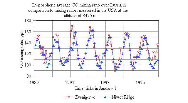
Figure 3. A comparison CO mixing ratios, measured by different trechniques in different sites.
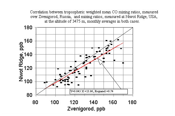
Figure 4. Correlation between CO data. Red line is linear regression.
One can see a good correlation between the two data sets, especially after January, 1991, when the calibration technique, used for flask analysis, was improved (see CMDL Web site). Mean mixing ratios for the entire period of concurrent measurements were 127.8 ppb in Zvenigorod and 121.8 ppb in Niwot Ridge. This appears to be an evidence of a good horizontal mixing for the troposphere as a whole (much better, than for the BL) in mid latitudes.
The correlation between these two data sets is valid apparently for an interannual variations. This allows to extend conclusions, made by Yurganov et al. (1997b) from the analysis of Zvenigorod data (e.g., on the influence of volcanic eruptions on CO concentration), onto the entire Northern hemisphere.
The another evidence for a validity of the interannual CO variations is presented by Yurganov and Notholt (1997). Episodic CO total column measurements in the Russian Arctic (between Severnaya Zemlya, 95 E, and Wrangel Isl., 178 W) as well as similar data, collected in Svalbard, 11 E, are plotted together with Zvenigorod data in Fig. 5.
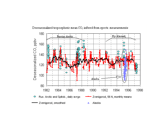
Figure 5. Spectroscopic data. Both Arctic and Zvenigorod data have been deseasonalized using the procedure, described by Yurganov et al. (1997b). Smoothing (black curve) was performed by running averaging with the step of 9 months.
One should keep in mind, that the Arctic data are more scattered, for they are daily means in contrast to monthly means, shown for Zvenigorod. However, important interannual CO deviations in Zvenigorod were reproduces in the Arctic data set too (decline in 1983-1985 and following relaxation, decline of 1992-1993 and a relaxation afterwards, a drop of 1997). Arctic CO abundances in 1982 and 1987-1988 were higher than in Zvenigorod, the influence of forest fires should be examined. A notably lower CO was measured over central Alaska in 1995, a proximity of the Pacific clean area may explain this depression.
How does the process of polluting the Northern Hemisphere by CO occur?
Winter-spring.
Normally during darker months of the year (and, inertially, right after the Sun's recovery) human emissions play the dominant role in the CO cycle in the NH. There are a few populated areas: the Eastern coast of the USA (see Allen et al., 1996, and references therein), Europe and the Western part of the former USSR and South-East Asia (Japan and China, in particular). Any of these regions impact adjacent "clean" areas as well as the NH as a whole. As to the Arctic, it is polluted mainly by Eurasia; these areas are well inside the boundary of the Arctic air mass in winter. Therefore, contaminated air parcels easily move into high latitudes and are mixed there (see corresponding section above). A contibution of the USA and South-East Asia in the Arctic pollution appears to be less. Cyclons (low pressure systems) play an important role in this process.
Some idea of the CO transport from Japan to the Nort-East can be found in the paper by Jaffe et al., 1997. A time series of CO and ozone measurements at Shemya Isl. (Aleutian Archipelago) in April-May, 1995 reveals periods of CO spikes (with magnitudes 12-20%), coincided with enhanced ozone (Fig. 6).
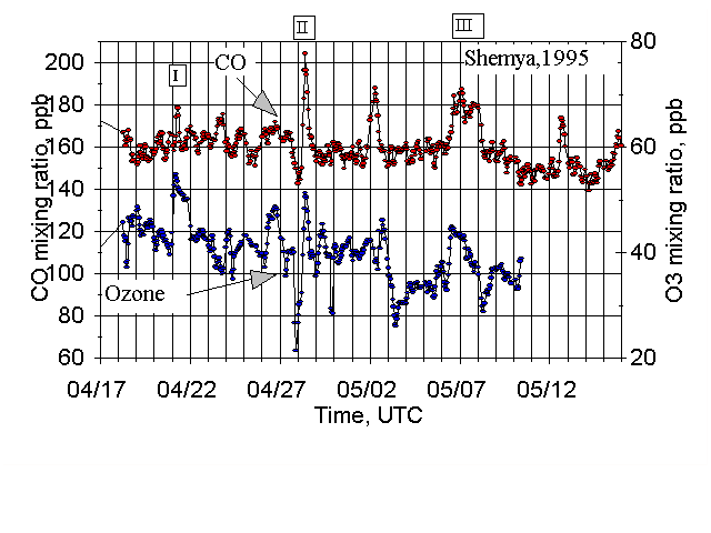
Figure 6. Measured in situ CO and O3 data (4-hour averages) from Shemya, April 17 to May 10, 1995. The numbers refer to different cyclonic systems which passed near Shemya during this period.
The tracks of cyclones during this period of the year exactly go from Japan to the Bering Straight via Shemya Isl. (see Fig.9 in Jaffe et al., 1997). Using the speed of these cyclones (30-50 km/h) and duration of pollution episodes (12-36 hours) we can estimate a horizontal size of these "patches of pollution": 600 - 1200 km. We have no information on a vertical extension of these polluted air parcels, however. It is a question also can these contaminated air parcels be detected by the thermal channel of the MOPITT.
Summer-autumn.
During the period of active photochemistry man-made pollution does not play a decisive role in CO levels on a global scale. In the Northern Pacific in July, 1994, for example, a transport of clean air from the Cental Pacific took place. The biomass burning becomes important globally as a source of CO in this period of the year. It was demonstrated clearly by CO measurements from space-borne MAPS instrument (Connors et al., 1996). The unexplained CO maximum in Shemya Isl. in early September, 1994, probably, reflected the beginning of the same process, detected by the MAPS one month later; namely, huge biomass burning in South-Eastern Asia. And again horizontal dimensions of these atmospheric patterns will be determined by synoptic processes. CO, produced by the biomass burning, should be transported via the middle troposphere and can be easily detected by the MOPITT.
Before starting validation campaigns we should examine what would be the most important results of MOPITT measurements; which features in CO space-time variability would be retrieved and discussed, and which peculiarities in the satellite data have to be confirmed by independent ground-based measurements.
The MOPITT's continuous picturing CO over the Canadian territory (as well as over the entire Globe) during the year would bring a wealth of information. First, a seasonal CO change can be revealed. If the CO profiling would be successful, an evolution of CO profiles over continents and Arctic Ocean will be determined. An idea of this evolution can be drawn from the report of Yurganov and Notholt (1997), Fig.7.
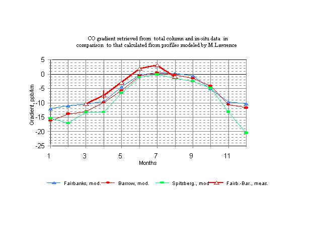
Figure 7. Seasonal variations of the shape of smoothed vertical CO distribution.
Actual profiles, which are of rather complicated shape, were assumed linearly decreasing with height. Their slopes (gradients) were estimated comparing measured total column CO amounts to surface mixing ratios (Yurganov et al., 1997a). Actually the resolution of MOPITT is 3 layers in the troposphere and the mean gradient for the troposphere can be derived from the satellite data. For a comparison mean slopes of modelled vertical distributions in the range of altitudes 0-10 km (personal communication of Mark Lawrence, MPI for Chemistry, Mainz, Germany) for 3 sites in the Arctic are plotted. According to both experiments and models CO mixing ratio in the Arctic between November and March decreases with height with gradients between -10 and -15 ppb/km. During March-May gradient decreases down to zero. In July CO mixing ratio in some days increases with height: gradients were positive (Yurganov et al., 1997a). This additional CO is supplied by forest fires. Modelled profile in summer are constant with height; probably Lowrence's models underestimate this source of CO and do not reproduce these polluted layers in the troposphere. These results, obtained in Alaska, may be considered valid for the Arctic, at least qualitatively.
References
Allen, D.J., P. Kasibhatla, A.M. Thompson, R.B. Rood, B.G. Doddridge, K.E. Pickering, R.D. Hudson, and S.-J. Lin (1996), "Transport-induced interannual variability of carbon monoxide using a chemistry and transport model," Journal of Geophysical Research, vol. 101, 28655-28669.
Barrie L., Arctic Air Pollution, B.Stonehouse, ed., Cambridge University Press, 1986, 328 pp.
Connors, V.S., Novelli, P.C., Reichle, H.G.,Jr. Space Shuttle Views Changing CO in Lower Atmosphere http://www.agu.org/eos_elec/95201e.html
Novelli, P.C., J.W. Elkins, and L.P. Steele, The development and evaluation of a gravimetric reference scale for measurements of atmospheric carbon monoxide, J. Geophys. Res., 96, 13,109-13,121, 1991.
Novelli, P.C., L.P. Steele, and P.P. Tans, Mixing ratios of carbon monoxide in the troposphere, J. Geophys. Res., 97, 20,731-20,750, 1992.
Thoning, K.W., P.P. Tans, and W.D. Komhyr, Atmospheric carbon dioxide at Mauna Loa Observatory, 2. Analysis of the NOAA/GMCC data 1974-1985, J. Geophys. Res., 94, 8549-8576, 1989.
Yurganov L.N., 1997, Seasonal cycles of carbon monoxide over the Arctic and Antarctic: total column versus surface data, Atmos. Res., 44, 223-230.
Yurganov L.N. and J.Notholt , 1997. Total column and in-situ observations in the Arctic. Collaborative Research Grant, NATO International Scientific Exchange Programme, Final report.