3.4 Non-seasonal Variations
In addition to the seasonal variations described in the previous section, which are driven by the seasonal variation in solar forcing, there are a number of variations at other time scales. We describe here interannual variations and intraseasonal variations. We also discuss the variability of water vapour on small temporal and spatial scales.
3.4.1 Interannual Variations
In most of the UT/LS, interannual variations in the stratosphere and upper troposphere are almost completely independent: the quasi-biennial oscillation (QBO) in the stratosphere and the ocean-atmosphere interaction known as El Niño-Southern Oscillation (ENSO) in the troposphere. Only at the tropical tropopause are both phenomena evident.
The Quasi-Biennial Oscillation
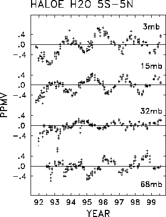
Among the most important transport-related influences on trace constituents in the stratosphere is the quasi-biennial oscillation. The quasi-biennial oscillation is an irregular fluctuation, with average period of 28 months, of the mean zonal wind in the equatorial lower stratosphere and is accompanied by temperature perturbations of a few degrees Kelvin. These perturbations represent a departure from radiative equilibrium and require a diabatic mean meridional circulation to maintain them. Positive vertical shear of westerly momentum (du/dz>0) is associated with above-normal temperatures and below-normal ascent, and vice versa. Through these anomalies in ascent, the quasi-biennial oscillation affects the distribution of trace constituents like water vapour. Because of its relatively long period, however, the quasi-biennial oscillation is difficult to identify in observations even with a record of several years. Two satellite data sets have sufficiently long records to isolate the signature of the quasi-biennial oscillation in stratospheric water vapour: SAGE II and HALOE. SAGE II water vapour data are significantly affected by aerosol contamination in the tropics at about 20 km (see section 1.4.3, and Figure 2.63), making isolation of a quasi-biennial oscillation signal problematic. Randel et al. [1998] have described the quasi-biennial oscillation signature using HALOE data and here we show the time series updated through 1999.
Figure 3.18 shows time series of HALOE water vapour anomalies over the equator, at several pressure levels spanning the lower to upper stratosphere. These time series are generated by simply removing the seasonal cycle at each level, following Randel et al. [1998]. The dominant component of interannual variability in the middle and upper stratosphere is a QBO signal, approximately out of phase between the 15 hPa and 3 hPa levels. There is an apparent QBO signal in the lower stratosphere, which appears most coherently after 1995, but relatively little QBO variance at 32 hPa. Figure 3.19 shows a vertical section of these equatorial water vapour anomalies, showing the vertical extent and coherence of the QBO variations. Similar variations occur in methane in the upper stratosphere (38-45 km), such that 2´ CH4+H2O is approximately constant there [Randel et al., 1998]. In contrast, the QBO patterns below 35 km in Figure 3.19 are not observed in methane (which in fact has a small vertical gradient there), and thus represent QBO modulations of water vapour due to other mechanisms.
Figure 3.18. Time series of zonal mean deseasonalised HALOE water vapour anomalies at 3, 15, 32 and 68 hPa over the equator, following the method of Randel et al. [1998].
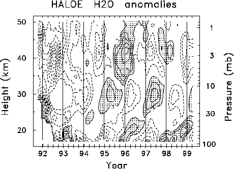
Figure 3.19. Time-height section of interannual water vapour anomalies over the equator. Contour interval of 0.1 ppmv, zero contour omitted. The anomalies are calculated by removing the annual cycle following the method of Randel et al. [1998].
Although the QBO is a tropical phenomenon, it affects trace constituents at mid-latitudes. Figure 3.20 shows meridional cross sections of HALOE water vapour measurements when the QBO was in roughly opposite phases: in April 1996 (top panel) and April 1997 (middle panel), and their difference (bottom panel). The extent of the QBO influence outside of the tropics is evident. A comparison of mean fields shows that the QBO induces large changes in meridional gradients in the subtropics [O'Sullivan and Dunkerton, 1997; Gray and Russell, 1999], and furthermore acts to modulate the double-peaked semi-annual oscillation patterns in the upper stratosphere [e.g., Kennaugh et al., 1997]. As was noted above, the large H2O anomalies in the upper stratosphere (and mid-latitude lower stratosphere) are mirrored in oppositely signed methane patterns, signifying that these anomalies are due to transport. The global character of the QBO meridional circulation patterns inferred from meteorological analyses are consistent with these mid-latitude patterns [Randel et al., 1999a].
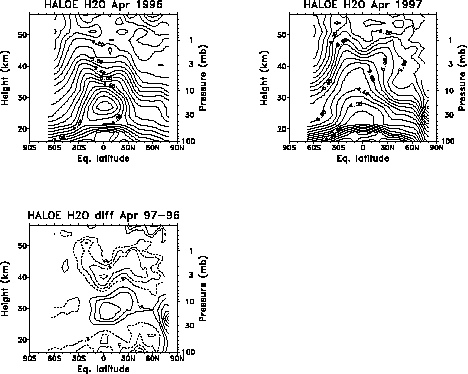
Figure 3.20. Zonal monthly mean equivalent latitude-height water vapour distribution for April 1996, April 1997 and the difference between them. The contour interval is 0.3 ppmv for the first two panels; in the third panel, the contour interval is 0.2 ppmv, the zero contour is omitted, and negative contours are dashed.
Several possible mechanisms are responsible for the water vapour variations in the lower stratosphere associated with the QBO. (1) The zonal mean circulation associated with the QBO, which is stronger in the winter hemisphere than in the summer hemisphere [Jones et al., 1998, Randel et al. 1999a, Kinnersley, 1999]. This mechanism affects water vapour throughout the stratosphere, particularly in the upper stratosphere, where advection from the summer hemisphere (see Figure 3.4) is significant. (2) The QBO influences planetary-wave propagation and the subtropical mixing barrier (see section 3.2) [O'Sullivan and Dunkerton, 1997; Gray and Russell, 1999; Gray, 2000]. (3) Interannual variations in equatorial ascent rate are associated with the QBO mean meridional circulation [Mote et al., 1996; Seol and Yamazaki, 1998; Randel et al, 1999a]. (4) The QBO affects tropopause temperature and pressure, hence the saturation mixing ratio of water vapour [Reid and Gage, 1985; Giorgetta and Bengtsson, 1999; Randel et al., 2000; Zhou et al., 2000a].
This last mechanism, which probably is the dominant mechanism represented in the tropical time series (Figure 3.19), bears further discussion. As was shown in Figure 3.11, annual variations in tropical tropopause temperature (section 3.3.3) are imprinted on air passing through the tropopause. In a similar manner, it seems plausible that interannual variations in tropical tropopause temperature induced by the QBO could modify the seasonal imprinting. The QBO's contribution to temperature variation near the tropopause is approximately ± 0.5 K, whereas the annual cycle in this region is about ± 5 K [e.g., Reed and Vlcek, 1969]. QBO circulation anomalies have associated temperature anomalies [Plumb and Bell, 1982]. Reid and Gage [1985] have shown that the QBO is associated with changes of ~300m in tropopause height, and potential temperature changes as expected from theory [Plumb and Bell, 1982]. These temperature changes can result in significant modifications to the saturation vapour mixing ratio, potentially changing the water vapour concentration of air entering the stratosphere. This effect has recently been simulated in a tropospheric GCM with an assimilated QBO [Giorgetta and Bengtsson, 1999]; the simulated water vapour anomalies in the lower and middle stratosphere are ± 0.2 ppmv, somewhat smaller than those shown in Figure 3.19.
El Niño and the Southern Oscillation
The leading pattern of global interannual atmospheric variability in the troposphere [e.g., Rasmussen and Wallace, 1983] is associated with El Niño and the Southern Oscillation (ENSO), an irregular variation of the tropical Pacific Ocean and overlying atmosphere with a return period of 2-7 years. In the cool or La Niña phase of the Southern Oscillation, the warmest water and convection are located in the western Pacific north of Australia. In the warm or El Niño phase, warm water and convection spread eastward, usually over a greater longitudinal range. Upper tropospheric water vapour is profoundly influenced by the Southern Oscillation, and not just in the tropics. In fact, the leading pattern of interannual variability in upper tropospheric water vapour (derived using empirical orthogonal function analysis; see Preisendorfer, [1998]) is also associated with the Southern Oscillation (Figure 3.21). This pattern highlights the tendency for the central and eastern Pacific to vary oppositely from the western Pacific and also has a strong signature in the subtropical Pacific, probably because strong convection in the central and eastern Pacific drives subsidence in the subtropics at those longitudes.
That this mode is associated with the Southern Oscillation is also clear from its temporal characteristics (Figure 3.21, lower panel). The strength and phase of the Southern Oscillation are often measured in terms of the average sea surface temperature anomaly over one of several rectangles in the Pacific Ocean [Trenberth, 1997], one of which is called Niño3 (5° N-5° S, 90° -150° W). The time series of the first principal component tracks that of Niño3 strikingly well. The large El Niño events of 1982-1983 and 1997-1998, and the La Niña event of 1998-1999, are clearly visible in both time series. Similar relationships with the Southern Oscillation are evident in the shorter MLS data set [Newell et al., 1997]. Wang and Fu [2000] describe the impacts of the Southern Oscillation on lower tropospheric water vapour. The mechanisms influencing upper tropospheric water vapour on the time scales of the Southern Oscillation are discussed above in section 3.3.2.
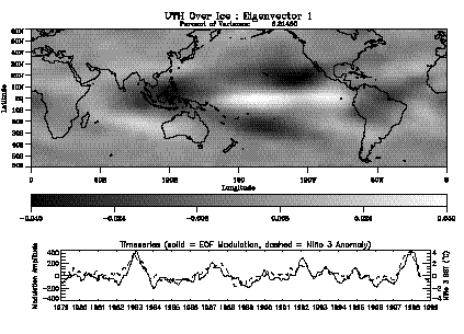
Figure 3.21. Leading global pattern of interannual variations in Upper Tropospheric Humidity over ice (UTHi), 1979-1999, from the HIRS data set (Section 1.4.1). Top panel, the pattern itself; bottom panel, its temporal evolution (solid line, left scale) compared with a normalised time series of average sea surface temperature over the domain 5° N-5° S, 90° W-150° W (dashed line, right scale).
3.4.2 Intraseasonal Variations
In the tropics, where the seasonal cycle in upper tropospheric water vapour is relatively weak [Newell et al., 1997], intraseasonal variations (those with periods of say 10-120 days) have a significant influence on upper tropospheric water vapour. Such variations are associated with the tropical intraseasonal oscillation or Madden-Julian Oscillation (MJO). The MJO is a tropical phenomenon with characteristic period of 30-60 days that has a signature in many tropospheric fields [Madden and Julian, 1971]. Only recently have satellite data been used to show the signature of the MJO in upper tropospheric [Clark et al., 1998] and lower stratospheric [Mote et al., 2000] water vapour. In upper tropospheric water vapour data from MLS, the MJO intraseasonal variability accounts for as much as 35% of total power (with daily time resolution), compared with 19% for the annual cycle [Clark et al., 1998].
Intraseasonal variations are evident in Figure 3.22, which is a longitude-time diagram of tropical water vapour produced with data from the HIRS instrument. Several slow, eastward-moving features appear over the Indian Ocean (45° -90° E) and travel to the middle of the Pacific before disappearing. For example, one feature can be tracked from 45° E in mid-November to about 180° E in early January, and another can be tracked from 0° E in early January to about 160° E in early March. These features tend to disappear in the central and eastern Pacific because the convection that generates them fades over the colder water there. The extension of warm water eastward along the equator during El Niño years (see section 3.4.1) allows convection and the associated MJO anomalies to penetrate farther eastward; this can be seen as the 1997-1998 El Niño event develops (top part of Figure 3.22) and was also shown using MLS data by Clark et al. [1998].

Figure 3.22. Intraseasonal variations in HIRS humidity for five-day average values over the domain 10° N-10° S. Contour interval is 7%, grey shading indicates positive anomalies, and dotted contours indicate negative anomalies.
The influence of the MJO on water vapour appears to extend at least to 100 hPa [Mote et al., 1998a, 2000] with an amplitude of only a few tenths of 1 ppmv (less than 10% variability about the mean), though the true variations may be much larger and could be smeared by the coarse vertical resolution of MLS [Mote et al., 2000]. Variations at the next MLS level up, 68 hPa, also have some spectral power in the intraseasonal band [Mote et al., 1998a], but it has not been shown that those variations are caused by the MJO. The mechanisms influencing upper tropospheric water vapour on these time scales are essentially the same as those for the seasonal cycle, which is discussed above in section 3.3.2.
3.4.3 Transient Variability
Though the focus of this document is on variability at large scales, when trying to assess large-scale variability from limited data it is important to recognise that spatial distributions of atmospheric constituents are far from being smooth. This point is especially relevant for water vapour in the upper troposphere and lower stratosphere since many of the most reliable data sources are point measurements with very limited spatial coverage. The existence of transient small-scale variations also complicates efforts to validate satellite observations against in situ data as discussed in Chapter 2.
Processes producing transient variations, and observed examples
A good overview of the structure present in the water vapour field is provided by geostationary water-vapour imagery (Figure 3.23), indicating significant horizontal structure in upper tropospheric relative humidity. Several processes account for this variability.
First, small-scale tracer structure results naturally from the process whereby air masses having different initial tracer concentrations are combined by fluid motions. Shear in the motion field tends to produce elongated structures which become increasingly sharp and fine-grained as the material surfaces are stretched and folded [Batchelor, 1952, Welander, 1955], before the tracer is eventually homogenised by molecular diffusion. Both chaotic advection (or stirring) and diffusion are essential for final tracer mixing to occur in a reasonable time [Young et al., 1982]. Even a simple, laminar motion field can create complex tracer structure, provided that the field is time varying [Aref, 1984]. Such mixing between moist and dehydrated air masses, performed by large-scale motions, accounts for many of the structures seen at mid-latitudes in Figure 3.23. This process tends to occur on isentropic surfaces [Pierrehumbert, 1991], and was simulated in the upper troposphere by Yang and Pierrehumbert [1994] and in the stratosphere by Pierce and Fairlie [1993] and others. The process is widely believed to lead to fractal tracer distributions (see below).
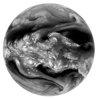
Figure 3.23. Image from GMS IR3 water vapour channel on 5 February 2000. This instrument observes upper tropospheric water vapour with a weighting function similar to HIRS.
Three-dimensional advective effects also add to small-scale structure. Non-turbulent "differential" advection can produce lamination in the vertical by bringing air masses of different origins into the same column at different levels [e.g., Newman and Schoeberl, 1995], a process that contributes to vertical tracer mixing [Haynes, 1997]. Turbulent events such as wave breaking can produce complicated laminar, roll-like, and/or filamentary structures [e.g., Bithell et al., 1994]. Such features have been reported most extensively in ozone [e.g., Reid and Vaughan, 1991; Appenzeller and Davies, 1992; Appenzeller et al., 1996], but also appear in water vapour [Gray et al., 1994] as would be expected. Horizontal moisture layering is also frequent in the troposphere [e.g., Mapes and Zuidema, 1996, Newell et al., 1999].
Vertical advection or convection can also produce horizontal structure in water vapour due to the extreme vertical gradients in the climatological water vapour field, particularly in the troposphere. Vertical transport can occur in association with waves at all scales, from small-scale gravity waves to large-scale wave-like phenomena such as the Madden-Julian oscillation (see also Section 3.4.2). The patterns most evident in the tropics in Figure 3.23 are clearly due to the contrast between near-saturated conditions in the immediate environment of convection and relatively dry surrounding areas. This variability occurs on length scales down to less than 1 km, and is transient in that convection decays and reappears on time scales of less than a day. Of course, variability in the tropics can also be produced by the advective mechanisms described earlier.
The importance of these processes in the troposphere is revealed by a series of profiles taken near Panama (Figure 3.24). Water vapour is again quite variable near and below the tropopause owing to tropospheric weather. In contrast, above the tropopause the vapour levels are low and change little from sounding to sounding. The relatively uniform dryness near the equator at the time of these measurements is also supported by ER-2 observations over the Pacific [Weinstock et al., 1995]. Similar conclusions may be drawn from the data presented in Kelly et al. [1993], though in that study somewhat more variability was found in the first few kilometres above the tropopause. Mechanisms leading to variability near the tropical tropopause are still poorly understood (see Section 3.3.3).
Recently, airborne laser hygrometers have begun providing unparalleled section views of the water vapour field that can help illustrate some of the structure that occurs and should lead to further understanding. A mid-latitude example measured by the NASA Lidar Atmospheric Sensing Experiment (LASE) off the East coast of the United States during July 1996 appears in Figure 3.25. Considerable horizontal variability is evident, with mixing ratios at 9 km varying by more than one order of magnitude owing to an intrusion of dry lower stratospheric air in apparent folding events near 69° W and 72° W longitude. Around 74° W, high humidity occurs in association with some clouds (not shown) that indicate prior convection. Small-scale vapour variations all along the flight (particularly evident between 4 and 8 km but noticeable at most altitudes) are likely remnants of earlier mixing events or filamentation, while slower horizontal variations near the tropopause (12-13 km level) shown here are probably related to large-scale vertical advection.
Since molecular diffusion is very slow in eliminating tracer gradients, the latter can become extremely sharp in the atmosphere, regardless of the advective or other mechanisms that create them. An example of this for water vapour near the tropopause is shown in Figure 3.26. Such features are highly problematic for accurate measurement of spatial averages or large-scale variations.
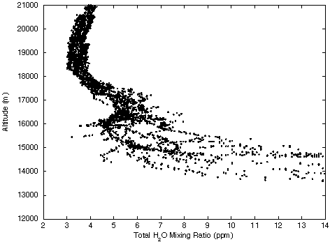
Figure 3.24. Total water vapour mixing ratio profiles obtained by the NOAA Aeronomy Lab. U2 Lyman-a hygrometer in September 1980 during the Water Vapour Exchange Experiment over Howard AFB, Panama. The profiles are from ER2 research aircraft on August 30 and September 7, 9, 11, 12, 13, 15, and 16. Previously published by Kley et al. [1982].
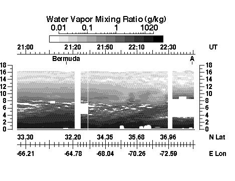
Figure 3.25. Measurements of water vapour mixing ratio during a flight near Bermuda and from Bermuda to Wallops, Virginia, on July 26, 1996 made by the Lidar Atmospheric Sensing Experiment (LASE) as part of the TARFOX campaign. Data provided by Syed Ismail and Edward Browell, NASA Langley Research Center.
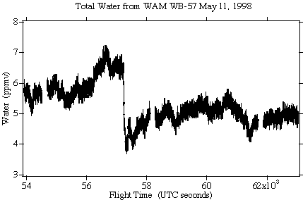
Figure 3.26. Total water observed on 11 May 1998 by the WB57F on a southbound leg from (30°N, 95°W) to (10°N, 95°W) at 120 hPa pressure. 103 seconds correspond to 200 km (figure provided by A. Tuck).
Statistical description of variability
Strategies for quantifying overall transient variability are not straightforward, and a number of statistical approaches to the modelling of tracer variability have been attempted. We do not attempt to review this active research area here, mentioning only a few recent studies specifically of water vapour in the upper troposphere and lower stratosphere. Gierens et al. [1997], analysing data from the MOZAIC program, confirmed that fluctuations of humidity and temperature from their local means are characterised by occasional large fluctuations (i.e. heavy-tailed distributions) in the upper troposphere. Gierens et al. [1999] found further that the frequency of occurrence of relative humidity greater than 100% decreased exponentially above ice saturation, and that it decreased exponentially for the entire range of values in the lower stratosphere. They offered a stochastic source-sink model capable of producing such distributions. Cho et al. [2000] analysed the scaling properties of the water vapour distribution in the troposphere, finding "anomalous scaling" or multifractality out to scales of 100 km. Similar behaviour was found for other tracers out to larger scales in the upper troposphere and lower stratosphere by Tuck and Hovde [1999]. Importantly, Cho et al. [2000] note that while vapour increments are statistically stationary (see below), the transient vapour field itself is not. This means that the probability distribution (e.g., variance) of transients cannot be characterised accurately from a finite number of observations. Work continues actively in this area.
To supplement these studies we present here a simple analysis focusing on the practical issue of comparing measurements from imperfectly collocated instruments. Specifically, we consider the increment distribution, or probability distribution of possible difference values dq between water vapour observed at two locations with a given horizontal separation distance dx, and at approximately the same time and height in the atmosphere. This and related measures of variability are discussed by Bacmeister et al. [1997] and Cho et al. [2000]. Since the variability is produced for the most part by free turbulent motions, it is also possible to convert statistical functions of separation distance at a given time into functions of time lag at a given location using Taylor's Hypothesis–i.e., by multiplying the time lag by a typical horizontal wind speed.
MOZAIC data serve this purpose well in the upper troposphere. Figure 3.27 shows the distribution of the variable dRH, the difference in moisture between two points 100 km apart. This distribution also is clearly non-Gaussian with a narrow peak near zero and very heavy tails (in fact it is reasonably well fit by decaying exponentials on either side of zero). The heavy tails reflect the existence of large jumps in humidity such as those discussed previously. Since these data are not collected strictly on an isentropic surface, they will contain some variability due to vertical structure in the atmosphere, if this is present, as well as horizontal.
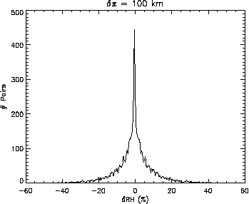
Figure 3.27. Histogram of dRH, the difference in relative humidity at two neighbouring locations in the upper troposphere separated by 100 km. Data are obtained from MOZAIC aircraft measurements at altitudes between 10-12 km. The histogram is symmetric because each pair is counted as a positive and negative difference.
Scaling behaviour [Cho et al., 2000; Tuck and Hovde, 1999] suggests that the properties of this distribution should change in a simple and predictable way with increasing separation distance dx. Distributions for other values of dx (not shown) are indeed qualitatively similar to that shown in Figure 3.27, but become broader with increasing separation distance.
This broadening is shown in Figure 3.28 as a second-order "structure function," or plot of the root-mean-square (RMS) value of dRH as a function of dx. The RMS difference increases from about 5% relative humidity at a few tens of kilometres, to 25% RH at distances of 1000 km or more. This increase appears roughly log-linear (a hallmark of "scaling" behaviour) until the statistics deteriorate at larger scales. The variability is somewhat greater in the tropics than in the northern mid-latitudes, out to distances of 100 km or less; this is likely due to the more frontal character, and/or greater horizontal shearing, of mid-latitude weather compared with that in the tropics. The difference is particularly apparent in the probability of two adjacent RH values differing by more than 10% (a nominal, modest accuracy level); at distances near 100 km the probability of this is almost twice as high in the tropics as at mid latitudes. Such statistical "heterogeneity" makes any statistical treatment of transient variability more difficult (see also Gierens et al., [1999]).
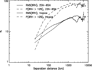
Figure 3.28. Plot of the square root of dRH2 as a function of dx, where dRH is the difference in relative humidity at two neighbouring locations in the upper troposphere separated by distance dx (solid lines); and probability that dRH will exceed 10% (dashed lines). Thick lines are for data north of 25N; thin lines, data between 25S and 25N. Statistical robustness weakens after a few hundred kilometres, where the curves become irregular, since effective sample size varies inversely with separation distance.
Figure 3.29 shows the structure function dq describing vapour variability in the mid-latitude lower stratosphere, as calculated from ER-2 measurements. Flights during the spring and fall seasons show more small-scale variability than flights during summer and winter. The high variability in spring is due to the early spring break-up and equatorward mixing of the relatively dry polar vortex, while that in fall is likely due to the delayed mixing of moist season (July-August) air from near the tropical tropopause [e.g., Rosenlof et al., 1997]. At other times, mixing is relatively inhibited. Significant jumps in mixing ratio (0.5 ppmv) are possible over distances as short as 10 km, especially in spring and fall, though the ratio of RMS variability to the mean (4-5 ppmv) is substantially less than that in the upper troposphere (Figure 3.28).
Instrument collocation
Plots such as Figure 3.28 and Figure 3.29 may form the basis for a quantitative approach to maximising the effectiveness of instrument intercomparisons. However, to go any further depends on the details of the task at hand, including the sampling characteristics of the instruments and the availability of approximate collocations. The issue of how to model tracer distribution statistics and use these to improve collocation efforts is an ongoing area of research with few results to date. Further quantitative development of this topic would be of great help to instrument validation and data assimilation.
A few things can be said on the basis of the foregoing plots and discussion, however. Large moisture differences are possible over small distances (illustrated in Figures 3.25 and 3.26), so that a reasonable number of instrument collocations is essential to say anything useful about the relative accuracy of any two instruments even when collocation is good. Figures 3.28 and 3.29 can be used as a rough guide to how much of the apparent discrepancy between two instruments can likely be explained by real variability in the moisture field, for a given set of collocation distances. Often, the comparison will be between an instrument with volumetric sampling (i.e. a satellite) and one with point sampling. In this case a rough idea of the possible natural variations can still be obtained from the given plots, though other statistics (less readily available from aircraft data alone) would be more appropriate. Gierens et al. [1997] give further analyses of direct relevance to collocation. Finally, these results also show that some seasons with less variability are considerably more favourable that others for instrument collocation.
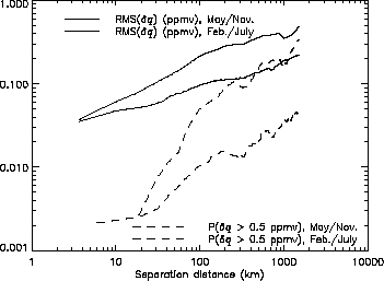
Figure 3.29. Plot of the square root of dq2 as a function of dx, where dq is the difference in mixing ratio at two neighbouring locations in the lower stratosphere separated by distance dx (solid lines); probability that difference will exceed 0.5 ppmv (dashed lines). Thick lines are made using flights during May and November; thin lines, flights during February and July. Data are obtained from Harvard Lyman-A measurements during the STRAT experiment, between latitudes of 25-55°N and potential temperatures of 460-500 K. A small correction has been applied to remove white instrument noise.