3.3 Seasonal Cycle
The seasonal cycle is the largest source of variability for water vapour in the lower stratosphere and upper troposphere. The seasonal cycle in water vapour is well characterised by numerous in situ and remote observational data sets collected during the last decade, as discussed in Chapter 2, and here we use a number of these data sets to characterise the observed seasonal variability. Because of the physical differences between regions, we separate the observations and processes in the lower stratosphere (3.3.1), upper troposphere (3.3.2) and the region around the tropical tropopause (3.3.3).
Throughout these three regions, the processes mentioned in section 3.2 contribute to varying degrees to produce the seasonal cycle in water vapour, with different factors dominating in different locations. In most of the stratosphere above about 20 km, the circulation dominates the seasonal cycle. In the southern polar lower stratosphere, a very low minimum occurs during winter because of dehydration. In the mid-latitude lower stratosphere below about 20 km, the maximum occurs in summer largely because of exchange with the moist upper troposphere. In the upper troposphere, the seasonal variation in the distribution of water vapour is dominated by the seasonal migration of the Hadley-Walker circulation cells. Relative humidity in the upper troposphere in middle latitudes is generally lower in summer than in winter, owing to the strong annual cycle of temperature there. In the tropical tropopause region, a complex mix of large-scale circulation, local dehydration, and radiative and convective processes combine to produce a seasonal cycle (with a minimum in roughly February) whose signature remains detectable for a year and a half as air rises slowly through the tropical stratosphere.
3.3.1 Lower Stratosphere
Overview
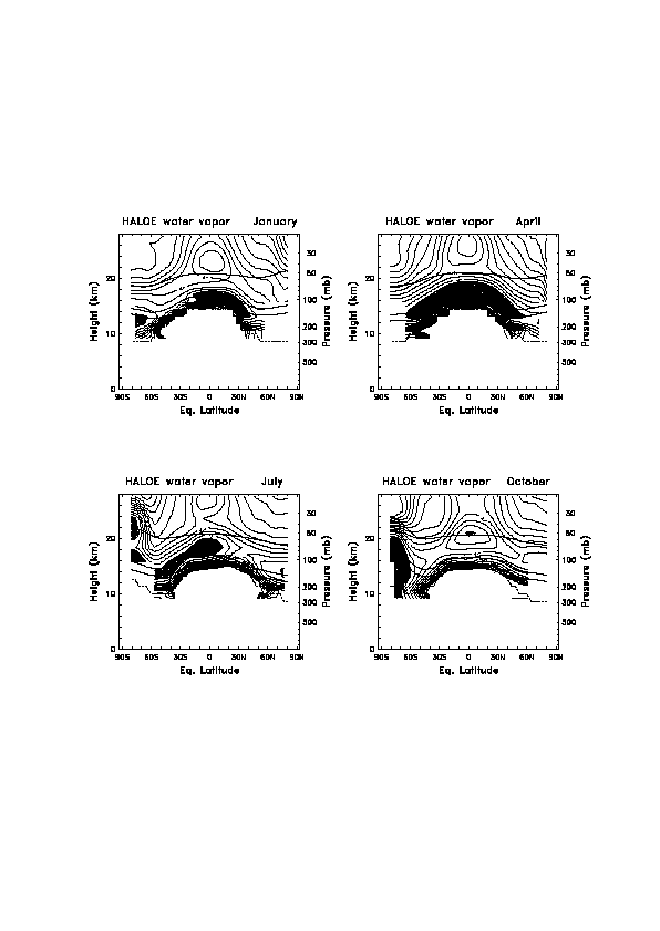
The seasonal cycle of water vapour between the tropopause and ~28 km altitude is shown in Figure 3.6, derived from HALOE data during 1991-99. The seasonal cycle is derived from a harmonic fit of the data set formed by combining HALOE and MLS data as described in section 3.2. It is important to note that the effective vertical resolution of HALOE is ~2 km, and this vertical smearing results in an underestimate of seasonal extremes in the lower stratosphere [Mote et al., 1996, Andrews et al., 1999]. HALOE observations near the tropopause are at the lower limit of the instrument’s useful range, and individual profiles may have large errors as discussed in section 1.4.5. The monthly means in Figure 3.6 present a qualitative picture near the tropopause.
Perhaps the most striking features of the seasonal cycle shown in Figure 3.6 are the variations in the tropical minimum and the seasonal dehydration in the southern polar vortex, both highlighted by the shading of low values. The low mixing ratios that form near the tropical tropopause in January spread poleward to cover much of the lower stratosphere between 60ûN and 60ûS by April, approximately following the sloping isentropes near the ~380-400 K levels, and is evidence for relatively fast isentropic mixing between tropics and mid-latitudes.
Figure 3.6. Meridional cross-sections of water vapour mixing ratio between the tropopause and ~28 km derived from HALOE measurements. Plots are shown for January, April, July and October, illustrating the seasonal cycle. For each month the dashed lines represent the tropopause, and the solid lines show the 380 K, 400 K, and 500 K isentropes.
The seasonal variation of water vapour in the lowermost stratosphere is further illustrated in Figure 3.7, showing the latitude-time evolution of HALOE data on the 380 K isentrope (~15 km); similar details in meridional structure are shown by Rosenlof et al. [1997] and Jackson et al. [1998]. These HALOE data suggest an absolute minimum centred slightly north of the equator during January-March, with the driest air then propagating both poleward and into the Southern Hemisphere. Relatively high water vapour values are observed during Northern Hemisphere summer centred near 30ûN, coincident with the convective phases of the Asian and North American summer monsoons. The high water vapour air also appears to propagate poleward and into the Southern Hemisphere, in a similar manner to that of the low values 6 months earlier. The result of the asymmetric maxima in Figure 3.7 is that the annual cycle is substantially larger in the Northern Hemisphere than in the Southern Hemisphere, and also that the Northern Hemisphere is wetter than the Southern Hemisphere on a time mean basis [see Rosenlof et al., 1997]. As discussed in chapters 1 and 2 measurements at low altitudes are difficult to make, especially in the presence of cirrus clouds, which may bias the results towards dry values.
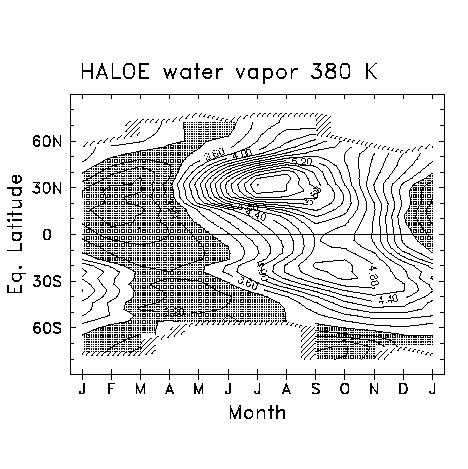
Figure 3.7. Latitude-time evolution of water vapour mixing ratio near 380 K derived from seasonal cycle fits of the HALOE data.
Polar lower stratosphere
Low values of water vapour in Southern Hemisphere polar regions during winter-spring, associated with dehydration in the Antarctic polar vortex, have been observed from aircraft [Kelly, 1989; Kelly et al., 1990; Watterson and Tuck, 1989] and satellites [Russell et al., 1993; Pierce et al., 1994; Rosenlof et al., 1997; Randel et al., 1998; Morrey and Harwood, 1998]. Because of the intermittent sampling of HALOE, SAGE and MLS data, the temporal development of Antarctic dehydration is best observed by instruments on polar satellites, such as POAM or ILAS. Figure 3.8 shows POAM observations of water vapour over the south polar region (64°-88°S) during 1998, illustrating strong dehydration in the lower stratosphere over 12-22 km, beginning in midwinter (July) and persisting until vortex breakdown in December. The dehydration is consistent with polar stratospheric cloud observations by Watterson and Tuck [1989]. Vömel et al. [1995a] note that dehydration in the Antarctic sometimes begins in mid-June and is mixed out in September, finally disappearing in early December, broadly consistent with Figure 3.8. HALOE observations in Figure 3.6 indicate that the effects of dehydration may continue until January at 11-13 km poleward of ~60°S, though the data at these low altitudes should be treated with some caution.
The latitudinal extent of dehydration covers the interior of the Antarctic polar vortex in the lower stratosphere (out to equivalent latitudes of ~60°S, see Figure 3.6), with a sharp radial gradient in dehydration near the vortex edge [Pierce et al., 1994, Morrey and Harwood, 1998]. Rosenlof et al., [1997] estimate that 40% of vortex air per month mixes out below 450 K at the end of the austral winter, consistent with estimates from aircraft by Kelly et al., [1989], Tuck [1989] and Tuck and Proffitt [1997]. Satellite data, such as the HALOE data in Rosenlof et al., [1997] and the data in Figures 3.6 and 3.7 indicate that the dehydration influences latitudes 10°-20° outside the vortex. For example, the October frame of Figure 3.6 shows dry air extending to 45°S at 16 km (420 K). Mote [1995] shows that the influence from polar dehydration in the Southern Hemisphere extends equatorward to 50°S after vortex break-up. Polar dehydration thus significantly affects the bulk (zonal mean) concentration of water vapour in the lowest regions of the stratosphere poleward of 40°-50°S. It is not clear that there is significant effect equatorward of these latitudes.
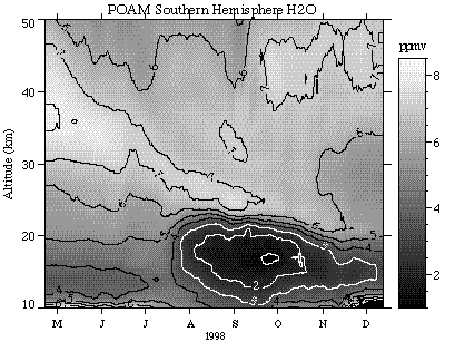
Figure 3.8. Water vapour mixing ratio as measured by POAM in the Southern Hemisphere from April to December 1998. The profiles are obtained as daily averages of the POAM measurements, which are taken at latitudes from 64°-88°S. There is strong descent within the vortex during the first half of the period. In July, cold temperatures in the lower stratosphere result in dehydration, which persists for several months. In October, lower latitude air begins to mix in above the vortex, resulting in a double peaked structure in the profile.
Time series of polar water vapour measurements furthermore show evidence of downward mass flux in the middle stratosphere throughout winter in both hemispheres. This is seen for the Southern Hemisphere in the POAM data in Figure 3.8 and in both polar regions in the seasonal cycle derived from combined HALOE and MLS data (Figure 3.9). Downward motion is most evident in the movement of high water vapour values, which originate in the summer upper stratosphere (the result of methane oxidation). Eulerian estimates of isopleth movement give a rough estimate of the descent rate. In Figure 3.9 isopleths suggest downward movement with magnitude of ~1.5 km/month, similar to values inferred from CH4 observations [Randel et al., 1998] and from radiative heating estimates [Schoeberl et al., 1995, Rosenfield et al., 1994] above 25 km. Lagrangian estimates of descent rates [Pierce et al. 1994, Manney et al. 1994] are a maximum of 1.5-4 km/month at 470 K [Manney et al. 1994]. A comparison of patterns in the Northern Hemisphere and Southern Hemisphere in Figure 3.9 suggests the high water vapour mixing ratios propagate more continuously throughout the winter in the Southern Hemisphere. This may be a result of the stronger isolation of the Antarctic vortex and with enhanced cross-vortex mixing in the Arctic [e.g., Bowman, 1993; Manney et al., 1994].
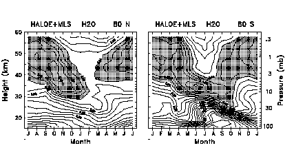
Figure 3.9. Altitude-time seasonal cycle of water vapour at 80°N (left) and 80°S (right) derived from seasonal cycle fits of HALOE+MLS data. Note the time axes are shifted by six months between the two panels to facilitate inter-hemispheric comparison.
Mid-latitude lower stratosphere
Evidence for a seasonal cycle of water vapour in the mid-latitude lower stratosphere was observed by Bannon et al. [1952]. The cycle was also described by Mastenbrook [1968, 1974] from balloon-borne frost point measurements taken from Washington DC between 1964 and 1973. The amplitude of the seasonal cycle was found to decrease from 1.2 ppmv at 90 hPa to about 0.6 ppmv at 60 hPa, with a relative maximum during summer. Mastenbrook and Oltmans [1983] presented the data updated to 1982. A similar data set with extended sampling has been obtained from frost point measurements made at Boulder, Colorado (40ûN) since 1979 [Oltmans and Hofmann, 1995]. Seasonal variability in the mid-latitude lower stratospheric water vapour has also been observed from in situ aircraft measurements [Hintsa et al. 1994, Dessler et al. 1995]. Figure 3.10 shows the average seasonal cycle over 1981-98 derived from balloon data over Boulder, Colorado, showing a pronounced annual cycle with a maximum during summer. These data show a relative minimum in the vertical profile of water vapour in the lower stratosphere, centred near 15 km in winter and near 18 km in summer. This minimum in the lower stratosphere is consistent with the zonal mean seasonal cycle seen in Figure 3.6. Such a minimum is impossible to achieve by local processes because water vapour is not locally close to saturation. Rather, this minimum is further evidence of rapid isentropic transport between the tropics and mid-latitudes in the lower stratosphere.
In mid-latitudes, care must be taken to separate seasonal variability from large amplitude meteorological variations, which can be substantial for infrequent and spatially localised measurements. One method to minimise such meteorological variations is to use the observed compact relationship between water vapour and long-lived tracers [e.g., Schoeberl et al., 1989, Boering et al., 1995]. Using simultaneous water vapour and N2O measurements taken on board the NASA ER-2 research aircraft during 1992-1993, Hintsa et al. [1994] showed how water vapour at mid-latitude in the Northen Hemsiphere exhibited a close relationship with N2O, and exhibited a seasonal cycle with higher values in fall than in spring.
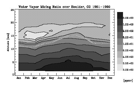
Figure 3.10. Altitude-time section of the seasonal cycle of water vapour at Boulder (40°N, 105°W), derived from frost point hygrometer measurements over 1981-1999. The solid line denotes the local tropopause.
Tropical lower stratosphere
There is a strong annual cycle in water vapour in the tropical lower stratosphere (Figures 3.6 and 3.7), with minimum values in January-April and maximum values during August-November. Hints of these seasonal variations were noted by Mastenbrook [1968] from balloon observations over Trinidad, and by Kelly et al. [1993] from high altitude aircraft data taken over Panama in 1980 and Darwin, Australia in 1987. On the basis of such limited observations, Kley et al. [1979] and others offered a number of hypotheses to explain the "elevated hygropause" - that is, the existence of a minimum in water vapour at altitudes higher than the local tropopause.
With the benefit of satellite observations like those shown in Figure 3.11, we now know [Mote et al., 1995, 1996] that the variably elevated hygropause moves vertically throughout the annual cycle and is produced by seasonal variations in saturation mixing ratios at the tropical tropopause. The water vapour minimum is transported slowly upward, with typical vertical velocities of ~0.3 mm s-1 [Rosenlof, 1995, Mote et al., 1998b], by the mean circulation, under conditions of very weak diffusion. The anomalies imprinted at the tropopause are identifiable for up to 18 months during which time they rise to altitudes of nearly 32 km. This phenomenon was termed the ‘atmospheric tape recorder’ by Mote et al. [1996].
Two aspects of the seasonal variations in tropical lower stratospheric water vapour offer clues about the dynamics of the lower stratosphere. First, the relationship in phase between the seasonal cycle measured in the tropics and mid-latitudes provides a measure of the transport time from the tropics to mid-latitudes. Angell and Korshover [1974] calculated a lag between tropical tropopause temperatures and stratospheric mid-latitude water vapour of a few months. From water vapour measurements presented by Mastenbrook and Oltmans [1983] (see also Figure 3.10) and McCormick et al. [1993], it appears that the seasonal cycle in mid-latitude lower stratospheric water vapour lagged that in the tropics by perhaps 2 months. Boering et al. [1995] inferred a transit time of 4-6 months in both November and May from the tropical tropopause (16.5 km) to 18-19 km in mid-latitudes. Volk et al. [1996] found a transport time scale from the tropics of less than 6 months below 19 km.
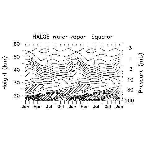
Figure 3.11. Altitude-time evolution of water vapour mixing ratio over the equator, derived from seasonal cycle fits of HALOE measurements. Two consecutive seasonal cycles are shown here.
The second aspect is the attenuation of the tape recorder signal itself, which can be used to deduce the rate at which mid-latitude air dilutes tropical air and simultaneously (provided other information is available as well) the vertical diffusion rate. Estimates of the dilution or in-mixing time scales between the tropics and mid-latitudes have been made using the tape recorder signal [Mote et al., 1996; Hall and Waugh, 1998; Mote et al., 1998b; Andrews et al., 1999] and also using other trace constituents [Avallone and Prather, 1996; Volk et al., 1996; Minschwaner et al., 1996; Herman et al. 1998]. The in-mixing time scales are generally in the range of 12-18 months, but Herman et al. [1998] found a value of 30 months, and the most detailed calculation (using HALOE data at high vertical resolution) included the effects of vertical diffusion, and found much longer mixing time scales, as long as 80 months at about 22 km [Mote et al., 1998b]. Collectively these studies suggest a region of strong mixing in the lower tropical stratosphere below about 20 km, and a region that is much more isolated from mid-latitudes between 20 km and about 28 km. This isolation has important implications for ozone chemistry and the ozone distribution in the tropical lower stratosphere [Avallone and Prather, 1996].
Extratropical lowermost stratosphere
The "extratropical lowermost stratosphere" is the region in middle and high latitudes above the tropopause but below isentropes of ~380-400 K. It is a dynamically distinctive region because it exhibits properties similar to the stratosphere (including low water vapour), but is closely connected to the low latitude troposphere by isentropes that cross the subtropical tropopause [Holton et al., 1995].
The main terms influencing the budget of water vapour in this region (also noted in Section 3.2.1) are (A) downward transport (of very dry air) from the stratosphere, (B) isentropic transport of (moist) tropospheric air from lower latitudes and (C) direct upward transport of air from the mid-latitude troposphere. The seasonal cycle of water vapour in this region is a powerful measure of the relative importance of these processes. Both in situ and satellite data show that water vapour in this region of the lower stratosphere has a pronounced seasonal cycle with a maximum in summer [Bannon et al. 1952, Mastenbrook, 1968, Dessler et al., 1995; Pan et al., 1997]. Figure 3.12 (identical to one of the panels in Figure 2.66) shows a comparison of the SAGE II and the MLS satellite with ER-2 aircraft measurements of the water vapour seasonal cycle in the Northern Hemisphere lowermost stratosphere. Winter mixing ratios are near 6-10 ppmv, characteristic of air with a large stratospheric component (A), whereas summer measurements show values of ~20-40 ppmv; a similar seasonal cycle is observed in the Southern Hemisphere [Pan et al., 1997]. These relatively wet summer measurements demonstrate that a significant component of the air either must originate in the low-latitude troposphere (B) or must be transported directly from the mid-latitude troposphere (C). This moist air can be seen in MLS data at 215 and 147 hPa, particularly over the Indian subcontinent in July-August [Newell et al., 1997]. Ray et al. [1999] have used long-lived halocarbons with corroborative water vapour data to estimate that a significant fraction of air in the northern hemisphere lower stratosphere below 360 K must have originated in the low latitude upper troposphere without having passed above the 380 K surface, as discussed by Dessler et al. [1995]. In September, most of the air is from the tropics (B), while in March most of the air comes from higher altitudes in the extratropical stratosphere (A) [Ray et al., 1999].
The Northern Hemisphere lowermost stratosphere below 380 K is in general wetter than the Southern Hemisphere lowermost stratosphere [Pan et al., 1997, Rosenlof et al., 1997]. The largest hemispheric asymmetry is in Northern Hemisphere summer and fall. Differences in summer and fall seasons between the two hemispheres are probably related primarily to differences in the summer monsoon circulation, which is stronger in the Northern Hemisphere. Exchange of water vapour from the troposphere into the stratosphere during the season of the Asian monsoon significantly moistens the northern hemisphere lower stratosphere, as illustrated by Rosenlof et al. [1997] with HALOE observations, and Gettelman et al. [2000] using a transport model. Dethof et al. [1999], using contour advection, suggest that mid-latitude disturbances pull filaments of water vapour rich air from the northward flank of the Asian monsoon anticyclone. Other asymmetries between hemispheres include annual variations in the strength of upward (tropical) and downward (extratropical) motion associated with the Brewer-Dobson circulation [Rosenlof 1995] and the influence of polar dehydration at higher latitudes of the Southern Hemisphere.
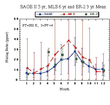
Figure 3.12. Seasonal cycle variation of water vapour from SAGE II, MLS and ER-2 aircraft measurements for the ±5 K layer centred on the 350 K isentrope and 3<PV<4 (typically 40°-50°N). The SAGE II data represent five-year means (1986-1990), MLS are six-year means (1992-1997), and the aircraft data cover the STRAT/POLARIS missions (1995-1997). Error bars indicate the RMS deviation from the mean.
3.3.2 Upper Troposphere
Several satellite data sets provide information on moisture in the upper troposphere, with near-global coverage and multi-year records that provide accurate characterisation of the annual cycle. Two data sets discussed here include relative humidity estimates derived from HIRS and MLS (MLS data are also converted to mixing ratio using NCEP global temperature analyses). The HIRS retrieval is sensitive to relative humidity in a layer from approximately 5-11 km in the tropics, and 4-8 km in the extratropics. MLS data give vertical profile estimates for ~3 km thick layers centred on pressure levels 316, 215, and 147 hPa (~8, 11 and 13.5 km, respectively). In situ data will also be shown for corroboration of the satellite-observed behaviour.
Observations: tropical and subtropical upper troposphere
The seasonal cycle of HIRS-derived upper tropospheric humidity (UTH) is shown in Figure 3.13, in the form of latitude-longitude maps for each season. Within the deep tropics, the maxima in UTH in the annual mean (Figure 3.5) over the African monsoon, the Austral-Asian monsoon, and the American monsoon, appear throughout the year but with a large seasonal excursion of each monsoon centre. In December-January-February (DJF) the monsoon centres and maxima in UTH are found over Southern Africa, Indonesia, and the Amazon. In June-July-August (JJA), strong maxima in UTH appear north of the equator over the Indian monsoon, and other maxima are found over North Africa and Central America. Over the Pacific Ocean, moist signatures of the Intertropical Convergence Zone are present in northern-hemisphere summer and fall, and the South Pacific Convergence Zone is most pronounced in the Southern Hemisphere summer.
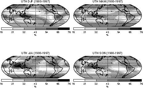
Figure 3.13. Long-term seasonal means (1979-1998) of upper tropospheric humidity over ice derived from HIRS data.
The very dry regions of the subtropics also undergo strong seasonal shifts, occurring particularly in the winter hemisphere. Especially notable are dry regions occurring over the Atlantic and Pacific oceans (~15°-40°N) in December-January-February, and over 15°-40°S during June-July-August. Large areas off the west coasts of South America and Australia are relatively dry year-round, but still with significant seasonal modulation. A dry region also appears during JJA northwest of the Asian monsoon. The exceeding dryness of these regions is illustrated further in Figure 3.14, where daily MLS data show that relative humidity < 10% is observed for up to 70% of the observations in these regions [Stone et al., 2000]. Similar dryness statistics have been found in SSMT2 data [Spencer and Braswell, 1997].
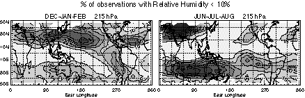
Figure 3.14. Percentages of MLS upper tropospheric humidity observations (at 215 hPa) during 1991-97 in which relative humidity values are less than 10%. Contour interval is 10%. From Stone et al. [2000].
Seasonal water vapour variability in the upper troposphere is closely tied to the vertical circulation cells associated with the seasonal Hadley and Walker circulation. Following Newell et al. [1996] and Stone et al. [2000], this is demonstrated in Figure 3.15, which shows the 215 hPa water vapour mixing ratio derived from MLS data superimposed on the divergent circulation velocity potential (statistics derived from NCEP data) for December-January-February and June-July-August. These show that upper tropospheric water vapour maxima are associated with upward motion and minima with downward circulation, and show that water vapour seasonality is closely tied to the meridional movement of tropical convective upwelling. This meridional movement is further highlighted in Figure 3.16, which shows the seasonal variation of zonal mean MLS mixing ratio at 215 hPa during 1991-93. This meridional motion mimics that of the Intertropical Convergence Zone throughout the year (see, for example, Hartmann, [1994]). Similar seasonality is observed for MLS retrievals at 316 and 147 hPa, with the average mixing ratio dropping by at least a factor of two between adjacent vertical layers [Read et al., 1995].
Observations: Mid-latitude upper troposphere
Mid-latitudes also experience significant seasonal changes in upper-tropospheric moisture, but with a few features that persist throughout the year, as can be seen in Figure 3.13 from HIRS. At middle latitudes, the HIRS retrievals represent altitudes of ~4-8 km (which is below the extratropical tropopause). Figure 3.13 illustrates relatively little longitudinal structure compared with the tropics and subtropics, but moist areas are evident throughout the year off the West coast of Southern South America and in the Northeast Pacific and Atlantic areas. Enhanced descent and equatorward flow to the east of the semi-permanent surface oceanic anticyclones is associated with upper tropospheric dryness, while enhanced ascent and poleward flow to the west of these anticyclones is associated with moist anomalies. Overall, the relative humidity is greater in winter than summer.
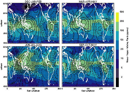
Figure 3.15. Seasonal averages of MLS upper tropospheric water vapour mixing ratio on the 215 hPa surface, overlaid with contours of velocity potential (in increments of 200x104m2s-1) and divergent wind vectors (with maximum amplitude of 7.6 ms-1). From Stone et al. [2000].
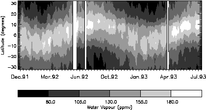
Figure 3.16. Variation in zonally-averaged upper tropospheric water vapour (at 215 hPa) in the tropics during 1991-1993, derived from MLS data.
Observations over Boulder, Colorado (40ûN, 105ûW) using the NOAA frost point balloons indicate a strong annual cycle in water vapour mixing ratio, with summer values at 10 km higher than those in winter by a factor of ~6 (Figure 3.10). This is far greater than the changes in relative humidity indicated by HIRS, indicating that seasonal changes in specific humidity here are predominantly related to the seasonal variations in temperature. Note also that the tropopause height has a large annual cycle, such that the water vapour mixing ratio (as well as the relative humidity) at the tropopause is actually lower in summer than in winter. A more extensive climatology of water vapour in the mid-latitude upper troposphere is available from data on commercial aircraft, taken as part of the MOZAIC project (Section 1.1.5). Data from the North Atlantic in two different latitude bands is presented in Figure 3.17a (mid-latitudes, 40-60 N) and Figure 3.17b (subtropics, 20-40N). In the mid-latitude belt the specific humidity has a strong seasonal cycle similar to that shown in the frost point balloon data, with a pronounced winter minimum of 0.03 gkg-1 (~50 ppmv) and late summer a maximum of 0.09 gkg-1 (~140 ppmv). The specific humidity cycle follows the seasonal changes of temperature. The most pronounced changes of the specific humidity are coincident with the sudden temperature increase of 5-7 K in May-June and the rather steep temperature drop of 5-7 K in November-December. In summer and fall in mid-latitudes, the specific humidity is a factor of 2 larger than in Winter-Spring, while the temperature in Summer-Fall is about 7 K higher. However, the corresponding relative humidity of about 85% with respect to ice in Summer-Fall is about 10% lower than in Winter-Spring, a change consistent with that shown by HIRS. Similar seasonal behaviour of moisture was found at the 500 hPa level by Gaffen et al. [1992].
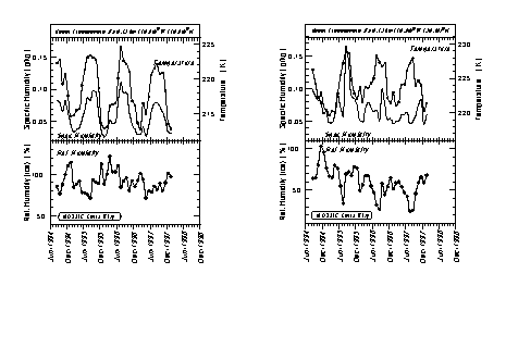
Figure 3.17. Seasonal variation of specific humidity, temperature, and relative humidity over ice in the upper troposphere (PV<2 PVU) over the North Atlantic, sampled during MOZAIC flights at 9-12 km between August 1994 and January 1998. Results are shown for the mid-latitudes (40°-60°N, left) and the subtropics (20°-40°N, right). Data coverage is about 60 flights/month at mid-latitudes and 20 flights/month in the subtropics.
In contrast to mid-latitudes, in the sub-tropical belt (Figure 3.17b) the seasonal cycle in specific humidity is not as pronounced as the large interannual variability. The specific humidity is about 0.08 gkg-1 (~130 ppmv) in Summer-Fall and 0.06 gkg-1 (100 ppmv) in Winter-Spring, and is positively correlated with temperature whose corresponding seasonal means are roughly 225.0°K (-48°C) and 221.8°K (-51.2°C) respectively. For comparison, the relative humidity in Summer-Fall of about 57% is about 10% lower than in Winter-Spring. Thus, mean relative humidity from 20°-40°N is about 30% lower than from 40°-60°N. The same conclusion can be drawn from the HIRS UTH data in Figure 3.13.
The observed sudden changes of temperature and specific humidity, particularly within the mid-latitudinal belt, are probably due to changes of the large-scale circulation over the North Atlantic. These changes can be related to the seasonal northward migration of the subtropical jet stream from 30°N to 40°N in April-May and southwards from 40°N to 30°N in October-November. In the summertime, continental convection plays an important role in the water vapour distribution, as the storm tracks are weaker and move farther poleward.
Mechanisms influencing the global upper troposphere
The data presented in this report and many previous studies clearly indicate that upper tropospheric water vapour is influenced by dynamics and by seasonal changes in temperature. The ability of dynamics to influence relative humidity and mixing ratio follows from the steep slope of the Clausius-Clapeyron equation, i.e. the rapid increase in water vapour holding capacity of the atmosphere with increasing temperature. The environmental lapse rate then leads to a rapid decrease of water vapour mixing ratio with altitude, characterised by a scale height of ~2 km. Because of this vertical gradient, vertical motions can quickly lead to large changes in mixing ratio at a given altitude. By the same token, adiabatic lifting of an unsaturated air mass lowers its temperature without changing its mixing ratio, thus increasing its relative humidity. Such lifting can quickly lead to saturation. Dynamical influences are also, however, associated with sources and sinks of water vapour, complicating matters as will be discussed below. In the tropical upper troposphere, horizontal temperature variations are small, so horizontal structure in moisture is similar whether viewed in terms of relative humidity or mixing ratio. Outside the tropics this is not generally true.
Global horizontal transport of total water occurs most readily on isentropic surfaces, making these a useful vertical coordinate. These surfaces are approximately level (hence isothermal) in the tropics and slope downward in the sub-tropics, but slope upward at higher latitudes, reaching colder temperatures. In the tropics, moist air is injected into the middle and upper troposphere in convective systems. Tropical air parcels that move isentropically to the extratropical upper troposphere encounter significantly lower temperatures and thus attain (on average) higher relative humidity. This is especially true in the winter (colder) hemisphere, leading to the higher relative humidity observed in this season. The high relative humidity in the extratropics overall leads to significant loss of water vapour through precipitation, leaving large, seasonal excursions in temperature to be the dominant regulator of the annual cycle in specific humidity. Air that returns to the tropics from high latitudes will have been dehydrated by the colder temperatures; also, moist tropical air that remains in the tropics, after precipitating (removing water), gradually cools and sinks to lower isentropes and higher temperatures. The air thus experiences a gradual decrease in relative humidity. The combination of isentropic and convective transport accounts for the coexistence of dry and moist air in the tropics and subtropics (though they do not apply close to the tropopause). This "big picture" ignores many important meteorological details, some of them as yet poorly understood, and relies upon a number of supporting arguments. Furthermore, much work remains to be done before water vapour can be reliably simulated in climate models. Many of these matters are discussed in the following sections.
Tropical mechanisms
Upper tropospheric water vapour is maintained through balance between moistening by detrainment from updrafts and/or large-scale ascent, drying by condensation or freezing of water vapour in updrafts, and moistening by re-evaporation of detrained hydrometeors and precipitation. These mechanisms may be broadly divided into dynamics (or advection), and sources/sinks due to hydrometeor transport. Dynamics in the tropical troposphere is dominated by diabatic motion, ranging from the global-scale Hadley and Walker circulation all the way down to transient cumulus cells. Unfortunately, since hydrometeor sources and sinks are themselves almost completely controlled by the dynamics, it is not easy to discuss these two mechanisms separately. Instead, this discussion will begin with the rising, moist branches of the general circulation (including embedded convective motions and mesoscale organisation of these motions), and end with the sinking, dry branches of this circulation.
The planetary-scale tropical circulation is quasi-steady. Ascending branches tend to prefer certain regions, typically over warm surfaces like the tropical west Pacific, and coincide with convection. The circulation may be understood as a response either to the deep convective heating that occurs over warmer surfaces [Gill, 1980] or to forces generated by horizontal gradients in boundary-layer air temperature [Lindzen and Nigam, 1987]. Their ascending regions are generally much moister than elsewhere, accounting for the tropical patterns shown above by HIRS. Further, it is clear from recent satellite observations that high tropical UTH tracks the large-scale ascent and convection as it moves seasonally, intraseasonally, and interannually [Soden and Fu, 1995; Clark et al., 1998; Sandor et al., 1998; Chen et al., 1999]. However, it must be remembered that due to variability on shorter time scales, even favourable areas sometimes experience dry, stable periods [Graham and Barnett, 1987; Lin and Johnson, 1996]. Such dry periods are associated with a break in the usual large-scale ascent pattern.
In principle, the tight association observed between ascent and high moisture could easily be explained on the basis of the dynamical arguments given earlier, but the effects of smaller-scale motions complicate matters. The large-scale view is indeed bolstered by the fact that the moisture supply to balance precipitation comes not from surface evaporation, which shows no systematic relationship with convection on large space and time scales, but from large-scale atmospheric transport and low-level convergence of moist air [Cornejo-Garrido and Stone, 1977]. On the other hand, the upward motion in areas of large-scale ascent is actually concentrated exclusively within relatively narrow, saturated, convective-scale and mesoscale updrafts, which generate evaporative sources of water vapour for nearby air in the mid- and upper levels [Riehl and Malkus, 1958; Houze, 1977]. This too is a way of explaining the high relative humidity in regions of large-scale ascent. These differing viewpoints on the scale of the processes controlling the water vapour distribution have fuelled debate within the scientific community as to how best to approach tropospheric water vapour.
The convective-scale motions, with velocities of up to 50 ms-1 or more and horizontal scales of ~10 km, serve both to transport material and energy vertically and to condense great amounts of water vapour. The condensation liberates the heat required to balance the general circulation [Gill, 1980], while the convective transport creates an additional upward flux of moisture, or flux convergence in the upper troposphere. Furthermore, these convective motions generate liquid and ice clouds that exit the updrafts and spread horizontally.
Such behaviour is observed to be highly organised on the mesoscale (~100 km). In the classical squall line [e.g., Houze, 1993, p. 348ff], a large mesoscale region of stratiform anvil cloud and slow (~ 1 ms-1) upward motion above the freezing level is fed by the strong convective updrafts at the leading edge of the line. Ice particles continue to grow and fall slowly through the anvil, removing water substance. The top of this mesoscale updraft is at or just below the tropopause, where the air motions are downward; this is probably a mesoscale gravity wave response of the stable upper troposphere to the strong upward motion at the leading edge of the squall line [Johnson et al, 1990]. A third to a half of the total precipitation from major convective systems comes from this stratiform region. This precipitation moistens the unsaturated layer below the anvil through evaporation, which sinks in a "mesoscale downdraft."
Away from the ascending branches of the general circulation, small-scale vertical transports, sources, and sinks appear to be less important, and the picture is dominated by advection by large-scale horizontal motions in a slowly subsiding environment. While cloud evaporation may account for the observed decrease in UTH at increasing distance from convective systems [Udelhofen and Hartmann, 1995], typical water contents of non-precipitating clouds are small compared to the water vapour content in a relevant portion of the atmospheric column [e.g., Strom and Heintzenberg, 1994]. Sherwood [1999a] found that the water vapour field is so sensitive to dynamics that the radiative effects of typical cirrus clouds should drive sufficient vertical motions to produce greater moist anomalies than are produced by actual sublimation of the cloud ice. Accordingly, there is growing evidence that throughout the middle and upper troposphere away from convective systems, moisture levels are determined to good approximation simply by the character of the motion field at large scales with no attention paid to additional sources. This has been tested by performing calculations using analysed wind fields where the humidity in cloudy or ascending regions is somehow brought (or assigned) to a near-saturated value, then comparing globally-predicted humidity to that observed by a variety of observational platforms [Sherwood, 1996b; Salathé and Hartmann, 1997; Pierrehumbert and Roca, 1998; Dessler and Sherwood, 2000].
These results imply that in principle, general circulation models should be able to simulate the water vapour fields well in a coarse-grained sense if they have good energetics, dynamics, and numerics. Though models and assimilation products generally produce reasonable moisture patterns, most are unfortunately not dry enough in the most arid regions. Studies of this problem [Soden and Bretherton, 1994; Salathé et al., 1995; Sherwood, 1996a] lead to the conclusion that in the models studied, parameterised convection typically mixed too much moisture out of the boundary layer under conditions where little or no transport really occurs. Numerical problems in model advection may also limit the ability of general circulation models to reproduce the steep curvature of the vertical water vapour profiles in areas of (presumably) little real mixing. Conversely, some assimilation products are not moist enough in convective or high-relative-humidity regions [Lin and Johnson, 1996, Ovarlez et al., 2000]. This is probably due to forecast model problems though data problems may also be responsible. Model representation of convection and its interaction with moisture continues to be an active area of research.
Extratropical mechanisms
Almost all of the discussion of the tropics also applies to the extratropics, but a few unique aspects are discussed here. These include the importance of coherent synoptic circulation patterns, the seasonality of convection, and interaction with the stratosphere.
During most of the year (fall through mid-spring), cyclonic, baroclinic disturbances dominate the regulation of extratropical upper tropospheric water vapour [Stone et al., 1996]. These large-scale disturbances advect moisture poleward and upward from the tropics and subtropics. The correlation of upward and poleward flow in the disturbances is characteristic of the unstable baroclinic waves that initiate the disturbances [cf. Pedlosky, 1979, p. 452]. The adiabatic cooling of the poleward-moving air produces widespread cloudiness extending to the top of the troposphere, especially during the winter season along the mid-latitude storm tracks. This can be seen in the enhanced cloudiness in cloud climatologies of high clouds along the mid-latitude storm tracks (e.g., HIRS climatologies, Wylie and Menzel, [1989]), and, to a lesser extent, in upper tropospheric MLS water vapour climatologies [e.g., Sandor et al., 1998; Haas and Pfister, 1998]. The flow that returns to the tropics and subtropics sinks quasi-isentropically and is quite dry, having lost its water vapour to precipitation in the mid-latitudes. This process has been described by Yang and Pierrehumbert [1994] as "quasi-isentropic advection-condensation." At lower latitudes, poleward-propagating Rossby waves may enhance this process. Iskenderian [1995] has shown that in certain preferred regions, such as the eastern tropical Pacific, mid-latitude Rossby waves can propagate deep into the tropics and excite convection there. The result can be a so-called "moisture burst" [McGuirk et al., 1988] that has a strong southwest-northeast tilt. The quasi-isentropic process also appears to extend to high latitudes, producing lower upper-tropospheric mixing ratios at middle and high latitudes in the Southern Hemisphere (where polar regions get colder) than in the Northern Hemisphere, during their respective winters [Kelly et al., 1991].
Local transport across isentropes is also important at mid-latitudes. Buoyancy-driven convection, not directly associated with baroclinic instability, is quite extensive in the summer mid-latitudes and often extends all the way to the tropopause [Poulida et al., 1996]. This summertime convection resembles that described previously for the tropics, including convective and mesoscale features that transport moisture vertically in solid, liquid, and ice phases. Its contribution to upper tropospheric water vapour is clear, for example, in the comparisons between MLS upper tropospheric water measurements and HIRS high altitude cloudiness shown by Haas and Pfister [1998]. Water vapour and convection are enhanced over the major convective zones in the North American and Asia/Western Pacific regions. Quantitative evidence of the importance of local convection is given by Yang and Pierrehumbert [1994], who noted that their quasi-isentropic advection-condensation model predicted an excessively dry upper troposphere if only tropical sources of water vapour were considered.
As in the tropics, upper tropospheric moisture at middle and high latitudes is ultimately limited by condensation of moisture in excess of saturation, resulting in rapidly decreasing water vapour mixing ratio with height. However, recent in situ water vapour measurements have shown that large supersaturation with respect to ice (relative humidity with respect to ice up to 160%) is common in the mid-latitude upper troposphere, both in clear and cloudy regions [e.g., Heymsfield et al., 1998; Jensen et al., 1998a, 1999; Gierens et al., 1999; Vay et al., 2000]. This high supersaturation is consistent with recent laboratory experiments that indicate large supercooling is required to initiate ice cloud formation by freezing of sulphate aerosols [Bertram et al., 1996; Koop et al., 1998]. In fact, the common occurrence of clear-sky, upper tropospheric supersaturation is necessary to explain the frequent observations of persistent contrails [Brewer, 1946].
Another influence on upper tropospheric humidity is irreversible, turbulent mixing with stratospheric air in the tropopause region. Long, narrow streamers of dry upper tropospheric air are often apparent in satellite water vapour imagery [e.g., Appenzeller and Davies, 1992]. These streamers are caused by intrusions of stratospheric air into the upper troposphere from tropopause folding events [Reed, 1955]. These eventually dry the upper troposphere [Langford and Reid, 1998], though quantitative analysis of their overall impact on the upper tropospheric water vapour budget is challenging because of the complexity and small spatial scales of the events [Cox et al. 1995].
Models of the tropospheric water vapour distribution and climate
Mechanistic theories of the water vapour abundance in the middle and upper troposphere and its sensitivity to climate change appearing in the literature have mostly focused on convective transport with a tropical emphasis. Here, the relevant issues are those determining the detrainment profile of water vapour from convective elements [Lindzen, 1990], the "precipitation efficiency" or fraction of plume moisture that is removed as precipitation [Rennó et al., 1994], and the microphysical properties of ice after it has detrained from the plumes [Sun and Lindzen, 1993]. Climate change studies using such models often predict that relative humidity in the middle and upper troposphere would decrease in warmer climates, i.e., that there would be a weaker or negative water vapour feedback [Lindzen, 1990; Sinha and Allen, 1994].
The above approaches neglect the role of horizontal mixing and large-scale processes, whose possible role in influencing climate variations has been discussed by Betts [1990], Yang and Pierrehumbert [1994], Salathé and Hartmann [1997], and Pierrehumbert and Roca [1998]. The cumulus-based approaches also do not consider mesoscale convective features and organisation. A recent simple model incorporating explicit control of moisture by the large-scale circulation rather than by draft physics [Sherwood, 1999b] found a positive water-vapour feedback, in agreement with those found by general circulation models.
The importance of large-scale dynamics to the present moisture distribution and its radiative impact, which is becoming increasingly apparent, suggests that models (such as general circulation models) that represent both global and cumulus-scale processes will be required to simulate water vapour sensitivity dependably. General circulation models are also beginning to include aerosols and their interaction with cloud processes [e.g., Lohmann et al. 1999]. These interactions may produce climatic variations in relative humidity in addition to those resulting from dynamics. Though such models carry water vapour as a prognostic variable and explicitly simulate the large-scale circulation, they include convection only through relatively crude physical parameterisations. Also, they may lack the proper vertical resolution to simulate the convective influence on water vapour correctly [Tompkins and Emanuel, 2000]. Further, many models in use today exhibit significant moisture biases [Gaffen et al., 1997, Bates et al., 1997]. Thus, there is much room for development and validation of these models before their water vapour feedback predictions can be fully trusted.
3.3.3 The Tropical Tropopause Region
Because the tropical tropopause region (between 15-20 km altitude or about 150 and 70 hPa) plays a critical role in governing the distribution of water vapour in the lower stratosphere, the seasonal variability at the tropical tropopause and the processes responsible for it are treated here in a separate section.
Observations
Observations of water vapour in the tropical tropopause region are extremely limited. Some isolated frost point measurements using aircraft were performed over tropical Africa in June 1958 [Kerley, 1961] up to 15km, indicating frost points as low as -80°C (~4 ppmv). The seasonal cycle of water vapour in the tropics was illustrated by Mastenbrook [1968] over Trinidad (17°N) using a frost point hygrometer. Kley et al. [1979] measured water vapour up to 20 km in September 1978 from a balloon over Brazil. Measurements were also taken from two campaigns aboard the NASA ER-2 research aircraft in different seasons in 1980 and 1987 as part of the STEP project [Kley et al. 1982, Kelly et al. 1993]. The CEPEX campaign measured water vapour in the tropical tropopause region using aircraft [Weinstock et al. 1995] and balloons [Vömel et al. 1995b] and several mid-latitude aircraft campaigns also have flown into the tropics. More recently, the MLS instrument and the HALOE instrument on UARS measure water vapour in the upper troposphere and lower stratosphere respectively. All these observations are consistent with the annual cycle illustrated in Figure 3.11 (derived from HALOE data). Air in the tropical tropopause region is driest in Northern Hemisphere winter, and wettest in Northern Hemisphere summer. While the basic picture of ascent in the tropics driven by the mean meridional circulation presented in section 3.3.2 can explain many of these observations, it cannot explain some of the details, such as the extremely dry July hygropause of 2 ppmv noted by Kelly et al. [1993]. To explain these observations, the source and sink terms for water vapour in the tropical tropopause region are important.
Observations of clouds provide the key source or sink terms for water vapour in the tropopause region. It has long been known that deep convective clouds may penetrate the tropopause in mid-latitudes (see for example Roach [1966]). In situ evidence from aircraft [Kelly et al. 1993, Danielsen, 1993] and evidence from satellites [Ebert and Holland, 1992] clearly show that some convective clouds also penetrate the tropopause in the tropics. These clouds are extremely cold with ice recorded at up to 18 km or 75 hPa [Danielsen 1993] and saturation mixing ratios measured below 2 ppmv by Kelly et al. [1993] and as low as 1 ppmv by Vömel et al. [1995b]. The extent of this deep penetrating convection is currently uncertain. Robinson and Atticks-Shoen [1987] have estimated that observations of very cold clouds are of sufficient frequency to supply mass to the stratosphere. Zhang [1993] has noted that there is a seasonal cycle in the coldest clouds in the tropics, with maximum frequency of the coldest cloud tops (T<200°K) peaking in boreal winter (January) throughout the tropics.
In the tropical upper troposphere, horizontal patterns of water vapour near the tropopause are like photographic negatives of those at lower levels. That is, convective areas tend to be drier than non-convective areas near the tropopause and wetter than non-convective areas farther down. The level at which the transition occurs lies somewhere between 100 and 150 hPa; unfortunately the vertical resolutions of the various upper tropospheric water vapour data sets are inadequate to locate this reversal level more precisely. These patterns appear both in long-term means [Rind et al., 1993] and connected with the tropical intraseasonal oscillation [Mote et al., 2000]. Other time scales have not been investigated, but Reid and Gage [1996] examined temperature variations at Truk Island in the tropical Pacific and found that both the seasonal cycle and the daily variations at levels above 125 hPa tended to be oppositely correlated with variations at levels below 125 hPa. The reversal between is consistent with rising motion below and sinking motion above anvil top with a crossover at 125 hPa in the tropics as measured in stratiform cloud systems by Balsley et al. [1989].
Interpretation
Near the tropopause (~100 hPa), mechanisms not previously considered may become important. One key difference is that above 150 hPa, the tropical troposphere typically becomes more stable, in contrast to the consistently near-adiabatic profiles between 150 and 300 hPa. This region of the atmosphere is therefore better able to support wave activity than lower levels, and the waves will have much greater temperature signatures. For example, Tsuda et al. [1994] have shown that Kelvin waves can perturb the tropical tropopause temperature by upwards of 4 K; this implies a factor-of-two variation in saturation mixing ratio. Short period gravity waves generated by convection have been observed in the tropopause region [Pfister, 1986; Alexander and Pfister, 1995]. These gravity waves cause temperature fluctuations that may cause cirrus clouds to form [Potter and Holton, 1995]. The effects of these clouds are discussed further below.
A second unique feature of this region is that radiative transfer models predict net radiative heating above 150 hPa in the absence of clouds [e.g., Folkins et al., 1999], in contrast to net cooling that occurs elsewhere in the troposphere. The very dry air observed at the cold tropical tropopause, generally occurs at potential temperatures considerably greater than the equivalent potential temperature of the surface [Selkirk, 1993], implying that air at the tropopause has been radiatively heated. Only in the regions of most active deep convection (such as over the warm pool in the western Pacific) does the tropopause reach potential temperatures near the equivalent potential temperature of the surface. The stability and radiative heating of this region, together with trace gas measurements, imply a weakening of vertical mixing and a transition to slow ascent [Folkins et al., 1999]. The ascent should lead to high relative humidity and increased cloud occurrence just below the tropopause. As pointed out by Robinson [1980], large-scale ascent would cause thick cirrus decks to form in the upwelling regions. High relative humidity indeed appears in recent satellite vapour measurements [Jensen et al., 1999], as do large sheets of thin cirrus [Wang et al., 1996].
High relative humidity and supersaturation (relative humidity>100%) are often observed at the tropical tropopause region, with high values above convective regions, but with relative humidity still near 50% in the subtropics [Jensen et al., 1999]. This high humidity indicates that water vapour in the tropical tropopause region is critically dependent on the saturation vapour mixing ratio, and hence the temperature. The seasonal variation in tropical stratospheric water vapour is linked to the seasonal cycle in tropical tropopause temperature [Weinstock et al. 1995; Mote et al., 1995]. Temperatures in the tropical tropopause region have important variations in space and time, which have long been known [e.g., Reed, 1962; Staley, 1962; Reed and Vlcek, 1969]. The tropical tropopause temperatures are coldest in boreal winter (December to February) and highest in boreal summer (July-August) [Newell and Gould-Stewart, 1981; Atticks and Robinson, 1983]. This cycle can also be seen in the temperature of the coldest point in the temperature profile [Zhou, 2000b] and satellite observations of upper troposphere/lower stratospheric temperatures [Yulaeva et al, 1994]. The annual cycle in temperatures is evident below the tropopause to 125 hPa [Reid and Gage, 1996]. The structure of temperature variations on the tropical tropopause has been discussed as a response to large scale tropospheric heating by Highwood and Hoskins [1998], and the interannual variations of the tropical tropopause in response to El Nino and the Southern Oscillation and the Quasi-Biennial Oscillation have been discussed by Reid and Gage, [1985], Gage and Reid, [1986], and Reid, [1994] among others (see section 3.4.2).
At the tropical tropopause (in Figures 3.6 and 3.11) the driest air occurs in the winter hemisphere, in both January and July, whereas the ascent in the Intertropical Convergence Zone is stronger in the summer hemisphere. One explanation of the wintertime dryness is that vertical convection on the winter side of the equator is deeper [Tuck et al. 1997], and hence colder and drier. A more comprehensive explanation notes that the dry air in the subtropics is consistent with forced ascent by a wintertime 'dynamical pump' driven by wave forcing driving air poleward at high altitudes and upward in the tropics [Haynes et al., 1991; Holton et al., 1995]. In theory this upwelling occurs more strongly in the winter hemisphere, though there are limitations outlined by Plumb and Eluszkiewicz [1999], who argue that tropospheric thermal forcing may also be necessary to explain the observed upwelling in the tropics. The observed upwelling at 100 hPa is centred over the equator, and in the middle stratosphere is in the summer hemisphere [Eluszkiewicz et al., 1996]. This wave-driven circulation is consistent with the annual cycle of temperature and of the sheets of cirrus clouds.
Large sheets of thin cirrus might constitute evidence of slow ascent. Significantly, the areas where thin cirrus are commonly observed [Wang et al., 1996] are also the regions of coldest tropopause temperatures [e.g., Newell and Gould-Stewart 1981]. Thin cirrus is formed both in situ and by convective outflow [Winker and Trepte, 1998]. Newell and Gould-Stewart [1981] concluded from monthly-mean 100 hPa temperatures that the tropical tropopause was generally too warm to explain the extremely dry stratosphere unless the ascent was temporally and spatially limited to a "stratospheric fountain" in the coldest regions. The full three-dimensional circulation may be much more complicated. Gage et al. [1991] examined vertical velocities in the upper tropical troposphere and proposed that ascent may be occurring in regions of clear sky above the downward branch of the Walker circulation. The downward branch of this "reverse Walker" circulation would be found over convective regions, as noted by Sherwood [2000] and seen in the analysis of Simmons et al. [1999]. However, uncertainties in water vapour concentrations and in the temperature and vertical velocities in the region of the tropical tropopause are currently too great to determine whether ascent is predominantly widespread or localised and predominantly slow or fast (see Vömel and Oltmans [1999] and Dessler [1999]).
Cirrus, water vapour, radiation, and temperature undoubtedly interact through a variety of mechanisms that are not yet understood. The formation and maintenance of cirrus clouds involves dynamics, radiation, and microphysics [Jensen et al., 1996b]. These clouds can both moisten the tropopause region by radiatively induced heating [Rosenfield et al., 1998] or radiatively induced upward advection of water vapour "radiative pumping," [Sherwood, 1999a]. Cirrus clouds may also dehydrate the tropopause region by radiative destabilisation of anvils formed in the stratosphere from penetrating convection Danielsen [1982] or by ice fallout [Jensen et al., 1996a]. Unfortunately, model simulations of cirrus are at present poorly constrained due to lack of good data on cloud composition and water vapour. Observations suggest some degree of supersaturation occurs below the tropical tropopause [Jensen et al., 1999], indicating the potential sensitivity of moisture levels there to microphysical behaviour.