3.2 Mean Distribution of LS/UT Water Vapour
The mean distribution of water vapour is best described using global satellite data sets, which offer a large number of measurements in space and time. In the stratosphere, we focus on data from HALOE and to a lesser extent MLS and POAM. In the troposphere, we focus on data from HIRS and MLS.
Trace constituents in the stratosphere, water vapour included, tend to have relatively small variations along a latitude circle except in the lower-most stratosphere. These variations are even smaller along a streamline and smaller still along a curve with constant potential vorticity (PV) and constant potential temperature (q). The zonal dimension adds little information about water vapour, at least once the zonal variations of the flow have been noted. Therefore, most of the results we show in the stratosphere either have been zonally averaged or have been averaged along a PV-q contour.
In the troposphere, by contrast, the water vapour distribution is more fully three-dimensional, with very large variations (up to four orders of magnitude) in the vertical. Even so, in the tropics and subtropics, the horizontal patterns are qualitatively similar over a considerable range of altitudes, so that the vertical variations can to some extent be ignored. Therefore, for the troposphere, we focus on horizontal variations.
3.2.1 Lower Stratosphere
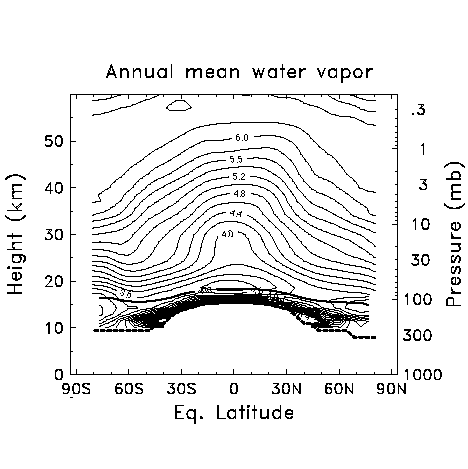
The annual mean water vapour distribution in the lower stratosphere is shown in Figure 3.3. The key features are a sharp vertical gradient at the tropical tropopause and in the extratropical lower stratosphere, a minimum in the tropics at or just above the tropopause, and gradual increases upward and poleward. Following Kley et al. [1979], we refer to the minimum in water vapour as the "hygropause," and we note that in the annual zonal mean it occurs near the 400 K potential temperature surface. As noted in Chapter 2, HALOE has a slight dry bias at these altitudes, so it is possible that the sharpness of the dry feature in Figure 3.3 is an exaggeration.
Before discussing the mechanisms responsible for producing these features, we first describe how the figure was constructed. HALOE water vapour measurements for the years 1991-1999 were averaged following the method of Randel et al. [1998], making use of MLS data in polar regions only to fill in gaps in the HALOE coverage. The data are averaged following a PV-q contour (see above) and then mapped to the "equivalent latitude" [Buchart and Remsberg, 1986] of the PV contour, i.e., the latitude at which the area enclosed by a latitude circle equals the area enclosed by the PV contour. Equivalent latitude better preserves geophysical gradients around the polar vortex by classifying air dynamically [see Randel et al., 1998]. Outside of polar regions the values are nearly identical to zonal means. The vertical sampling of these HALOE data is ~0.3 km and it has a vertical resolution of ~2 km, with observations available in cloud-free regions above the tropopause.
The key features in the mean distribution can be understood primarily as a balance among the following processes: (1) a mean meridional circulation, (2) stratospheric photochemistry, (3) dehydration at the tropical tropopause, (4) seasonal dehydration in the polar regions and (5) a variety of processes through which tropospheric moist air leaks into the extratropical lower stratosphere (below about 100 hPa). We now discuss each of these processes in more detail.
Figure 3.3 Annual zonal mean water vapour from HALOE and MLS data by height and equivalent latitude. Contour interval of 0.2 ppmv. The thick dashed line is the tropopause, and the thick solid line is the 400 K potential temperature surface.
(1) Mean meridional circulation
Measurements of water vapour in the mid-latitude lower stratosphere in the 1940’s led Brewer [1949] to the deduction that air entered the stratosphere at the tropical tropopause and spread poleward. From Figure 3.3 it can be seen that the layer of driest air extends fairly far poleward, but is fairly shallow. Murgatroyd and Singleton [1961] deduced, on the basis of radiative calculations, that in the lower stratosphere, air must rise in the tropics and sink at the poles (Figure 3.4). This circulation, combined with the vertical gradient produced by methane oxidation (see below), explains the upward bulge in the tropics of isopleths in Figure 3.3 [see, for example, Remsberg et al., 1984].
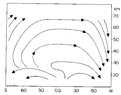
Figure 3.4 Schematic streamlines of the Lagrangian-mean circulation during solstice season (summer on the left, winter on the right). From Dunkerton [1978].
At all levels in the extratropics, but especially in the lowest few kilometres of the stratosphere, nearly isentropic outward transport and mixing of dry tropical air combines with subsidence of moister air. Nearly isentropic transport and mixing are also suggested by radioactive isotopes [Newell, 1963], laminae of high- and low-ozone air [Dobson, 1973], stratospheric aerosol observations [Trepte et al., 1993, Hitchman et al., 1994] and temperature anomalies associated with aerosol plumes [Newell, 1970]. These data suggest that it is rapid isentropic mixing that produces the layer of dry air in the lower stratosphere that covers much of the globe. This near-global minimum in the lower part of the stratosphere (below 20 km or so) is also observed in SAGE II water vapour data [Chiou et al., 1997]. Tuck et al. [1997] have also noted that the meridional mixing process above the tropical tropopause "recirculates" mid-latitude air with higher water vapour concentrations back into the tropical lower stratosphere in this layer.
A useful concept in describing distributions of trace constituents in the stratosphere is the "age of air" [Hall and Plumb, 1994]. In this view, each air parcel is composed of fluid elements that followed different paths to that point, each path with different photochemical exposure histories. The water vapour mixing ratio of the air parcel is determined by the combination of those fluid elements. Thus, the moist air in the upper stratosphere has a high mean age [Hall and Plumb, 1994]. The dry layer of the extratropical lower stratosphere (near 400 K; see Figure 3.3) is composed primarily of fluid elements with low mixing ratio that have travelled rapidly out from the tropical tropopause, but also of some fluid elements of high mixing ratio that have travelled all the way to the stratopause and then down at middle and high latitudes.
In addition to the mean meridional circulation, mixing of air by planetary-scale waves is also important in determining some of the details shown in Figure 3.3. Wave mixing varies strongly in latitude, height, and season, with weak mixing in the subtropics in all seasons (hence the tilting of isopleths there), seasonally varying strong mixing in middle latitudes of the winter hemisphere, and weak mixing at the edge region of the polar vortex in winter [Nakamura and Ma, 1997].
(2) Stratospheric photochemistry
Another important mechanism in determining the distribution of stratospheric water vapour is the oxidation of one molecule of methane into roughly two molecules of water [LeTexier et al., 1988; Brasseur and Solomon, 1986]. In addition to H2O, air entering the stratosphere from the troposphere carries ~1.7 ppmv (1990s value) of CH4 [Dlugokencky et al., 1998] and ~0.5 ppmv of H2. In the stratosphere, CH4 and H2 are destroyed by photolysis [e.g., Scholz et al., 1970]. On time scales relevant to the mean distribution of water vapour (months to years), the oxidation of H2 produces one H2O molecule. Oxidation of CH4 is more complicated, and leads to the production of both H2O and H2. The exact amount of these produced is a function of altitude and latitude, but generally results in ~2 water molecules for each methane molecule oxidised [Jones et al., 1986; LeTexier et al., 1988, Dessler et al., 1994; Hurst et al., 1999; Zöger et al., 1999]. The sum 2´ CH4+H2O is, as a consequence, nearly constant except where air is significantly influenced by dehydration, like the polar regions (see below) and where air retains the seasonal cycle of tropopause temperatures (see section 3.2.2).
The lifetimes of CH4 and H2 are similar, more than 100 years in the lower stratosphere, decreasing to a few years at 30 km and a few months at 40 km. Because air in the stratosphere has a mean age of a few years, all of the stratospheric oxidation of CH4 and H2 is occurring in the middle and upper stratosphere. Therefore, air with low values of CH4 or high values of H2O in the lower stratosphere has been transported down from higher altitudes.
(3) Dehydration at the tropical tropopause
There is widespread agreement that nearly all of the air that reaches the stratosphere above the global hygropause originally travelled through the tropical tropopause [Holton et al., 1995] and that the tropopause region acts like a "cold trap", in which air is dehydrated to very low values. Indeed, only in the tropics are tropopause temperatures low enough to dehydrate air to the mixing ratios observed in the stratosphere [Brewer, 1949]. It is also generally agreed that convection, along with the mean meridional circulation mentioned above, plays a role in dehydration, but many important details are unclear. What is known about the effect of these processes on the water vapour distribution is discussed in detail in section 3.3.3. The combination of convection and the mean circulation creates a mean "entry mixing ratio" [H2O]e of air into the tropical lower stratosphere, as discussed in detail in Section 2.5.4.
(4) Polar dehydration
In the polar vortices, temperatures are sometimes low enough in winter for the air to reach saturation, and the water vapour mixing ratio is lowered by dehydration [Kelly et al., 1989, Kelly et al., 1990]. Such dehydration is strong enough in the southern polar vortex, even though it is only seasonal (between late May and mid-October), to affect the annual mean there (Figure 3.3). Below about 400 K in spring and early summer, dehydration can affect mid-latitudes (see Section 3.3.1), but has little influence on the rest of the stratosphere [Mote, 1995, Rosenlof et al., 1997]. While dehydration has been observed in the Arctic [e.g., Kelly et al., 1990], it occurs much less frequently owing to the Arctic’s warmer temperatures. Consequently, significant decreases of vortex-averaged water vapour have not yet occurred in the Arctic. The poleward decrease seen in Figure 3.3 may result from high values over the northern mid-latitude monsoon rather than from polar dehydration.
(5) Tropospheric leakage to the extratropics
Air in the mid-latitude lower stratosphere below the altitude of the tropical tropopause has considerably higher water vapour mixing ratios than air in the tropical stratosphere (Figure 3.3), and must have leaked from the troposphere without passing the tropical tropopause cold trap [Brewer, 1949; Dessler et al., 1995]. This leakage occurs through two primary pathways, as we discuss in the next paragraph. However, because of the subsidence at these latitudes (Figure 3.4), very little of this air influences the stratosphere above about 380 K. The Southern Hemisphere lower stratosphere between the tropopause and the 380 K potential temperature surface is slightly drier than the northern hemisphere, partly because of moistening by the vigorous northern monsoon [e.g., Stone et al., 2000].
The moist air observed must have reached the lowermost stratosphere along one of two paths: (A) vertically from the extratropical troposphere, or (B) quasi-isentropically from the tropical troposphere through the subtropical gap. Many observational studies [Murgatroyd, 1965; Dobson, 1973; Ray et al., 1999] showed that entry through path B is probably occurring. Evidence for the convective injection path has also been found (e.g., Roach [1966], Johnston and Solomon [1979], Poulida et al. [1996]), but convection rarely reaches 2 km above the local tropopause.
Quasi-isentropic exchange (path B) occurs when synoptic events create "tropopause folds" in the subtropics [Reed and Danielsen, 1959] that significantly deform the tropopause structure and eventually deposit stratospheric air into the troposphere, and vice versa. One possible mechanism is advection by low-latitude troughs [e.g., Mote et al., 1994; Mecikalski and Tripoli, 1998; Kiladis, 1998]. Chen [1995] noted that this exchange is restricted above 340 K in the winter hemisphere, and that the permeable summer subtropical barrier is due to the monsoon circulation in each hemisphere: the Asian and Mexican monsoons in northern summer [e.g., Dunkerton, 1995], and the Australian and South American monsoons in southern summer. Aircraft directly inject water vapour into the lowermost stratosphere [Hoinka et al., 1993, Gettelman and Baughcum, 1999], but model simulations [Danilin et al., 1998] suggest that this will have a negligible impact on the abundance of water vapour in this region.
Concluding remarks about the annual mean
In summary, the annual mean distribution of water vapour illustrated in Figure 3.3 can be understood broadly as a balance of the above processes. However, a fuller understanding of water vapour, even in the annual mean sense, requires considering the seasonal variations in the mechanisms that influence it. We return to this subject in section 3.3.1.
A useful quantity in the total hydrogen budget of the stratosphere is the mean entry mixing ratio, [H2O]e, (see section 2.5.4). [H2O]e is, in principle, an aggregate result of the various conditions under which air enters the stratosphere (see point 3 above, and section 3.3.3), but because these conditions are not uniform in space or time, [H2O]e cannot be calculated directly from observed saturation mixing ratios at the tropical tropopause. Instead, it is generally estimated by sampling the methane and water vapour content of air some distance from the tropopause. Table 2.5 presented estimates of [H2O]e, with annual mean values for the 1990's ranging from 3.0 to 4.1, and a mean value of 3.7 ppmv. For this range of saturation mixing ratios, the range of temperatures is approximately 2° C. The differences between estimates of [H2O]e shown in Table 2.5 are consistent with the instrumental biases discussed in section 2.6.1.
3.2.2 Upper Troposphere
In the troposphere, water vapour amounts are strongly modulated by thermodynamic constraints, and mixing ratios decrease by several orders of magnitude from the surface to the tropopause. Thus, relative humidity is preferable to absolute humidity. Examining and understanding upper tropospheric moisture. However, since tropospheric humidity exhibits strong seasonal and interannual variations, the long-term mean distribution is discussed only briefly. Section 3.3.2 will follow with a more thorough examination of tropospheric vapour in the context of the seasonal cycle.
For an overview of the long-term mean, we utilise data from HIRS (Figure 3.5). A broad band of high relative humidity is clearly visible extending across the tropics, even in the long-term mean. This band possesses three prominent maxima: over the maritime continent near 90° E, over South America around 60° W and over tropical west and central Africa near the Greenwich meridian. Similar patterns are observed with column water vapour measurements from SAGE II [Chiou et al, 1997]. The tropical maxima are associated with the ascending branches of the three tropical monsoon systems: the African Monsoon over central Africa, the Austral-Asian monsoon over the maritime continent, and the South American monsoon over the Amazon. These patterns are consistent with the Walker cell [Bjerknes, 1969] patterns of convective uplift of air with high moisture from below, and downwelling regions of low moisture from above. The maxima also coincide with areas of more frequent sub-visible cirrus clouds, as observed by Wang et al. [1996].
Minima in upper tropospheric humidity are found in the subtropics, also clearly illustrated in Figure 3.5. These minima are not symmetrical, and vary significantly with season. The most persistent, and therefore most prominent in the annual mean, are those straddling the equator over the east Pacific. Dynamically, these can be accounted for as descending branches of a steady circulation forced by a tropical atmospheric heat source located in the deep tropics of the Indo-Pacific region where abundant latent heat release is known to occur [Gill, 1980]. Poleward of the subtropics, the upper tropospheric humidity increases with latitude. This gradient reflects decreasing temperatures at higher latitudes, rather than higher mixing ratios, and results mainly from the properties of meridional mixing as discussed in Section 3.3.2. The modest zonal asymmetries that occur are best understood seasonally and will also be discussed in Section 3.3.2.
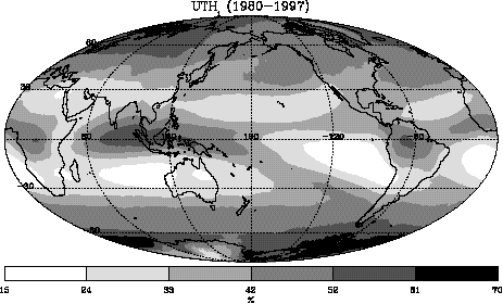
Figure 3.5 Annual mean Upper Tropospheric Humidity over ice (UTHi) averaged for 1980-1987 from HIRS instruments, in percent.