2.6 Summary of comparisons
One goal of this assessment is to determine whether measurements
from a variety of platforms and instrumental techniques are comparable.
It can be seen from the discussion of specific instrument comparisons
presented in this chapter, that there is significant variability
among instruments even when sampling similar conditions. Some
types of comparisons are difficult due to fundamental differences
in types of measurements, as noted in the discussion of measurements
of upper tropospheric humidity from satellite and in situ measurements. Sufficient numbers of coincidences may improve
the statistics in comparing disparate instrumental techniques
where spatial resolution is important. However, in the variety
of comparisons presented, fairly small sample sizes are considered.
Therefore, many of the differences presented are not statistically
significant. This is demonstrated by comparing the absolute values
of the mean difference and RMS difference as plotted on several
other plots in this chapter. In Figure 2.28, the RMS difference
is much larger than the absolute value of the mean difference.
This indicates that random errors are a large part of the measured
instrumental differences. Such random errors may be due to geophysical
variability (none of measurements are exactly coincident in time
or space) or to instrumental noise.
However, even though many of the differences noted are within
stated instrumental errors, certain biases between specific instruments
do appear. One difficulty in assessing the magnitude of those
biases is that a complete set of comparisons does not exist. Thus,
a question to consider is whether one instrument can be used as
a transfer standard to assess the relationship between two different
instruments. This may be possible to do with the lower stratospheric
measurements. The geophysical and sampling issues overwhelm the
tropospheric measurements, and therefore make it a much more difficult
problem.
Of the sensors compared in this chapter, only the frostpoint instruments
have been used extensively both in the troposphere and stratosphere.
For this reason, the summary given below is divided into tropospheric
and stratospheric sections.
2.6.1 Stratospheric comparisons
All the measurement comparisons discussed in this chapter are
summarised in this section based on percentage differences. Any
direct comparisons given in terms of mixing ratio differences
have been converted to percent differences for the purposes of
this section.
In many cases, differences are consistent when comparing across
instruments. Since direct comparisons do not exist between all
instruments, a third instrument was used as a transfer standard
to determine the entire set of relationships between instruments.
In some cases, this technique works well. One good example is
demonstrated using the Harvard Lyman-a, NOAA-AL Lyman-a and JPL TDL airborne instruments discussed in section 2.2. The
NOAA-AL-Harvard comparisons indicate a difference of ~15% with the Harvard
instrument reading larger values. The NOAA-AL-JPL comparisons indicate a difference of ~16% with the JPL TDL
instrument larger. From this, one would derive a JPL-Harvard difference of 1%, with the JPL TDL measurements larger.
The POLARIS comparisons actually indicate a JPL-Harvard difference of 1% with the opposite sign. However, considering
data scatter, the JPL-Harvard difference is essentially zero at cruise altitude, which
would also be deduced using the NOAA-AL Lyman-a as a transfer standard. In other cases, using an third instrument
as a transfer standard does not work as well. One such example
uses the NOAA-CMDL frostpoint, the MLS, and the HALOE instrument.
In the 60 to 100 hPa layer, MLS differs from HALOE by ~5%, with
HALOE larger. The NOAA-CMDL differs from MLS by ~3%, with NOAA-CMDL
larger, leading one to conclude that the NOAA-CMDL instrument
would read ~2% less than HALOE in this layer. However, the direct
comparison between the HALOE and NOAA-CMDL instruments shows NAOA-CMDL
12% greater than HALOE. Because of these differences, both the
direct comparisons and ranges deduced using a third instrument
as a transfer standard will be presented.
One problem in consistency using an instrument as a transfer standard
is that it is possible there are instrumental errors that change
with time. This could be due to instrument degradation, or changes
in atmospheric conditions that affect remote sensing retrievals,
such as aerosol loading, temperature, or interfering gas corrections.
These types of problems (aerosol in particular) likely affect
the HALOE and SAGE II retrievals. Based on comparisons with MLS,
it appears that HALOE problems related to aerosols are much lessened
by 1993. This is fortunate, in that HALOE comparisons are possible
with most of the stratospheric measurements. For this reason,
it will be considered the baseline, and all other instruments
compared with it. In some cases, there are gradients in the percentage
differences throughout the altitude range (HALOE - NOAA-CMDL comparisons shown in Figure 2.21 are one such example). These
gradients will be averaged over to give a single value for each
table. Because the satellite measurements are reported to be less
accurate below ~100 hPa, all comparisons will be presented above
that level. The layer from 60-100 hPa contains the best overlap
of satellite- and balloon-borne measurements. Layers from 10-50 hPa,
and 1-10 hPa are also considered. By necessity, the in situ aircraft instruments will not be included in these comparisons.
Tables 2.5-2.7 show the direct HALOE and indirect comparisons
deduced from the information presented in this chapter. The indirect
comparisons are presented to show the range possible from the
full set of measurements considered. These are constructed as
described at the beginning of this section. Figure 2.72 summarises
the range of measurements for three pressure layers. The mean
values are plotted as symbols, and the range bars map out the
extremes from the indirect comparisons. A small range does not
necessarily translate into a small uncertainty for the estimate.
It may mean that the comparisons are all consistent, or it may
simply denote a dearth of indirect comparisons. In the cases of
POAM III and SAGE II, no indirect comparisons were available,
therefore, the range given is the internal sunrise/sunset difference
deduced for each instrument.
In the 1-10 hPa layer (Table 2.5, top panel of Figure 2.72), 11
instruments are considered. Coincident comparisons with HALOE
were possible with all the instruments except SAGE II. For SAGE
II, climatological comparisons were included. All instruments
are remote sounders, from satellite, high altitude balloon, space
shuttle, and ground based platforms. At this level, aerosol contamination
problems for the solar occultation instruments should be minimal,
and geophysical variability should also be low, making this layer
ideal for these sorts of comparisons. The absolute range of both
direct and indirect comparisons with HALOE is -5% to +17%. The mean is +5% and the median is +6%. The mean comparisons
(symbols in Figure 2.72) of 9 of the 11 instruments cluster between
0% and 10% greater than HALOE. All instruments considered for
the 1-10 hPa layer agree within their stated levels of accuracy.
In the 10-50 hPa layer (Table 2.6, middle panel of Figure 2.72),
13 instruments are considered. Only climatological comparisons
were possible between HALOE and SAGE II, and only indirect comparisons
using other instruments transfer standards were possible for MIPAS.
This layer allows comparisons between satellite and balloon-borne
remote sounders and in situ balloon-borne instruments. The range of both direct and indirect
comparisons with HALOE is -30 % to +27 %. However, this wide range is a consequence of a
large range in the HALOE-LMD frostpoint comparison. If the LMD frostpoint comparisons are
neglected, the range is reduced to -8 % to +16 %. The mean of the comparisons in this layer is +3%,
and the median is +4%. The mean comparisons of 11 of the 13 instruments
fall between -2% and +8%. On average, the instruments considered for the 10-50 hPa
layer also agree within their stated levels of accuracy.
The 60-100 hPa layer (Table 2.7, bottom panel of Figure 2.72)
has the largest number (15) of instruments and measurement techniques
of the 3 layers discussed here. The range of both direct and indirect
comparisons with HALOE is large, from -15% to +42%, with the range of mean comparisons (symbols plotted)
from -9% to +20%. The mean of the comparisons is +6.5%, the median is
+6%, and 11 of the 15 instruments fall into the range -1% to +14%. The two lowest instruments are satellite sensors,
and the two highest are aircraft borne in situ instruments. The balloon-borne in situ and remote sensor measurements cluster near the mean. In this
layer, geophysical variability is larger, thereby making close
coincidences for comparisons more important. A greater number
of measurement techniques are used here, however accuracies quoted
in Chapter 1 do not indicate that should be a problem. Although
the bulk of the measurements at this level do agree to within
stated accuracies, the low satellite and high in situ aircraft measurements do not. Similar differences are also present
in the derived quantity [H2O]e (see Table 2.4), which should minimise sampling mismatch problems.
Thus, it appears that the differences noted here are real. The
differences between instruments occupying the extreme positions
exceed what would be expected based on the uncertainties given
in Chapter 1.
Table 2.5. Summary of the relationship for measurements of water vapour above
10 hPa and below 1 hPa. Percentages reflect differences from HALOE
measurements. The first column shows direct comparisons with HALOE.
The second column shows a deduced relationship with HALOE using
the instrument in the previous column as a transfer standard..
|
Direct Comparisons with HALOE
|
Indirect Comparisons with HALOE
using a transfer instrument
|
|
HALOE +0%
|
|
|
MLS -5%
|
ATMOS +5%
MAS -2%
FIRS-2 0%
WVMS -3%
|
|
SAGE II (SR) +9%
(SS) +3%
(climatological comparisons)
|
No indirect comparisons considered for climatological comparisons.
|
|
POAM III (NH,SR) -5%
(SH,SS) +7%
|
No indirect comparisons available for this assessment.
|
|
ILAS (SH,SS) +8%
(NH,SR) +12%
|
MkIV +16%
FIRS-2 +17%
(indirect ILAS comparisons valid for NH)
|
|
ATMOS +3%
|
MLS -2%
MAS +6%
MkIV +3%
|
|
MAS +5%
|
MLS -2%
ATMOS +9%
WVMS +8%
|
|
MkIV +10%
|
ILAS +14%
ATMOS +10%
FIRS-2 +12%
|
|
FIRS-2 +5%
|
MLS -5%
ILAS +10%
MkIV +3%
|
|
WVMS +6%
|
MLS +9%
ATMOS +9%
MAS +3%
|
|
WASPAM +12%
10% in 1994, 14% in 1998 absolute
range from 9% to 17%
|
No indirect comparisons available for this assessment.
|
Table 2.6. Summary of the relationship for measurements of water vapour between
10 and 50 hPa. Percentages reflect differences from HALOE measurements.
The first column shows direct comparisons with HALOE. The second
column shows a deduced relationship with HALOE using the instrument
in the previous column as a transfer standard. MIPAS had no direct
comparison with HALOE available for this assessment, and is only
included in the second column.
|
Direct Comparisons with HALOE
|
Indirect Comparisons with HALOE
using a transfer instrument
|
|
HALOE +0%
|
|
|
MLS -8%
|
ATMOS +5%
MAS +1%
FIRS-2 -1%
CMDL -11%
LMD balloon (frostpoint) +12%
|
|
SAGE II (SR) +6%
(SS) +2%
(climatological comparisons)
|
No indirect comparisons considered for climatological comparisons.
|
|
POAM III (NH,SR) -8%
(SH,SS) +8%
|
No indirect comparisons available for this assessment.
|
|
ILAS (SH,SS) -1%
(NH,SR) +5%
|
MkIV +3%
FIRS-2 +7%
MIPAS +11%
FISH +15%
LMD balloon (frostpoint) +17%
(indirect ILAS comparisons valid for NH)
|
|
ATMOS +6%
|
MLS -7%
MAS -4%
MkIV +6%
|
|
MAS +4%
|
MLS -5%
ATMOS +14%
|
|
MkIV +5%
|
ILAS +10%
ATMOS +5%
FIRS-2 +0%
|
|
FIRS-2 +4%
|
MLS -3%
ILAS +9%
MkIV +9%
|
|
FISH Lyman-alpha +6%
|
ILAS +16%
LMD balloon (frostpoint) +1%
|
|
NOAA CMDL (frostpoint) -5%
|
MLS -2%
|
|
LMD balloon (frostpoint)
(tropics) +15%
(Sweden) -10%
|
MLS -30% to -5%
ILAS +2% to +27%
MIPAS -7% to +19%
FISH -5% to +20%
|
Table 2.7. Summary of the relationship for measurements of water vapour between
60 and 100 hPa. Percentages reflect differences from HALOE measurements.
The first column shows direct comparisons with HALOE. The second
column shows a deduced relationship with HALOE using the instrument
in the previous column as a transfer standard. Italicized instruments
(JPL TDL and MIPAS) in the second column have no direct comparison
with HALOE available for this assessment.
|
Direct Comparisons with HALOE
|
Indirect Comparisons with HALOE
using a transfer instrument
|
|
HALOE +0%
|
|
|
MLS -5%
|
ATMOS +8%
FIRS-2 +10%
HARV +15%
CMDL -2%
LMD balloon (frostpoint) +5%
|
|
SAGE II (SR) -4%
(SS) -14%
(climatological comparisons)
|
No indirect comparisons considered for climatological comparisons.
|
|
POAM III (NH,SR) -2%
(SH,SS) +5%
|
No indirect comparisons available for this assessment.
|
|
ILAS (SH,SS) ~0%
(NH,SR) +3%
|
MkIV +6%
FIRS-2 +5%
MIPAS -1%
FISH -2%
(indirect ILAS comparisons valid for NH)
|
|
ATMOS +5%
|
MLS -8%
MkIV +3%
AL +3%
HARV +18%
|
|
MKIV +13%
|
ILAS +10%
ATMOS +15%
FIRS-2 +13%
HARV +20%
JPL TDL +15%
|
|
FIRS-2 +5%
|
MLS -10%
ILAS +7%
MkIV +5%
HARV +21%
JPL TDL +21%
|
|
NOAA AL Lyman-alpha (AL) +8%
|
ATMOS +10%
HARV +23%
CMDL -12%
JPL TDL +23%
|
|
Harvard Lyman-alpha (HARV) +20%
|
MLS +0%
ATMOS +7%
MkIV +15%
FIRS-2 +4%
AL +5%
CMDL -10%
JPL TDL +21%
|
|
FISH Lyman-alpha +8%
|
ILAS +13%
LMD Balloon (frostpoint) +3%
|
|
NOAA CMDL (frostpoint) +12%
|
MLS +15%
AL +32%
HARV +42%
|
|
LMD balloon (frostpoint)
(tropics) +15%
(Sweden) -5%
|
MLS -15% to +5%
MIPAS -1% to +19%
FISH +0% to +20%
|
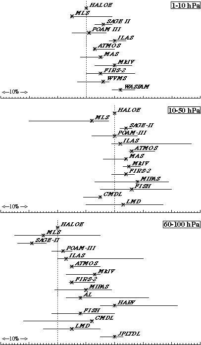
Figure 2.72. Summary of the relationship between stratospheric measurements
assessed in this report for 3 altitude ranges. The symbols give
the direct percentage difference from HALOE, and the horizontal
lines show the range of the indirect comparisons presented in
Tables 2.5-2.7. Each tick mark is 1%, and the placement for HALOE is indicated
by the dotted line. Where no direct comparison was available,
the symbols give the average of the indirect comparisons.
At levels above 50 hPa, overall agreement between the sensors
compared is quite good. The range of the direct comparisons with
HALOE is less than 20%, with a clustering of nearly all the instruments
within a range of 10% and instruments agreeing to within their
stated levels of uncertainty. In the lowest layer considered,
the agreement is still good in general, although the direct comparison
extremes cover a range of 30% and most of the instruments compared
fall within a 15% range.
From this set of comparisons, it appears that the infrared instruments
agree well with each other and with the balloon-borne in situ instruments. The MLS stratospheric water vapour is biased low
relative to the other instruments at all levels. In the 10-50 hPa
layer, the two frostpoint instruments considered tend to be biased
slightly low relative to most of the other measurements. This
is not true in the 60-100 hPa layer, where both frostpoint instruments
fall in the middle of the cluster of comparisons. The one stratospheric
aircraft TDL instrument was not only biased larger than the other
instruments at its cruise flight level, but there was a pressure
dependence to its difference with the coincident Lyman-a measurements. Three Lyman-a instruments were considered, and there was not a consistent bias
associated with the three as a whole. However, one of the instruments
was biased high relative to the others in flight, but agreed within
stated uncertainties when compared with both a frostpoint and
another Lyman-a instrument under controlled laboratory conditions. This indicates
that the fundamental in situ techniques are well understood, but that implementations of those
techniques on airborne platforms are not. The reason for the larger
spread in flight conditions is not understood; the problem deserves
further attention.
Three of the solar occultation satellite instruments (SAGE II,
ILAS and POAM III) show significant sunrise-sunset differences
that deserve further examination. SAGE II is biased low in the
60-100 hPa layer, but there are likely aerosol contamination problems
with its lower stratosphere retrievals associated with the decay
of aerosol from the eruption of El Chichón. Although useful for
deducing certain aspects of atmospheric behaviour, one should
ensure that the research application fits the capabilities of
the SAGE II data set. Filtering to avoid regions of high aerosols
is likely needed. A new retrieval has been recently released,
but it remains to be seen what improvements result. It should
be noted that such an aerosol contamination problem is not unique
to the SAGE II data. As described in section 2.4.2, during its
first year of operation, HALOE measurements in the tropics are
also likely affected by Mt. Pinatubo aerosols.
In spite of the differences detailed above, it appears that the
agreement between different instruments measuring stratospheric
water vapour has improved significantly over the past 15 years.
Results presented in Albritton and Zander [1985] (see their Figure C-7) show a range of 50-60% between
different balloon-borne instruments in an organised comparison,
with no clear apparent clustering of measurements. In the present
set of comparisons, the majority of the instruments cluster within
a 10% range at all levels, with the extremes of the indirect comparisons
of clustered instruments separated by ~30%. If the small number
of instruments that fall at the high and low ends of the comparisons
are considered, the extremes of the indirect comparisons are separated
by ~50%. Still, the bulk of the instruments agree well with their
stated errors. This should be considered a vast improvement over
the state of stratospheric water vapour measurements in the early
1980's.
Existing measurements should be adequate for describing the seasonality
of lower stratospheric water vapour, and deducing certain aspects
of stratospheric transport and stratosphere-troposphere exchange.
Yet, even this seemingly good agreement is not sufficient to allow
combining instrumental records to estimate long-term changes in
stratospheric water vapour. Deduced changes presented in section 2.5.5
are on the order of 1%/year. 10% agreement is not sufficient to
allow combination of time series from different instruments; the
biases are still larger than the signal of interest. A long data
set from the same instrument is more valuable than a series of
short data sets from different instruments for long-term change
determinations. Continuing to fly instruments with extensive histories
is important for monitoring the stratosphere for long-term changes
in water vapour.
2.6.2 Upper tropospheric humidity comparisons
Because of the radiative importance of water vapour in the upper
troposphere and the potential for long-term change, an assessment
of the quality of the data in this region of the atmosphere is
an essential part of this chapter. In terms of available data
for describing the distribution and understanding the processes
that control water vapour in the upper troposphere, the data set
from the HIRS sensor on TOVS is the most comprehensive in geographic
coverage and length of record. The world-wide radiosonde network
has provided tropospheric humidity measurements since the 1940's.
The length of record and global coverage suggest that radiosondes
have the potential for providing data for addressing questions
about water vapour behaviour, and could be an important tool for
evaluating other measurement techniques. However, the radiosonde
network humidity sensor performance tends to be of poor quality
at cold temperatures and low pressures (see section 1.1.4), which
are precisely the conditions experienced in the upper troposphere.
Additionally, as noted in section 1.1.4, there have been numerous
changes in instrumentation over the existing data record, this
complicates analysis of such data for long-term changes. However,
because of their relatively low cost, operational radiosondes
have been, and likely will continue to be, used for validation
purposes of upper tropospheric humidity. The recent improvement
of radiosonde humidity sensors holds some promise for obtaining
better data from these operational instruments. Comparisons presented
in this chapter (section 2.2.3) between the widely used Vaisala
Humicap A sensor and the NOAA-CMDL frostpoint instrument show, for example,
that at temperatures of ?60oC the reported humidity from the radiosonde is only one half of
the frostpoint instrument value. From this type of comparison,
a correction algorithm to improve the quality of the upper tropospheric
radiosonde data was developed. However, application of this correction
to the archived Vaisala radiosonde data set for the period 1991-1994
for comparison with the MLS upper tropospheric water vapour product
yielded inconsistent results that are not currently understood
(see section 2.3.2). Appropriately calibrating the radiosonde
humidity element for the temperature conditions of the troposphere
can improve the accuracy of the measurements (section 2.2.3).
Such calibrations are being implemented in newer radiosonde models.
In addition to radiosondes, several other non-satellite systems
were compared primarily with a view toward their value in evaluating
the TOVS and MLS upper tropospheric water vapour products, but
also for their potential as new technologies for future measurements.
Both DIAL and Raman LIDAR systems were compared with radiosondes
as well as airborne systems using chilled mirror hygrometers.
The LIDARs gave results in the troposphere within about 10% of
the correlative measurements, suggesting that such systems can
accurately measure water vapour, and that if deployed in sufficient
numbers could provide profile data for satellite validation.
Commercial aircraft provide a platform from which upper tropospheric
water vapour data can be obtained on a regular basis in heavily
used flight corridors. The MOZAIC program currently provides such
data using a specially calibrated sensor similar to the Vaisala
radiosonde Humicap-H. This set also provides potential satellite correlative data.
Comparisons of the MOZAIC sensor with airborne frostpoint and
Lyman-a hygrometers as part of designed validation experiments show that
the MOZAIC measurements are accurate to about 10% in mixing ratio
for flight altitudes in the upper troposphere.
From the direct water vapour measurements summarised above, comparisons
were carried out with the MLS and TOVS satellite observations.
The high variability of water vapour in the upper troposphere
leaves significant ambiguity in the conclusions from these comparisons.
At present, it must be concluded that the direct measurements
of UTH do not provide a strong constraint on the satellite measurements
of UTH. At the two highest MLS retrieved levels (147 hPa and 215 hPa)
the biases are smaller (about 10%) than those at the lower two
altitudes where all of the comparisons suggest a dry bias of MLS.
Published comparisons of radiosonde humidities with TOVS data
show that the radiosondes indicate substantially smaller humidity
values. A recent comparison of a fairly small number of properly
calibrated radiosonde sensors with TOVS UTH showed only small
biases. In the TOVS comparisons with MOZAIC, it was found that
at higher latitudes, the satellite weighting function peaked at
a different altitude than the aircraft observations. This results
in biases between the derived humidities from the two techniques.
For comparisons at low humidities, the MOZAIC measurements are
smaller than are those from TOVS. However, the bias derived is
not statistically significant. An important issue is that the
variability of the means of the smaller MOZAIC data set differs
significantly from that of the much larger TOVS data set. This
indicates that the smaller MOZAIC data set is not adequately capturing
the true atmospheric variability, and thus statistical comparisons
between the disparate data may not be meaningful.
Comparisons of SAGE II integrated water vapour between 200-500 hPa
with integrated TOVS data suggest that SAGE II sampling is insufficient
to properly characterise the full variability of upper tropospheric
water vapour. Although TOVS samples much more frequently than
MLS, the two instruments have similar sampling volumes. These
two instruments provided the best opportunity for comparison of
satellite UTH. At the 316 hPa level (near the peak of the TOVS-HIRS
channel 12 weighting function), the TOVS and MLS give similar
results. At very low and at very high values of UTH, MLS averages
are biased low relative to TOVS. This is likely due to the small
number of coincidences. In the mid-range of UTH there is virtually
no bias. Overall these two systems that use very different techniques
appear to produce comparable results on monthly averaged time
scales.
2.6.3 Conclusions and recommendations
Over 25 instruments representing several techniques were assessed
for the quality of the data that they produce. More conclusive
results about data quality could be drawn from the stratospheric
comparisons than those in the upper troposphere. In some ways
this reflects the fact that in the upper troposphere water is
more dynamic and variable, making comparisons more difficult.
It also appears, however, that greater emphasis has been placed
on, and attention paid to, developing and validating stratospheric
water vapour observations. For both the stratosphere and troposphere
there is no single technique or instrument platform that is recognised
as a standard to which other techniques should be compared, and
thus comparisons were made relative to one another.
In the stratosphere, a reasonable degree of consistency was found
among measurements made from near the tropopause up to 50 km (~1 hPa).
The majority of the instruments considered clustered within a
10% range, although direct comparisons among other individual
instruments showed larger differences, however, with some of these
exceeding 30%, and indirect intercomparisons reached 50%. For
differences smaller than about 10%, the quality of comparisons
makes it difficult to determine the cause of the differences since
they may be related to factors such as coincidence of measurements
that are affected by atmospheric variability. However, even much
larger differences, that indeed appear to be real, such as those
between MLS and the Harvard Lyman-a instrument, do not seem to have causes that were revealed through
this assessment process.
There is only one stratospheric water vapour data set of 20 years
duration that has a nearly continuous time series available for
determination of long-term changes. There are, however, a number
of sets that have sampled periodically over a long period and
several time series of intermediate length (8-15 years) that can
be used for evaluating stratospheric changes. Although not definitive,
these observations are consistent in suggesting that water vapour
has increased at about 1%/year over the past 50 years. The record
also suggests that this increase has not been uniform but has
varied over this period.
In the upper troposphere the TOVS data set is the most extensive
in length of record and geographic coverage, and is the only one
capable of answering many of the scientific questions about water
vapour in this region of the atmosphere. It was therefore the
data set that was the focus of the UT data quality assessment.
The tropospheric MLS sensor provided the best data set for comparison
with TOVS and only small biases were found between them. Comparisons
between TOVS and MLS and direct water vapour measurements from
radiosondes and aircraft did not provide strong constraints on
the performance of the satellite sensors. In part this was due
to the shortcomings in the direct measurements, particularly the
radiosondes. However, there are also difficulties with making
comparisons in an inhomogeneous atmosphere when instruments have
very different spatial coverage and altitude resolution. The assessment
of the TOVS data did not reveal any major inconsistencies in this
data set that would preclude its use in describing the behaviour
of upper tropospheric humidity.
Several recommendations that can be made from this evaluation
of data quality include:
- Further studies, including well designed intercomparison experiments
and laboratory work, are required to quantify and understand the
differences between stratospheric water vapour sensors, particularly
in situ instruments that are required for providing high altitude resolution
data for processes of water vapour transport between the troposphere
and stratosphere.
- Strong validation programs including correlative measurements
need to be a part of water vapour satellite measurement efforts.
In the upper troposphere such validation has not been a part of
the measurement program. Improvement of radiosonde observations
of water vapour and wider use of LIDAR would aid in such validation.
- Greater attention needs to be paid to the continuity of measurements
for determination of long-term changes in both the stratosphere
and upper troposphere including overlap of satellite measurements.
In particular, instruments with a history of high quality measurements
should continue to operate in order to monitor long-term changes
in stratospheric water vapour.