2.5 Comparisons of derived quantities
2.5.1 SAGE II and HALOE annual averages
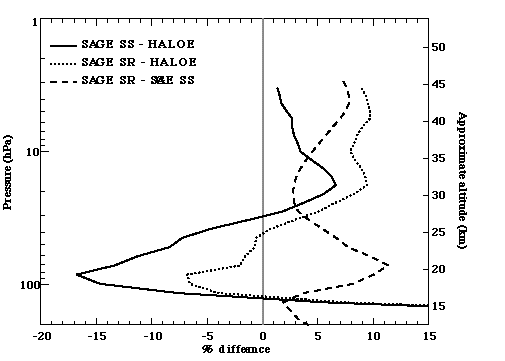
Most of the comparisons shown in this chapter have considered measurement pairs nearly coincident in space and time. However, climatological comparisons are another means of assessing data quality and consistency between different data sets. Although the time period for which SAGE II water vapour data are available does not overlap with that for which HALOE is available, it is possible to compare annual averages. For one such comparison, SAGE II data were averaged from 1987 through 1990, and HALOE data were averaged from 1993 through 1999. The first year of each data set was left out of the averages to avoid periods with the heaviest aerosol. Heavy aerosol loading can negatively impact both retrievals. However, doing the same comparison including 1986 and 1992 in the SAGE II and HALOE averages respectively makes little difference. In constructing the SAGE II averages, the aerosol extinction filtering criteria given in Rind et al. [1993], where data is considered good if the 1.02 mm extinction is less than 5¥10-4/km, was also used. Comparisons were done for both sunrise and sunset occultations. Differences were computed between 50ºN and 50ºS, where coverage for both instruments is most complete. The average percent difference, shown in Figure 2.60, is found to be a function of altitude, with SAGE II sunset measurements up to 15% smaller than HALOE below 25 km, and SAGE II sunset measurements larger than HALOE by up to 7% above 28 km. There is also a difference between SAGE II sunrise and sunset annual means, giving a profile of average of ~5%, with sunrise occultation measurements larger. There is vertical structure to this difference too, with maximum values near 20 km.
Figure 2.60 Percent differences between SAGE II and HALOE annual averages. The profile shown is the average difference between 50ºN and 50ºS. Differences presented are (SAGE II-HALOE)/average for the SAGE II sunset data (solid line), sunrise data (dotted line) and also for the SAGE II sunrise-sunset difference (dashed line).
For a second annual average comparison, eight years of HALOE data (1991-1999) and four years of SAGE II data (1987-1990) were binned according to equivalent latitude (based on potential vorticity) in 4º intervals, and on potential temperature (q) levels (420-1300 K) nearest to the UARS standard pressures (six levels per decade of pressure). The HALOE analysis used UKMO-UARS potential vorticity (PV) and HALOE temperatures (based on NCEP analyses at these levels) for the binning calculation, while the SAGE II analysis used NCEP analyses for both PV and temperature. In this case, no aerosol-filtering criterion was used. Figure 2.61 shows the annual averaged HALOE and SAGE II water vapour as a function of equivalent latitude and potential temperature. The SAGE II results from sunset and sunrise occultations are presented separately. Overall features are similar between the three plots, with low mixing ratios near the tropical tropopause, and larger values at higher altitudes and latitudes, a consequence of water vapour production due to methane oxidation. The sunrise-sunset difference with the SAGE II data is apparent, with sunrise results ~0.2-0.4 ppmv larger than sunset. The SAGE II sunset annual mean is similar to that of HALOE at middle latitudes, but ~0.2-0.4 ppmv smaller than HALOE in the tropics. There are differences between HALOE and SAGE II in regards to vertical gradients in the tropics; this is likely the result of aerosol influence on the SAGE II water vapour retrieval discussed in Chapter 1 (Section 1.4.3).
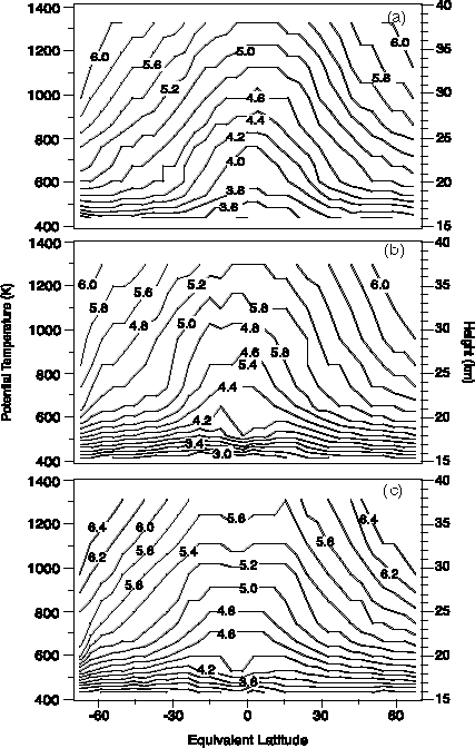
Figure 2.61 Water vapour annual zonal mean derived from the (a) HALOE, (b) SAGE II sunset and (c) SAGE II sunrise data. The zonal mean is derived from binned average on a 4º equivalent latitude grid and potential temperature levels nearest to the UARS standard pressure levels. The values are mixing ratios given in ppmv.
2.5.2 Satellite seasonal climatology comparisons
SAGE II and HALOE
Seasonal climatology comparisons are another way to assess data quality. Here a comparison between HALOE and SAGE II monthly averages in the lower stratosphere is presented. Again eight years of HALOE data (1991-1999) and four years of SAGE II data were binned according to their equivalent latitude, in 4-degree intervals, and potential temperature levels nearest to the UARS standard pressure levels. The climatologies were derived from harmonic fits of the binned averages, following the method described in Randel et al. [1998]. The binning was done as described previously for the annual average HALOE-SAGE II comparison.
Figure 2.62 shows the time series of the monthly means of HALOE and SAGE II sunset data for two equivalent latitude bins (the equator and 40°N) on the 465 K isentropic surface (~19 km), together with the (repeating) seasonal cycle curves derived from the harmonic fits. Only four years of HALOE data are shown (1996-1999), for comparison to the four-year cycle of SAGE II data. The HALOE data exhibit a clear annual cycle in both tropics and middle latitudes. The SAGE II time series at 40°N shows a qualitatively similar seasonal cycle fit as HALOE. However, in the tropics, the seasonal cycle captures only a small component of the overall variance of the SAGE II data, and the fit is very different from that of HALOE. The large and irregular scatter in the tropical SAGE II data, and the negative trend, suggest the possible influence of aerosol artefacts in the SAGE II data, especially in the tropics. With the assumption that the better seasonal fit to the HALOE data gives a more precise representation of the seasonal pattern, it appears that the SAGE II data in the lower stratosphere and above the aerosol layer can provide reasonable seasonal variations at middle latitudes, but not in the tropics. Also shown in Figure 2.62 are time series of monthly mean SAGE II data for the equatorial and 40°N zone on the 375 K isentropic surface and the associated harmonic fit. At the level below the aerosol layer, both in the tropics and at middle latitudes, there is a clear seasonal cycle and reasonable agreement of monthly mean data with the harmonic fit.
The ability of SAGE II to describe the seasonal pattern at this lower level is further illustrated by comparison of the HALOE and SAGE II data on the 375 K potential temperature surface (approximately 120 hPa pressure level), shown in Figure 2.63. Although the time period of the measurements is different for the two data sets, HALOE and SAGE II data show similar seasonal variations with maximum values during Northern Hemisphere summer, and the latitude of the maximum near 30ºN in both. Low values during Southern Hemisphere winter at high Southern latitudes are also apparent in both the HALOE and SAGE II distributions.
ILAS and UARS Reference Atmosphere
The ILAS instrument made measurements at high latitudes and produced eight months (November 1996-June 1997) of stratospheric water vapour data near both the Arctic and Antarctic polar vortex. Although the measurements were only made at narrow latitude bands geographically (varying from 57ºN to 73ºN and from 64ºS to 88ºS), they covered a wide range of dynamic atmosphere due to the steep PV gradient near the vortex edge and the asymmetry of the vortex shape. When the measurements are sorted by the dynamic variable PV (expressed as the equivalent latitude), the ILAS measurements cover approximately from 30 degrees to the pole in equivalent latitude space in both hemispheres. Under these conditions, it is essential to use the equivalent latitude instead of the geographical latitude in the compilation of a climatology, and for comparison with other satellite climatologies. Shown in Figure 2.64 is the ILAS water vapour climatology (computed from Version 4.20 data) and the UARS reference atmosphere (based on 84 months of data, see Randel et al. [1998] for details) for the 72ºS equivalent latitude band. Although the two data sets cover different years, in this cross-section they show consistent climatological features in the stratospheric water vapour. The differences are potentially due to atmospheric interannual variability as well as the uncertainty of the measurements, as discussed in Chapter 1 (Section 1.4.9).
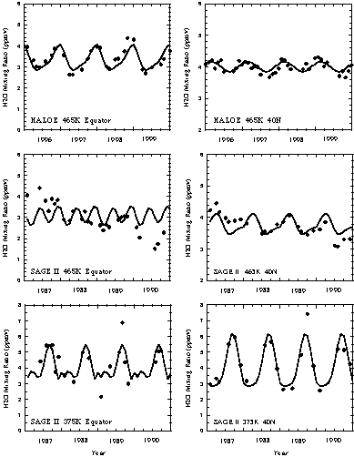
Figure 2.62 Time series of binned monthly average versus the fits for 465 K isentrope HALOE data (upper panels), 465 K isentrope SAGE II sunset data (middle panels) and 375 K SAGE II sunset data (bottom panels). Two latitudinal bins are shown in the figure, equatorial on the left and 40°N on the right.
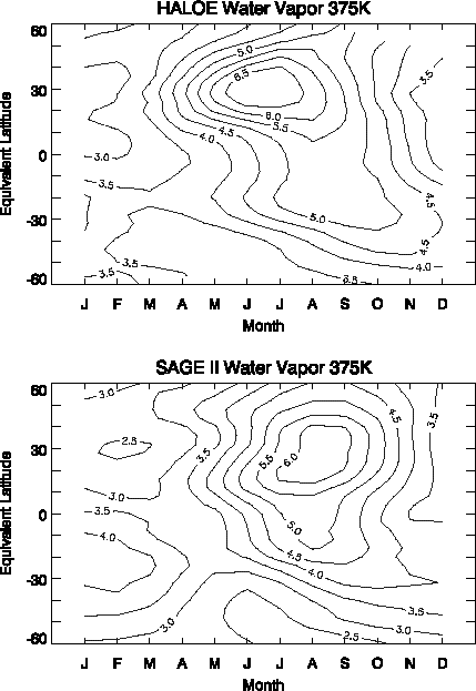
Figure 2.63 Seasonal cycles derived from HALOE and SAGE II (Sunset) data on the 375 K isentrope. Some smoothing has been applied to the SAGE II data. The values are mixing ratios given in ppmv.
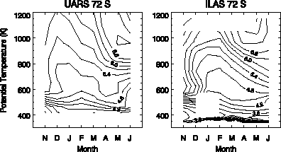
Figure 2.64 Comparison of ILAS water vapour climatology and UARS reference atmosphere. The contours are water vapour monthly zonal mean mixing ratio (in ppmv) calculated in 4 degree equivalent latitude band. Shown in the figure are time:height (month:q) cross-sections for the ILAS measurement period of the year (November to June) for the 72°S latitude band.
2.5.3 Lowermost stratosphere in situ and satellite climatologies
Comparisons of the seasonal cycles derived from SAGE II, MLS upper tropospheric, and ER-2 data are made to assess the measured water vapour variability in this region. The ER-2 data used in this analysis are from the Harvard Lyman-a hygrometer during the Stratospheric Tracers of Atmospheric Transport (STRAT) and Photochemistry of Ozone Loss in the Arctic Region in Summer (POLARIS) missions (1995-1997).
Since the three data sets were taken in different years with different sampling strategies, it is advantageous to compare their climatologies in the dynamically based coordinates of PV and potential temperature [Hoskins, 1991]. PV values are also useful indications of how "deep" the air parcels are in the stratosphere. Using Ertel’s PV, values of 2-3 PVU or greater are associated with stratospheric air [Holton et al., 1995]. PV and q information came from UKMO for the MLS data, from NCEP for the SAGE II data, and from the ER-2 mission data (consisting of measured temperatures and PV from the NASA-Goddard model assimilation) for the aircraft data.
Figure 2.65 gives examples of this comparison for measurements in the lowermost stratosphere and near the extratropical tropopause (PV = 3-4 PVU and 5-6 PVU, q =330 and 350 K). The seasonal cycles in the figure are monthly means computed by binning the data according to their PV (in 1 PVU intervals) and q (in 10 K layers). Included in the calculation were 5 years of SAGE II data (1986-1990), 6 years of MLS data (1991-1997) and 3 years of Harvard Lyman-a data (1995-1997) (with at least 3 data points in each PV-q bin). In cases of comparisons with the Harvard data, it is important to note there is a much smaller number of samples (total ~70 flights) and that the measurements were taken over a narrow longitudinal range (~120°-150°W). The monthly average produced is more likely to be subject to longitudinal variations of the water vapour and the random effect of the sampling.
Typically, the mean values and the variances from MLS are larger than the SAGE II in the wetter seasons on the lower isentropes. This is consistent with the fact that MLS has a 3 km vertical resolution, as compared to the 1 km vertical resolution of SAGE II instrument. Note that water vapour has a steep vertical gradient in this region and MLS results represent the average of a 3 km layer. This needs to be considered in all intercomparisons presented in this section. Another possible factor contributing to the positive MLS-SAGE II difference in the wetter season is that SAGE II data are only for clear sky conditions, while MLS data include cloudy conditions. Harvard Lyman-a data, although agreeing with the satellite seasonal cycle in general, display more variability and tend to have larger water vapour values during the fall season relative to MLS and SAGE II on the lower isentropes. This is likely due to the small sample of the data and the longitudinal variability.
Average differences were computed between monthly means derived from SAGE II, MLS, and Harvard Lyman-a measurements over the annual cycles for the lowermost stratospheric region (2-7 PVU, 330-360 K for SAGE II and Harvard, 330-350 K for MLS). Detailed statistics are given in the caption for Figure 2.65. For the entire PV-q range examined, the average Harvard-SAGE II differences are nearly always positive. The average MLS-SAGE II differences vary nearly monotonically from low to high PV bins, ranging from +26% for 2-3 PVU to -35% at 6-7 PVU. The overall pattern of the MLS-Harvard comparison is similar; varying nearly monotonically from +23.5% for 2-3 PVU to -19.2% for 5-6 PVU. This systematic variation is consistent with the fact that MLS has a 3 km vertical resolution, as compared to the 1 km vertical resolution of SAGE II and the fine resolution (0.1-0.2 km) of Harvard instrument. Since the water vapour mixing ratio has a steep vertical gradient in this region, MLS results, which represent the averages of 3 km thick layers, may show a wet or dry bias in comparison with the SAGE II and Harvard data, depending on the shape and the peak position of the weighting function relative to the nominal pressure of the layer.
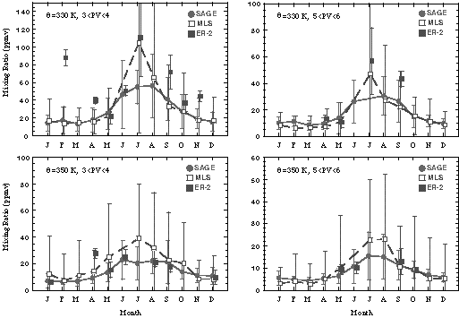
Figure 2.65 Examples of seasonal cycles derived from SAGE II, MLS and ER-2 measurements. Shown in the figure are monthly means in PV-q bins using 1 PVU interval and 10 K q layers. The symbols represent the monthly mean from 5 years of SAGE II data, 6 years of MLS data and 3 years of ER-2 data. The error bars indicate the standard deviation. The four examples are for 330 K, PV=3-4, 5-6 PVU and 350 K, PV=3-4, 5-6 PVU. The average difference of the Harvard-SAGE II monthly means over the annual cycle for all the bins within the PV-q range from 2-7 PVU and 330-360 K is 24%. The average MLS-SAGE II difference (for the 330-350 K range) in the lowest PV bin (2<PV<3 PVU) has the highest positive value (~26%). The difference then decreases with increasing PV value (22% for 3<PV<4, 10% for 4<PV<5, -8% for 5<PV<6 and -35% for 6<PV<7 bins, respectively). The average MLS-Harvard differences (in the 330-350 K range) are similar to the MLS-SAGE II comparison, with differences of ~23.5% for 2<PV<3 PVU, -2.0% for 3<PV<4 PVU, -6.4% for 4<PV<5 PVU, and -19.2% for 5<PV<6 PVU bins respectively.
2.5.4 Entry level [H2O]e and 2¥CH4+H2O
Comparisons between different instruments can be complicated by the fact that air masses with different characteristics occur in close proximity to one another. In some cases discussed in this chapter, other species (N2O and CH4) or dynamical quantities have been used to characterise the air mass prior to doing comparisons. In this section, comparisons of the quantities 2¥CH4+H2O and [H2O]e are presented. [H2O]e, the entry level mixing ratio, is the mass weighted average of the mixing ratios at entry into the stratosphere of all the parcels that make up the sampled region [Hansen and Robinson, 1989]. 2¥CH4+H2O, sometimes referred to by the term "potential water", is considered to be a conservative quantity, assuming the effective yield of H2O from CH4 destruction is 2 [Jones et al., 1986]. Modelling work by LeTexier et al. [1988] indicates a range in the effective yield, with an average near 2, as does a study with an older version of HALOE data than assessed in this document [Remsberg et al., 1996]. Given that the average effective yield is 2, and the common use of [H2O]e in the literature, a compilation of values found in the peer-reviewed literature and computed from data provided for this assessment is presented in this report. If the methane values are assumed to be absent of uncertainties, and there are no long-term changes in either CH4 or H2O, either entry level mixing ratio or potential water can be used to assess relationships between instruments even when no coincidences exist.
Care needs to be taken to ensure that the quantity is calculated away from effects of the seasonal cycle of lower stratospheric water vapour and polar dehydration. Restricting the estimates by using only data from pressure levels between 10 and 4 hPa and methane values greater than 0.5 ppmv filters seasonal and polar dehydration effects from the satellite data. This filtering also avoids regions where the mixing of mesospheric air with stratospheric air exerts significant leverage on the CH4/H2O relationship. However, for in situ aircraft data that does not extend even to 50 hPa, filtering using some measure of the length of time a given parcel has been resident in the stratosphere needs to be employed. N2O, SF6 or CO2 age, and CH4 values have all been used to filter aircraft data [Hurst et al., 1999; Dessler et al., 1994]. Some checks are also required to avoid regions of polar dehydration in the aircraft data. Balloon measurements do not always extend above 10 hPa, so again a species filtering method needs to be used. For most calculations done specifically for this report, a CH4 cut-off of 1.35 ppmv was used for the balloon measurements estimates, similar to that used in Hurst et al. [1999] and Dessler and Kim [1999].
Another point to consider in these comparisons is the time span valid for the entry of air parcels into the stratosphere. This is important, as long-term changes have been noted in both CH4 [Dlugokencky et al., 1994; Etheridge et al., 1998] and water vapour (see Section 2.5.5 and Chapter 3 discussion). In cases where major changes have occurred in the retrievals, only the calculation done for the version of the retrieval discussed in this report is included. The publications cited in the table were chosen to cover the time span of the instruments discussed in this assessment. For some instruments, earlier publications do exist that present these quantities for subsets of the data available for this assessment. In other cases, multiple publications needed to be considered to cover the operating period of a given instrument.
A further item of note is that entry-level water (or residual water) has been estimated three different ways in the published literature. In one case [as in Jones et al., 1986],
[H2O]e =H2O-2¥([CH4]e -CH4)
In this expression, the effective yield of water vapour due to methane destruction is assumed to be 2. This technique will be referred to in Table 2.4 as the average residual water method. A second method [as in Remsberg et al., 1996], uses a least squares regression analysis with simultaneous CH4 and H2O measurements to compute the effective yield coefficient b (slope) and I (intercept). Then, using those estimated coefficients,
[H2O]e = b[CH4]e.
Hansen and Robinson [1989] were the first to use a variation of this method by calculating b for different time periods via a regression analysis and then averaging
[H2O]e=H2O-b¥([CH4]e -CH4).
This will be referred to in Table 2.4 as the slope/intercept method. For both of these methods an assumption must be made about [CH4]e, which for the calculations presented here ranges from 1.6 ppmv (1980's) to 1.72 ppmv (recent observations). These two methods can give different results using exactly the same input data when b differs from -2. (Note: in Dessler and Kim [1999], the range over different years for b is -1.7 to -1.96). Using HALOE data during the period January 1993 until March 2000, and filtering by only considering measurements above 10 hPa with CH4 ranging from 0.5 ppmv to 1.35 ppmv, the regression method gives a value for [H2O]e of 3.5 ppmv and the residual water expression gives a value of 3.6 ppmv. If the exact same latitude/altitude/time filtering used in Dessler and Kim [1999] is employed, the results differ more, with the average residual water method giving [H2O]e=3.6 ppmv, and the slope/intercept method giving [H2O]e=3.8 ppmv. An additional consideration is what levels to average over. The way in which this plays a role is demonstrated by examination of the average vertical profile between 50ºN and 50ºS of HALOE 2¥CH4+H2O plotted in Figure 2.66. Note that between 10 hPa and 1 hPa, 2¥CH4+H2O decreases by ~0.2 ppmv as will any estimate of [H2O]e. A third method to estimate [H2O]e is to average observations of water vapour just above the tropical tropopause. This is the only way to make such an estimate when coincident CH4 measurements are not available, and is used for making the SAGE II estimate given in Table 2.4. Again, HALOE measurements can be used for this calculation to demonstrate how it differs from other methods. Averaging the 100 hPa retrievals from 1993 through 1999 between 20ºS and 20ºN gives a low of 2.7±0.9 ppmv for February, a high of 4.7±0.7 ppmv for August, and a simple annual mean of 3.6±1.0 ppmv. In terms of multi-year means of [H2O]e, the range presented here is 3.5 to 3.8 ppmv. This 0.3 ppmv range does not consider error estimates that come out of the individual methods. This demonstrates that, in addition to the uncertainties calculated due to data scatter, discrepancies with the method of computation introduce additional uncertainties of more than 5%.
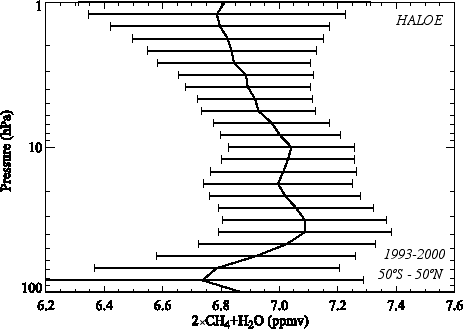
Figure 2.66 Average vertical profile of 2¥CH4+H2O calculated with HALOE data from 1993 to 1999 and 50ºS to 50ºN.
A compilation of potential water and [H2O]e for the instruments discussed in this chapter is presented in Table 2.4. If a published value exists for the current data processing algorithm, it is included in the table; otherwise, an estimate was made with the data provided for this assessment. For the cases computed specifically for this assessment where a methane measurement or estimate was possible, the average residual water method [Jones et al., 1986] was used. This was chosen because improperly filtered polar dehydration or seasonal cycle parcels affects the slope/intercept method more that it does the residual water method. Multiple entries exist for some instruments. These represent either different time periods or different analyses with the same data. For POAM III, a significant difference was found between hemispheres (sunrise versus sunset occultations), so an entry is given for each hemisphere. The entries are roughly ordered by increasing 2¥CH4+H2O. When multiple values exist for an instrument, the average was used to place it in the table. The methane measurement source and [H2O]e calculation technique are stated in the table. In a few cases, only potential water or entry level water was published. To fill in the table, the missing entries were inferred using the stated value of entry level methane. 1s standard deviations are given for calculations done specifically for this report, otherwise the published error estimate is given.
Potential water ranges from 6.0 to 7.5 ppmv, with the lowest value from LIMS (1979), and the highest value from the Harvard Lyman-a instrument (1990's). There is evidence from multiple data sets supporting an increase in stratospheric water vapour over this time period; this will be discussed in detail in section 2.5.5. For the period 1990-2000, the average of all entries are 7.1 ppmv for 2¥CH4+H2O, and 3.7 ppmv for [H2O]e (with 1s standard deviation = 0.25). If one assumes saturation at 100 hPa, that corresponds to an average entry-level temperature of approximately -82.4ºC. The 1990's [H2O]e range of estimates is 3 to 4.1 ppmv, corresponding to a 100 hPa entry-level temperature range of -83.5ºC to -81.8ºC.
Table 2.4. Estimates of water vapour entering the stratosphere ([H2O]e) and potential water (2¥CH4+H2O). Instruments are ordered by increasing potential water.
|
|
|
(ppmv) |
(ppmv) |
period |
[H2O]e |
|
| LIMS | Jones [1986] | ~6.0 | 2.7± 0.35 |
|
Average residual water [CH4]e=1.65 ppmv Data up to 1 hPa |
SAMS |
| Hansen and Robinson [1989] | 6.3 | 3.3± 0.2 |
|
Methane yield (b) calculated for month and latitude bins. [H2O]e calculated using b and [CH4]e=1.6 ppmv Data up to 3 hPa |
||
| SAGE-II | Chiou et al. [1997] |
(5.6 - 6.8 ave=6.2) Inferred using 2¥[CH4]e +[H2O]e |
2.3 - 3.5 (DJF - SON) ave=2.9 |
|
20ºS-20ºN seasonal hygropause average ([CH4]e = 1.65 ppmv) |
None |
| MLS | Calculation for this report | 6.4 ± 0.26 | 3.0 ± 0.27 |
|
Average residual water [CH4]e = 1.7 ppmv |
HALOE coincidences |
| LMD | Engel et al. [1996] | 6.91 ± 0.15 | 3.61± 0.28 |
|
Slope/intercept [CH4]e = 1.72 ppmv |
Cryogenic collection1 |
| WVMS | Calculation for this report | 6.97 ± 0.5 | 3.6 ± 0.5 |
|
Average residual water [CH4]e = 1.7 ppmv |
HALOE coincidences |
| ATMOS | Calculation for this report | 7.0 ± 0.5 | 3.6 ± 0.5 |
|
Average residual water [CH4]e = 1.7 ppmv | Simultaneous measurements |
| Michelsen et al. [2000] | 6.9 ± 0.3 | 3.5 ± 0.3 |
|
slope/intercept, excluding tropics | ||
| FIRS-2 | Calculation for this report | 7.0 ± 0.4 | 3.6 ± 0.4 |
|
Average residual water, [CH4]e = 1.7 ppmv | N2O/CH4 relationship determined from MKIV data |
Table 2.4. Continued from previous page
| POAM-III | Calculation for this report |
6.8 ± 0.4 (NH) 7.4 ± 0.5 (SH) |
3.4 ± 0.4 (NH) 4.0 ± 0.5 (SH) |
|
Average residual water, [CH4]e = 1.7 ppmv | HALOE coincidences |
|
HALOE version 19 |
Dessler and Kim [1999] |
(7.2 ± 0.5) Inferred using 2¥[CH4]e +[H2O]e |
3.8 ± 0.49 |
|
Slope/intercept [CH4]e=1.7 ppmv |
Simultaneous measurements |
| Calculation for this report | 7.0 ± 0.2 | 3.6 ± 0.2 |
|
Average residual water, [CH4]e=1.7 ppmv | ||
| FISH | Zöger et al. [1999] | 7.17± 0.62 | 3.9± 1.0 |
|
Slope/intercept [CH4]e=1.72 ppmv |
Cryogenic collection1 |
| C. Schiller, personal | 7.02 ± 0.11 | 3.6 ± 0.3 |
|
|||
| Communi-cation | 7.05 ± 0.12 | 3.6 ± 0.4 |
|
|||
| MkIV | Calculation for this report | 7.2 ± 0.2 | 3.8 ± 0.2 |
|
Average residual water [CH4]e=1.7 ppmv |
Simultaneous measurements |
| CMDL | Calculation for this report, using data from OMS balloon flight | 7.2± 0.5 | 3.8 ± 0.6 |
|
Average residual water [CH4]e=1.7 ppmv |
ALIAS coincident balloon measurements |
| MAS | Calculation for this report | 7.2 ± 0.5 | 3.8 ± 0.5 |
|
Average residual water [CH4]e=1.7 ppmv | HALOE coincidences |
| MIPAS | Stowasser et al. [1999] | 7.25 ± 0.2 | (3.85± 0.2) |
|
Inferred by taking Column 3 - 2¥ [CH4]e |
Simultaneous measurements |
| 7.28 ± 0.1 | (3.88± 0.1) |
|
with [CH4]e =1.7 ppmv | |||
| NOAA Ly-a | Hurst et al. [1999]2 | 7.1 ± .0.6 | 4.0± 0.4 |
|
Slope/intercept [CH4]e =1.7 ppmv |
ALIAS and ACATS coincident ER-2 measurements |
| Kelly et al. [1990] |
(6.9 - 7.4) Inferred using 2¥[CH4]e +[H2O]e |
3.7 - 4.2 |
|
Average residual water [CH4]e =1.6 ppmv |
Whole air sampler coincident ER-2 measurements | |
| Calculation for this report | 7.3 ± 0.1 | 3.9 ± 0.1 |
|
Average residual water, [CH4]e =1.7 ppmv |
NOAA TDL coincident WB57F measurements | |
| JPL TDL | Hurst et al. [1999]2 | 7.4 ± 0.6 | 3.9 ± 0.3 |
|
Slope/intercept [CH4]e =1.7 ppmv |
ALIAS and ACATS coincident ER-2 measurements |
| Harvard Ly-a | Hurst et al. [1999]2 | 7.5± 0.5 | 4.1± 0.3 |
|
Slope/intercept, [CH4]e=1.7 ppmv | ALIAS and ACATS coincident ER-2 measurements |
1Schmidt et al. [1987]
2Averages of entries in their Table 1
2.5.5 Comparison of water vapour long-term changes and seasonal oscillations
Multi-decadal changes in water vapour are of interest due to the radiative importance of water vapour in the upper troposphere and lower stratosphere [Forster and Shine, 1999]. The annual and semi-annual cycles are of interest as they can be used to elucidate mechanisms for transport and mixing. These topics will be discussed in detail in Chapter 3. In this section, comparisons of the harmonic amplitudes and long-term changes are presented for several of the instruments discussed in this chapter. In the upper troposphere, there are too few data sets available to this assessment effort to usefully compare long-term change and harmonic cycle determinations, so the discussion here will concentrate on stratospheric measurements.
Of the variety of data sets examined in this report, only a few are useful for assessing possible long-term changes or harmonic cycle amplitudes in stratospheric water vapour. The ideal data set would have extensive seasonal coverage, and come from a stable instrument that has been operating for an extended period of time. In the SPARC ozone trends study [SPARC, 1998], time series of 20 years or greater were used for trend determinations. For stratospheric measurements, the only continuous multi-decadal record assessed in this report is that of the NOAA-CMDL frostpoint hygrometer balloon instrument. Data starts in 1980 and extends to the present. Oltmans and Hofmann [1995] used the first 14 years of that data set to estimate long-term changes in the water vapour content of the stratosphere over Boulder, Colorado (~40ºN). They found increasing long-term changes that were larger in magnitude than expected from observed increases in tropospheric methane. Long-term increases in lower stratospheric water vapour deduced from older measurements have been discussed by Mastenbrook [1968], Mastenbrook and Oltmans [1983], Harries [1976] and Cluley and Oliver [1978]. Michelsen et al. [2000] show evidence for water vapour increases over the ATMOS time frame, and Engel et al. [1996] combined measurements from a variety of instruments to show evidence for a long-term increase greater than that expected from known increases in tropospheric methane for the period 1975-1995. Since the launch of UARS in late 1991, HALOE water measurements have been available and studied extensively. Evans et al. [1998] and Randel et al. [1998] have studied the temporal behaviour of the HALOE measurements. Nedoluha et al. [1998a] showed long-term changes deduced from HALOE and WVMS are similar and increasing through the first part of the HALOE record. Details regarding changes deduced from HALOE and the NOAA-CMDL frostpoint record are given in Chapter 3.
Published estimates of long-term changes in water vapour are on the order of 1%/year. Agreement between the various instruments presented in this chapter ranges from 10% to 30%. Consequently, it is not possible to combine various data sets to obtain a suitable time series to do a long-term determination of UTLS water vapour changes as was done by combining SAGE I and SAGE II measurements in the SPARC ozone trends study. However, long-term changes can be estimated within individual instrument records. Although none is continuous throughout multiple decades, the aggregate of the data assessed in this report covers over 20 years in time. Two data sets not validated in this chapter are also used here for a long-term time series analysis of water vapour changes. The first of these additional data sets is the Naval Research Laboratory (NRL) frostpoint series over Washington DC from 1964 to 1976 [Mastenbrook, 1968; Mastenbrook and Oltmans, 1983]. The second is the measurement series from the airborne frostpoint instrument flown on Meteorological Research Flights (MRF) of the United Kingdom Meteorological Office (UKMO) from the early 1950's to the early 1980's, albeit with significant gaps in coverage in the 1960's. Both of these instruments are discussed in Chapter 1 of this report. Including these two data sets extends the time period of consideration to over 40 years. Coincident or climatological comparisons were not possible with these data sets, so they have not been discussed in the comparison sections of this chapter. However, some quality control has been performed before including either set in the time series analysis. The NRL measurements, although available until 1979, were made with a redesigned instrument starting in 1977 and the sampling frequency decreased during the test phase of the new instrument design. Additionally, examination of the NRL time series showed a significant step-function decrease in measured mixing ratios occurred at the time of the instrument redesign. For this reason, only data taken prior to the 1977 redesign are used in the present long-term change analysis. The MRF data was extracted from tables in several published reports [Bannon et al., 1952; Cluley and Oliver, 1978; Heliwell et al., 1957; Murgatroyd et al., 1955; Foot, 1984]. A correction for the older data [Oliver and Cluley, 1978] was applied to the data presented here. The MRF data is only available at levels below ~15 km and encompasses both tropospheric and stratospheric measurements. To ensure this analysis only considers stratospheric data, MRF measurements has been filtered by the published tropopause heights. This has also been done for the other UTLS data sets considered as well.
Although the satellite measurements have near global coverage, the bulk of the non-satellite data has been taken at Northern Hemisphere middle latitudes. For this reason, the long-term change and harmonic cycle comparisons are presented for the latitude band from 30º to 50ºN. The raw data used in the analysis are shown in Figure 2.67a-f. Here all the satellite data available from 30º-50ºN are shown, although for the time series regression analysis, a subset will be used as detailed later.
At the highest level shown (Figure 2.67a, 3 hPa), all the data are from remote sounding instruments. LIMS nighttime data (not validated in this report) are also included on the time series plots, although not used to determine long-term changes. LIMS measurements plotted are 1-month averages, and are included because they cover a period when little other data exists for stratospheric water vapour. The WVMS points are 1-week averages, while the rest are from individual profiles. Scatter in the data is fairly consistent between all the instruments with the exception of SAGE II, with apparently smaller precision at this level. However, this is at the very top of the SAGE II profile where the estimated errors are large. At lower levels, the SAGE II data scatter is similar to that of HALOE. With the exception of MLS (with only a 1.5 year record), all the instruments show a general indication of an increase with time, although it is not a simple linear change. In some of the longer data records, there are periods with large jumps (for HALOE, between 1993 and 1994, for WVMS between 1995 and 1996), and years with little or even negative changes. There are also changes in the data range for individual instruments from year to year. For example, with the HALOE data, there is a decrease in the maximum of the data envelope between 1996 and 2000, while the minimum of the data envelope shows little change between 1996 and 1999, then increases by 2000. Whether this type of interannual difference is the result of changes in spatial/temporal sampling or indicates a real geophysical change is not known, but is worthy of further investigation.
At the next level down (Figure 2.67b, 21 hPa), balloon-borne in situ data are also available. The NRL time series, starting in 1964, is considerably noisier than the redesigned version of the instrument flown by NOAA-CMDL starting in 1980, but still shows a distinct increase with time, as does the NOAA-CMDL frostpoint hygrometer record. ATMOS and the other balloon-borne instruments all indicate net increases over their time records, and HALOE and MLS show little change except from 1993-1996 where HALOE shows increases with time. As discussed in Chapter 1, the SAGE II retrievals are likely affected by the decrease in El Chichón aerosols in the lower stratosphere, and hence the long-term changes estimated are not reliable. For this reason, the SAGE II data has been neglected between the tropopause and 10 hPa.
At 68 hPa (Figure 2.67c), one additional aircraft borne in situ measurement is included. The NOAA-AL Lyman-a measurements are more scattered than the NOAA-CMDL measurements over the same period, however they do span the entire 30º-50ºN latitude range, while the NOAA-CMDL measurements are at just one location. Hence, some of the Lyman-a scatter is likely due to spatial gradients, as is also the case for the satellite measurements. Again, there appears to be an overall increase from the beginning to end of the data shown, although there are distinct decreases over some periods in most of the time series presented.
The bottom three levels (2.67d at ~130 hPa, 2.67e at ~155 hPa, and 2.67f at ~185 hPa) all extend back to the 1950's and include the early MRF aircraft data. The corrections detailed in Oliver and Cluley [1978] have been applied to the data. In Figure 2.67f, data from Brewer's earliest flights with the first versions of his frostpoint instrument are included. The data from the middle 1950's and the late 1970's were taken with an instrument of the same design, so changes between those two sets should be indicative of real atmospheric changes as opposed to instrument design changes. Observations were made between 1955 and the early 1960's, at which time the MRF high altitude aeroplane crashed. However, those data were not obtainable for this assessment. All data plotted has been filtered to include only stratospheric measurements. This was done using temperature profiles taken on the same platform where available, otherwise, the closest available NCEP temperature profile was used. The aircraft used for the MRF measurements in the 1970's did not have as high a ceiling as the earlier plane; consequently, there are few points at the 110-140 hPa level in the 1970s. At these lower levels, SAGE II measurements are again included on the plot. The scatter of the SAGE II measurements is slightly larger than that of the in situ data at the 140-170 hPa level. The minimum values from SAGE II appear to be biased dry relative to the in situ measurements. HALOE minima also appear to be slightly biased dry at these levels relative to the balloon and aircraft measurements. In all three plots there appears to be an overall increase with time, with the extremely low mixing ratios in the 1950's and mid 1960's not present in more recent data.
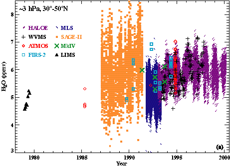
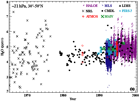
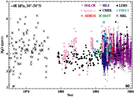
Figure 2.67 Water vapour time series for several instruments covering the depth of the stratosphere. Data plotted are individual measurements with the exception of LIMS (monthly averages), WVMS (weekly averages), and NOAA-AL Lyman-alpha (1 minute averages). Data below 100 hPa have been screened to omit tropospheric measurements. Six levels are plotted: a) ~3 hPa, b) ~21 hPa, c) ~68 hPa, d) 110-140 hPa, e) 140-170 hPa, and f) 170-210 hPa.
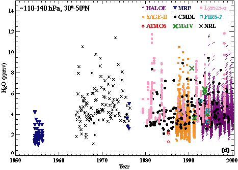
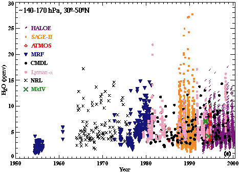
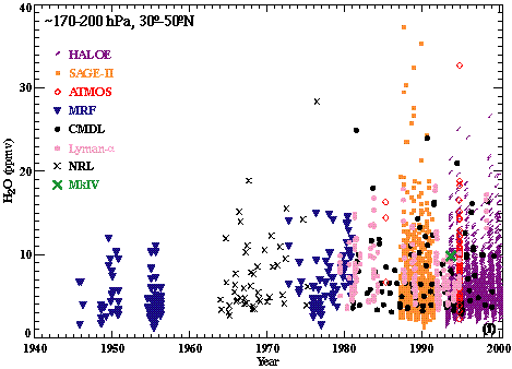
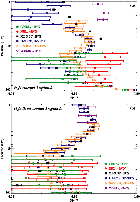
Figure 2.68. Water vapour mixing ratio annual (a) and semi-annual (b) amplitudes for the 30º to 50ºN latitude range. Instruments and latitudes used are noted on the figure. Error bars indicate the 1s uncertainties on the coefficients from the regression analysis.
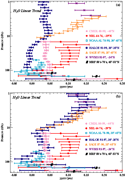
Figure 2.69. Water vapour mixing ratio linear change coefficient. Instruments, latitudes and valid time periods used are noted on the figure. Error bars indicate the 1s uncertainties on the coefficients from the linear regression analysis. Panel (a) and Panel (b) are identical with the exception of the HALOE time period used. Panel (a) shows the HALOE linear change term computed for 1993-1999, while Panel (b) shows the HALOE linear change term computed for 1993-1997.
To quantify the temporal changes in the data shown above, a linear regression was done with all the time series of water vapour data available. In order to estimate harmonic amplitudes and long-term changes, a linear least squares regression was done for each time series using annual, semi-annual and linear change terms. The fits were done using data from individual measurements on constant pressure levels, with the exception of the WVMS time series which used one-week averages, and the Lyman-a aircraft data which used 10-second averages. In some cases, data was interpolated to constant pressure levels to do the regression. In an attempt to avoid periods of heaviest aerosol loading which can detrimentally impact retrieved water vapour amounts, the first year of the SAGE II and HALOE data sets were not included in the calculation. The remaining SAGE II data were filtered according to the aerosol cut-off given in Rind et al. [1993]. The algorithm used for the regression is detailed in Bevington [1969]. The regression was done with equal weighting on each point, and the 1-s uncertainties were estimated as detailed in Chapter 15 of Press et al. [1996].
Because latitudinal coverage for HALOE, SAGE II and MLS varies throughout the year, the 30º-35º N band was used for HALOE and MLS, and the 35º-45º N band was used for SAGE II to obtain the best possible seasonal cycle amplitude estimates. This does not affect the long-term change determination significantly, but does affect the annual cycle amplitude calculation. Because of the short time record for the MLS stratospheric water vapour measurements, MLS is only used in the seasonal cycle amplitude computations. POAM III and ILAS satellite measurements were not used for a seasonal cycle determination because neither instrument's latitudinal coverage overlaps the Northern Hemisphere mid latitude band considered. Some instruments do not have adequate seasonal coverage to make an annual cycle amplitude estimate, but have a long enough time record that they can be used for estimating long-term changes. These include the remote sounding balloon- or shuttle-borne instruments, MkIV and FIRS-2, ATMOS, and the airborne MRF frostpoint and NOAA-AL Lyman-a instruments. The WVMS ground based remote sounding measurement were used for both annual cycle and long-term change determination in the upper stratosphere as were the in situ NOAA-CMDL frostpoint hygrometer measurements over Boulder, CO and the NRL frostpoint hygrometer measurements over Washington D.C.
The results for the annual cycle amplitude determination as a function of altitude in the Northern Hemisphere middle latitude band are shown in Figure 2.68a. Common to all data sets is a decrease in annual amplitude from 200 hPa to ~25 hPa. Between 20 and 3 hPa, only satellite data are available. There the shape of the satellite derived annual amplitude curves is similar for the three instruments, although with significant differences in magnitude. These differences between satellite derived amplitudes are quite large near 3 hPa, and also near 20 hPa. Above 3 hPa, the three available instruments (MLS, WVMS and HALOE) have different profile shapes, with annual amplitude differences of 200% or greater. Doing the regression analysis using an identical time period for the HALOE and WVMS data improves the agreement slightly, while using the identical time period for HALOE and MLS improves the annual amplitude agreement a great deal. Changes in the computed amplitude as a function of time period used in the regression are greatest above 8 hPa, although there are changes throughout the entire vertical profile.
Semi-annual amplitudes are plotted in Figure 2.68b. The uncertainties on the in situ measurements are large, indicating that data sampling is not sufficient to resolve the small amplitude semi-annual cycle. In the upper stratosphere, the semi-annual amplitude is larger, and the profile shapes and magnitudes are consistent between the satellite and WVMS measurements.
The results for the long-term change determination as a function of altitude for the Northern Hemisphere middle latitudes are shown in Figure 2.69a. The average long-term change of all the instruments plotted is 0.05 ppmv/year. It should be noted that even more so than for the annual amplitude, the time period chosen to do the regression analysis makes a large difference on the computed linear change. Doing the fit for the NOAA-CMDL data for just the first 5 years of the record (not shown) gives a linear change very similar to the NRL calculation, while using the last 5 years of the NOAA-CMDL record gives a linear change similar to the HALOE results. Matching the HALOE regression period to that of the WVMS record (Figure 2.69b) changes the estimated HALOE long-term changes by over 0.08 ppmv/year. This results in improved agreement between WVMS and HALOE determined long-term changes, and gives magnitude and profile shape quite similar to that computed for the SAGE II time period. The fact that the HALOE long-term changes are quite different when computed for different time periods demonstrates that the long-term water vapour change is not well modelled by a linear term. There are periods of rapid increase, and periods of little change or a decrease with time. This is also evident in the NOAA-CMDL and NRL records, and was noted by Mastenbrook and Oltmans [1983].
The MkIV, FIRS-2 and ATMOS instruments also have sufficiently long time records to consider a long-term change analysis. However, because of sampling issues, they cannot be calculated in the same manner as done for the data described previously. ATMOS flew on the space shuttle four times between 1985 and 1994; MkIV and FIRS-2 each had a small number of balloon launches at Northern Hemisphere sites. One method of determining a long-term change from the ATMOS data is described in Michelsen et al. [2000] and examines changes in the intercept calculated from CH4/H2O slope lines. For this study, a different approach was taken, and the water vapour data was first binned according to its measured N2O. N2O was chosen as opposed to CH4 because FIRS-2 data set does not include CH4. The main assumption made is that N2O acts as a proxy for the length of time air has been in the stratosphere. This then allows a more extensive time series to be constructed from data collected at different altitudes and latitudes than would be possible considering a single latitude band. Implicit in this assumption is that there are not significant changes in N2O chemistry during the time period considered. While the long-term changes plotted in Figure 2.69 will include a dynamical component possibly due to circulation changes, this method of binning should minimise that component. A positive trend in the N2O binned water vapour should then indicate changes in the effective entry value of water into the stratosphere, or changes in chemical processes in the stratosphere affecting water vapour.
In Figure 2.70, the N2O binned time series for ATMOS, MkIV and FIRS-2 are plotted. The ATMOS data only includes measurements north of 50ºS to avoid an incident of polar dehydration encountered during the final ATMOS shuttle flight. For these calculations, a linear least squares fit was done using instrumental weighting [Bevington, 1969]. Results of the fit are shown in Figure 2.71. One concern in doing such an analysis is that tropospheric N2O itself is also changing with time. However, the change over the period of consideration here is ~0.7 ppbv/year [Butler et al., 1998], yielding a net change of ~9 ppbv over the time frame considered. The minimum bin size used in the trend analysis is 25 ppbv, so the N2O trend should not greatly impact the analysis. At N2O values below 200 ppbv, where the influence of the seasonal cycle in tropical lower stratospheric water should be a minimum, ATMOS and MkIV show significant increases at all levels. FIRS-2 shows significant increases at all levels except the 105 ppbv N2O bin. Averaging the estimates for N2O values less than 200 ppbv gives an increase of 0.05 ppmv/year between 1985 and 1997. This is consistent with that estimated from Figure 2.69a in the Northern Hemisphere 30º-50ºN latitude bin. If each of the N2O series used is corrected to 1985 values, the average is 0.047 ppmv/year, demonstrating that the N2O trend does not significantly impact the calculated water vapour long-term change. Long-term changes for CH4 can also be computed for the ATMOS and MkIV data, and these are in general positive, with an average value of 0.006 ppmv/year. Methane long-term changes therefore do not negate the water vapour changes. This implies there has been a change in the actual average entry value of 2¥CH4+H2O into the stratosphere, and not simply a redistribution of hydrogen between methane and water due to possible circulation changes affecting the length of time air parcels have been resident in the stratosphere.
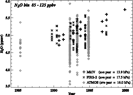
Figure 2.70 Water vapour time series for the MkIV, FIRS-2 and ATMOS instruments in the 85-125 ppbv N2O bin, representative of the middle stratosphere.
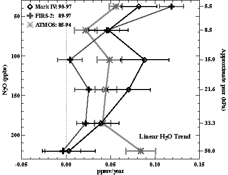
Figure 2.71 Water vapour linear change coefficient for the MkIV, FIRS-2 and ATMOS instruments. Data were binned by N2O prior to doing the regression analysis. The approximate pressure valid for each N2O bin is given on the right vertical axis. Error bars are the 1s uncertainties on the coefficients from the linear regression analysis. Years for each instrument are noted on the figure.
One problem with fitting the series with a linear term is that the long-term changes are not well described by a simple linear term. The lack of overlap of error bars in Figure 2.69 and 2.71 does not necessarily indicate errors in the measurements, but a failure of the imposed model to represent the actual time series. Different time periods are represented by each of the instruments considered, and the actual long-term change over those time periods may very well be different. It is probable that dynamical processes within the stratosphere are playing a role in the long-term water vapour changes computed in a single latitude band. They are undoubtedly playing a major role in producing the large range in the estimated water vapour trends seen in Figure 2.69. However, a similar analysis done with HALOE 2¥CH4+H2O also shows large differences in the linear term computed for different time periods, with sign changes depending on whether the beginning or end of the HALOE record is examined (not shown). Using the quantity 2¥CH4+H2O should filter out trends due to dynamical variability in a single latitude band. However, the fact that the linear term changes sign depending on the time period chosen implies there are multi-year changes in the average value of water into the stratosphere, with some periods of increase and some of decrease. Yet, when the entire multi-instrument time series is considered, there is evidence for a substantial increase of stratospheric water vapour over the past 40-50 years with an average magnitude of ~0.05 ppmv/year (1%/year). This corresponds to an increase of ~2.0 ppmv, or ~60% increase of lower stratospheric water vapour since the middle 1950's.