2.4 Comparisons between satellite systems
2.4.1 ATMOS Comparisons
MAS
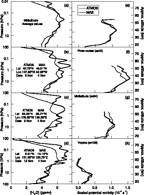
Figure 2.47 shows comparisons between ATMOS and MAS profiles from the ATLAS-3 mission. To account for atmospheric dynamical variability, the data (left panels) were sorted based on the scaled potential vorticity (sPV) derived from United Kingdom Meteorological Office (UKMO)-analysed winds (right panels) [Manney et al., 1994]. Figures 2.47a and 2.47e show unweighted mean values of 10 middle latitude profiles for each instrument. Each ATMOS profile used in the average was paired with a MAS profile with comparable sPV. The data in Figures 2.47b and 2.47f are individual profiles obtained inside the developing vortex (proto-vortex). The data in Figures 2.47c and 2.48g are individual profiles more characteristic of middle latitude (extra-vortex/extra-tropical) air, and the data in Figures 2.47d and 2.47h are associated with tropical air. The comparisons of the individual profiles presented in Figures 2.47b-d suggest that the ATMOS data have a wet bias in the mesosphere relative to MAS, but the averaged profiles in Figure 2.47a indicate that this difference is not statistically significant. Figure 2.48a presents percent differences for the individual profiles shown in Figures 2.47b-d, and Figure 2.48b shows the average percent and RMS differences for the paired profiles used to produce Figure 2.47a. Figure 2.48 shows differences between ATMOS and MAS are generally within 5% in the middle and upper stratosphere. The variability is large, however, and differences between individual profiles are shown to be as high as 30% in the lower stratosphere and mesosphere, where ATMOS measurements tend to be larger.
HALOE
During the ATLAS-3 mission, ATMOS and HALOE were making observations in the same latitude region of the Northern Hemisphere. Figure 2.49a shows unweighted mean values of 10 middle latitude profiles for each instrument. Each ATMOS profile used in the average was paired with a HALOE profile with comparable sPV. Figures 2.49b-d show comparisons of individual ATMOS/ATLAS-3 sunset occultations with near coincident HALOE Version 19 sunset and sunrise occultations. Figures 2.49e-h show the sPV profiles corresponding to the ATMOS and HALOE profiles presented in Figures 2.49a-d. The ATMOS profiles are the same as those plotted in Figure 2.47 for comparison with MAS observations and represent observations from inside the proto-vortex (Figures 2.49b and 2.49f), at middle latitudes (Figures 2.49c and 2.49g), and in the tropics (Figures 2.49d and 2.49h). Shapes of the profiles in Figures 2.49a-d are very similar, even in the upper mesosphere. In particular, there is a match in the vertical registration of these profiles.
The percent differences between the individual ATMOS and HALOE observations shown in Figures 2.49b-d are presented in Figure 2.50a. Figure 2.50b shows the percent and RMS differences for the 10 paired profiles averaged for Figure 2.49a. Both panels show that the differences between these instruments are generally less than 10%, and are of order 5% (ATMOS larger) between 100 and 1 hPa; the RMS differences are slightly larger. Greater differences (as much as 30%) are observed in the mesosphere and lower stratosphere. Given the large random error, however, the systematic differences are not statistically significant. These differences are smaller than in a previous comparison of ATMOS Version 2 data with HALOE Version 17 observations, which showed that the ATMOS values were systematically larger than those from HALOE in the middle stratosphere by 10-15% [Harries et al., 1996].
Figure 2.47. Comparison of ATMOS Version 3 with MAS observations of H2O. The volume mixing ratio of H2O is plotted as a function of pressure. The left panels (a-d) show ATMOS Version 3 (solid lines) and MAS (dotted lines) observations. The right panels (e-h) show the scaled potential vorticity corresponding to the measurements.
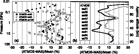
Figure 2.48 Percent differences between ATMOS Version 3 and MAS observations of H2O. (a) The percent differences for the observations compared in Figure 2.47 are shown as a function of pressure. (b) The (unweighted) average percent differences for the 10 profile pairs averaged for Figure 2.47a (solid line) are shown with the calculated RMS difference (dotted line).
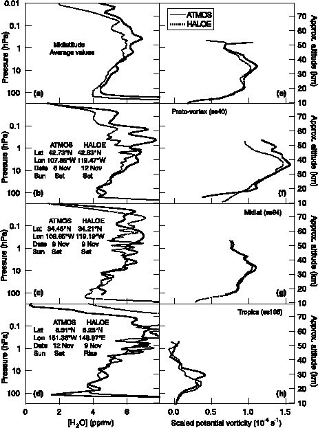
Figure 2.49 Comparison of ATMOS Version 3 with HALOE observations of H2O. The volume mixing ratio of H2O is plotted as a function of pressure. The left panels show ATMOS Version 3 (solid lines) and HALOE Version 19 (dotted lines) retrievals. The right panels show the scaled potential vorticity corresponding to the measurements.
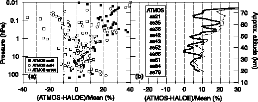
Figure 2.50 Percent differences between ATMOS Version 3 and HALOE Version 19 retrievals of H2O. (a) The percent differences for the observations compared in Figure 2.49 are shown as a function of pressure. (b) The (unweighted) average percent differences for the 10 profile pairs averaged for Figure 2.49a (solid line) are shown with the calculated RMS difference (dotted line).
MLS
The left panels of Figure 2.51 show a comparison of ATMOS Version 3 data with MLS prototype Version 0104 observations [Pumphrey, 1999]. The ATMOS data shown represent mean values from sunset occultations at southern middle latitudes and were made during ATLAS-1 (25 March-2 April 1992) and ATLAS-2 (8-16 April 1993). The MLS data were similarly averaged and collected during the same time period and in the same latitude range. The data were sorted, as above, based on scaled potential vorticity, mean values of which are displayed in the right panels of Figure 2.51. The error bars represent one standard deviation of the mean. The data in the bottom set of panels is from 1993, and the other 2 sets of panels show data from 1992, inside and outside the developing vortex. In all 3 cases, the ATMOS data exceed the MLS measurements. The difference is consistently ~0.6 ppmv in the middle and upper stratosphere, but decreases in the mesosphere, as shown by Figure 2.52a. This offset is consistent with a recent comparison of MLS Version 0104 with ATMOS Version 2 water vapour observations [Pumphrey, 1999] and corresponds to a percent difference of -15% throughout most of the stratosphere, as demonstrated in Figure 2.52b. Below 15 hPa for the 1993 middle latitude case, only a single profile was available from ATMOS; hence, the large fluctuation in the differences between the data sets at ~20 hPa for this case should be viewed with caution. The large variability in the lower stratosphere and mesosphere, on the other hand, is apparent in all 3 cases.
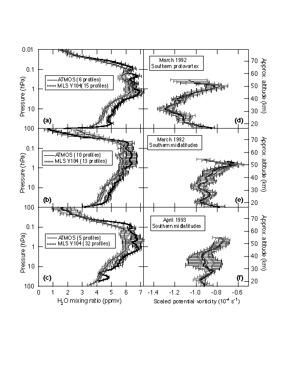
Figure 2.51 Comparison of ATMOS Version 3 with MLS Version 0104 retrievals of H2O from southern middle latitudes during 1992 and 1993. Mean (unweighted) profiles are shown for MLS (dotted lines) and ATMOS (solid lines) occultations from (a) and (b) ATLAS-1 and (c) ATLAS-2. (a)-(c) The (unweighted) average volume mixing ratio of H2O is plotted as a function of pressure. (d)-(f) The mean scaled potential vorticity corresponding to the measurements is also shown. The error bars represent one standard deviation (1s) of the unweighted mean.
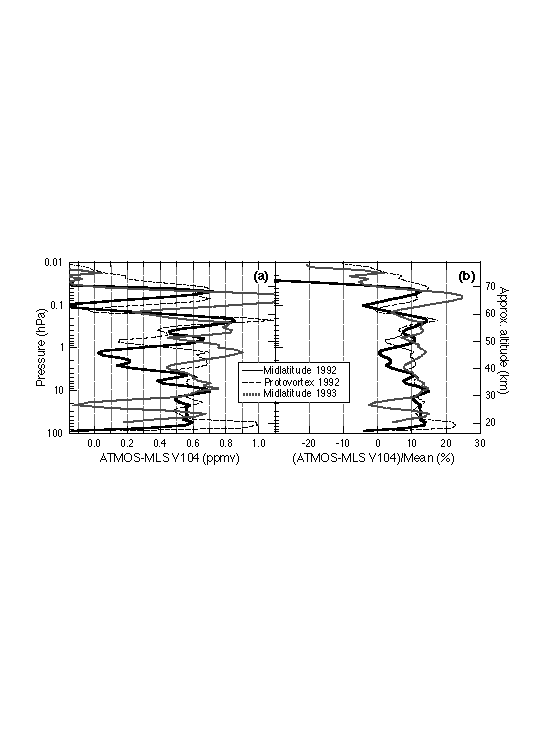
Figure 2.52 Differences between ATMOS Version 3 and MLS Version 0104 retrievals of H2O. The absolute differences (a) and the percent differences (b) of the mean profiles compared in Figure 2.51 are shown as a function of pressure.
2.4.2 MLS with HALOE
In this section, we show a comparison between MLS and HALOE. The comparison was done by taking every HALOE profile, finding the closest MLS profile, and taking the difference. These differences were then averaged, both for all latitudes and in 10º latitude bins. The comparison was carried out for the period between 12 October 1991 and 15 April 1993 covering the entire period for which both instruments were taking water vapour data. The global mean difference, indicating the bias between the two instruments, is shown in Figure 2.53 (right panel) as a solid line. Throughout the stratosphere and mesosphere this bias is small (0.1-0.3 ppmv) and negative (MLS drier than HALOE). In the upper mesosphere, MLS has a large dry bias compared to HALOE.
The systematic bias between the two instruments is not entirely independent of latitude. Figure 2.54 shows a contour plot of the difference as a function of latitude and height. In the mid-stratosphere and above, the bias depends only on altitude, but in the lower stratosphere, a strong latitude dependence is evident. In middle latitudes, MLS is 0.3-0.5 ppmv drier than HALOE, while over the equator, MLS is up to 0.3 ppmv wetter than HALOE.
Inspection of the differences as a function of time (not shown) suggests that the positive bias found in the equatorial lower stratosphere was largest at the beginning of the period, and had vanished or become slightly negative by the beginning of 1993. It is likely that it is caused by the effect of Mount Pinatubo aerosol on the HALOE data retrieval. In the absence of an unusual aerosol loading, the MLS-HALOE bias in the lower stratosphere would probably be about 0.4 ppmv, independent of latitude.
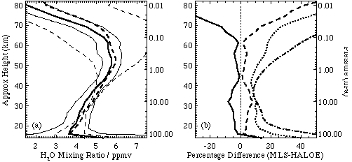
Figure 2.53 Panel (a): mean MLS (V0104) profile (solid lines) and mean HALOE (V19) profile (dashed lines) for the period 12 October 1991 to 15 April 1993. Thick lines are the profiles, thin lines indicate the mean single-profile uncertainty supplied with each data set. Panel (b): difference between MLS (V0104) and HALOE (V19) data. The solid line is the mean difference. The dotted line is the root-mean-square difference. This is generally much larger than the absolute value of the mean difference (shown dashed) indicating that random errors are a large part of the difference between the two instruments. In the stratosphere the RMS difference is similar to, or smaller than, the combined quoted uncertainties of the two instruments (shown as a dot-dash line) indicating that the quoted uncertainties are consistent with the differences between the instruments. In the mesosphere the quoted errors for the HALOE data are much larger than the MLS-HALOE difference.
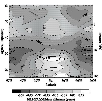
Figure 2.54 Contour plot of the mean difference between MLS and HALOE. Positive values (solid contour lines) imply that MLS is "wetter" than HALOE, negative values (dashed contour lines) imply that HALOE is "wetter" than MLS.
2.4.3 POAM III with HALOE
The POAM III satellite instrument was launched in March 1998 and is currently operational. During this time period the only other satellite-based stratospheric water vapour measurements available for comparisons are those obtained from HALOE. In this section, we compare POAM III Version 2 and HALOE Version 19 water vapour retrievals for 1998 and 1999. Lucke et al. [1999] shows the POAM III and HALOE measurement coverage in both hemispheres, indicating that POAM III-HALOE measurement coincidences occur in the spring and summer in each hemisphere. The times, location, and number of pairs of coincident profiles obtained since the launch of POAM III using coincidence criteria of 5° latitude, 12° longitude, and 12 hours are given in Table 2.2. As example comparisons, Figure 2.55 shows the results for the 11-12 June 1998 Northern Hemisphere orbit coincidence period. The left panel compares the average POAM III and HALOE water vapour mixing ratio profiles for the coincidence period. The middle panel gives the mean difference of the individual coincident pairs (1/Nå (POAM-HALOE)/[(POAM+HALOE)/2]) expressed in percent. The right panel shows the standard deviation (1s ) of the mean difference, which is a measure of the combined random error of both instruments and atmospheric variability. The error bars on the centre plot are given by s /(N-1)-1/2, where N is the number of coincident pairs.
Table 2.2. POAM III - HALOE Coincidence Periods
|
|
|
||||
|
|
|
|
|
|
|
| POAM | HALOE | ||||
|
|
29 | 59.7ºN | 62.7ºN | ||
|
|
27 | 55.3ºN | 58.4ºN | ||
|
|
14 | 55.7ºN | 59.7ºN | ||
|
|
24 | 61.7ºN | 64.8ºN | ||
|
|
|||||
|
|
82 | 70.8ºS | 70.4ºS | ||
|
|
116 | 65.2ºS | 65.5ºS | ||
|
|
103 | 64.6ºS | 65.7ºS | ||
|
|
72 | 71.1ºS | 72.3ºS | ||
|
|
|||||
|
|
123 | 67.0ºN | 64.3ºN | ||
|
|
28 | 60.6ºN | 63.6ºN | ||
|
|
7 | 55.9ºN | 60.3ºN | ||
|
|
5 | 55.1ºN | 58.7ºN | ||
|
|
16 | 60.6ºN | 62.5ºN | ||
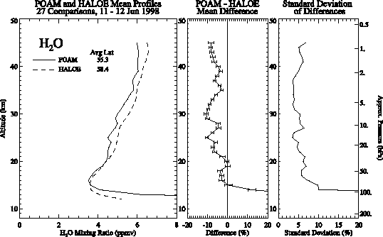
Figure 2.55 (left panel) Mean POAM III and HALOE water vapour mixing ratio profiles for the indicated coincidence period. (middle panel) Mean of the POAM III-HALOE individual profile differences expressed in percentage relative to the POAM III/HALOE average. Error bars are the ± 1s standard errors of the mean (see text). (right panel) Standard deviation (1s) of the mean differences is shown in the middle panel.
The overall mean differences for both hemispheres are given in Figure 2.56. The comparisons show that at nearly all altitudes above 15 km, POAM III and HALOE are within 10% of each other. The divergence below 15 km appears to be the result of instrument differences in resolving the hygropause. There is also evidence of a hemispheric bias, with POAM III mixing ratios tending to be biased low with respect to HALOE in the Northern Hemisphere, and high in the Southern Hemisphere. This could be indicative of a sunrise/sunset bias in the POAM III water vapour retrievals (all POAM III Northern Hemisphere measurements are obtained during satellite sunrise and all Southern Hemisphere measurements during sunset). However, as shown in Table 2.2, the HALOE measurements are systematically poleward of the POAM III measurements in the Northern Hemisphere comparisons. This occurs because of systematic gaps in the HALOE measurement coverage, near 50º latitude, which have occurred since April 1997 as a consequence of power sharing issues on board UARS. Climatologically, water vapour tends to increase with latitude in the Northern Hemisphere stratosphere [Randel et al., 1998]. This latitudinal gradient will act to mitigate the apparent hemispheric bias in Figure 2.56. As a rough estimate of the magnitude of the effect, the UARS climatology developed by Randel et al. [1998] indicates that the water vapour latitudinal gradient may explain roughly half of the apparent hemispheric bias.
Finally, we note that the POAM III-HALOE differences exhibited in this report are considerably smaller than those shown in the HALOE Version 18 and POAM III Version 1.4 comparisons given in Lucke et al. [1999], which showed a 10-30% POAM high bias. This is the result of the fact that a recent analysis by Giver et al. [2000] indicates that there is a 14.4% error in the line strengths of the water vapour absorption lines in the 900 nm region in the HITRAN database used in the POAM III retrieval algorithm. The inclusion of this correction in the POAM III version 2 retrievals shown here reduces water vapour mixing ratio by ~14.4% in the upper stratosphere, and by ~20-25% in the lower stratosphere.
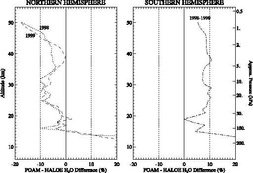
Figure 2.56 The overall mean POAM III-HALOE differences for all coincidences obtained each year (the coincidences included in these comparisons are given in Table 2.3) in the Northern Hemisphere (left panel) and Southern Hemisphere (right panel).
Table 2.3. ILAS-HALOE coincidence within 300 km in distance and 12 hours in time.
|
|
Number of Coincidences | Average Latitude & Sunrise/Sunset1 |
|
|||
| ILAS | HALOE | |||||
| 19-24 November 1996 | 41 | -68.7 | SS | -68.9 | SR | SH |
| 10-16 December 1996 | 38 | -64.9 | SS | -65.6 | SS | SH |
| 28-31 January 1997 | 22 | -68.6 | SS | -69.6 | SR | SH |
| 18-20 February 1997 | 21 | -75.6 | SS | -74.8 | SS | SH |
| 25 March?1 April 1997 | 54 | 68.5 | SR | 68.1 | SS | NH |
| 13-14 May 1997 | 12 | 61.2 | SR | 61.1 | SR | NH |
| 16-18 June 1997 | 13 | 57.0 | SR | 57.2 | SS | NH |
Total number of coincidences: 201 (SH 122; NH: 79)
1 SR: Sunrise from satellite; SS: Sunset from satellite
2 SH: Southern Hemisphere; NH: Northern Hemisphere
2.4.4 ILAS with HALOE
In this section, ILAS Version 4.20 and HALOE Version 19 water vapour retrievals for the entire ILAS period between November 1996 and June 1997 are compared. Coincidence latitudes are restricted by the ILAS high latitude coverage ranging from 57 to 73 degrees in the Northern Hemisphere and from 64 to 88 degrees in the Southern Hemisphere, depending on the season (see section 1.4.9). The times, locations, and number of pairs of coincident profiles using a coincidence criterion of 300 km in distance and 12 hours in time are given in Table 2.3.
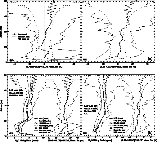
Figure 2.57 Mean, minimum, and maximum of (ILAS-HALOE)/HALOE expressed in percentage for (a) left panel: 122 coincidences in the Southern Hemisphere, right panel: 79 coincidences in the Northern Hemisphere. "RSS meas. err." shows average of root sum square of ILAS and HALOE measurement errors. (b) left panel: Mean, minimum, and maximum of ILAS and HALOE water vapour mixing ratio profiles for 41 comparisons of Southern Hemisphere measurements from 19-24 Nov. 1996, right panel: for 54 comparisons of Northern Hemisphere measurements from 25 Mar.-1 Apr. 1997.
Coincidences occur in the Southern Hemisphere during November 1996 - February 1997, and in the Northern Hemisphere during March - June 1997. All ILAS Northern Hemisphere measurements are obtained during satellite sunrise (SR), and all Southern Hemisphere measurements during sunset (SS). Figure 2.57a shows the results of all the ILAS-HALOE comparisons. Between 13 and 35 km, ILAS and HALOE are within 10% of each other. Above 35-km altitude, the range of the comparisons is large because the ILAS retrievals exhibit vertical oscillations that are larger than anticipated (see section 1.4.9). The larger range below 12 km is likely due to instrument differences in resolving the hygropause or other unknown factors. ILAS measurements are biased high relative to HALOE above 16 km in the Northern Hemisphere. For the Southern Hemisphere comparisons, ILAS measurements are biased high relative to HALOE at all levels except between 17 and 25 km.
Comparisons for the periods in each hemisphere with the maximum number of coincidences noted in Table 2.3 are shown in Figure 2.57b (19- 24 November 1996, Southern Hemisphere; 25 March-1 April, Northern Hemisphere). The mean profiles of both ILAS and HALOE in Figure 2.57b show similar vertical structure, with minimum at ~15 km, maximum at ~22 km, and a secondary minimum at ~27 km. This is also seen in both instruments during the period of 10-16 December 1996 (not shown). The vertical structure for both instruments also agrees well during the Northern Hemisphere period shown in Figure 2.57b, with water vapour mixing ratio increasing with altitude up to about 25 km and then nearly constant above that level. Average differences throughout the bulk of the stratosphere are 10% or less.
2.4.5 TOVS/HIRS upper tropospheric comparisons
MLS
At low latitudes, the sampling of upper tropospheric humidity with respect to ice (UTHi) by MLS and TOVS produces similar results on monthly mean grid boxes of 2.5º latitude by 2.5º longitude. Figure 2.58 shows a scatter diagram of these results for 4 months in 1991/1992. The figure also includes the mean and standard deviation estimate for averaging within 5% UTHi bins. The comparison was performed for the MLS layer at 316 hPa, corresponding to the peak of the HIRS channel 12 weighting function for moderate UTHi values. The correlations are 0.64 in October 1991, 0.51 in January 1992, 0.50 in April 1992, and 0.74 in July 1992. The overall range of HIRS UTHi is less in January and April, which partially explains the smaller correlations in these months. The standard deviations, however, remain very close to 18% for all months. The MLS only samples each grid box a few times per month while the HIRS samples each box 50-100 times. Thus, most of the scatter can be attributed to sampling as opposed to error between the observations. Averaging into 5% UTHi bins allows for the evaluation of the relative bias between MLS and TOVS as a function of the base UTHi. At low and high values of UTHi, the MLS shows a slightly low bias relative to TOVS, while in the middle range there is virtually no bias. The bias at the high and low ends is likely due to sampling, as there are only a very few coincident observations. HIRS and MLS therefore appear to produce highly comparable observations on monthly averaged time scales. At higher time and space scales, the comparisons show larger standard deviations and biases. This is both a reflection of sampling bias and differences in viewing geometry.
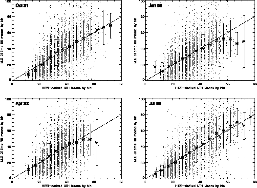
Figure 2.58 Scatter diagrams of TOVS-MLS comparisons. Grid boxes used were 2.5° latitude by 2.5° longitude. Comparisons were done between 30° N and 30° S.
SAGE II
Since SAGE II uses solar occultation to retrieve water vapour, it is very sensitive to any cloud or high aerosol amount in its limb path. Monthly mean plots of SAGE II data on a 2.5º by 2.5º bin show that SAGE II does not retrieve water vapour in the centres of the seasonal monsoons or the Inter-tropical Convergence Zone. Simple zonal averaging of the SAGE II data is therefore not appropriate in the tropics.
SAGE II retrieves the water vapour mixing ratio at given pressure levels, therefore, integrated upper tropospheric water vapour between SAGE II levels ranging from 200 to 500 hPa was computed in order to perform comparisons between SAGE II and TOVS. These data were then binned on a 2.5º latitude by 2.5º longitude grid. Since the SAGE II is in units of integrated water vapour, these data must be compared with TOVS retrievals of integrated water vapour from the 3I method (described in Chapter 1). Figure 2.59 shows scatter plots between SAGE II and TOVS 3I at grid boxes common to both data sets for four months in 1988. The correlations vary by a large amount ranging from a low of 0.33 in January 1988, to a high of 0.64 in July 1988. The correlations were 0.49 in April 1988 and 0.52 in October 1988. The RMS deviations are moderate, ranging from 0.43 mm in January to 0.56 in July. In all months, the dynamic range of the SAGE II data is larger than that of TOVS 3I. This likely indicates a basic sampling mismatch between the two observational data sets. SAGE II sampling is apparently insufficient to properly characterise the variability of upper tropospheric water vapour captured by the TOVS sampling.
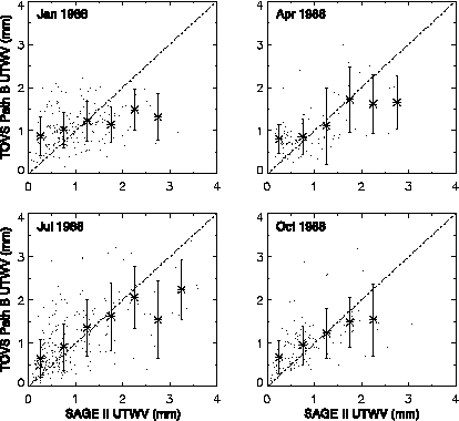
Figure 2.59 Scatter plots between SAGE II and TOVS 3I only at grid boxes common to both data sets for four months in 1988. SAGE II data are integrated between 200 and 500 hPa. Grid boxes used are 2.5º latitude by 2.5º longitude. TOVS 3I data processing is described in Chapter 1.