2.3 Comparisons made for the validation of satellite measurements
2.3.1. HALOE comparisons
In situ measurements
Aircraft measurements
In this subsection, intercomparisons are shown between HALOE profiles and in situ aircraft measurements of water vapour. Coincidences were required to occur within 2.5 days, 3 degrees of latitude, and 45 degrees of longitude. It can be argued that even these separations do not constitute coincidence, but choosing tighter criteria leads to fewer comparisons. Even though our comparisons with the aircraft data consist of only 5 profile pairs per set, the root-mean-square (RMS) differences for each set are not much larger than their mean differences. Thus, one can be confident that the individual profile pairs in each set are showing consistent differences. In Figures 2.18 to 2.24, the standard HALOE profiles are from its Version 19 (V19 or 3rd public release data set) and denoted with a solid curve, the correlative data are dotted, and recent updates to the HALOE retrieval are dashed. The right panels of each of these figures show the mean of the differences for the paired profiles (as opposed to the difference of the mean correlative and mean HALOE profiles of the left panels). RMS differences for the pairs are also shown in the right panels.
Sunrise (SR) and sunset (SS) HALOE comparisons were made with Harvard Lyman-a measurements [Weinstock et al., 1994] from multiple ER-2 missions occurring from October 1995 through May 1997 and from 20°N to 66°N. Comparisons do not extend above the 50 hPa level, which is about the upper flight level of the ER-2 aircraft measurements. The in situ measurements have a reported accuracy of ~5%. Comparisons were made against both climb and descent measurements from the ER-2, but the results were not significantly different. Figure 2.18 shows results for a set of five SR pairs whose average longitude separation was 14 degrees. A systematic, nearly constant mean offset of 15% to 20% was found for the HALOE V19 SR (solid) versus descent profiles from the ER-2 (dotted) for the entire interval from 50 hPa to 150 hPa (HALOE smaller). Very similar results were found for the SS comparisons (not shown), although the percentage differences are larger below the 150 hPa level. The overall shapes of the average HALOE and average in situ profiles are also very similar. Although the profile comparisons were obtained at latitudes near 20°N, 30°N to 40°N, and near 65°N, there is no clear variation with latitude for the comparison differences. Figure 2.18 includes the averages for modified HALOE V19 retrievals (dashed) that use no constraint in the procedure for vertically interleaving each of the 7 separate retrievals of a given scan and also use an improved model [Thibault et al., 1997] for the effects of the interfering pressure-induced O2 continuum for the cold temperatures of the lower stratosphere. Biases are reduced and those updates indicate the nature of the uncertainties that affect the V19 profiles in the lower stratosphere. Such algorithm improvements will be included in the upcoming Version 20 processing.
Similar comparisons were performed against the NOAA Lyman-a measurements on the ER-2. Figure 2.19 shows an average of five comparisons for descending flight legs at northern middle latitudes from November 1992 through November 1994. Average longitude separation is 8 degrees. Differences in water vapour range from 5% at 60 hPa to 20% at 130 hPa with HALOE being smaller. While the unconstrained results are somewhat noisy, the average profile is essentially the same as the V19 profile above the 120 hPa level without the modification to the O2 continuum. Below that level, the unconstrained results follow the aircraft data more closely than V19.
Figure 2.18 Average of 5 comparisons of HALOE SR/ER-2 Harvard Lyman-a profiles during aircraft descent, latitudes range from 20º to 64ºN. (left) Solid curve is HALOE average, dotted curve is Lyman-a. (right) Solid curve is mean difference (Lyman-a minus HALOE); dotted curve is RMS difference. The dashed curves show the effect of eliminating constraints plus a better correction for the O2 continuum in the V19 retrieval in the mean difference (left) and its percentage difference (right).
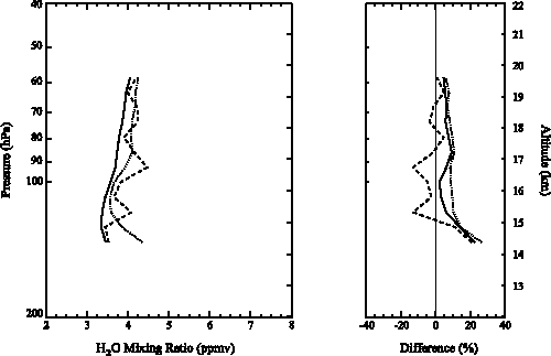
Figure 2.19 Average of 5 Northern Hemisphere comparisons of HALOE/ER-2 NOAA-AL Lyman-a profiles during aircraft descent, latitudes range from 34º to 39ºN. (left) Solid curve is HALOE, dotted curve is Lyman-a. (right) Solid curve is mean difference (Lyman-a minus HALOE); dotted curve is the RMS difference. Dashed curves show the effects of removing the constraints plus a better correction for the O2 continuum in the HALOE retrieval.
Figure 2.20 shows five comparisons with NOAA-AL Lyman-a measurements at southern middle latitudes for April through October 1994. Average longitude separation is 12 degrees. Although the shapes of the differences with the NOAA-AL data are similar in both Figures 19 and 20, their percentage differences are larger in the Southern Hemisphere. These comparisons for the Southern Hemisphere occurred in 1994, when the aerosol extinction tended to be less than that for most of the northern middle latitude pairings. It is likely that when the interference from aerosol absorption is large, as it was in 1992/1993, the uncertainties in the correction are more important than the effects of the positive bias in the earlier O2 continuum model being used for V19.
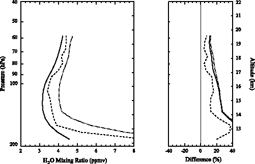
Figure 2.20 As in Figure 2.19, but for an average of 5 Southern Hemisphere comparisons, latitudes range from 41º to 47ºS.
Balloon frostpoint hygrometers
A set of 14 SR profile-pair comparisons with NOAA-CMDL frostpoint hygrometer measurements near 40°N makes up the statistical average shown in Figure 2.21. All pairs are coincident to within 1 day, 3 degrees of latitude, and 17 degrees of longitude. Average longitude separation for the set is 8 degrees. Cloud signatures have been screened out of the HALOE profiles, but their effects do not have an impact above the 150 hPa level. The mean difference profile shows agreement between the frostpoint and HALOE SR measurements to within 5% from 15 hPa to 70 hPa. Systematic differences between the two measurements reach 15% (HALOE smaller) at 100 hPa and 20% at 125 hPa. Because of profile imprecision, lack of better coincidence, atmospheric variability, and different spatial averaging for the two measurement techniques, the RMS differences in Figure 2.21 are larger than the mean differences. Those differences reach 10% from 15 hPa to 60 hPa, increasing to 20% at 100 hPa. Both the mean and RMS differences are well within the combined HALOE V19 and frostpoint estimates of accuracy. The HALOE V19 error estimates are the same as those for V17 reported in Harries et al. [1996]. The balloon measurement has an accuracy of about 10%, based mainly on the uncertainty in the frostpoint temperature (see Chapter 1.1). When the retrieval constraint is removed, the dashed HALOE profile "turns the corner" more sharply at about 150 hPa, resulting in smaller differences with the balloon profile.
Eleven HALOE SS comparisons with NOAA-CMDL frostpoint soundings were obtained, and the average result in Figure 2.22 is similar to that for SR. Average longitude separation is 14 degrees and time difference is less than 1 day. Several HALOE profiles stopped abruptly near 150 hPa, but no cloud was indicated by our screening criteria. Although the HALOE cloud-screening algorithm [Hervig and McHugh, 1999] indicated a cloud in several other cases, each comparison was still good at and below the cloud altitude indicated by the screening. This suggests that not all flagged cloud events are having a significant effect on the retrieved water vapour. Most of the SS profile pairs extend downward to the tropopause and agree to within the error bars for the two data sets. The small differences for both the SS and SR correlative comparison plots represent the primary improvement in the V19 retrievals of water vapour over earlier data versions.
Figure 2.21 (Left) Averages of 14 HALOE V19 SR profiles (solid) and frostpoint balloon profiles (dotted) near 40° N. Dashed curve represents the average HALOE profile obtained by removing an interlevel retrieval constraint plus using a better correction for the O2 continuum. (Right) Average differences (frostpoint minus HALOE V19) for the paired profiles in the set (solid); RMS differences for that set (dotted). Dashed curve is the mean difference for the modified HALOE algorithm.
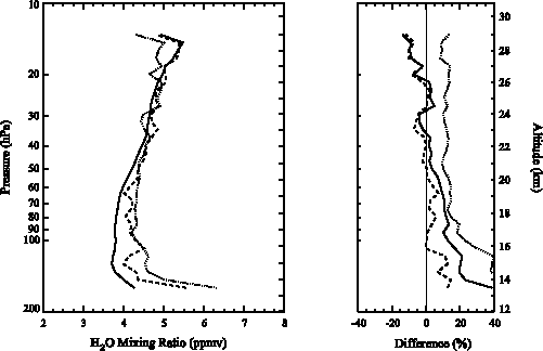
Figure 2.22 As in Figure 2.21, but for a set of 11 HALOE V19 SS comparisons.
Three comparisons have been made between HALOE SR profiles and LMD frostpoint hygrometer profiles [Ovarlez and Ovarlez, 1996; Ovarlez et al., 1996] in the region of Indonesia to Diego Garcia. Average longitude separation is 7 degrees. Figure 2.23 shows averages for these tropical comparisons of January 1994. HALOE values are smaller than the frostpoint by 15 to 20% between 25 hPa and 75 hPa. It should be noted that only one frostpoint profile extends below 60 hPa (note that the RMS difference in the right panel goes to zero at that point). Results for this small sample show larger differences than indicated for the sets of HALOE comparisons with the NOAA-CMDL frostpoint measurements over the same altitude range. For the comparison shown in Figure 2.24 at Kiruna, Sweden, on 20 March 1995, the profile shapes are similar. In this instance, HALOE is up to 15% larger between 25 hPa and 60 hPa but the differences are smaller above and below that altitude range. This comparison occurs near the early springtime polar vortex, where differences between a local and a path-averaged measurement may be an important factor. No modified V19 profile was generated for Figure 2.24.
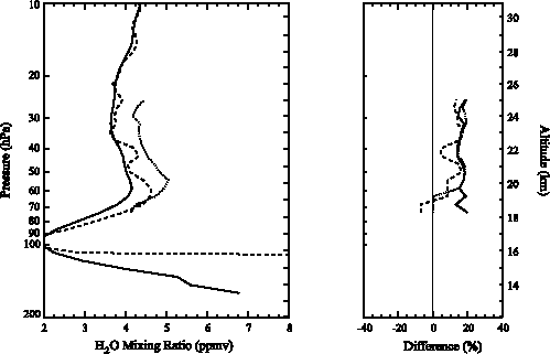
Figure 2.23 (left) Average of three HALOE (solid)/LMD frostpoint balloon (dotted) comparisons at tropical latitudes in January 1994. Dashed is HALOE result using its modified algorithm. (right) Average (solid or dashed) and RMS (dotted) differences.
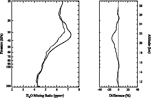
Figure 2.24 As in Figure 2.23, but for a single comparison at Kiruna, Sweden, in March 1995.
Jülich Lyman-a hygrometer (FISH)
One HALOE comparison opportunity was obtained with the Jülich Lyman-a hygrometer (FISH) on 20 September 1993, at 44°N, 0°W [Zöger et al., 1999b]. Comparisons are shown in Figure 2.25 with two nearby HALOE SS profiles from 21 and 22 September. Note that FISH data have been measured using the prototype instrument, resulting in less precise and noisier measurements than with the current instrument. In this comparison, the FISH profile was smoothed with a cosine bell function of width ±1.05 km, but this did not reduce its fine structure oscillations much. The difference is within the combined error bars for both instruments. When the FISH profile is convolved with the HALOE field of view (in order to reduce the noise and approximate the vertical resolution of the HALOE measurement), the in situ profile is altered where water vapour turns sharply and is biased toward larger values. At about the 150 hPa level the HALOE profiles in Figure 2.25 diverge somewhat; the interlevel retrieval constraint has not been eliminated for these comparisons. Nevertheless, the Jülich profile tends to split the differences for the nearby HALOE profiles at 100 hPa to 150 hPa. There is no clear HALOE bias with the FISH Lyman-a measurement below the 30 hPa level, even at the water vapour profile minimum. Minor differences only occur at low altitudes close to the tropopause, below 150 hPa, where both the precision and accuracy of the HALOE retrieval degrades. These differences are at variance with the preponderance of other HALOE comparisons with the Harvard and NOAA-AL Lyman-a profiles from the ER-2. More comparisons with the Jülich sonde would be helpful to see whether the agreement in Figure 2.25 is found repeatedly.
Figure 2.25 HALOE V19 SS comparisons with a vertically smoothed Jülich Lyman-a profile (dotted) on 20 September 1993, at 44° N, 0° E. The two nearby HALOE V19 profiles are from 22 September (solid) at 46° N, 351° E and 22 September (dashed) at 43° N, 14° E.
Remote sensing measurements
FIRS-2
Thus far, FIRS-2 has had three balloon flights coinciding with one or more HALOE occultation events, where observations made within 24 hours inside a radius of 850 km are considered coincident. A comparison of multiple FIRS-2 and HALOE profiles showed that local gradients are small enough for useful intercomparison for two of the flights. The selected flights were launched from Ft. Sumner, New Mexico on 29 September 1992 and 22 May 1994. Average FIRS-2 and HALOE (version 19) profiles are compared in Figure 2.26. Differences are generally less than 5%, with HALOE indicating larger water vapour mixing ratios than FIRS-2 above 30 km and smaller mixing ratios near the hygropause. The feature seen in the HALOE profile near 23 km results from a vortex fragment seen by HALOE in 1994 which was not observed in the FIRS-2 observations some 800 km to the south.
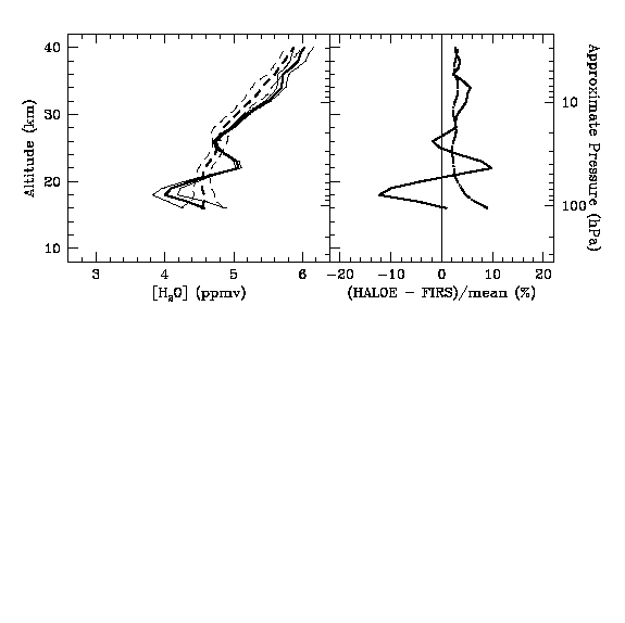
Figure 2.26 The left panel shows the comparison between average FIRS-2 (dashed curve) and HALOE version 19 (solid curve) profiles discussed in the text. The right panel shows the mean difference (solid curve) between FIRS-2 and HALOE, and estimated combined precision (dot-dash curve).
MkIV
MkIV balloon profiles meeting the criterion of being within 5º in latitude, 10º in longitude, and 3 days of a HALOE overpass, were selected for comparison. This latter criterion (3 days) may seem rather lenient, but one must remember that these MkIV balloon flights were all made at turn-around, when the winds in the middle and lower stratosphere are light and variable. Under turn-around conditions air masses do not move very far, even in three days. Only three of eight balloon flights made since 1992 met this criterion.
The first three panels of Figure 2.27 show all possible comparisons, with the H2O profiles observed at each location plotted. The 1993 September comparison is the closest in terms of the time separation. Here it is apparent that the HALOE profiles (open triangles) are systematically 10-20% less than those measured by MkIV (solid symbols). Two MkIV profiles were measured on this particular flight, a sunset (filled diamonds) and a sunrise (solid squares) 12 hours later. All of these MkIV and HALOE profiles were measured within a 35-hour period, and some within 1 hour of each other.
For the 1994 May profiles, little bias is apparent. However, this may be fortuitous given the MkIV profile was measured 3 days after most of the HALOE observations. Later HALOE profiles measured on the same date in 1994 May as the MkIV profile but 10º further north show much worse agreement with the MkIV profile than those presented here. The 1996 September intercomparison again shows the MkIV profile is systematically larger than the near coincident HALOE profiles, which were measured 35 hours after the MkIV profile.
The fourth panel of Figure 2.27 summarises the average biases obtained from each near coincident MkIV-HALOE pair. Above 20 km altitude the MkIV profiles are in general 5-10% (0.3-0.6 ppmv) larger than those measured by HALOE. Below the hygropause (typically 18 km), it becomes very difficult to determine a meaningful bias because the H2O volume mixing ratio is decreasing so rapidly with increasing altitude that even a small altitude difference can cause a large apparent discrepancy.
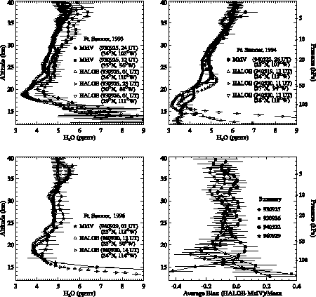
Figure 2.27 MkIV-HALOE comparisons for 3 balloon flights at Ft. Sumner, New Mexico. The first 3 panels show individual water vapour profiles, the final panel shows the average biases for each balloon flight.
Effects of the modified O2 continuum on the HALOE retrieval
In general, the HALOE comparisons with the in situ and remote sounding balloon measurements are within the uncertainties for HALOE water vapour in the lower stratosphere. With the inclusion of a modified O2 continuum and a less constrained retrieval, the differences become smaller in most cases. The effects of interference from the H2O continuum are not considered in the V19 algorithm. Inclusion of a model for the H2O continuum will decrease retrieved water vapour at low altitudes of the stratosphere and offset some of the changes brought about by the better O2 model. However, at this time it is not clear that an adequate model exists for characterising the effects of the H2O continuum at the low water vapour mixing ratios and cold temperatures of the lower stratosphere.
2.3.2 MLS comparisons
In this section, the MLS data are compared to various balloon-borne, airborne and ground-based data sets. The MLS data used are the prototype Version 0104 data described in Chapter 1.4.6 and [Pumphrey, 1999]. For each of the comparisons, the difference was taken between the non-MLS profile and the closest MLS profile for the same day. Less than 15º in longitude and 2º in latitude typically separate the two profiles. A mean difference is obtained by averaging over a number of pairs of profiles. This difference gives an indication of the systematic bias between the two instruments and is shown in the comparison figure as a solid line. The square of the difference is averaged and the square root taken to give a root-mean-square (RMS) difference shown in each comparison figure as a dotted line. The RMS difference will be equal to the absolute value of the mean difference if all of the difference is systematic and greater if some of the difference is random. To aid this comparison where the mean difference is negative, the absolute mean difference is shown in the figures as a dashed line. The RMS difference should be of a similar size to the root-sum-square combined uncertainties of the two measurements, which is shown in the figures as a dot-dash line.
Comparison with balloon frostpoint hygrometer
Comparisons are shown with both the NOAA-CMDL frostpoint and LMD frostpoint balloon instruments. There are 16 profiles from the NOAA-CMDL instrument for which reasonably close MLS measurements exist. Most of these profiles are equatorial or middle latitude profiles, with one profile taken in the Antarctic spring. Figure 2.28 shows the average of the MLS-CMDL differences. The short horizontal lines on the left show the levels at which the MLS data are retrieved. Between these levels, MLS mixing ratio is assumed to vary linearly with logarithmic pressure.
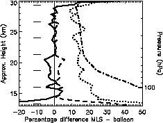
Figure 2.28 Comparison between the NOAA-CMDL frostpoint hygrometer and MLS. The solid line is the mean difference between the two instruments and the dotted line is the RMS difference. The dashed line is the absolute value of the mean difference. The dot-dash line represents the quoted errors for MLS. The line segments on the left side indicate the MLS retrieval levels.
Below 29 km, the bias between the NOAA-CMDL frostpoint and MLS is small compared to the random differences, and the RMS differences are similar to the errors supplied with the MLS data. Above 29 km, there are only a small number of comparisons. Figure 2.29 shows a similar comparison with the LMD frostpoint hygrometer. Seven profiles are available for which there are coincident MLS measurements. Of the seven profiles, six were taken at Kiruna in northern Sweden, the remaining one at Aire sur l’Adour, France. There are clear differences between the two comparisons. The LMD data show larger biases with MLS than do the NOAA-CMDL data, particularly at higher altitudes. Overall, MLS tends to show small differences with the NOAA-CMDL frostpoint balloon instrument, and is biased 8-20% low relative to the LMD frostpoint balloon instrument. Part of this discrepancy with the LMD may be due to the difficulty of obtaining matches within similar air masses at high latitudes during the winter.
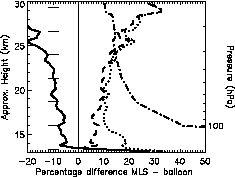
Figure 2.29 As Figure 2.28 but for the LMD balloon frostpoint hygrometer.
Comparisons with the Harvard Lyman-a instrument
Although a detailed comparison was not carried out between these two instruments, when the Harvard Lyman-a instrument flew on the ER-2 during the CEPEX campaign in March and April 1993, the Harvard instrument measured mixing ratios approximately 0.75 ppmv (~20%) larger than those seen by MLS. Most of the data is at a pressure of about 70 hPa and the flights were all made within 20º of the equator in latitude and between 170º and 180º E. longitude.
Comparison with ground-based microwave (WVMS)
A detailed comparison of the ground-based water vapour millimetre-wave spectrometer (WVMS) with other instruments is given by Nedoluha et al. [1997]. This paper and that of Lahoz et al. [1996] both show comparisons between WVMS and MLS version 3 data. Both MLS version 4 and prototype version 0104 discussed in this report show smaller differences with WVMS than does MLS version 3. Figure 2.30 shows the mean profiles from MLS and WVMS for the period 9 January to 9 February 1993, for the Lauder, New Zealand (45oS) WVMS site. The results from Table Mountain Observatory, California are similar. Figure 2.30b shows the mean and RMS differences between MLS and WVMS. WVMS and the MLS agree to within their quoted uncertainties at most levels. The systematic component of the difference is a substantial proportion of the total difference, but the difference is smaller than for earlier MLS versions. The most significant disagreement between the prototype and WVMS occurs at 0.2-0.3 hPa, where the MLS profiles show a notch. This feature probably has too small a vertical extent for WVMS to detect it.
Comparison with FIRS-2
The FIRS-2 has had three balloon flights coinciding with MLS overpasses, where observations made within 24 hours inside a circle with a 400 km radius are considered coincident. By comparing multiple FIRS-2, MLS, and HALOE profiles, it was determined that local gradients were small enough for useful intercomparison for two of the flights. The selected flights were launched from Ft. Sumner, New Mexico, on 29 September 1992 and from Barstow, California, on 23 March 1993. The average FIRS-2 and MLS (prototype version 0104) profiles are compared in Figure 2.31. Water vapour mixing ratios retrieved by MLS are generally smaller than those retrieved by FIRS-2, with the difference increasing from 5% near 3 hPa to 20% at 70 hPa.
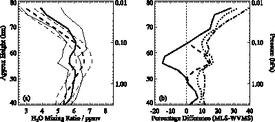
Figure 2.30 Panel (a) shows the mean WVMS (dashed) and mean coincident MLS (solid) profiles for the period 9 January to 9 February 1993 for the WVMS Lauder, New Zealand instrument. Panel (b) shows the percentage difference.
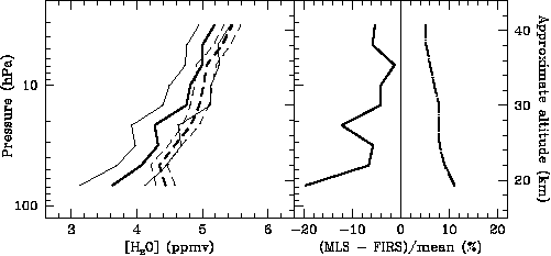
Figure 2.31 The left panel shows the comparison between average FIRS-2 (dashed curve) and MLS prototype 0104 (solid curve) profiles discussed in the text. The right panel shows the mean percentage difference (solid curve) between FIRS-2 and MLS, and estimated combined precision (dot- dash curve).
2.3.3 SAGE II comparisons
Five years of version 5.9 SAGE II water vapour data are presently available for validation purposes. Aerosol contamination from the El Chichón and Mount Pinatubo volcanic eruptions make the retrievals prior to 1986 and after mid-1991 unsuitable for comparisons with other data sets. Several individual profiles comparisons are shown in Rind et al. [1993] and are not repeated. Comparisons from one aircraft experiment in 1987 and from several frostpoint balloon measurements are presented here.
Comparison with NOAA Lyman-a AAOE measurements
The Airborne Antarctic Ozone Experiment (AAOE) conducted in the austral spring of 1987 included measurements of water vapour from the NOAA-AL Lyman-a hygrometer onboard the NASA ER-2 high altitude aircraft [Kelly et al., 1990]. All the ER-2 measured profiles during AAOE are compared with all available SAGE II observed water vapour profiles in the southern high latitude region during austral spring of 1987. Results of these comparisons over two latitude ranges are shown in Figure 2.32. At the high latitudes near the vortex edge, the averages include profiles from different air masses, contributing to the ranges denoted in Figure 2.32. In the 50º-60ºS band, SAGE II average values are less than 3 ppmv in the range 350 K<q<395 K while ER-2 averages show mixing ratios less than 3 ppmv for a wider range (350 K<q<410 K). In the 60º-70ºS band, both instruments indicate average water vapour mixing ratios less than 2.3 ppmv in the 345-385 K potential temperature range. Below the 350 K potential temperature surface, the comparisons show small differences with respect to the absolute values and the slope. In the range 420 K<q<500 K, SAGE II exhibits a much steeper vertical gradient. This results in a 20% difference between the two instruments above the 450 K potential temperature surface, with SAGE II larger.
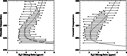
Figure 2.32 SAGE II versus NOAA-AL Lyman-a H2O measurements on board the ER-2. (a) Dotted curve: Lyman-a average profile over Punta Arenas (53° S, 71° W): Solid curve: SAGE II monthly zonal mean for 50° S-60° S, September 1987. The horizontal bars represent data range (in situ measurements) and standard deviations (1s) (SAGE II). (b) Dotted curve: Lyman-a average profile inside the vortex (near 72° S, 70° W). Solid curve: SAGE II monthly zonal mean for 60° S-70° S, September, 1987. The horizontal bars represent data range (in situ measurements) and standard deviations (1s) (SAGE II).
Comparison with balloon-borne frostpoint measurements
As discussed in Rind et al. [1993], in situ water vapour measurements using frostpoint hygrometer measurements have made significant contributions to the validation of SAGE II observed water vapour profiles. A more extensive investigation has recently been carried out to re-examine the intercomparison based on the complete set of the SAGE II archived water vapour data set (January 1986 through May 1991) and the whole catalogue of the NOAA-CMDL balloon-borne frostpoint data set released for this assessment activity.
Pairs of comparisons were selected using 1-day and 1000-km coincidence criteria. Coincident pairs include comparisons where one balloon profile is compared with several different SAGE II profiles. For the two middle latitude locations (Boulder, Colorado and Edwards AFB, California), there exist 36 and 15 coincident pairs respectively. The intercomparison at low latitudes (American Samoa) consists of 13 pairs while the comparison for southern high latitudes (McMurdo) consists of a much smaller size of samples (8 coincident pairs). The coincident pairs for Boulder include samples for various seasons and cover observations in four different years (1986, 1988, 1989 and 1990).
A summary of all the comparisons with NOAA-CMDL frostpoint measurements is shown in Figure 2.33. Average percentage differences (SAGE II-frostpoint) are given for all coincident pairs for Boulder, Edwards AFB, Samoa, and McMurdo. Systematic differences are seen (with SAGE II larger) above 21 km for middle latitude measurements (left panels). Differences increase upwards in the altitude range 21 to 27 km. There seem to be less significant differences in the opposite sense (SAGE II smaller) below 18 km. The large variability in the differences below 13 km (shown by the solid curves) reflects the steep vertical gradient and significant spatial inhomogeneities that exist in these altitude regions near the tropopause. Differences for measurements over Samoa (upper right panel) decrease upward in the altitude range 18 to 26 km. However, one should note that the points below 18 km and above 25 km in this figure represent comparisons in July only (8 pairs), while the remaining data points are the average differences for all 13 cases (both July and January). For comparison over McMurdo (lower right panel), SAGE II and NOAA-CMDL frostpoint measurements overlap only in a smaller altitude range (12 to 22 km). Since all 8 cases that contribute to this figure are measurements in October, the increasing differences with decreasing altitude below 16 km could be attributed to spatial inhomogeneities due to vortex activity during austral spring in the southern high latitude region. In general, above 20 km differences are less than 20%, with SAGE II larger. Below 20 km, the sign changes for the middle and high latitude comparisons, and the magnitude increases.
Comparisons were also made with the LMD frostpoint hygrometer. These intercomparisons are described by Pruvost et al. [1993]. Comparisons were made for balloon flights from Aire sur l’Adour, France, in October 1987, 1989, and 1990. In terms of percentage differences, the discrepancies are 12% or less, with SAGE II larger.
It should be noted that a new version (6.0) of the SAGE II water vapour retrieval was released during the summer of 2000, too late to be used in this assessment. A validation paper has not yet been published, but major changes are expected. Changes incorporated into the SAGE II v6.0 inversion algorithm that affect the water vapour retrieval are:
1) An improved position registration algorithm that will change the transmission profile computation.
2) Correction of the 453 nm channel drifts, which affected the NO2 retrieved values.
3) Update of the 600 nm aerosol estimation algorithm, which will affect the 525 nm aerosol values used in the 940 nm aerosol estimate.
4) Use of the 1992 compilation of line parameters for water vapour at the 940 nm region.
5) Update of the ozone absorption cross section at the 940 nm region.
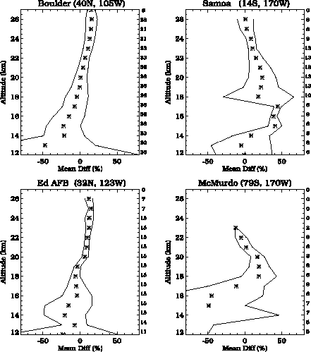
Figure 2.33 Overall percentage differences [SAGE II minus in situ] for comparisons with the NOAA-CMDL frostpoint over Boulder, Edwards AFB, Samoa, and McMurdo. The solid curves represent the standard deviation (1s) at each altitude and the numbers on the right indicate the number of valid pairs of comparison at each altitude.
2.3.4 ATMOS comparisons
Lyman-a hygrometers
Measurements made at the beginning of the Atmospheric Laboratory for Applications and Science-3 (ATLAS-3) mission nearly overlapped in time and location with observations made from the ER-2 during the Airborne Southern Hemisphere Ozone Experiment/Measurements for Assessing the Effects of Stratospheric Aircraft (ASHOE/MAESA) aircraft mission. A previous comparison of observations made with the NOAA-AL Lyman-a hygrometer during ASHOE/MAESA with Version 2 retrievals of H2O from ATMOS/ATLAS-3 demonstrated differences smaller than 8% [Chang et al., 1996].
The ATLAS-2 mission also provided an opportunity to compare ATMOS observations with those from the NOAA-AL Lyman-a hygrometer. Between 8 and 16 April 1993, ATMOS made observations at northern high latitudes inside and outside the Arctic vortex. In the few weeks following this mission, between 23 April and 18 May, the NOAA-AL instrument flew at northern middle latitudes aboard the ER-2 as part of the SPADE aircraft campaign. Between the ATLAS-2 and SPADE missions (20 April), the Arctic vortex broke into large fragments, which were encountered by the ER-2 during Stratospheric Photochemistry Aerosols and Dynamics Expedition (SPADE). A comparison of SPADE and ATMOS data revealed small differences between ATMOS (Version 2) retrievals of H2O inside and outside the vortex and NOAA-AL H2O measurements inside and outside vortex fragments, as long as the distinction between these air masses was taken into account [Michelsen et al., 1999a].
The left panels of Figure 2.34 show a similar analysis to that of [Michelsen et al., 1999a] using ATMOS Version 3 observations. The in situ data were sorted into several categories based on the relative abundance of long-lived tracers: measurements in vortex fragments, those in air influenced by the vortex and/or tropics, and those in middle latitude (apparently unperturbed by vortex or tropical) air (see Michelsen et al. [1999a] for more details about the sorting procedure). The in situ observations made in vortex fragments by the NOAA-AL instrument are compared with ATMOS observations from inside the vortex in the top panel. The NOAA-AL measurements in air masses influenced by the tropics and/or vortex are compared with ATMOS data from outside the vortex. Since ATMOS only measured at high latitudes and did not appear to sample air with tracer characteristics completely unperturbed by the vortex, a comparison is not shown for the middle latitude case. The data are plotted relative to N2O. For the in situ observations, N2O was provided by ALIAS [Webster et al., 1994]. The error bars in all panels represent the weighted standard deviation of the weighted mean. The percent differences are plotted in the lowest left panel of Figure 2.34, which shows that the ATMOS measurements are 0-4% greater than those provided by the NOAA-AL Lyman-a hygrometer for this case. An indirect comparison where both the NOAA-AL Lyman-a and ATMOS are compared to HALOE suggests that the NOAA-AL Lyman-a is ~5% greater than ATMOS, which is somewhat different than shown by the direct comparison.
The Harvard Lyman-a hygrometer also flew during SPADE, and the right panels of Figure 2.34 show the corresponding comparison of ATMOS data with measurements from the Harvard instrument made simultaneously with those from the NOAA-AL instrument. This analysis demonstrates that the ATMOS measurements are systematically smaller than the Harvard observations by 11-16% for comparisons with the SPADE data set.
Figure 2.35 presents comparisons of potential water (2¥CH4+H2O) derived from simultaneous measurements of H2O and CH4 for the same ATMOS occultations and ER-2 flights as those shown in Figure 2.34. For the ER-2 observations, CH4 was provided by ALIAS [Webster et al., 1994]. Observations of CH4 from this instrument have an estimated (1s) accuracy of ±5% and have been shown to be consistent with ATMOS Version 3 observations to within 5% [Michelsen et al., 1999b]. ATMOS observations of CH4 have an estimated (1s) accuracy of ±5% and precision of ±5% [Abrams et al., 1996a].
Measurements from each of the instruments demonstrate that potential water is constant within experimental uncertainty outside the vortex (Figures 2.35b and 2.35e). Comparison of Figures 2.35a and 2.35b demonstrates that potential water based on the ATMOS observations is approximately 0.4 ppmv less inside the vortex than outside.
This difference in potential water between vortex and extra-vortex air is smaller than the 0.7 ppmv difference noted in a previous analysis based on ATMOS Version 2 data [Michelsen et al., 1999a]. The NOAA-AL Lyman-a hygrometer yields a mean difference of 0.1 ppmv, whereas the Harvard Lyman-a hygrometer suggests that potential water is 0.1 ppmv larger inside than outside vortex fragments. Given an average upward trend in potential water of ~0.07 ppmv/yr (see section 2.5.3), potential water inside the vortex is expected to be smaller than extra-vortex values by at least 0.1 ppmv in the absence of dehydration by PSC sedimentation. As summarised in Figures 2.35c and 2.35f, values of potential water based on ATMOS data are 0-5% larger than those derived from NOAA-AL Lyman-a hygrometer data and 6-12% smaller than values derived from Harvard Lyman-a hygrometer data.
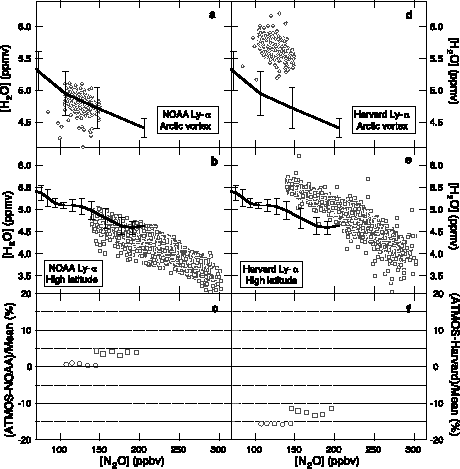
Figure 2.34 Comparison of ATMOS Version 3 retrievals of H2O with Lyman-a hygrometer observations from the SPADE ER-2 aircraft campaign. The volume mixing ratio of H2O is plotted relative to the mixing ratio of the long-lived tracer N2O. ATMOS observations are compared with measurements from the NOAA-AL instrument in the left panels and with measurements from the Harvard instrument in the right panels. Symbols represent the in situ observations, and lines represent weighted averages of ATMOS profiles with error bars showing the weighted standard deviation (1s) of the weighted mean. The SPADE observations are sorted into 3 categories, as described by Michelsen et al. [1999a]. (a) and (d) SPADE data associated with vortex fragments are compared with ATMOS observations made during ATLAS-2 inside the Arctic vortex before it broke up. (b) and (e) SPADE data characterised as being influenced by vortex and/or tropical air are compared with ATMOS/ATLAS-2 data recorded outside the Arctic vortex. (c) and (f) The percent differences between the ATMOS observations and those from the NOAA-AL instrument (c) and the Harvard instrument (f) are plotted as a function of N2O for the vortex case (circles) and the vortex (or tropics) influenced case (squares). For the in situ data, simultaneous observations of N2O were provided by ALIAS.
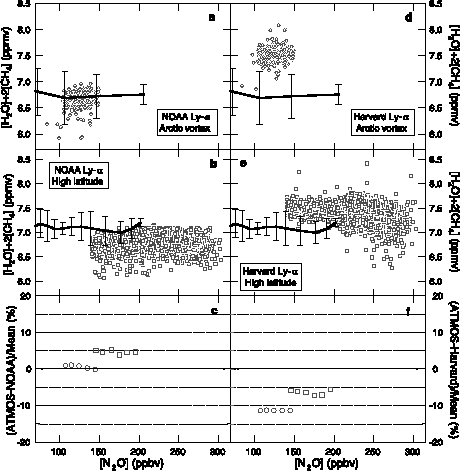
Figure 2.35 Comparison of ATMOS Version 3 values for 2![]() CH4+H2O with observations from the SPADE ER-2 aircraft campaign. Potential
water 2
CH4+H2O with observations from the SPADE ER-2 aircraft campaign. Potential
water 2![]() CH4+H2O is plotted relative to the volume mixing ratio of the long-lived
tracer N2O. ATMOS observations are compared with potential water derived
from ALIAS CH4 with NOAA-AL H2O in the left panels and with Harvard H2O in the right panels plotted against ALIAS N2O. Symbols represent the in situ observations, and lines represent weighted averages of ATMOS
profiles with error bars showing the weighted standard deviation
(1s) of the weighted mean. The SPADE observations are from the same
flights shown in Figure 2.34. (a) and (d) SPADE data associated
with vortex fragments are compared with ATMOS observations made
during ATLAS-2 inside the Arctic vortex before it broke up. (b)
and (e) SPADE data characterised as being influenced by vortex
and/or tropical air are compared with ATMOS/ATLAS-2 data recorded
outside the Arctic vortex. (c) and (f) The percent differences
between the ATMOS observations and those from the NOAA-AL instrument
(c) and the Harvard instrument (f) are plotted as a function of
N2O for the vortex case (circles) and the vortex (or tropics) influenced
case (squares).
CH4+H2O is plotted relative to the volume mixing ratio of the long-lived
tracer N2O. ATMOS observations are compared with potential water derived
from ALIAS CH4 with NOAA-AL H2O in the left panels and with Harvard H2O in the right panels plotted against ALIAS N2O. Symbols represent the in situ observations, and lines represent weighted averages of ATMOS
profiles with error bars showing the weighted standard deviation
(1s) of the weighted mean. The SPADE observations are from the same
flights shown in Figure 2.34. (a) and (d) SPADE data associated
with vortex fragments are compared with ATMOS observations made
during ATLAS-2 inside the Arctic vortex before it broke up. (b)
and (e) SPADE data characterised as being influenced by vortex
and/or tropical air are compared with ATMOS/ATLAS-2 data recorded
outside the Arctic vortex. (c) and (f) The percent differences
between the ATMOS observations and those from the NOAA-AL instrument
(c) and the Harvard instrument (f) are plotted as a function of
N2O for the vortex case (circles) and the vortex (or tropics) influenced
case (squares).
MkIV
Although ATMOS and the MkIV instrument have never made coincident observations, they have collected data in similar air masses. Comparisons between these data sets are shown in Figure 2.36. Figure 2.36a shows the mean of ATMOS data collected at southern middle latitudes during ATLAS-1 (25 March-2 April 1992) compared with MkIV observations from northern middle latitudes on 14 and 15 September 1992. Figure 2.36b shows data from a MkIV flight on 3 April 1993 at northern middle latitudes compared with the extra-vortex observations made by ATMOS during ATLAS-2 (8-16 April 1993) at high northern latitudes. The ATMOS data shown in this panel are the same as those shown in the second set of panels in Figure 2.34. Figure 2.36c shows a comparison of data from the MkIV at northern middle latitudes during fall 1993 (23 and 24 September) with observations from ATMOS at northern middle latitudes during ATLAS-3 in fall 1994 (3-14 November). Figure 2.36d shows the percent differences between the ATMOS and MkIV observations for the cases shown in the first three panels. These comparisons indicate that the ATMOS and MkIV measurements of H2O differ by less than 5% under similar atmospheric conditions when plotted relative to N2O.
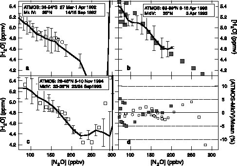
Figure 2.36 Comparison of ATMOS Version 3 retrievals of H2O with MkIV observations. The volume mixing ratio of H2O is plotted as a function of N2O. Symbols represent the MkIV observations, and lines represent weighted averages of ATMOS profiles with error bars showing the weighted standard deviation (1s) of the weighted mean. (a) ATMOS observations made during ATLAS-1 at southern midlatitudes are compared with MkIV measurements from northern midlatitudes on 14 and 15 September 1992. (b) ATMOS observations made during ATLAS-2 outside the Arctic vortex are compared with MkIV measurements from northern midlatitudes on 3 April 1993. (c) ATMOS observations made during ATLAS-3 at northern midlatitudes are compared with MkIV measurements from northern midlatitudes on 23 and 24 September 1993. (d) The percent differences between the ATMOS observations and those from the MkIV are shown for the 3 cases; symbols correspond to those used in (a)-(c).
MkIV also measures CH4 with an accuracy (1s) of ±5% [Toon et al., 1999]. A comparison between MkIV and ATMOS values of potential water for the cases shown in Figure 2.36 is presented in Figure 2.37. The difference is within 5% (3% in the middle stratosphere) and is similar to that shown for the H2O comparisons. The small differences are expected given the similarity of the MkIV and ATMOS instruments and their data reduction methods. This demonstrates that the selection criteria employed for these comparisons is valid, particularly given that the data shown in Figures 2.36 and 2.37 were separated by a much greater time period than any of the data sets used in the other comparisons presented.
For the cases presented here, ATMOS Version 3 water vapour observations are within 0-4% of measurements from the NOAA-AL Lyman-a hygrometer and MkIV instruments. The ATMOS observations are 11-16% dryer than those from the Harvard Lyman-a hygrometer for comparisons with measurements made in April and May 1993. These results are consistent with comparisons of potential water (2¥CH4+H2O) derived from NOAA-AL, Harvard, MkIV, and ATMOS water vapour measurements, and show that in general the direct comparisons of water vapour mixing ratios between sensors do a reasonable job of representing the differences.
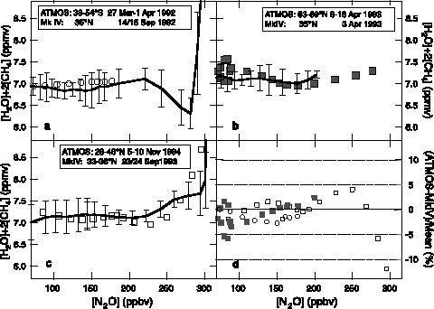
Figure 2.37 Comparison of ATMOS Version 3 values for 2![]() CH4+H2O with MkIV observations. Potential water 2
CH4+H2O with MkIV observations. Potential water 2![]() CH4+H2O is plotted as a function of N2O. Symbols represent the MkIV observations, and lines represent
weighted averages of ATMOS profiles with error bars showing the
weighted standard deviation (1s) of the weighted mean. (a) ATMOS observations made during ATLAS-1
at southern mid-latitudes are compared with MkIV measurements
from northern mid-latitudes on 14 and 15 September 1992. (b) ATMOS
observations made during ATLAS-2 outside the Arctic vortex are
compared with MkIV measurements from northern mid-latitudes on
3 April 1993. (c) ATMOS observations made during ATLAS-3 at northern
mid-latitudes are compared with MkIV measurements from northern
mid-latitudes on 23 and 24 September 1993. (d) The percent differences
between the ATMOS observations and those from the MkIV are shown
for the 3 cases; symbols correspond to those used in (a)-(c).
CH4+H2O is plotted as a function of N2O. Symbols represent the MkIV observations, and lines represent
weighted averages of ATMOS profiles with error bars showing the
weighted standard deviation (1s) of the weighted mean. (a) ATMOS observations made during ATLAS-1
at southern mid-latitudes are compared with MkIV measurements
from northern mid-latitudes on 14 and 15 September 1992. (b) ATMOS
observations made during ATLAS-2 outside the Arctic vortex are
compared with MkIV measurements from northern mid-latitudes on
3 April 1993. (c) ATMOS observations made during ATLAS-3 at northern
mid-latitudes are compared with MkIV measurements from northern
mid-latitudes on 23 and 24 September 1993. (d) The percent differences
between the ATMOS observations and those from the MkIV are shown
for the 3 cases; symbols correspond to those used in (a)-(c).
2.3.5 ILAS comparisons
During the eight-month period of operation of the ADEOS satellite, balloon validation experiments were conducted at two high latitude sites. For the validation of ILAS water vapour measurements, five instruments using different techniques and described in this report, made balloon-borne correlative measurements from February until May 1997. These comparisons are listed in Table 2.1.
Table 2.1. Balloon flights for validation of the ILAS experiment. The LMD frostpoint, FISH, and MIPAS instruments were launched from Kiruna, Sweden (68°N, 21°E); the MkIV and FIRS-2 instruments were launched from Fairbanks, Alaska (65°N, 148°W).
|
|
|
|
|
|
| LMD FP | 14 Feb 1997 | 68.7°N, 41.0°E |
|
|
| FISH | 11 Feb 1997 | 68.4°N, 17.9°E |
|
|
| MIPAS | 24 Mar 1997 | 68.9°N, 34.5°E |
|
|
| MkIV | 08 May 1997 | 62.2°N, 142.1°W |
|
|
| FIRS-2 | 30 Apr 1997 | 63.6°N, 149.3°W |
|
|
1Distance between balloon measurement and 20 km tangent point: 150 km
The operational data processing software was developed at NIES in Japan [e.g. Yokota et al., 1998]. In this assessment, the most recent complete release of data products (Version 4.20) is used. Comparisons using earlier retrievals are found in Sasano et al. [1999]. The relatively recent release of these data products limits the validation for this report to a relatively straightforward comparison of near-coincident profiles without detailed examination of possible dynamical effects.
Figure 2.38 shows the percentage difference of water vapour measurements for the five ILAS validation flights given at satellite data altitudes. Positive values denote ILAS values greater than those of the correlative measurement. On 14 February, LMD frostpoint measurements were available from 22 to 27 km. At the highest altitude, the difference is less than 10%, but for the lower altitudes, ILAS data are up to 28% larger than the LMD frostpoint data. These measurements were obtained near the edge of the polar vortex. A few days earlier from the same site, the Jülich Lyman-a hygrometer (FISH) obtained data very close to an ILAS measurement. Both profiles were obtained inside the polar vortex near its edge. At 15-19 km the difference was -2 to +12%, increasing with altitude. A similar result was found for the intercomparison of ILAS with the remote-sensing measurements by MIPAS on 24 March. In general, these high latitude winter measurements may be affected by atmospheric variability or different viewing geometries. The tangent altitudes of an ILAS profile correspond to different latitudes, while the in situ measurements were made more or less at a single latitude. The viewing geometry of MIPAS is such that it looks in the opposite direction to ILAS. The variability of water vapour abundance near the vortex edge is a plausible explanation for the observed altitude dependent differences between the measurements and limits the conclusions that can be drawn from this set of comparisons.
The validation flight on 8 May of the MkIV IR spectrometer yields differences between ?5 and +5% in the 18-31 km altitude range increasing up to +10% at lower altitudes. The FIRS-2 spectrometer was flown on 30 April up to an altitude of 40 km. The difference from 15-33 km was found to be -4% to +10%. Differences of ILAS data with both MkIV and FIRS-2 measurements do not indicate a clear altitude dependence. Both balloon observations as well as the corresponding ILAS measurements were made in air masses that were not influenced by the vortex, which was still lingering over Northern Europe and Russia in early May 1997 [Toon et al., 1999]. Further, the viewing geometry of both instruments is similar to that of ILAS. Thus, the conditions were more favourable for an intercomparison than those at Kiruna. This may be the reason for smaller differences than those seen for the validation measurements by the LMD frostpoint, FISH and MIPAS, despite the larger distance between the ILAS and correlative observations at Fairbanks.
At altitudes above about 30 km, the ILAS profile retrievals show artificial oscillations between two adjacent levels that are most likely caused by the onion peeling routine in V4.20 (see Figure 2.38, MkIV and FIRS-2 panels). Consequently, it is recommended that high altitude data from the current retrieval version not be used. Making some allowance for the variable conditions near the edge of the polar vortex, it can be concluded that the ILAS water vapour measurements in the 15-30 km altitude range fall within about 10% of the correlative measurements from a variety of techniques.
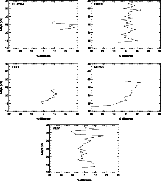
Figure 2.38 Percentage difference, (ILAS Version 4.20?validation measurement)/mean, for the five ILAS validation flights detailed in Table 2.1.
2.3.6 Upper stratosphere comparisons (WVMS and WASPAM)
An intensive period of stratospheric and mesospheric water vapour measurements occurred during the NASA ATLAS Spacelab shuttle missions in the early 1990’s. During the March-April flights in 1992 and 1993, middle atmospheric water vapour data are available from the HALOE and MLS satellite instruments aboard UARS, and from the MAS and ATMOS instruments aboard ATLAS on the shuttle. In addition, there are ground-based retrievals available from the Water Vapour Millimeter-wave Spectrometer (WVMS) instrument, which made measurements from Table Mountain, California (34.4ºN, 242.3ºE) during 1992 and from Lauder, New Zealand (45.0ºS, 169.7ºE) during 1993. During the ATLAS-2 mission in 1993, measurements coincident with the Lauder site are available from three of the satellite instruments, while HALOE measurements are available several days later. Figure 2.39 shows nearly coincident water vapour profiles from all five instruments. No correction has been applied for the different sensitivity and altitude resolution of the five instruments, and the WVMS retrievals are limited to altitudes above ~3 hPa. All of the measurements show an increase up to ~1 hPa, a relatively flat region from 1 to 0.1 hPa with a peak mixing ratio of between 6 and 7 ppmv, and a sharp drop above 0.1 hPa. At altitudes below 0.1 hPa, the measurements all agree to within 1 ppmv. The range is slightly larger above this altitude, but the differences in resolution and sensitivity are largest in the upper mesosphere both because of the large gradient with altitude and because of decreasing signal to noise. Similar figures for all three ATLAS missions, albeit with older retrieval versions, are given by Nedoluha et al. [1997].
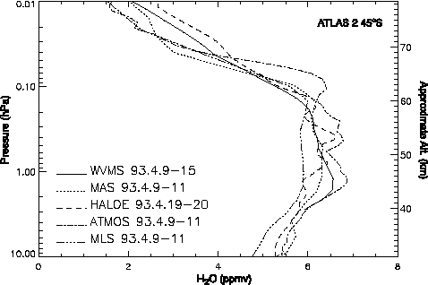
Figure 2.39 A comparison of zonal average water vapour mixing ratios retrieved during the ATLAS-2 mission in 1993 from MAS (V20, April 9-11), ATMOS (V3, April 9-11), MLS (V0104, April 9-11), HALOE (V19, April 19-20), and WVMS1 (V99, April 9-15).
In Figure 2.40, a comparison is shown of average coincident WVMS and HALOE retrievals for each of the NDSC sites where WVMS measurements are available. The coincidence criteria for the HALOE retrievals are ± 7 days, ± 30º longitude, and ± 5º latitude of the WVMS observation, which is generally obtained from a spectral integration covering ~1 week (see section 1.2 for more details).
In order to take into account differences in the resolution and sensitivity of the WVMS and HALOE instruments, we have convolved the HALOE data with the averaging kernels calculated for the WVMS instrument. The WVMS and HALOE instruments agree to within 1 ppmv at all altitudes, but there are biases apparent between the water vapour profiles retrieved by the ground-based and HALOE instruments. The difference between the WVMS and HALOE profiles generally peaks near 60 km, and then decreases in the upper mesosphere. The peak in this difference coincides with the notch in the unconvolved HALOE profile near this altitude, as was noted in Nedoluha et al. [1999].
Additional profile comparison data are available from the WASPAM (Wasserdampf und Spurengasmessungen mit Mikrowellen) experiment, see Hartogh and Jarchow [1995], Jarchow [1998], and Seele and Hartogh [1999]. WASPAM and HALOE data have been compared for the periods from October 1994 until September 1995 (location; Max-Planck-Institute für Aeronomie, MPAe, Germany, 51.66ºN, 10.13ºE) and from January until December 1998 (location; ALOMAR observatory, Andoya, Norway, 69.29ºN, 16.03ºE). The coincidence criteria for the HALOE retrievals are ± 10° longitude and ± 5º latitude of the WASPAM observation. The WASPAM spectra have been integrated for 24 hours before retrieval; therefore, the time coincidence criterion is 1 day. In Figure 2.41 both the original HALOE data and the HALOE data convolved with the averaging kernels of WASPAM have been plotted. While the convolved 69ºN data agree within 1 ppmv for all altitudes, the differences at 51ºN show a distinct peak of about 1.5 ppmv at 60 km, qualitatively consistent with the peak shown in the Table Mountain middle latitude comparison shown in Figure 2.40.
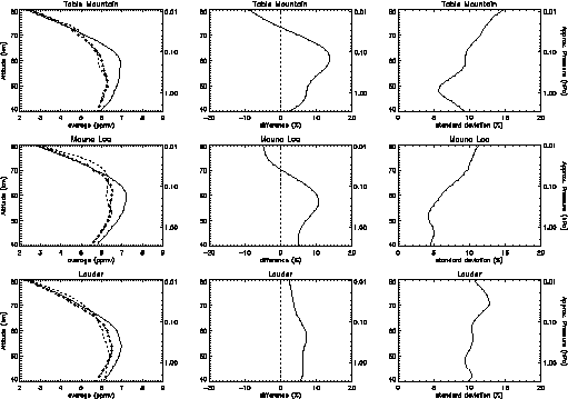
Figure 2.40 A comparison of average coincident water vapour retrievals from the WVMS instruments and HALOE. Column 1: Average of WVMS retrievals (solid), average of HALOE retrievals (dotted), average of convolved HALOE retrievals (dotted with crosses). Column 2: Difference of WVMS and HALOE retrievals (solid), and after convolution of the HALOE retrievals (dotted). Column 3: Standard deviation (1s) of the WVMS-HALOE difference (solid), and after convolution of the HALOE retrievals (dotted).
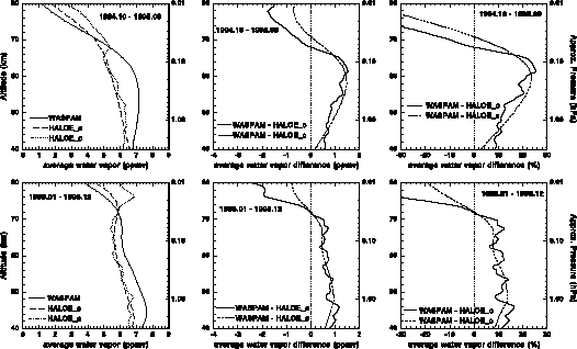
Figure 2.41 Comparison of average coincident water vapour retrievals from the WASPAM and HALOE instruments. Column 1: Average of WASPAM retrievals (solid), average of HALOE retrievals (dotted) and of convolved HALOE retrievals (dashed). Column 2: Difference of WASPAM and HALOE retrievals (solid) and after convolution of the HALOE retrievals (dashed). Column 3: Same as column 2 but difference in percent.
2.3.7 Comparisons with TOVS/HIRS
Radiosondes
The characteristics of radiosonde upper tropospheric water vapour observations are discussed in Chapter 1. The most comprehensive comparison between the upper tropospheric humidity (UTH) defined in Chapter 1 from the HIRS instrument on TOVS and radiosonde UTH was performed by Soden and Lanzante [1996]. They used the same HIRS clear column radiance data as described here but did not perform satellite-to-satellite intercalibration. For the period 1979-1991, they found the systematic differences in UTH between the HIRS and radiosondes showed a distinct geopolitical dependence that is a result of the different types of water vapour sensors used in different countries. For seasonal averages, they found RMS differences between satellite and radiosonde UTH of 10-12%, but this was reduced to about 6% when the radiosonde systematic bias was removed. A clear sky sampling bias exists in the HIRS UTH due to the requirement of clear or partly cloudy conditions. This clear sky sampling bias was estimated to be 4%. The radiosondes, however, have a spatial sampling bias because the radiosondes are concentrated over the Northern Hemisphere middle latitudes. Soden and Lanzante [1996] found that regionally, such as over the data sparse tropics, the radiosonde sampling bias could introduce systematic errors of 10-20%.
For individual matches with radiosondes and for layer-averaged specific humidity, the scatter between radiosondes and HIRS becomes much larger. For the layer 500-300 hPa, Scott et al. [1999] reported standard deviations (1a) of 35%, 46%, and 52% and biases of -1%, 15%, and 13% for HIRS-radiosonde matches in the tropics, middle latitudes, and polar regions. They found that the standard deviations between HIRS and radiosondes increased substantially with height, from about 22% in the layer 1000-850 hPa to 39% in the layer 500-300 hPa for all situations, reflecting the inaccuracy of the radiosonde observations at higher altitudes.
Operational numerical weather prediction centres, the National Centers for Environmental Prediction (NCEP) in the U.S, and the European Centre for Medium Range Weather Forecasting (ECMWF), have been directly assimilating HIRS radiance data for several years. Both centres report improved forecast skill using radiance data. In particular, ECMWF reports [McNally and Vesperini, 1996] that the HIRS upper tropospheric water vapour channel provides substantial positive impact to both water vapour and other aspects of the hydrological cycle prediction. Comparisons of HIRS UTH with these models are not presented since these models use the HIRS channel 12 radiance data and because the HIRS radiances are bias-adjusted at the numerical weather predictions centres to account for systematic differences between the models and the observations.
Improved radiosonde humidity detectors are being used and additional improvements are under development. These improvements are starting to have a positive impact on matches between satellite observations and radiosonde observations. Figure 2.42 shows a scatter plot of matches between the Vaisala RS80-H UTH and HIRS UTH for a research cruise in the eastern tropical Pacific Ocean for two months in 1997. Matches within 50 km and 3 hours show an RMS error of about 13% with a bias of 1.5%. Although the correlation is low (0.37), this error represents an improvement in the numbers quoted above for comparisons with archived radiosonde data sets. The relatively low correlation between the improved radiosonde moisture sensor UTH and HIRS UTH is partially a result of the limited range of humidity values that were compared, and highlights the difficulty in matching point measurements with the satellite data.
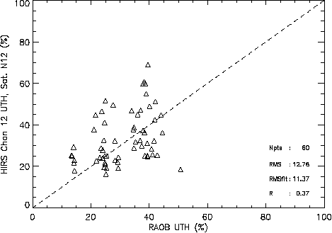
Figure 2.42 Scatter plot of UTH from the Vaisala RS80-H (H-Humicap sensor) radiosondes measured on a research cruise in the tropical Pacific and the HIRS UTH from the NOAA 12 satellite. Matches are taken to be within 50 km and 3 hours. The dashed line is a one-to-one line and not a fit to the data.
MOZAIC
A number of methods for comparing the HIRS and MOZAIC data were examined. These range from comparing individual MOZAIC flights with coincident HIRS individual swath data to comparing monthly mean, spatially averaged products. In all cases, the results are similar; the flight level MOZAIC data results in a much more heterogeneous sampling of the water vapour distribution than the volume-averaged data from HIRS. This is illustrated in Figure 2.43, which shows a comparison of the MOZAIC data and HIRS data. The data have been averaged into monthly mean, 2º latitude-longitude bins, and the HIRS data have only been sampled along the MOZAIC flight tracks. Shown are the monthly mean MOZAIC data, the HIRS satellite data, the absolute difference between the two, and a scatter plot of the two data sets. In the monthly mean images, the HIRS data have much smoother gradients then the MOZAIC data. The flight tracks, particularly across the equator to South America, Africa, and Southeast Asia, do have qualitatively similar gradients. The MOZAIC data, however, have much greater variability. These results are typical of all months analysed. For the months of June and July 1997, the correlations from the linear regression are 0.37 and 0.53 and the RMS differences are on the order of 20% of RH.
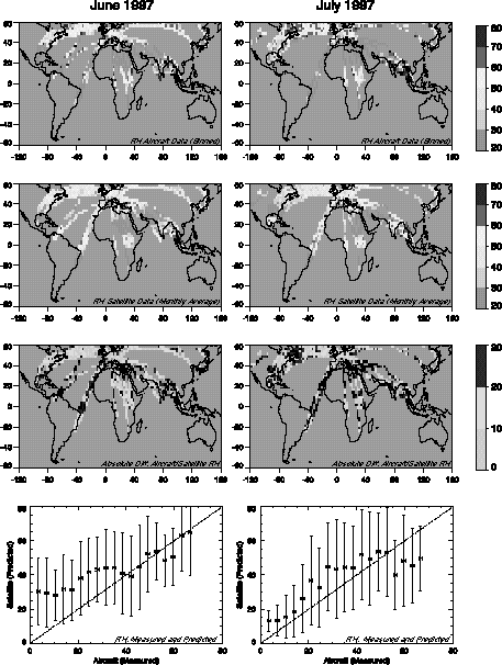
Figure 2.43 Comparison of the MOZAIC data and HIRS data that have been averaged into monthly mean, 2-degree latitude-longitude bins with the HIRS data only been sampled along the MOZAIC flight tracks. Shown are the monthly mean MOZAIC data, the HIRS satellite data, the absolute difference between the two, and a scatter plot of the two data sets.
2.3.8 MLS tropospheric comparisons
The MLS upper tropospheric humidity is compared with in situ measurements by frostpoint hygrometers, Vaisala radiosondes, and MOZAIC. The basis for assessing the quality of the MLS measurements is "coincident" comparisons. The in situ instrument suite considered here has incomplete global coverage and direct comparisons when both instruments sampled almost the same air provide the best results. Climatological or other average comparisons yielded larger differences, indicating differences in spatial and temporal sampling between these instruments are a dominant component of the measurement discrepancies noted between the instruments.
The MLS, a remote sensor, reports water vapour measurements that are an average over a volume 100¥100¥3 km3 (surface by height). The MLS forward model includes vertical but not horizontal gradients, hence there will be additional errors. The MLS measurement is not necessarily a simple volume average. The other techniques used here for validation measure water vapour in situ and give a one-dimensional string of data (vertically in the case of frostpoint and radiosondes and horizontally for MOZAIC). Nevertheless, with a sufficient number of coincidences it should be possible to determine the measurement biases between MLS and the other techniques.
Coincidences between MLS and the other techniques are found and their measurements are compared in a scatter plot. A simple linear fit with a correlation factor is computed for the fit. The correlation is a measure of how well the two measurement systems track each other. Random measurement noise tends to reduce the number toward zero, as will spatial and temporal atmospheric variability. Using the theoretical precision estimates for MLS (the random noise component), one would expect to get roughly 0.9, 0.9, 0.9, 0.6 correlation for 147, 215, 316, and 464 hPa levels. The MLS data can be used to estimate its de-correlation over distance, but this will include random noise as well. The MLS makes measurements approximately every 450 km. The correlation of the data with itself 4º later is 0.85, 0.62, 0.47, and 0.43 for 147, 215, 316 and 464 hPa respectively. Time coincidence is harder to measure for MLS because orbit repeats take five days. Twenty-four hours later, the orbit is shifted 5º in longitude and zero in latitude. At the four levels and 1 day later, the correlations are 0.67 at 147 hPa, 0.58 at 215 hPa, 0.44 at 316 hPa, and 0.38 at 464 hPa. These values, including a 5º spatial (longitude) difference, are only slightly worse than spatial de-correlation.
NOAA-CMDL balloon frostpoint hygrometer comparisons
The NOAA-CMDL frospoint hygrometer measures the frostpoint temperature and is considered accurate to 10% (section 1.1.1). The data are available at 250 m intervals and are converted to relative humidity over ice for the comparisons. Data from Boulder, Colorado (40ºN, 105ºW), Hilo, Hawaii (19ºN, 155ºW), Lauder, New Zealand (45ºS, 169ºE), McMurdo, Antarctica (77ºS, 166ºE) and the Central Equatorial Pacific Experiment (CEPEX) were available for this assessment. There are limited NOAA-CMDL frostpoint hygrometer data available, and for the purposes of comparison, coincidence criteria of 5.0º, 3.0º, and 6.0 hours for longitude, latitude, and time are used. This produces 16 unique hygrometer profiles for comparison.
Figure 2.44 shows a summary scatter plot between MLS and the NOAA-CMDL hygrometer with a best-fit line through the points. The data at 316 and 464 hPa levels were screened for bad retrieved values. There are more than 16 points per level because sometimes MLS had two or more measurements coincident with the frostpoint measurement. The higher resolution frostpoint data was averaged vertically with an MLS averaging kernel function to give a better estimate of what MLS should measure. The linear correlation coefficients for each level are consistent with that expected for this degree of coincidence at all levels.
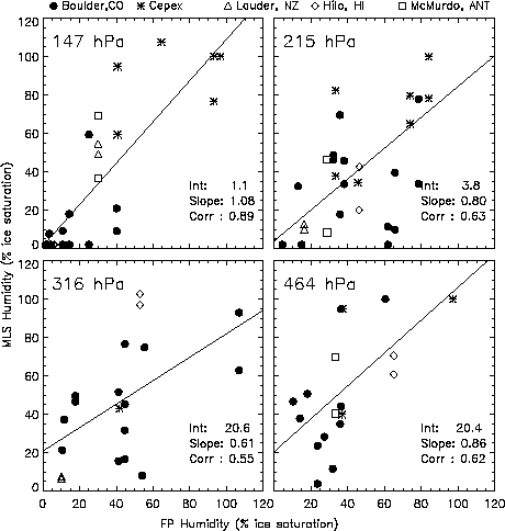
Figure 2.44 Scatter plot summary of all the MLS and NOAA-CMDL frostpoint hygrometer coincidences. The slope and correlation coefficient are supplied.
Operational radiosondes
The global radiosonde network provides a rich supply of coincidence opportunities. The data are archived into files binned by Universal Time (UT) in six-hour increments (00, 06, 12, and 18 UT) for each day. Data for the entire UARS mission are available from the UARS Central Data and Handling Facility. Reporting stations are required to provide data (when available) on pre-defined mandatory levels (1000, 850, 700, 500, 400, 300, 250, 200, 150~hPa, and several levels above). The data on these levels are used in this analysis. Data on intermediate significant levels are also supplied, but for data processing simplicity, the intermediate data are not used. Relative humidity is archived as dew point depression. The dewpoint data are converted to water vapour pressure using the Wexler expression in [Elliott and Gaffen, 1991]. Water vapour pressure is converted to ice relative humidity (RHi) or mixing ratio based on the Goff-Gratch expression for ice saturation vapour pressure [List, 1949] using the radiosonde temperature measurement.
Several radiosonde types are used around the world. Based on the characteristics of the humidity sensors as discussed in Chapter 1, for MLS validation purposes only the Vaisala radiosonde is used. The Vaisala Humicap detector comes in three versions, RS-80 A, H, and RS-90. The A-sensor has been in use the longest, but at temperatures colder than about -30ºC has a significant dry bias [Miloshevich et al., 2000; also see section 2.2.3]. The RS80-H and RS-90 significantly correct this problem. The archived sonde files do not indicate which of these types are used; however, widespread use of the H and RS-90 types only started to be implemented in 1993 and 2000 respectively. For the 1991-1994 period considered here, only the A-sensor was in widespread use.
MLS made over 1300 measurements per day nearly daily from 1991 through 1994. Temporal coverage is intermittent thereafter. A coincidence is defined as 1º by 1º in latitude and longitude (or ~110 km2) and 3 hours UT. Tighter coincidence criteria than these are not appropriate given the horizontal smearing present in the MLS data. This provides more than 3000 coincidences for comparisons. A four-panel scatter plot of the radiosonde versus MLS coincident measurements with best-fit lines using two different fitting procedures is shown in Figure 2.45. The thinner solid line shows the fit for a linear regression that assumes that the error is in the dependent variable (in this case MLS). The thicker solid line shows the fit using orthogonal distance regression, assuming that there is error in both variables. A retrieval screen for the MLS data at 316 and 464 hPa levels used to remove suspicious data. The correlation coefficients are in the neighbourhood of 0.5-0.7. Despite the relatively good coincidence, the correlation values are smaller than expected, indicating other factors are probably more important than coincidence issues. The results of the linear regression and orthogonal distance regression are quite different, and it is difficult to come to any conclusion about the relationship between radiosonde and MLS humidity from this analysis. The low correlations are a factor making the data sensitive to the type of regression used.
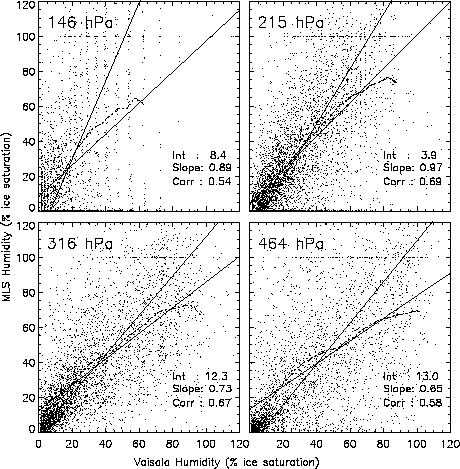
Figure 2.45 Scatter plot summary of all the MLS and Vaisala Humicap coincidences. The correlation coefficient and line fit parameters are annotated on the plot. The thin solid line is for the linear regression fit, the thick line for the orthogonal distance regression fit. The dashed dot line is a weighted smoothed average of the MLS values in 5 %RHi bins using the Vaisala measurements, indicating the linear regression fit is reasonable for these data.
MOZAIC
The European programme MOZAIC began in 1993. MOZAIC consists of automatic measuring equipment installed on five Airbus A340 aircraft in normal airline service (see section 1.1.5). Data was made available from August 1994 to May 1998. The same coincidence criteria were used as that for comparing radiosondes: 1º longitude, 1º latitude, and 3 hours. Normally, several MOZAIC flight track measurements fall within a single MLS coincidence. Potential vorticity between -2.0 and 2.0 from the European Centre for Medium-Range Weather Forecasts (ECMWF) analyses that is supplied with the data, and level flight path were used to screen the coincident MOZAIC data. The coincident flight path data (temperature, pressure, and relative humidity) were averaged to yield a single value for comparing with the MLS measurement. The units were converted to ice relative humidity using the World Meteorological Organisation (WMO) relative humidity function supplied with the data and the MOZAIC temperature measurement. The MLS water vapour value was obtained from linearly interpolating its profile to the average MOZAIC pressure. The MLS 316 hPa upper tropospheric humidity was not quality screened because it has a very minor impact and reduces the number of coincidences. This produced 461 coincidences that are shown as a scatter plot in Figure 2.46. For clarity, bars indicating MLS error (typically 10-30%) and MOZAIC along track variability (typically 20-30%) are omitted.
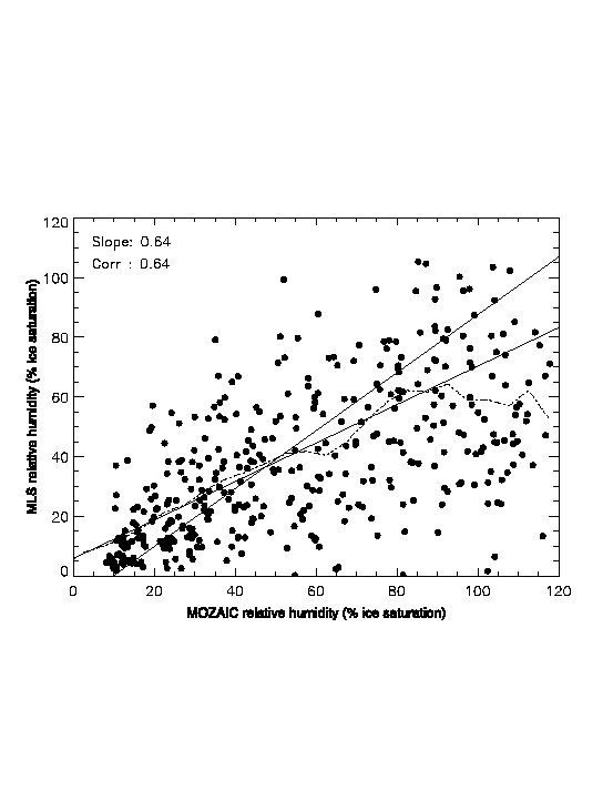
Figure 2.46 Scatter plot of coincident MOZAIC and MLS relative humidity measurements. The correlation coefficient and line fit parameters are annotated on the plot. The thin solid line is for the linear regression fit, the thick line for the orthogonal distance regression fit. The dashed dot line is a weighted smoothed average of the MLS values in 5% RHi bins using the MOZAIC measurements, indicating the linear regression fit is reasonable for these data.
The scatter between MLS and MOZAIC is considerable and comparable to the scatter seen when comparing radiosonde and frostpoint data to MLS. An important issue of course is that MOZAIC is a point vertical measurement whereas MLS has considerable vertical averaging. Also to be noted is that 77 out of 461 MOZAIC humidities are greater than 100%. As with the radiosonde data two fitting methods were applied to the data as shown in Figure 2.46. The fits were done to the 384 points where relative humidity is less than 100% is shown and gave a correlation of ~0.6. Again, the two different fitting methods give quite different results in the slope and intercept. The linear regression suggests that the MLS is drier than MOZAIC, but this is not clearly shown with the orthogonal distance regression fit. The typical MOZAIC measured atmospheric variability within the MLS footprint is consistent with the computed correlation factor. Including MOZAIC data greater than 100% RHi worsened the correlation significantly. For unknown reasons there is very poor correlation between MLS and MOZAIC RHi when the latter measures supersaturation.
The comparisons between MLS and the in-situ measurements do not provide strong constraints on the MLS data since they seem to be highly dependent on the fitting method that is used. Further work to understand these differences is needed.