1.4 Satellite sensors
Measurements of UT/LS water vapour radiances by satellite sensors are obtained within specific spectral absorption and/or emission bands or lines of this molecule. An early review of the various measurement approaches is given in Harries [1980]. The various instruments use spectral channels or frequencies in the UV/visible/near infrared (SAGE II, POAM), the middle infrared (HIRS, LIMS, ATMOS, HALOE, and ILAS), and microwave (MLS, MAS, SSMT2, AMSU-B) regions [Goody and Yung, 1989; Harries, 1996; Pickett et al., 1998; Rothman et al., 1998]. Retrievals of water vapour or relative humidity then rely on a detailed knowledge of its absorption cross section. So far, there are no satellite measurements using the far infrared region, which has an abundance of rotational water vapour lines and would be suitable for sounding the upper troposphere. Some instruments measure the absorption of solar energy by water vapour from direct sunlight passing through the limb of the atmosphere during a sunrise or sunset event (ATMOS, SAGE II, HALOE, POAM, ILAS), while others use the limb emission (LIMS, MLS, MAS) or nadir emission (TOVS) techniques.
The spatial and temporal resolutions afforded by the satellite sensors dictate the scientific utility of a given satellite data set. In general, these attributes are discussed in the following subsections or references therein. The Earth limb-view techniques provide good vertical resolution for the retrieved profiles. Their measurements are obtained in the manner of vertically-scanning a pencil beam across the horizon of the atmosphere. Information for a single profile represents a tangent layer integration over several hundred kilometres along the line of sight, while being much narrower in width and depth (a few kilometres). The effective length of the tangent path is shortened as the vertical resolution improves. More complete daily coverage must be obtained by a suitable interpolation of those scans across nearly a thousand kilometres in the zonal direction. Limb, solar-occultation measurements provide about thirty profiles of water vapour per day. The orbital inclination of the spacecraft determines whether these occultation measurements progress over (or sweep across) most of Earth’s latitude zones within a few weeks (SAGE II, HALOE) or are restricted to a narrower high latitude region (ILAS, POAM). A consequence of this measurement method is that it is difficult to find a meaningful coincidence between a satellite profile measurement and a correlative measurement unless it was carefully planned. The cross-track scanning, nadir-viewing TOVS measurements are based on radiances integrated over deeper layers of the atmosphere, providing much better coverage each day and with a horizontal resolution of tens of kilometres. The TOVS measurements of the upper troposphere are of particular value because they provide for both good horizontal resolution and daily coverage, revealing the effects of the synoptic-scale circulation on the water vapour field. Table 1.22 contains the information on coverage for each data set.
Chapter 2 contains intercomparisons of data sets having disparate spatial scales. For example, an in situ correlative measurement will be sensitive to the small spatial scales that the satellite measurement can only be integrating over. If coincidence in time is not so critical, one way to intercompare water vapour fields from two satellites is to Fourier analyse the profile data at a pressure, altitude, or potential temperature surface and then construct field values that are co-located with the correlative measurement. Alternatively, one can use another quantity, such as potential vorticity, to transform the satellite and correlative measurement spatially.
The parameter that defines the quality of relative variations within a satellite water vapour field is the data precision, which is defined as the random error for the retrieved profile. Accuracy is defined by the combination of the random and systematic errors. It is noted at this point that the term systematic error should often be thought of as an uncertainty because if a bias were truly known, one could correct for it in the data set. Nevertheless, we refer to biases or systematic effects as errors in this report. When assessing trends from a satellite data set, one is usually analysing its daily zonally-averaged field. This averaging reduces its random errors. The long-term changes in its systematic error components must be known in order to quantify any trend in water vapour. Therefore, the error assessments for the satellite data are given in terms of their random and systematic terms.
Sources of systematic error for each of the data sets depend on their specific measurement technique, but are generally dominated by uncertainties in spectral parameters and/or on the stability and knowledge of the instrument pointing. While these potential biases should not be affecting trends, any changes of the smaller biases are harder to characterise. For example, the long-term stability of the measured radiances or transmittances must be traced back to the instrument calibration. In addition, all satellite techniques must either account for the effects of clouds and heavy aerosol or at least mitigate their presence spectrally, especially as one begins to view the upper troposphere. Nevertheless, for those altitude regions where the measurement signal-to-noise (S/N) is high, all of the satellite data sets in this report have good precision (small random measurement error) and should provide for large-scale water vapour distributions that are qualitatively believable.
Although each instrument was carefully characterised and calibrated prior to flight, all experiments employ some onboard calibration or at least provide some information on long-term changes in instrument health as part of their operational mission parameters. Nevertheless there can be long-term instrument degradation or atmospheric effects (for example, decay of interfering volcanic aerosols) that may not be known very well - potentially affecting the accuracy of a time series of the retrieved water vapour. The interpretation of data time series obtained from several successive instruments (e.g., TOVS on operational satellites) must also consider instrument-to-instrument calibration uncertainties. The following subsections contain estimates of measurement and retrieval errors for individual water vapour profiles, as well as some discussion of effects that could impart a false trend to a time series of those profiles. The TOVS, SAGE II, and HALOE data sets of Table 1.22 are potentially useful for trend study, and their descriptions are more extensive and focused on those sources of systematic error that could affect a trend analysis.
Table 1.22 Coverage and time spans for satellite data sets
|
|
|
|
|
| TOVS | global | 1979 -1999 (daily) | 200 hPa to 500 hPa |
| LIMS | 64S-84N | Oct 1978 -May 1979 (daily) | 1 h Pa to 100 hPa |
| SAGE II (solar occultation) |
60S-60N | Jan 1986-Jun 1991 | 3 hPa to cloud tops |
| ATMOS (solar occultation) |
specific latitudes each Shuttle mission |
Apr/May 1985, Mar/Apr 1992 Apr 1993, Nov 1994 |
0.01 hPa to 100 hPa |
| HALOE (solar occultation) |
70S-70N | Oct 1991 -Sep 1999 | 0.01 hPa to 200 hPa |
| MLS stratospheric | 34N-80S or 34S-80N per yaw cycle | Sep 1991 -Apr 1993 | 0.01 hPa to 100 hPa |
| MLS UTH | see MLS stratospheric | Sep 1991 - Sep 1994; intermittent thereafter | 147, 215, 316, 464 hPa |
| MAS | near-global range of latitudes per Shuttle mission |
Mar/Apr 1992, Apr 1993 Nov 1994 |
0.01 hPa to 50 hPa |
| ILAS (solar occultation) | 57N-73N, 64S-88S | Nov 1996 -Jun 1997 | 0.1 hPa to cloud tops |
| POAM III (solar occultation) |
54N-71N, 63S-88S | Mar 1998 -Sep 1999 | 3 hPa to cloud tops |
The experiments and data sets in this section are ordered according to when each instrument began operations. At the time of this report the TOVS, SAGE II, HALOE, and POAM instruments were still taking data. In some cases, major satellite instruments have provided water vapour data with good coverage each day (SAMS on Nimbus 7 and ISAMS and CLAES on the UARS spacecraft), but they are not part of this assessment because their measured distributions are not of value to the UT/LS region. Another reason for not including those results is because their data uncertainties are either large or not well characterised. Still, much has been learned from those particular approaches for measuring and retrieving water vapour, and that understanding is being applied to the design of next-generation satellite instruments and retrieval algorithms.
1.4.1 Operational satellite upper tropospheric humidity (UTH)
Infrared and microwave observations by polar-orbiting satellites
The TIROS Operational Vertical Sounder (TOVS) is a suite of instruments that has flown on the NOAA series of operational polar-orbiting satellites since late 1978. Each NOAA satellite provides nearly contiguous, global coverage of the Earth twice per day and there are normally two satellites operational observing the Earth every 6 hours. The TOVS consists of three instruments; the High Resolution Infrared Sounder (HIRS) for sounding temperature and moisture profiles, the Microwave Sounding Unit (MSU) for sounding temperature profiles, and the Stratospheric Sounding Unit (SSU) for sounding temperature profiles. Although the TOVS instruments were designed for quantitative use to provide temperature and moisture sounding input into numerical weather prediction models, the long-term, global coverage provided by TOVS has become an important source of observational data for climate monitoring [NRC, 2000].
The HIRS is a twenty channel infrared filtered radiometer that includes three channels for measuring water vapour in the lower, middle, and upper troposphere. Since the HIRS is a filter radiometer, the upper tropospheric water vapour channel that measures upwelling radiation in the 6.5 micrometer region is sensitive to a broad atmospheric layer from about 200-500 hPa . The spatial resolution of the HIRS is about 25 km at nadir and decreases to about 40 km at the end of the scan. Calibration through the entire optics of the HIRS instrument is performed every 40 scan lines by viewing Space and an internal calibration target [Smith et al., 1979]. There are usually two NOAA polar-orbiting satellites operational at any time, thus providing data four times per day globally in cloud-free and up to approximately 70% in partially cloudy regions. There are three upper tropospheric water vapour products, each with relative advantages and disadvantages, that are discussed here: (1) use of upper tropospheric water vapour channel radiances (brightness temperatures), (2) a simple retrieval of upper tropospheric humidity (UTH), and (3) a complete inversion of all HIRS/MSU channels to obtain temperature and moisture profiles.
Infrared upper tropospheric water vapour channels are also used on the geostationary satellites and these channels are very similar to the HIRS. The METEOSAT spacecraft was the first to carry such a channel. The sounder on the GOES satellites also carried an upper tropospheric water vapour channel. These early channels on the geostationary satellites were intended for semi-quantitative work and on-board calibration was not always possible. Efforts are now underway to intercalibrate the upper tropospheric water vapour channels, in order to compile a climatology from the geostationary satellites.
More recently, microwave water vapour sounders have begun to fly on the operational polar-orbiting satellites of both the Defense Meteorological Satellite Program (DMSP, the SSMT2 instrument) and NOAA (the AMSU-B instrument). These microwave instruments produce measurements of layer-mean upper tropospheric water vapour similar to HIRS, but have the advantage of extending into cloudy, non-precipitating atmospheres. The first SSMT2 instrument began flying in April 1993, and there has been nearly continuous coverage from a single DMSP satellite since then. There is as yet, however, no climatology compiled from these data. The first AMSU-B instrument on the NOAA series satellites began operating in June 1998, and all future NOAA satellites will carry the AMSU-B in addition to the HIRS. Unfortunately, this first AMSU-B instrument on the NOAA-15 spacecraft has been plagued by instrument noise problems.
The data set of HIRS infrared radiance and upper tropospheric humidity (UTH) available for this assessment is derived from the clear column radiance (CCR) data set produced by NOAA NESDIS. (Future updates of the data will be produced from lower level data from the TOVS radiance pathfinder project.) The CCR brightness temperature data are subject to extensive quality control and binned into grids of 2.5 degrees latitude-longitude and time averages of 5 day and monthly means [Bates and Jackson, 1997; Bates et al., 1996]. Table 1.23 describes the characteristics of this data set. There are numerous possible sources of both random and systematic error involved in the production of this data set and these are discussed in detail in the references. The accuracy figure in Table 1.23 refers to the random errors associated with instrumental noise, an angular correction to nadir, the cloud clearing, and the averaging of at least 5 observations per grid box per month. In practice, each grid box contains substantially more than 5 observations per month (typically 50-100 per month), so the random error asymptotes to a lower threshold that depends upon the systematic error. The largest source of systematic error is due to the slightly different filter response function from the ten different instruments used over the twenty-year time period. Forward radiative transfer simulations are used to estimate these errors and have used an empirical method to adjust all instruments to a baseline instrument. The residual systematic error is estimated at less than 0.1K. The accuracy of these observations relative to other observations will be discussed in more detail in later chapters.
Table 1.23 Characteristics of the HIRS channel 12 upper tropospheric water vapour data set.
| Parameter | Character |
| technique | clear infrared emission near 6.5 micrometers |
| accuracy (random) | 1.11K (5 obs/month), 0.11K (100 obs/month) |
| accuracy (systematic) | 0.1K global/interannual |
| precision | 0.01K |
| time/space resolution | monthly, 2.5 degrees latitude-longitude |
| altitude range | 200-500 hPa. (varies with water vapour amount) |
| measured quantity | upwelling radiance |
| calibration procedure | on-board blackbody and cold space views |
A main advantage in the use of radiance data versus retrievals of UTH or temperature and moisture profiles is that the error characteristics for the radiances are much simpler than for the retrievals. This is a critical issue for the use of these data in both numerical weather prediction and in climate. In numerical weather prediction, the use of radiances, and particularly the use of upper tropospheric water vapour radiances in the tropics, has led to a large positive impact in forecasts . The use of radiances, however, requires highly accurate and very fast radiative transfer models for these regions of the spectrum. A recent intercomparison of radiative transfer models has demonstrated that this requirement has been met [Soden et al., 2000].
Sensitivity analysis
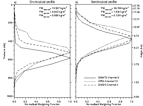
One way to visualise the sensitivity of water vapour sounding channels to the emission of radiation from typical temperature and moisture profiles is through the use of the weighting function. Figure 1.10 shows a comparison of the weighting functions for infrared water vapour channels for the HIRS channel 12 and a microwave water vapour channel of the SSMT2.
Figure 1.10 Comparison of normalised weighting functions for SSMT2 and HIRS for a dry (left) and a wet (right) tropical atmosphere.
A sensitivity analysis of the modelled HIRS and microwave (SSMT2 and AMSU-B) radiance or brightness temperature, TB, to changes in temperature and moisture profiles was carried out for the tropical profiles using a carefully sampled radiosonde data base, the Thermodynamic Initial Guess Retrieval . This involved two sets of analyses: (1) comparing simulated TB as a function of three vertical layer mean relative humidity (RH) values over oceans for 100-300 hPa, 300-500 hPa, and 500-1000 hPa, and (2) perturbing the temperature and moisture profiles in these three layers by a small amount in order to identify the differences in the sensitivity of HIRS and microwave instruments. Because the SSMT2 and HIRS water vapour channels are sensitive to both water vapour and temperature, the TB is more highly correlated to relative humidity than water vapour mixing ratio or overburden. All relative humidity perturbations were constrained between 0 and 100%. It should be noted that the relative humidity values were computed with respect to liquid water, as is the convention with radiosonde data. As a result, cold upper tropospheric temperatures can reduce the relative humidity maximum from 100% to as little as 70% due to saturation with respect to ice. The first two layers were chosen to quantify the sensitivity each instrument has at different levels of the upper troposphere.
The sensitivity of the SSMT2 and the HIRS TB to moisture and temperature perturbations is described here as the difference in TB from the perturbed case and the non-perturbed case {D TB = TB (perturbed)- TB(non-perturbed)}. Sensitivity analyses were performed by modifying the relative humidity field by 10% (holding temperature constant) and then by modifying the temperature field by 2K (holding specific humidity constant). These increments were chosen arbitrarily in order to illustrate the sensitivity differences between SSMT2 and HIRS and are not intended to explain observed differences in the SSMT2 and HIRS TB. Because the interest for climate studies is on systematic differences, random errors due to instrument noise were considered to be negligible when averaged over a large number of individual samples and are therefore ignored. Tables 1.24 and 1.25 summarise the results of the perturbation analysis for the two upper layers. As shown in these tables, the results are essentially symmetric for positive and negative perturbations in temperature, but not for changes in relative humidity. The SSMT2 has the strongest sensitivity to moisture perturbations and both instruments have a similar sensitivity to temperature perturbations. For a 10% increase in relative humidity in the highest levels (100 to 300 hPa) the SSMT2 TB drops by 4.90 K while the HIRS TB only drops by 3.71 K. The change for a 10% decrease in relative humidity, however, is even larger with a TB increase of 6.69 K for the SSMT2 and 6.41 K for HIRS.
The sensitivity of HIRS TB to the water vapour continuum effects was examined using the MODTRAN-3 spectral model. It was found that the continuum contribution to the TB was slightly dependent on latitude with a 1.61 K increase in temperature for the tropical profiles and a 1.15 K increase in temperature for the polar profiles.
Table 1.24 Modelled TB perturbations using tropical Thermodynamic Initial Guess Retrieval (TIGR)-2 profiles and perturbing the relative humidity profile by ±10%. The scatter plot summary statistics between SSMT2 and HIRS channel 12 (H12) TB are given in the columns slope, mean diff., and rms. diff. D TB columns show the TB changes due to perturbing relative humidity in the given layers.
|
SSMT2/H12 slope |
SSMT2/H12 mean diff |
SSMT2/H12 rms diff |
DTB |
SSMT2 DTB |
|
| TIGR +10% RH(100-300 hPa) |
|
|
|
|
|
| TIGR +10% RH(300-500 hPa) |
|
|
|
|
|
| TIGR NO CHANGE |
|
|
|
|
|
| TIGR -10% RH(100-300 hPa) |
|
|
|
|
|
| TIGR -10% RH(300-500 hPa) |
|
|
|
|
|
Table 1.25 As in Table 1.24, except temperature perturbations of ±2K were performed.
|
SSMT2/H12 slope |
SSMT2/H12 mean diff |
SSMT2/H12 rms diff |
DTB |
DTB |
|
| TIGR +2K (100 to 300 hPa) |
|
|
|
|
|
| TIGR +2K (300 to 500 hPa) |
|
|
|
|
|
| TIGR NO CHANGE |
|
|
|
|
|
| TIGR -2K (100 to 300 hPa) |
|
|
|
|
|
| TIGR -2K (300 to 500 hPa) |
|
|
|
|
|
Retrieval of upper tropospheric humidity
Some investigators have developed regression relationships between the upper tropospheric water vapour radiance and upper tropospheric humidity (UTH). The advantages of retrieving UTH are that it uses a subset of all the sounding channels, which allows for rapid processing of large volume data sets and it retrieves a parameter that can be more easily compared to other satellite observations and more traditional in situ observations. The disadvantages are that the UTH retrieval does not use the complete set of sounding channels (it does not use all available information), it is biased to the dependent data sample used to derive the regression, and it will tend to underestimate the extremes.
A regression was developed for UTH using a combination of the methods above and using the TIGR data set as the dependent data set. The UTH regression equation is of the form,
UTH = BETA*EXP(A1+A2*T12) (1.13)
where BETA = B1+B2(T6-T4), and where the T values are the HIRS brightness temperatures in channel 12 (the upper troposphere water vapour channel) and channels 4 and 6, which are temperature sounding channels in the lower and upper troposphere (a measure of the tropospheric lapse rate). In this method the use of the temperature channels does not allow a retrieval of the specific humidity; it only provides a slight correction to the UTH for the gross character of the lapse rate. Figure 1.11 shows the regression fits for these two parameters using the TIGR data set for UTH with respect to ice.
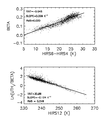
Figure 1.11 Plots of regression parameters for upper tropospheric humidity (UTH) in terms of (top) the lapse rate of HIRS brightness temperature, and (bottom) the absolute brightness temperature from HIRS in the upper troposphere.
Retrieval of temperature and moisture profiles from HIRS/MSU data
Numerous retrieval methods using HIRS/MSU data have been developed in the past 20 years for a variety of applications. It is beyond the scope of this discussion to survey all the strengths and weaknesses of the various techniques. The Improved Initialisation Inversion (3I) method also referred to as Pathfinder Path B, is the consensus retrieval algorithm for climate applications. The advantages of a complete retrieval method are that it makes use of all the available radiance information, is a true solution to the radiative transfer equation, and complete profiles of temperature and moisture are obtained for the troposphere. The disadvantages of a complete retrieval are that it is very time consuming and the inversion process is ill conditioned so that ancillary data are required to stabilise the inversion. Great care must be taken in the choice and use of ancillary information, since this information can create complex and systematic errors in retrievals.
The 3I/Path B inversion algorithm is a direct, non-iterative, physico-statistical method that uses information from all channels of the HIRS/MSU instruments. The algorithm includes many steps: calibration and HIRS/MSU spot collocation, initial air mass classification, cloud detection and correction, first guess selection using the TIGR data set, temperature profile retrieval using Bayesian estimation, cloud parameter determination, cloud clearing of moisture sensitive channels, surface temperature retrieval, and water vapour retrieval using a neural network approach. Data from January 1989 to August of 1994 are currently available and processing is continuing for the entire TOVS period of record, 1979-present. This approach will allow for an estimate of long-term trends of layer-mean specific humidity in the future from HIRS data.
The water vapour retrieval uses a non-linear neural network estimate . The vertical distribution of specific humidity is obtained by using the 4 HIRS channels most sensitive to water vapour absorption (HIRS channels 8, 10, 11, and 12) combined with 6 HIRS channels sensitive to tropospheric temperature (HIRS channels 2-7). The outputs from the neural network are the layer precipitable water for 5 standard layers (100-300, 300-500, 500-700, 700-850, and 850-surface). These outputs are then transformed into water vapour contents above the surface, 850 hPa, 700 hPa, 500 hPa, and 300 hPa. No retrieval is performed for any pressure level if the surface pressure is lower than 850 hPa. Training of the neural network is performed using the TIGR data set. Validation of this technique against in situ observations has been presented in Scott et al. [1999] and is discussed in chapter 2.
1.4.2 Limb Infrared Monitor of the Stratosphere (LIMS)
The Nimbus 7 Limb Infrared Monitor of the Stratosphere (LIMS) experiment yielded near-global distributions of stratospheric water vapour from October 25, 1978 through May 28, 1979 [Gille and Russell, 1984; Remsberg et al., 1984]. LIMS was a cryogenically cooled, broadband filter radiometer with a water vapour channel centred at 6.9 micrometers. A complete profile was obtained every 12 seconds both day and night and with a vertical resolution for retrieved water vapour of about 5 km. Calibrations against an internal blackbody and views to cold Space were performed for each pair of scans. Line parameters for H2O were obtained from the 1980 AFGL tape [Rothman, 1981] and the interfering effects from the O2 continuum were adapted from Timofeyev and Tonkov [1978].
The LIMS data provided the first comprehensive picture of stratospheric H2O. Its distributions have also been used in studies of the stratospheric budget of water vapour by Jones et al. [1986] and Hansen and Robinson [1989], and, in particular, to estimate the H2O mixing ratio as it ascends into the tropical stratospheric "overworld" from below. Those estimated entry-level values ranged from 2.7 ppmv to 3.3 ppmv, respectively.
Quality of the archived (Version 5) LIMS data
The precision of the Level 2 data is estimated to be 10% for pressures greater than 10 hPa, 15% from 5 to 10 hPa, and 20% for pressures less than 5 hPa [Russell et al., 1984]. The accuracy of individual water vapour profiles retrieved from the LIMS radiances is also evaluated in Russell et al. [1984] and Remsberg et al. [1984] by simulating the effects of known sources of LIMS water vapour error and by comparisons with correlative measurements. Uncertainties for daily zonal averages of those profiles are reported in Remsberg and Russell [1987] and are repeated here: 27% at 1 hPa, 17% from 30 hPa to 3 hPa, and 20% at 50 hPa. Profile quality degrades below the 50 hPa level.
Water vapour data quality is affected at the stratopause (1 hPa) because of its poor precision (low signal-to-noise ratio for the LIMS water vapour radiances) and because of significant uncertainties in the radiances from the field-of-view spatial side lobes [Russell et al., 1984]. Kerridge and Remsberg [1989] considered the effects of an additional complication for the retrieval of upper stratospheric LIMS water vapour during daylight. The values at those levels are significantly larger for day versus night - a possible consequence of non-local thermodynamic equilibrium emission at 6.9 micrometers from water vapour and perhaps NO2. As a result, they recommended that scientific studies of LIMS water vapour should be based on the vertical distribution of its nighttime values. Uncertainties in the line parameters for water vapour and from the effects of profile registration and temperature bias tend to limit the quality of LIMS water vapour in the middle stratosphere.
The Version 5 water vapour is less accurate in the lower stratosphere. In particular, there are systematic errors just above the tropical tropopause due to LIMS temperatures that are too warm, to uncertainties in the interfering effects of the pressure-induced O2 continuum, and possibly to contaminating emission from aerosols and clouds that was not accounted for. Furthermore, in the tropics there is a sharp increase of water vapour and temperature just below the tropopause. The instantaneous finite vertical field-of-view width of 3.6 km for the LIMS water vapour channel smoothes across that region, and its effects must be carefully removed in the radiance deconvolution procedure. Uncertainties due to all of these effects cause the position of the retrieved tropical water vapour minimum to occur at an altitude that is 1 to 2 km too high and to be too dry.
Improvements for a Version 6 of the LIMS data
A major effort has been underway to improve the LIMS algorithm and incorporate the latest line parameter data for the retrievals of both temperature and species. One finding that has altered the character of the distributions of all the species is a better estimate of spacecraft attitude along an orbit, based on a match of the calculated and observed LIMS radiances in the lower mesosphere for its narrow-band CO2 channel. This refinement altered both the pressure registrations of the water vapour radiances and its associated temperature profile. The Version 6 Level 2 water vapour distributions have better overall symmetry across both hemispheres, especially for the low altitude increases that are due to tropospheric water vapour and to interfering emissions from clouds. Spectral line parameters are from HITRAN 92 [Rothman et al., 1992] and the O2 continuum model is from Orlando et al. [1991]. Version 6 temperatures are colder at the tropical tropopause. Because of all these changes the isolines of minimum water vapour in the lower stratosphere slope downward toward the Poles in the manner of the isentropic surfaces. Minimum zonal-mean water vapour values are of order 3.5 ppmv in the tropics. Preliminary estimates indicate that the Version 6 single profile random errors are similar to those of Version 5 but the systematic uncertainties are smaller.
There is confidence that the daily zonal mean distributions are improved over those from Version 5. It is expected that the reprocessing of the profile data will be finished and available in 2000. Version 6 is not being considered for this assessment, however.
1.4.3 Stratospheric Aerosol and Gas Experiment (SAGE) II
The Stratospheric Aerosol and Gas Experiment II (SAGE II) is a third generation satellite-borne sensor that utilises the solar occultation technique in the visible to near infrared spectral region to measure the concentration of different species in the atmosphere. SAGE II is flying on the Earth Radiation Budget Experiment (ERBE) spacecraft launched by the Space Shuttle in October of 1984. As of this time, the spacecraft and instrument are functioning normally even though half of the batteries on the spacecraft are dead. Continuous measurements from the SAGE II instrument have been obtained for the last fifteen years. Water vapour measurements are obtained from a spectral channel centred at the 940 nm water vapour band.
Measurement and retrieval technique
SAGE II is a seven channel sun-pointing radiometer consisting of a grating and spectral filters together with photodiode detectors. Mauldin et al. [1985] gives a detailed description of the SAGE II instrument. Because of the solar occultation geometry, SAGE II provides 30 measurement events per day, consisting of fifteen sunrises and fifteen sunsets. With a 57 degree inclination orbit for the ERBE spacecraft, the locations of the SAGE II measurements are generally restricted to latitudes within about 60°S and 60°N. Figure 1.12 illustrates the coverage of the SAGE II measurements from 1985 to 1986. The coverage pattern nearly repeats from year to year.
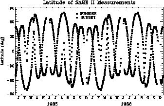
Figure 1.12 Latitude locations for the daily-averaged SAGE II sunrise and sunset measurements during 1985-86.
The SAGE II instrument records the Sun’s radiance when its scan mirror views both above and through the Earth¢ s atmospheric limb. Because the retrieval algorithm considers the profile of the ratio of the atmospheric to the exo-atmospheric radiances, its transmittance as a function of altitude, the SAGE results are essentially self-calibrated. In other words the effects of any degradation of the optical throughput within the instrument is avoided by performing the ratios of those radiance measurements except at altitudes where the signal approaches the noise level. The description of the Version 5.90 inversion algorithm for the SAGE II water vapour is given in Chu et al. [1993] and in Pruvost et al. [1993]. Spectral line parameters were taken from the 1982 compilation of AFGL. Validation and data use for the SAGE II water vapour have been reported [McCormick et al., 1993; Chiou et al., 1993; Rind et al., 1993; Chiou et al., 1997]. The overall SAGE II inversion methodology for the species that affect water vapour (aerosol, ozone, and nitrogen dioxide) can also be found in Chu et al. [1989].
Uncertainty and potential systematic error for the SAGE II water vapour
For the occultation measurements in the 940 nm spectral region, water vapour absorption typically accounts for about 25 % of the total measured extinction, while aerosols, ozone absorption, and Rayleigh scattering account for the other 75 % under normal conditions. However, after a major volcanic eruption the aerosols dominate the extinction at 940 nm. Chu et al. [1993] and Larsen [1998] have performed extensive studies of the sensitivity of the SAGE II water vapour data to its error sources. Systematic errors have been considered from the water vapour line parameters, the emissivity growth approximation computation scheme, temperature bias, and the interference from Rayleigh and aerosol scattering and ozone absorption. It is found that in a low aerosol environment, systematic errors of 20 to 30 percent are typical between the tropopause and 30 km, and the total error is still dominated by the ability to completely remove the aerosol contribution. For altitudes above 30 km and below the tropopause the systematic error is about 10 %, primarily due to line parameter uncertainties. Random errors arise from uncertainties in the measured signal, altitude registration, and the effects of ozone, temperature, and aerosol. The combined random error for single profiles is between 10 and 20 % up to 40 km. Table 1.26 summarises the error analysis for the SAGE II water vapour profiles.
Table 1.26 Summary of SAGE II Water Vapour Data Errors
| Error source |
|
|
|
|
forward model (line parameters, emissivity growth approximation tables) |
0-25 5-40 |
10 6 |
|
|
aerosol correction (1990 level at midlatitude) |
|
|
|
| ozone correction |
|
|
|
| Rayleigh correction |
|
|
|
| measurement error |
|
|
|
| altitude error |
|
|
Potential short-term and long-term errors
As discussed above, the water vapour retrieval accuracy is extremely sensitive to the correct removal of aerosol interference. Even with relatively low aerosol levels, such as the condition in 1990 at mid-latitudes, the estimate of potential systematic error in the water vapour profile due to aerosol is about 25%. Sensitivity analyses by Chu et al. [1993] for the higher levels of aerosol in 1985 show that the systematic error in water could be as high as 100% at mid-latitudes and much higher at tropical latitudes.
Besides the time dependent errors due to aerosol interference, there are still two other potential time dependent errors caused by changes in the SAGE II instrument. The first problem is the scan mirror reflectivity with scan angle, which was very stable from 1984 through 1990. However, after 1990 the functional behaviour of the reflectivity with angle started to change. A correction has been attained, but it must be implemented a year to two years after data acquisition because of the large number of calibration data that are required for its characterisation. This process has been complicated with the recent failure of the spacecraft batteries. As a result, there is a potential for systematic error in the water vapour retrieval, especially for values at higher altitudes. The second potential problem is a drift in the 453 nm filter. While such a drift primarily affects retrieved NO2, it can also produce a drift in the retrieved aerosols for the 450 nm region. Any drift in the 450 nm aerosol, even at low aerosol amounts, can potentially affect the water vapour retrieval because of its high sensitivity to aerosol interference.
After considering all the short term and long term errors it is questionable whether the SAGE II data can be used to assess changes in water vapour after 1990 with an accuracy of less than 50%. Prior to that time, trends are uncertain from the top of the volcanic aerosol layer to near tropopause altitudes. A better estimate of the quality of SAGE II water vapour should be possible from the Version 6 algorithm, which will incorporate better corrections for the drifts in scan mirror reflectivity and in the 453 nm filter.
Currently available SAGE II water vapour data
SAGE II water vapour data from January 1986 to May 30, 1991 are available at the NASA Langley Distributed Active Archive Center (DAAC). This 5-year data set was obtained with the Version 5.90 algorithm. The El Chichon aerosols severely affected the water vapour data through 1985. Similarly, the Pinatubo aerosols affected the water vapour data after May 1991; aerosol extinction levels did not become equivalent to those of 1986 until 1996.
1.4.4 Atmospheric Trace Molecule Spectroscopy (ATMOS)
General description
The Atmospheric Trace Molecule Spectroscopy instrument (ATMOS) is a Space Shuttle-borne Fourier transform infrared spectrometer that simultaneously measures vertical profiles of a variety of atmospheric species from the upper troposphere to well above the stratosphere [Farmer et al., 1987; Gunson et al., 1990 and 1996]. ATMOS is a fast-response Michelson interferometer, which obtains high resolution (~0.01 cm-1), broadband spectra through orbital sunrises and sunsets during solar occultation by the Earth. This observational technique provides immediate calibration data with each occultation, making the instrument self-calibrating and thereby eliminating long-term drift. The accuracy of such measurements is generally insensitive to changes in background transmission, e.g., resulting from heavy volcanic aerosol loading, although precision will be degraded with a significant reduction in the signal.
ATMOS is currently packaged to fly on the Space Shuttle. From a low-Earth orbit of ~300 km altitude typical for the Space Shuttle, an occultation observation requires ~4 min. With an instrument scan time of 2.2 s, approximately 100 spectra are recorded, resulting in a vertical spacing of ~2 km in the lower stratosphere to ~4 km in the upper stratosphere. At tangent heights in the middle stratosphere, the vertical spacing is 2-3 km. The vertical spacing coupled with the instantaneous instrument field-of-view of 1.0-2.8 mrad leads to an effective vertical resolution of 3-6 km [Gunson et al., 1996].
ATMOS has been deployed four times as part of the Spacelab 3 and ATLAS-1, ATLAS-2, and ATLAS-3 missions [Kaye and Miller, 1996]. Observations from these missions cover the following periods of time and ranges of latitude:
Table 1.27 Listing of ATMOS missions
| Mission | Period | Latitudes | Measurement mode |
| Spacelab 3 | 30 Apr - 1 May 1985 |
47 - 51S 26 - 35N |
sunrise sunset |
| ATLAS-1 | 25 Mar - 2 Apr 1992 |
0 - 55S 0 - 31N |
sunrise/sunset sunrise |
| ATLAS-2 | 8 - 16 Apr 1993 |
10 - 50S 63 - 68N |
sunset sunrise |
| ATLAS-3 | 3 - 12 Nov 1994 |
65 - 72S 3 - 49N |
sunrise sunset |
In order to enhance the signal-to-noise ratio and minimise zero-level offsets, measurements are made in selected spectral regions defined by optical bandpass filters given in the following Table.
Table 1.28 Spectral regions of ATMOS
|
|
|
|
|
|
|
|
|
|
|
|
|
|
|
|
|
|
For each sunrise or sunset occultation, spectra are recorded in one of these six transmission regions; the filter selection determines which species can be retrieved for that occultation [Gunson et al., 1996; Abrams et al., 1996a]. The accuracy of the ATMOS measurements is generally dominated by experimental uncertainty in the line strengths and the isolation of spectral features (e.g., the degree of blending or overlap with spectral features of other species), particularly at the lower tangent heights. The precision is a statistical measure of the scatter in the retrievals and is largely determined by random spectral noise and by uncertainties in the tangent altitudes and the assumed temperature-pressure profiles.
Retrieval description
After the interferograms have been transformed to spectra, the spectra are referenced to an average exo-atmospheric spectrum (from measurements above 165 km), eliminating solar and instrumental spectral features [Norton and Rinsland, 1991]. An initial "first-guess" tangent height is assigned based on the spacecraft ephemeris data. The tangent pressure is retrieved by fitting temperature-insensitive CO2 absorption bands [Abrams et al., 1996b], and refined temperature-pressure profiles are retrieved from absorption features that provide the populations of CO2 rotational states [Stiller et al., 1995]. These retrievals provide pressures with an estimated accuracy of 4-10% and precision of 1-3% and temperatures with an accuracy of 2-3 K.
Smaller spectral intervals (micro-windows) containing predominantly the absorption features of a selected trace gas are used for the retrieval of the volume mixing ratio profiles. These micro-windows differ with species and altitude and depend on the location, shape, and strength of the target gas absorption, spectral congestion, and temperature dependence of the spectral features [Gunson et al., 1990, Brown et al., 1996]. Line strengths used to retrieve water vapour are given by Brown et al. [1996].
The Version 3 algorithm was adapted from an algorithm developed for the analysis of MkIV balloon spectra (see Section 1.3.3) and differs from that of Version 2 in several ways. In particular, the Version 3 algorithm employs a simultaneous global fit for multiple species and tangent pressures rather than the sequential onion-peeling approach for individual species used for Version 2. This new version of the ATMOS data extends to lower altitudes and includes additional species. Version 3 retrievals provide [H2O] for all filters ([X] denotes volume mixing ratio of species X). Both versions of water vapour are retrieved in the altitude range of ~10-80 km for Filters 2, 3, and 9 with an average estimated (1s) accuracy of 6% [Abrams et al., 1996a, Gunson et al., 1996]. Water vapour is retrieved for Filter 4 with a much larger uncertainty and a significant systematic bias for both versions. In addition, Version 3 water vapour retrievals are available for Filter 12, and comparisons among [H2O] profiles from Filters 3, 9, and 12 show excellent agreement [Michelsen et al., 2000a]. Version 3 retrievals of water vapour are available for Filter 1, but these retrievals currently appear to be unreliable, perhaps because of the lack of temperature-insensitive H2O lines in Filter 1. A preliminary estimate of the random error for Version 3 yields an average value of 11% in the stratosphere with uncertainties as high as 30% in the troposphere.
1.4.5 Halogen Occultation Experiment (HALOE)
The HALOE experiment uses solar occultation measurements to infer high resolution mixing ratio profiles of H2O at 6.61 micrometers and over an altitude range of 10-85 km. HALOE also provides for the effects of aerosol extinction at four infrared wavelengths, plus absorption profiles of other gases including CH4 and CO2. The nearly conserved chemical quantity, 2*CH4 + H2O, has also been obtained with the HALOE profiles. The instrument measures the atmospheric transmission of sunlight as the sun rises and sets relative to the spacecraft. A description of the experiment and its retrieved quantities is found in Russell et al. [1993]. Here its measurements, retrieval algorithm, and error sources are briefly described, focusing on issues relating to the accuracy of stratospheric water vapour.
Measurement and retrieval description
The angular resolution of the HALOE instantaneous field-of-view is 2 arcmin in elevation by 6 arcmin in azimuth. Projected to the limb tangent point, this is about 1.6´ 4.8 km, respectively. The combined effect of optical resolution and electronic signal smoothing yields an effective vertical resolution of about 2.3 km. Figure 1.13 depicts the projection of the instantaneous field-of-view onto the solar disk image. As the Sun sets, its refracted image shrinks in apparent elevation and the instantaneous field-of-view, which is positioned at a fixed angle from the top edge, covers more area of the Sun and moves closer to the centre of the limb darkening curve. This changing effective source function is explicitly modelled using exoatmospheric solar scans and detailed limb path refraction calculations.
The UARS orbit (57° inclination, 600 km altitude circular) provides HALOE with 15 sunrises and 15 sunsets each day and near-global coverage over the 36-day yaw cycle. Figure 1.14 shows the global sunrise and sunset locations for 1995. HALOE samples at 8 Hz, equating to a tangent altitude grid of 0.18 to 0.4 km depending on Sun sink rate (a function of orbital beta angle). This over-samples the effective 2.3 km resolution by a factor of 5 or greater. The measurements are interpolated onto a 0.3 km grid for processing by the retrieval algorithm.
HALOE uses two distinct measurement techniques: broadband radiometry and gas correlation radiometry. In broadband radiometry the transmission in a channel is estimated by t(t) = V(t) / Vexo, where V(t) is the detector voltage signal in time and Vexo is the exoatmospheric value. The retrieval algorithm compares t to a modelled transmission to determine the target-gas mixing ratio. Note that this ratio measurement does not require absolute radiance calibration, a feature that greatly benefits the ability to infer long-term trends. Broadband radiometry measurements are used to retrieve H2O and temperature/pressure (using CO2 absorption measurements).
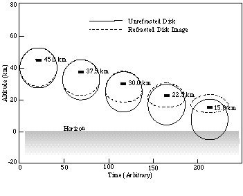
Figure 1.13 HALOE instantaneous field-of-view location on the solar disk during a sunset occultation event. Note that the instantaneous field-of-view is locked (fixed) relative to the top apparent edge of the Sun. Event duration (from 150 km to bottom of profile) ranges from about 40 to 110 sec, depending on beta angle.
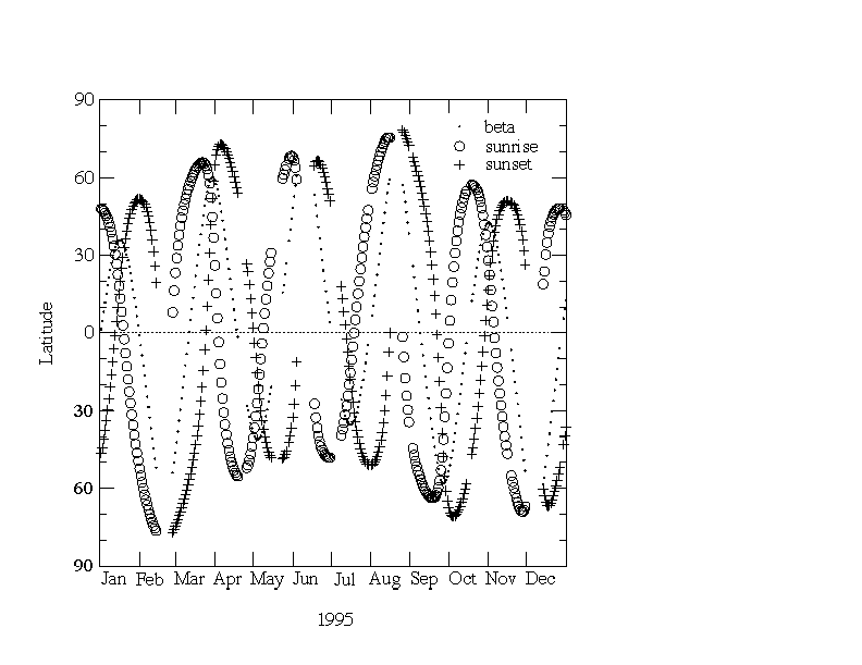
Figure 1.14 HALOE global sampling pattern for 1995. There are 15 sunrise and 15 sunset occultations each day. Plotted are the daily mean sunrise and sunset locations and beta angles. Successive individual sunrise (or set) events are separated by 24° in longitude and within ± 0.6° in latitude.
In gas correlation radiometry the incoming beam is split between two paths: one through a cell filled with the target gas and one through a vacuum path. Voltage signals resulting from these, VG(t) and V(t), respectively, are electronically balanced exoatmospherically. The retrieval models the modulation signal, M = [VG(t) - V(t)] / V(t), to infer CH4. The value of M is nearly independent of absorption from aerosol. Gas correlation radiometry is used to retrieve gaseous species in four separate infrared channels, and aerosol extinctions are then retrieved from the V(t) signal as in broadband radiometry.
The first task in the processing is the pressure registration of the transmission profiles. In the 30-40 km region, the algorithm matches a band averaged CO2 channel transmission with a modelled transmission derived from National Center for Environmental Prediction (NCEP) temperature and pressure data. Next, temperature/pressure is retrieved from 35 to 85 km, and the pressure registration is repeated using these data. H2O, T/P, and aerosol extinction are then obtained by broadband radiometry and CH4 by gas-cell correlation radiometry using a modified onion-peel algorithm.
Retrievals are done sequentially in an iterative fashion for computational simplicity and stability. Studies determined there is no significant compromise in accuracy from this approach. Altitudes above ~80 km are treated as one extended layer in the water retrieval. This boundary condition has less than a 5% effect at 75 km and negligible effect below 70 km. Although each transmission profile is sampled at 0.3 km spacing, it is separated into 7 profiles having 2.1 km spacing. Each of these 7 is used to retrieve the target gas, and the results are re-interlaced into a final 0.3 km spaced profile and then smoothed. Aerosol extinction retrieved from the 5.26 mm channel is extrapolated to the radiometer channels with a sulphate aerosol model [Hervig et al., 1995].
Error sources and their impact on trends
The 3rd public release of the HALOE water vapour profiles (from the Version 19 algorithm) is used in this report. They are accompanied by a quality profile of mixing ratio uncertainties due to random instrument and tracker noise plus aerosol effects. Systematic error effects have been tabulated in Harries et al. [1996] and Hervig et al. [1996] for an earlier version of the HALOE algorithm, but those estimates are nearly the same as those for Version 19. There are systematic errors from the forward model and the altitude registration of profiles. There are also uncertainties in the line parameters for H2O and in the knowledge of the interfering effects from CH4 and from aerosols. Line parameters for the Version 19 retrievals were taken from the HITRAN 1992 compilation. In the lower stratosphere there are biases in the corrections based on the O2 continuum model of Orlando et al. [1991], and the minor effects of H2O continuum absorption are not accounted for. The combined, single-profile HALOE errors are discussed in Harries et al. [1996] and summarised later in Table 1.30.
Error sources dominating trend determination are different than those for individual profiles. Random errors become insignificant when huge amounts of data are used to infer trends. Systematic errors such as calibration errors, if stable, also have small effects on trends. The complicated observation pattern can alias seasonal and latitudinal changes, confusing trend determinations. In the following paragraphs the main sources of error affecting water vapour and their potential impact on trends are summarised.
Pointing/Tracking
Pointing uncertainty is often the dominant source of measurement error in the lower stratosphere and below. Pointing geometry can be determined from spacecraft location and solar ephemeris data, if the Sun is accurately tracked. HALOE tracks the top edge of the Sun and relies on ephemeris data and an atmospheric refraction model to compute tangent point locations. The tracking system centres the instantaneous field-of-view on the Sun image in azimuth and locks it a fixed angle below the top edge with a 16.2 arcsec precision and a knowledge of half that value. The pointing is known to about 100 m at the limb. The system has proven extremely reliable throughout the stratosphere and mesosphere, inducing random retrieval mixing ratio errors of less than 3% in clear air. Pointing errors become most pronounced below the 100 hPa level, where water vapour mixing ratio errors from tracking biases can exceed 10%. In heavy aerosol or cirrus clouds, the tracker cannot always accurately distinguish the top edge of the Sun and the retrievals terminate when the track is lost.
The tracking system has shown stable performance. Since the solar source function is non-uniform, it is essential that the tracking system provide exact instantaneous field-of-view location on the solar image. Periodically, HALOE performs diagnostic solar scans to calibrate the tracking system. Although there has been a response decrease of about 22% (through 1997, six years from launch) for the vertical tracking diodes, there has been no observable change in vertical tracking performance, precision, or knowledge. This is because the tracking logic uses only relative responses of diodes to detect the solar edge. This stability is expected to continue until response is down by 90% or more (after year 2015).
A possible concern is the azimuth tracking stability. As the azimuth-sensor optics degrade with time (13% through 1997), a slight change in stability could change results at low altitudes. Fortunately, the solar intensity is relatively flat at 6.61 mm (H2O) and the 2.80 mm (CO2) channel is used only above 35 km (NCEP temperatures are used below 35 km). Thus, HALOE water vapour trends should not be susceptible to small changes in azimuth tracking performance.
Source Function
High-resolution exoatmospheric scans are measured for each event and provide well-calibrated source functions. Sunspots are detected in the source functions on rare (<5%) occasions, mostly during solar maximum. When a sunspot is near the instantaneous field-of-view, errors can be induced in the source function due to tracking jitter, relative image rotation of the solar disk image, and refraction. The effects are minor in the 6.61 mm H2O channel source compared to shorter wavelengths and again the 2.80-mm (CO2) channel is used only above 35 km. The few events that do contain significant error due to sunspots are noted in the quality comments in the data files.
Relative Spectral Response
Spectral response functions of all the HALOE radiometers are believed to be extremely stable. Witness filters have been found stable for over 15 years. Trends in peak voltages during exoatmospheric scans show that through 1997 (over six years) the peak output of the H2O channel changed only 0.5%, and only 2.5% in the CO2 channel. Spectral changes of this order would have a negligible effect on results because the mean atmospheric spectral characteristics for these channels would not change appreciably. There are also indications that these changes are non-spectral, imparting no effects on trends. Finally, analysis of signals from an internal 1000 K blackbody also indicates spectral stability of the radiometer channels.
The only other possible source of spectral change is from the contents of the gas cells. This indirect effect arises from using the nitric oxide (NO) gas correlation channel to infer aerosol extinction in the radiometer channels. That procedure is nearly insensitive to gas cell content. Also, the cell content for all correlation channels has proven stable over the mission according to an in-depth analysis of retrievals at various orbital beta angles. The overall conclusion is that HALOE has been spectrally stable throughout the mission. Changes in the relative spectral response of the H2O and CO2 signals, if they exist, must be well below the 1% level.
Noise
The instrument noise equivalent absorption for the H2O channel is insignificant below 10 hPa, and less than 4% at 1 hPa. Noise is a primary error source only above the middle mesosphere.
Forward Model
The forward models used in the HALOE processing utilise the BANDPAK [Marshall et al., 1994] and LINEPAK [Gordley et al., 1994] codes. The broadband calculations use either the Curtis-Godson or pseudo-mass approximation, along with a spectral overlap correction for secondary species [Marshall et al., 1994]. The choice of approximation method was determined by accuracy analyses using line-by-line methods. The gas correlation measurements are simulated by rigorous line-by-line calculations. The forward model for H2O is accurate to within 1% in the stratosphere. The broadband transmissions of fundamental vibration bands have only slight temperature dependence, making the temperature uncertainty a small contribution to the total H2O retrieval error. The forward model for the T/P (CO2) channel is accurate to within 1% at altitudes where it is used-above 35 km. Below that, NCEP data are used. Since the forward model does not vary, it should have no effect on trends, except in conditions of significant and changing aerosol interference.
Aerosol and Cloud Extinction
During the period of large volcanic aerosol loading after the eruption of Pinatubo, the water channel transmission at tangent altitudes below 25 km was strongly affected by aerosol extinction. It was determined through correlative comparisons that the HALOE algorithm removes the effects of aerosol with a residual uncertainty equivalent to 7% of the aerosol extinction [Steele and Turco, 1997]. Aerosol error profiles are included in the HALOE quality data. A changing aerosol or cloud-related error would induce changes in inferred trends. Therefore, researchers should consider those changing aerosol-related error profiles when estimating upper limits of those effects on trends. Because this module of the HALOE algorithm assumes that the extinction is due to sulphate aerosol, corrections to the data in cloudy conditions are suspect. However, a new cloud identification process has been developed [Hervig and McHugh, 1999]. That procedure is described on the HALOE web site and can be used to screen out cloud contaminated data.
Contaminant absorption
Contaminant absorption from other species in the H2O channel is small because of the relatively high absorption by water vapour in its spectral band. The two primary interferents are O2 (continuum) and CH4. The O2 absorption is calculated with an assumed constant mixing ratio at all altitudes and with a band strength uncertainty of less than 5%, leading to systematic errors in water vapour of up to 10% below 100 hPa but less than 4% above 10 hPa. Methane absorption has a smaller effect, and causes errors of less than 4% at all altitudes. However, none of these effects should be a source of trend error.
Time Response
The time response of the measurement system can change the effective resolution due to the Sun sink rate. Time response changes can be observed by analysing scans on and off of the Sun. No change in response time constant has been observed. A 1% change in resolution can cause up to a 0.05% change in retrieved water vapour. The resolution is believed to have changed less than 2%.
Optical Degradation
Signal characteristics when scanning on and off the Sun can also be used to infer off-axis scatter and resolution changes. No detectable change has been observed. In addition, the gas correlation difference signals give an extremely sensitive response to field-of-view differences (~1 ppmv) between effective vacuum path and gas cell path signals. There has been no significant change in these signals. Although these findings do not directly relate to the water channel, they provide further confidence that the instrument has been optically stable.
Orbital Geometry and Sampling
Because the UARS orbit precesses with a period of about 70 days, the occultations occur at various beta angles (angles relative to the orbital plane) and induce changes in Sun sink rate. The eccentricity of the orbit and the Earth’s oblateness also combine to cause a time-dependent change in the zenith angle vs. height relationship at large beta angles. These effects are important–they can cause up to 25% error in mixing ratio if not included–and are most pronounced at specific latitudes (such as the mid and high latitudes in the southern hemisphere) and seasons. The natural variation in pressure-altitude also contributes more error at large beta angles. The beta angle shifts phase by five days per year; one 70-day orbital precession cycle will take 14 years. Although great care has been taken to explicitly incorporate all of these effects in the data analysis, the results for very high beta angle (>55° ) can often differ by up to 3%. The effect on trends is expected to be negligible.
On the other hand, trends obtained with small subsets of data at specific latitude bands can give degraded results because the five-day shift each year has the potential of aliasing the results with season and latitude (see Figure 1.14). Correlative comparisons at a particular site also have the potential to incur a systematic change in space and time coincidence, leading to false trends from a series of comparisons. Of course, there were periods when HALOE was not taking data, and one should recognise that prolonged gaps in the observations can affect a determination of trends. However, that possibility is not evaluated in this chapter because it would not arise from an instrument or algorithm error. In summary, changes in the sampling for occultation measurements can lead to trend biases in H2O.
Algorithm
The processing algorithm can be a source of faulty trends if time dependent errors occur. For example, the HALOE algorithm assumes a 1.5 ppmv (0.45%) yearly growth in CO2 mixing ratio. An error in this increase can lead to a nearly equal percentage error in inferred water mixing ratios. Another time dependent error that may be quite significant comes from the aerosol correction. In fact, if the data from the first year of the mission were used, the Pinatubo aerosol would likely be the largest contributor to trend error in the lower stratosphere. However, by filtering out data through 1992 the errors related to corrections for aerosol extinction are insignificant. HALOE temperatures are retrieved upward from 35 km and therefore are not susceptible to errors from auxiliary data in that region. Below 35 km, the NCEP temperatures are used. The HALOE registration with density at all altitudes is insensitive to NCEP errors. The algorithm does not use any a priori information other than the upper boundary profile shape, as discussed above. However, retrieval constraints limit the ability of the algorithm to accurately follow extremely sharp vertical gradients, in particular the large changes in water vapour in the troposphere. Such constraints contribute up to a 40% low bias to HALOE water vapour below the hygropause, an error that will be more severe at particular latitudes and seasons but otherwise independent of time. Consequently, a systematic elevation or lowering of the tropopause could induce false trends at altitudes just above the tropopause. Researchers should take great care in inferring trends near the tropopause.
Summary comments and algorithm improvements
Generally, HALOE water vapour in the stratosphere is believed to be accurate and stable. Some small sunrise/sunset discrepancy remains at the very highest beta angles (>60°) but those instances occur for only a small fraction of the data. Researchers using Version 19 data for extracting trends in the lower stratosphere and troposphere should screen for cloud contamination and heavy aerosol conditions, as mentioned above. For comparisons with other measurements one should pay attention to the random errors that are provided in the archive for each Level 2 profile. Combined systematic errors are given in Table 1.30 at the end of this chapter.
Improvements are being made to the algorithm that will affect distributions of HALOE water vapour in the lower stratosphere. For example, a better model for the temperature-dependent effects of the interfering O2 continuum is now available. The effect of that change is considered along with the HALOE Version 19 comparisons with correlative measurements of Chapter 2. Constraints in the interleave procedure for combining individual profiles into a final retrieved profile can be relaxed for the lower stratosphere. This modification yields a more accurate transition when going from the dry values of the hygropause to the much higher mixing ratios of the upper troposphere. Both of these improvements are envisioned for a Version 20 and will lead to larger values of water vapour (and 2*CH4 + H2O) below about the 50 hPa level. However, neither of these improvements should have a significant impact on a determination of H2O trends after 1992. Sampling bias is the only remaining concern for a determination of trends.
1.4.6 Microwave Limb Sounder (MLS) - lower stratosphere
Measurement description
The UARS Microwave Limb Sounder (MLS) measurements are observations of millimetre-wavelength thermal emission at 183 GHz as the instrument field-of-view is vertically scanned through the atmospheric limb [Barath et al., 1993; Waters, 1993]. The antenna is scanned mechanically across the limb and completes one full scan every 65 seconds. The signal entering the radiometer contains radiances emitted by the limb of the Earth averaged over the antenna field-of-view and a small extraneous radiance or baseline comprised mostly of radiation scattered and thermally emitted by the antenna. The baseline is spectrally flat but weakly dependent on scan-angle. Calibration is accomplished by interspersing several space views (at 2.7 K) and calibration target views (at about 300 K) with the 26 limb views during each limb scan. The switching is done using a mirror located between the antenna and the radiometers; this means that the baseline cannot be accounted for by the calibration process [Jarnot et al., 1996].
MLS uses double-sideband heterodyne radiometers. Signals from two sidebands, equally spaced about the local oscillator frequency, are combined (with slightly unequal weights) into a single measurement. The weights, or sideband ratios, are measured for the six broadest channels in each band as part of pre-launch instrument calibration. There are 15 channels across each of the six 510 MHz wide filter banks. Channel widths vary from 2 MHz at the line centre to 128 MHz at the band edges. Signal-to-noise is roughly proportional to the square root of the channel width. The fifteen channels dedicated to the 183.3 GHz H2O line (wavelength 1.64 mm) are referred to as "Band 5".
This write-up describes two versions of the MLS water vapour data. Version 4 was the latest public release of the MLS data at the time of this study. The MLS validation papers refer to Version 3 data; in this report is described briefly how the data changed between Version 3 and Version 4. Prototype Version 0104 was generated during the development of Version 5. This prototype has been shown to be an improvement on Version 4 in a number of ways [Pumphrey, 1999], and it is used for the inter-instrument comparisons in Chapter 2.
The horizontal resolution is approximately 400 km, limited by radiative transfer in the view direction and by the motion of the satellite. The vertical resolution is limited to about 3 km by the antenna field-of-view. The MLS data (for Version 4 and earlier) are produced on a vertical grid with points spaced each factor of 101/3 change in atmospheric pressure, giving a vertical grid of ~5.4 km. The prototype version 0104 data set is produced with points spaced each factor of 101/6, giving a vertical grid of ~2.7 km. The resolution actually achieved is close to this value in the mid and upper stratosphere, but broaden in the mesosphere and the extreme lower stratosphere.
The limb scan used in normal operations consists of discrete steps between about 90 and 0 km tangent heights with the step spacing for the scan varying between 1 km in the lower stratosphere to 5 km in the mesosphere; individual spectra are measured during 1.8 s dwells between steps. The poor vertical resolution achieved in the mesosphere is a result of the large scan step used in this region.
MLS performs routine measurements continuously every day. The latitudinal coverage is from 34° on one side of the equator to 80° on the other. UARS performs a yaw manoeuvre at 36-day intervals, and at these times MLS high-latitude coverage switches between north and south. The typical profile spacing is 3 to 4° in latitude, with significantly denser coverage in small bands close to the turn-around points (near 34° or 80° latitude). The spacing between orbits in longitude is typically about 25 degrees, but since there is overlap arising from ascending and descending orbits the average daily sampling in longitude is about 12°. The stratospheric water vapour product is available between 19 September 1991 and 15 April 1993 at which time the 183 GHz Radiometer failed. The data coverage is shown in Figure 1.15.
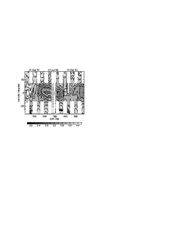
Figure 1.15 The coverage of MLS H2O data. The gaps poleward of 34° are a result of the UARS yaw cycle. The gaps in June 1992 are due to problems with the solar panels on the UARS spacecraft. The quantity contoured is mixing ratio at 68 hPa.
Algorithm descriptions
In this subsection the standard Version 4 and the prototype Version 0104 data sets are described. In both cases the retrieval is done using a Maximum Likelihood (Optimal Estimation) formula [Rodgers, 1976]. This approach gives an estimated profile which is a correctly weighted mean of an a priori estimate of the profile and a weighted least squares fit to the radiances. A forward model F is required - this calculates the radiances y = F(x) that the instrument would measure if the atmosphere were in a given state x. The forward model also calculates the influence function matrix K = dy / dx. The optimal estimation formula gives an estimate of the error of the solution based on the errors in the radiances and in the a priori profile.
The Version 4 Algorithm
The main forward model is a line-by-line radiative transfer calculation. Line parameters are taken from the Jet Propulsion Laboratory catalogue [Pickett et al., 1992]. A continuum due to water vapour and dry air is included. Effects of refraction are included but line-of-sight gradients are not. This forward model is used to calculate radiance yL and influence functions K for a linearisation profile xL.
The Version 4 retrieval calculation uses a linear approximation to the forward model: the radiances y are calculated using the formula y=F(xL)+K(x-xL). If this approximation is valid, the optimal estimation formula gives a solution when applied once - no iteration is needed. The optimal estimation formula is used in its sequential form. The retrieval is carried out in stages: the temperature and pointing are retrieved in the first stage and the mixing ratios in subsequent stages. The extraneous baseline radiance is handled by retrieving it along with the mixing ratio profile. The calculated radiances F(xL) and their derivatives, K, are obtained by look-up table from climatological conditions and then interpolated in the vertical to the tangent pressure.
To ensure that the errors returned by the optimal estimation formula are a reasonable estimate of the accuracy, the errors assumed for the radiances include not only the measurement noise but also terms to account for errors in the retrieved temperature, retrieved tangent pressure and interfering species. These terms are included in an ad-hoc way. A limitation of the sequential formula is that it assumes that the measurement error covariance matrix is diagonal, preventing these terms from being included in the theoretically correct manner. A further term is added to account for the lack of accuracy of the linear approximation to the forward model. Nonlinearity errors are worst for measurements with large optical depths. An ''opacity criterion'' is used to reject such measurements. Radiances with tangent pressure greater than 100 hPa are also not used.
The a priori values used for water vapour are based on the climatology from Pumphrey et al. [1998]. The a priori uncertainty is set to 2 ppmv throughout the middle atmosphere. Averaging kernels [Rodgers, 1990] for MLS water vapour are well-peaked functions with some degradation in measurement sensitivity occurring in the lower mesosphere and at 46 and 22 hPa. Examples for Version 3 are presented in Lahoz et al [1996]; functions for Version 4 are similar. Most of the smoothing arising from the MLS measurements is caused by the use of the fairly coarse Level 2 retrieval grid.
Prototype Version 0104 Algorithm
This version of the data was produced using an independently developed forward model. Given identical input data, the model produces output that agrees very well with the JPL Forward Model. For the purposes of producing Version 0104 the forward model is run with two parameters per channel adjusted to values chosen in order to improve the 'closure' of the retrieval. These parameters are (1) the sideband ratio of the channel and (2) the frequency offset of the channel from the line centre. Further details are in Pumphrey [1999] and Pumphrey and Buehler [2000].
The prototype retrieval is for water vapour only; Version 4 temperatures and pressures are used and are assumed to lie within the errors in the Version 4 files. The OE formula is used in its matrix multiplication form. The covariance matrix for the error in y is not assumed to be diagonal, so the errors in temperature and pressure can be included correctly. An extra term is added to account for modelling errors. The Inverse Hessian or Newtonian iteration algorithm is used, as the problem is mildly non-linear. A linearised forward model is not used; the full radiative transfer calculation is done as part of the retrieval process. As with Version 4, an opacity criterion is employed to ensure that those radiances, which depend in a very non-linear way on mixing ratio, are not used. The criterion is less strict for Version 0104, so that more of the radiance measurements are used than is the case for Version 4.
The state vector has an element for every UARS pressure surface in the stratosphere, giving a grid resolution that is twice as fine as the Version 4 grid. The resolution achieved is almost as good as the grid resolution. The averaging kernels in Figure 1.16 suggest that the data are usable through 68 hPa. At mid-latitudes the data are useful even at 100 hPa.
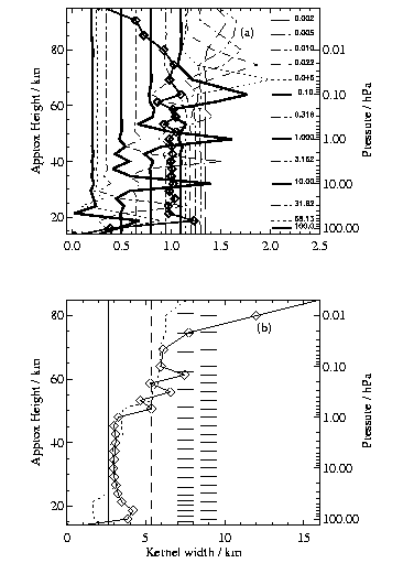
Figure 1.16 The upper panel, (a), shows the averaging kernels for some of the pressure levels on which water vapour is retrieved. The kernels are displaced to the right by an amount proportional to the altitude to which they refer in order to make the figure clearer. Kernels are not shown for all retrieval levels in order to reduce clutter. The line with diamonds is the sum of all the averaging kernels at each altitude. The lower panel, (b), shows the width of the averaging kernels as a function of altitude. The width is presented in the same `approximate height' units as the altitude. The two sets of horizontal lines indicate the tangent altitudes for this scan (left) and the retrieval grid (right). The faint dotted line is the distance between the closest two scan altitudes. All data are for an equatorial scan.
The a priori error is 3 ppmv throughout the stratosphere. The a priori covariance matrix S has off-diagonal elements given by Sij = (Sii Sjj)exp( -(zi - zj)2 / hz2), where zi and zj are the pressure heights of the ith and jth surface and hz is a smoothing length (which is approximately 3 km in the stratosphere).
The baseline signal was determined for an array of 26 numbers, one for each scan position. Above 3 hPa the baseline can be estimated accurately because there is no signal from the atmosphere in the wing channels. It becomes difficult to separate baseline from atmospheric signal at lower altitudes, so the baseline is assumed the same as its 3 hPa value. However, its error becomes larger for those lower altitudes.
Estimates of error
Version 4
A few changes were made over the Version 3 H2O data described by Lahoz et al. [1996]. A post-launch estimate of the pointing offset between the 63 and 183 GHz radiometers is now used, as obtained from MLS antenna scans across the moon [Jarnot et al., 1996]. The pointing offset change from Version 3 corresponds to a tangent height change of about +180 m. Sideband ratios estimated from the in-flight radiances were used instead of ones based on pre-launch calibrations. The manner in which temperature and pressure errors were accounted for was updated also. The Version 4 profiles are drier in the upper stratosphere, the retrieved error bars are smaller in the middle stratosphere, and the a priori contribution is much reduced in the polar winter lower stratosphere.
The error sources that affect MLS water vapour are: (1) radiance noise; (2) radiance scaling error (includes radiometric, sideband ratio, and line strength errors); (3) error in filter shapes; (4) error in FOV direction (relative to the 63 GHz radiometer FOV used for tangent-point pressure retrievals); (5) error in FOV shape (includes spectral dependence); (6) error in H2O line width; (7) errors from retrieval numerics; (8) error contribution from a priori; (9) error in tangent pressure; (10) error in atmospheric temperature; (11) error in dry air continuum; and (12) error in knowledge of O3.
The radiance noise, temperature, and tangent pressure are sources of random error. All except radiance noise may be causes of systematic errors, too. The main sources of systematic error (especially in the lower stratosphere) are errors in tangent pressure, temperature, and the modelled dry air continuum. Precision and accuracy values are plotted and tabulated in Lahoz et al. [1996]. Estimates of the pressure-dependent (total) accuracy and single-profile precision are plotted in Figure 1.17. The precision estimate is just the standard deviation of the water vapour over a period of three days at the equator, where there is little variability. This must be regarded as an upper bound on the precision. Accuracy estimates include the square roots of the diagonal elements of the covariance matrix returned by the retrieval plus the effects of errors in the forward model.
Prototype Version 0104
Version 0104 water vapour is drier than Version 4 in the middle and upper stratosphere, but they agree well in the lower stratosphere. Version 0104 precision and accuracy in Figure 1.17 were obtained in the same way as for Version 4.
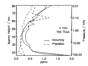
Figure 1.17 Estimates of accuracy (solid line) and precision (dashed line). The thin lines are for Version 4 and the thick ones are for Prototype Version 0104.
Version 5 and further improvements
MLS Version 5 has been archived recently, and it provides much improved temperature and pointing retrievals using the same vertical grid as prototype V0104. The OE formula is used in its matrix form, allowing errors in quantities retrieved from the other bands to be included correctly. The baseline radiance is included by retrieving it as in Version 4. While the Version 5 water vapour retrieval includes many of the improvements found in Version 0104, the initial results suggest that it has more problems between 46 and 100 hPa than V0104.
There is still a gap at 100 hPa in the MLS measurements of water vapour between the stratospheric data set described here and the upper tropospheric data set described in Section 1.4.7. It is hoped that it will be possible to extend the stratospheric retrieval to give better data at 100 hPa and perhaps extending to the 147 hPa level. It may eventually be possible to combine the data from the 183 and 205 GHz bands in a single retrieval.
1.4.7 Microwave Limb Sounder (MLS) - Upper Troposphere
The Microwave Limb Sounder (MLS) experiment [Waters et al., 1999] on the NASA Upper Atmosphere Research Satellite (UARS) has provided a new data set for upper tropospheric humidity (UTH). Although not designed for this measurement, the UARS MLS instrument is sensitive to upper tropospheric water vapour when the field-of-view of its 205 GHz radiometer is scanned through the troposphere, which happens every 65 seconds on each limb scan. The measurements are from limb thermal emission at 1.5 millimetre wavelength (near 205 GHz), and are much less degraded by contamination from cirrus than are shorter-wavelength visible and infrared measurements. Measurements are obtained at all times of day and night; under normal operation there are 1318 or 1319 vertical profiles obtained each day. Latitude coverage on each orbit is from 82 degrees in one hemisphere to 34 degrees in the other, with high-latitude coverage switching between the northern and southern hemispheres every 36 days. There are nearly continuous measurements from late September 1991 through late September 1994, with intermittent measurements thereafter. Specific days for which measurements exist can be obtained from the MLS web site (http://www.met.ed.ac.uk/~hcp/watvap.shtml).
The UARS MLS measurement of upper tropospheric water vapour is obtained from ‘continuum’ emission (in contrast to well-defined spectral line emission for other MLS measurements), and it currently relies upon empirical expressions for absorption coefficients describing the continuum emission from water vapour and dry air near 205 GHz [Read et al., 1995]. These expressions are thought to be accurate to ~20% and their uncertainty is thought to be the dominant contributor to errors in the MLS UTH measurement. Effects of cirrus ice on the water vapour measurement are generally expected to be less than ~20% at 215 hPa [Read et al., 1995]. Initial results, primarily at 215 hPa, showed that scientifically useful measurements could be produced [Read et al., 1995], and the data were found reasonably consistent with coincident aircraft measurements [Newell et al., 1996a] and with the expected tropical Walker circulation [Newell et al., 1996b]. Stone et al. [1996] found features in these MLS data to be consistent with paradigms for the structure and evolution of baroclinic disturbances. Good qualitative agreement was also obtained between synoptic-scale features observed by MLS over the east coast of the U.S. in March 1993 and independent results obtained from the Goddard Space Flight Center data assimilation model [Read et al., 1995; Rood et al., 1997; Chen et al., 1998]. Sandor et al. [1998] analysed the improved MLS V490 UTH data (see below) and found values at the peak of the frequency distribution at ~300 hPa to be drier in the tropical wet season than in the dry season, in agreement with analyses of other data sets by Spencer and Braswell [1997] and Chiou et al. [1997]. However, the MLS data at ~150 hPa (where publications using the other data sets do not report results) show values of this peak that are wetter in the tropical wet season than in the dry season.
The MLS upper tropospheric water vapour data set is a distinct and separate product from the MLS stratospheric water vapour data described in section 1.4.6, and it is obtained from a different MLS radiometer (at 205 GHz) than used for stratospheric water vapour (at 183 GHz). The two data sets are not yet at the stage of maturity where they can be used together reliably for examining connections between tropospheric and stratospheric water vapour near the tropopause region.
Calibration of the UARS MLS instrument is described by Jarnot et al. [1996], and the estimated calibration uncertainty of the 205 GHz radiometer used for the UTH measurements is 2.6% (3s ). Comparisons of stratospheric ozone, measured by this radiometer with the same calibration used for UTH, show agreement to typically better than 5% with other well-calibrated near-coincident measurements of ozone (see Figure 4 of Waters et al., 1999). Radiometric calibration of UARS MLS is performed on each limb scan by observations of an onboard, ambient-temperature blackbody target and of 'cold' space. Analyses of the space radiance variation over a period of 6 years indicated less than 0.02% (2´ 10-4) change in the reflectivity of the antenna surfaces (and its concomitant effect on calibration), which is thought to be the dominant contributor to overall calibration degradation.
MLS "Version 4.90" (V490) upper tropospheric H2O data are used in this assessment and are available for the entire UARS mission on the UARS Central Data Handling Facility. These data are an improvement over the initial data set described in Read et al. [1995]. Parameters in the empirical expressions were determined by fitting them to MLS radiances under the driest and wettest conditions observed (after screening for obvious cloud effects). The dry continuum parameters were estimated by fitting an appropriate pressure-squared function to the driest radiances and assuming no water vapour contribution. The wet continuum parameters were then determined by fitting to the wettest conditions, assuming 100% relative humidity with respect to ice (RHi) and an insensitivity to ice emissions. Retrievals use an optimum estimation technique, similar to that used for retrievals of other MLS parameters (see Froidevaux et al., 1996). The V490 data set consists of retrieved vertical profiles of relative humidity with respect to ice (using NCEP temperatures). Vertical resolution is approximately 3 km, and horizontal resolution is ~100 km ´ 100 km. The retrieved vertical profile is represented as a piecewise linear function of log pressure, with breakpoints at 147, 215, 316 and 464 hPa (UARS standard pressure surfaces). Results for the lower surfaces (316 and 464 hPa) are less reliable under relatively moist conditions. Data for retrieved relative humidity and its estimated uncertainty are available as standard UARS Level 3AT files for each day of measurement. Additional information including the temperature used in the retrievals, the corresponding water vapour mixing ratios, and useful diagnostics are contained in ASCII ‘Level 2’ files for each day (and at the UARS Central Data Handling Facility). The ASCII Level 2 file contains a header that describes the file contents and format. The estimated accuracy of the retrieved relative humidity data depends upon temperature and, at the lower levels, on the amount of water vapour present. At low and middle latitudes the accuracy is estimated to be between 10% RHi and 35% RHi at 147 hPa and 20% RHi to 50% RHi at the lower altitudes. Precision is expected to be better than 25% RHi under most circumstances. Retrieved relative humidity values greater than 120% RHi indicate the presence of cloud, and these values should be truncated to 100% to obtain the best-estimated value of water in vapour phase.
MLS "Version 5" (V5) upper tropospheric H2O data have recently been processed for the entire UARS mission and are now on the UARS Central Data Handling Facility, but were not available in time for use in this assessment. Humidity measurements from near-coincident Vaisala sonde data were used to establish empirical terms in the continuum absorption for the V5 algorithms. The V5 relative humidity values are slightly drier on average than V490: by ~3% RHi at 464 hPa, ~5% RHi at 316 hPa, ~4% RHi at 215 hPa, and ~9% RHi at 147 hPa.
A manuscript describing the quantitative validation of the MLS upper tropospheric H2O data is nearing completion. The next-generation MLS experiment [Waters et al., 1999], scheduled for launch in late 2002 on the NASA EOS CHEMISTRY (CHEM) mission, will have upper tropospheric H2O measurement capability significantly improved over that of UARS MLS described here.
1.4.8 Millimeter-wave Atmospheric Sounder (MAS)
The Millimeter-wave Atmospheric Sounder, MAS, is a Shuttle-based, limb-scanning millimeter-wave spectrometer for making measurements of constituents of the middle atmosphere. The measurement complement includes ozone, water vapour, chlorine monoxide, and temperature. The MAS instrument is similar in concept and scientific capabilities to the UARS MLS instrument, and it is described in detail in Croskey et al. [1992]. MAS was part of the NASA Atmospheric Laboratory for Applications and Science (ATLAS) series of Spacelab Shuttle missions, and it has flown on ATLAS 1 (24 March-2 April 1992), ATLAS 2 (8-17 April 1993), and ATLAS 3 (3-14 November 1994). In all 3 ATLAS missions the orbit had a 57-degree inclination and an altitude of 300 km. MAS measurements were made perpendicular to the orbital velocity vector, looking toward the south when the orbiter was in the nose-forward attitude and toward the north in the tail-forward orientation. Most of the measurements on ATLAS 1 were obtained in the north-looking orientation, giving a measurement latitude range of 70° N to 40° S. Roughly equal nose and tail forward observations were obtained from ATLAS 2, giving a measurement latitude range of 70° N-70° S. Only 10 hours of observations were obtained from ATLAS 3 (70° N to 40° S).
The water vapour retrievals for the MAS/ATLAS data sets were obtained using the MAS high spectral resolution measurements of the 183.310 GHz rotational spectral line. In the MAS data acquisition mode a limb-scan measurement (including a cold space and temperature-controlled load calibration) was obtained in 12.8 seconds. In the MAS data analysis ten of these scans were integrated (using along-track averaging in 3 km bins from 20 to 80 km) to obtain the spectral measurements used in the operational retrievals, giving an individual profile integration time of 128 seconds. From the Shuttle altitude the spatial smearing during each 128-second measurement is 7 degrees in latitude and 4 degrees in longitude for observations near the Equator, and approximately 1 degree in latitude and 28 degrees in longitude for observations at high latitudes. In addition to this basic operational data set, a so-called "LatBin" data set was produced for each mission. The LatBin data sets were constructed using extensive radiance averaging to integrate the spectral data obtained in an entire mission into 5-degree latitude bins.
For both the individual scan profiles and the radiance-averaged zonal data sets, the water vapour mixing ratio profile was retrieved, along with ozone, in a 2-step process using an optimal estimation approach. The details of the MAS retrieval methodology are given in Hartmann et al. [1996] and Daehler et al. [1998]. The retrieval altitude range is 20 to 80 km for the individual retrievals and 20 to 85 km for the zonal-average spectra. The field-of-view of the antenna is about 3 km at 183 GHz, and retrieval vertical resolution is about 5 km. The estimated retrieval precision is 5-10%, and the estimated accuracy is about 10%.
The MAS instrument was configured identically for each ATLAS mission. Therefore, both the random and systematic errors should be the same for each flight. However, there appears to be a retrieval artefact in the ATLAS 1 data from -15 to -20% over a range of 7 km, centred at about 12 hPa. This bias does not appear in the other two data sets. This retrieval artefact is most likely the result of a measurement error for the spectral baseline. However, it is unclear why this problem was not present for the other two missions.
The MAS water vapour measurements obtained during the ATLAS 1 and 2 periods are compared to coincident measurements obtained by MLS (MLS Version 3 retrievals). The measurements generally agreed to within 10% [Hartmann et al., 1996]. However, there was a tendency for MAS to be biased somewhat low with respect to the MLS retrievals. Comparisons with WVMS, MLS, HALOE, and ATMOS for all three ATLAS missions are given in Nedoluha et al. [1997]. The data sets generally agreed to within 20%. Besides the retrieval artefact at 12 hPa for the ATLAS 1 data, there were no consistent biases in the MAS water vapour retrievals from those comparisons.
The zonal average water vapour distribution during the ATLAS 1 mission (24 March-2 April 1992) is given in Hartmann et al. [1996]. In addition, Aellig et al. [1996] used the MAS water vapour measurements to examine a Northern Hemisphere vortex remnant in the mesosphere during the ATLAS 1 mission. They found vortex containment up to the 2100 K potential temperature level (the lower mesosphere), and they saw the clear signature of descent of air within the vortex. In other words, water vapour within the remnant was smaller than its surroundings above the water vapour peak but larger below the peak. Finally, Bevilacqua et al. [1996] used radiance-averaged retrievals to examine the latitudinal distribution of water vapour in the upper mesosphere during the ATLAS 2 mission (8-15 April 1993).
1.4.9 Improved Limb Atmospheric Spectrometer (ILAS)
The Improved Limb Atmospheric Spectrometer (ILAS) instrument was developed by the Environment Agency of Japan, and it operated on board the Advanced Earth Observing Satellite (ADEOS) spacecraft of the National Space Development Agency (NASDA) of Japan. In its sun-synchronous polar orbit, ILAS routinely measured atmospheric trace species in the stratospheric ozone layer for November 1996-June 1997. ILAS-II, a successor to ILAS, will be on board ADEOS-II, which is scheduled to be launched in 2001. ILAS is a suite of solar occultation infrared and visible spectrometers, and it obtained vertical profiles of ozone (O3), nitric acid (HNO3), nitrogen dioxide (NO2), nitrous oxide (N2O), methane (CH4), water vapour (H2O), and aerosol (including polar stratospheric cloud) extinction coefficients at several wavelengths in the altitude range of about 10-70 km (depending on species) with an altitude resolution of 1-2 km. Its measurement frequency was about 14 occultation events per day both for Arctic and Antarctic latitudes with a latitude coverage varying from 57 to 73 degrees North and from 64 to 88 degrees South, depending on the season (see Figure 1.18 taken from Sasano et al. [1999a]). The horizontal extent of measurements along the line of sight is about 200 to 230 km.
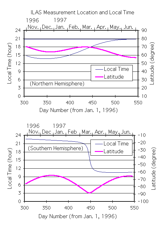
Figure 1.18 Temporal changes of ILAS latitude coverage and measurement location time for Northern (top) and Southern (bottom) Hemispheres [Sasano et al., 1999a]. The Northern and Southern Hemisphere measurements are provided by sunrise and sunset occultation events, respectively.
The major characteristics of the ILAS instruments are as follows: (1) grating spectrometers with linear array detectors: 1024-pixel MOS photodiode array for the visible channel and 44-pixel pyroelectric detector for the infrared channel; (2) in the visible the spectral coverage is 753 ~ 784 nm and resolution (full width at half maximum (FWHM)) 0.15 nm, in the infrared the spectral coverage is 850 ~ 1610 cm-1 (6.21 ~ 11.77 mm) with 0.12 mm FWHM; (3) instantaneous field-of-view at a tangent point: 1.6 km vertical * 2 km horizontal for the visible channel and 1.6 km vertical * 13 km horizontal for the infrared channel; (4) positioning: tracking radiometric centre of the sun from the tops of clouds up to 200 km; onboard instantaneous field-of-view position measurement relative to the sun edge with a resolution of 8 arc seconds provided by 1024-pixel linear array detector [Suzuki et al., 1995; Sasano et al.,1999a].
ILAS transmittance spectra (Level 1 data) for the infrared channels were simulated by considering the instrument characteristics, such as the instrument function, spectral resolution, signal digitisation, and cross talk among IR detector elements. The ILAS water vapour measurement is not expected to have strong interference from other gases; there are slight effects from CH4. Vertical profiles (Level 2 data) of gas mixing ratios are retrieved from the Level 1 data. A table look-up and interpolation method was adopted for calculating cross section values over a set of pressures and temperatures for the radiative transfer calculations. At the table look-up calculation stage, the spectral line parameters and cross sections were taken from the HITRAN 96 compilation. Calculations for the water vapour continuum were performed with the code CKD 2.1 supplied by Dr. Shepard A. Clough. The retrieval fits a theoretically synthesised spectrum to the observed spectra with a non-linear, least squares method and uses an onion peeling method for the vertical profiling of its gas components [Yokota et al., 1998; Sasano et al., 1999a].
An on-board calibration was performed for each occultation event as part of the Level 1 processing. A pseudo-transmittance spectrum was calculated from the measured signal, where the 0% level signal (bias) was estimated from a linear interpolation of deep space signals before and after the atmospheric scan. The 100% signal level was estimated from a linear extrapolation of the exoatmospheric Sun signals. The interpolation and extrapolation of the 0% and 100% signal levels for the atmospheric measurement period was done to reduce the uncertainties resulting from e.g., effects of changes in the instrument temperature.
The ILAS Project organised a number of validation experiments [Kanzawa et al., 1995; Kanzawa, 1997], including a balloon campaign at Esrange, near Kiruna, Sweden during the period from February to March 1997 - the main field experiment [Kanzawa et al., 1997]. A number of vertical profiles of water vapour as well as other gaseous species were obtained during that campaign.
The validation analyses of O3, HNO3, and aerosol extinction coefficient at 780 nm gave good results for Version 3.10 of the data processing algorithm [Sasano et al., 1999b; Lee et al., 1999; Koike et al., 2000; Burton et al., 1999]. ILAS Version 3.10 H2O compared well with data from the FISH hygrometer in the balloon campaign [Sasano et al., 1999c], but shows some shortages for H2O. Moreover, the Version 3.10 algorithm provided values larger than anticipated for N2O and CH4 in the lower stratosphere.
Version 4.20 data were released recently and are used in this report. Its data are of better quality. The major difference between Version 3.10 and 4.20 is due to how the sun-edge sensor measurements have been used to determine the tangent height. Version 3.10 relied on comparisons of measurements of the O2 A-band (P-branch) transmittance and its theoretical values based on UKMO assimilated temperature and pressure data, while Version 4.20 uses the sun-edge sensor data.
Error bars at each altitude for the retrieved parameters in Version 4.20 are presented in two classes: internal error and total error. Total error is the root sum of squares of the internal and external errors. "Internal" error for H2O is calculated from the final residuals from convergence in the non-linear least squares spectral fitting. External errors are the uncertainties of the model atmosphere used to correct for aerosol plus uncertainties in the temperatures used in the theoretical transmittance calculation. The total error is considered as the precision of the ILAS infrared gas products. There may be additional systematic errors that vary with altitude due to the ILAS tracking uncertainties, the exact location of the tangent altitude, and corrections for aerosols. Since the ILAS instrument function also varies depending on the changes in instrument temperature, which are correlated with the distance between the Sun and the Earth, the systematic error might have a small seasonal variation. Thus, the true accuracy could be worse than has been indicated by the estimates of total error given below. Comparisons with correlative or other satellite measurements provide a check on that possibility.
The Version 4.20 H2O data and its errors are given from about 10 km up to 70 km with an altitude resolution of 1 km. Average precision for all the H2O profile measurements from November 1996 through June 1997 is less than 10 % from 10-35 km, 10-30 % from 35-45 km, and over 30 % from 45-70 km. The vertical profile of the total error nearly agrees with estimates based on our simulations of precision. H2O data above about 35 km exhibit vertical oscillations that are larger than anticipated, most likely because of problems with our onion-peeling routine. Researchers should apply some averaging to the data with altitude to reduce those oscillations.
1.4.10 Polar Ozone and Aerosol Measurement (POAM III)
The Polar Ozone and Aerosol Measurement (POAM III) instrument is a satellite-based, nine-channel visible/near-infrared photometer for making measurements of aerosol extinction, ozone, water vapour, and nitrogen dioxide in the polar stratosphere using the solar occultation technique. The instrument is a follow-on to the successful POAM II experiment which obtained measurements from October, 1993, through November, 1996 [Glaccum et al., 1996 and Bevilacqua, 1997], and is similar in measurement technique and scientific capabilities to the Stratospheric Aerosol and Gas Experiment (SAGE) II instrument. The POAM III instrument is described in Lucke et al. [1999]. POAM III was launched on the French SPOT 4 spacecraft on 21 March 1998 into a polar, sun-synchronous orbit. The SPOT 4 orbit is identical to the POAM II orbit on SPOT 3 and provides 14 solar occultation profile measurements per day around a circle of latitude in each hemisphere, having successive observations separated by about 25 degrees longitude. The latitude of the observations varies slowly over the course of a year with an approximate semi-annual period. The latitudinal variation of the POAM III measurement coverage over a 1-year period (the coverage has nearly an exact annual periodicity) is shown in the top panel of Figure 1.19. The bottom panel gives the local time of the measurements. All POAM III Northern Hemisphere measurements are made during satellite sunrise, but at local sunset. All Southern Hemisphere observations are obtained during satellite sunset but at local sunrise from April through September and at local sunset from October through March. Transitions occur at the equinoxes.
The POAM water vapour measurement is made using the 940 nm water vapour absorption band. Specifically, the difference between the measured slant optical depth at 935.9 nm (on a water vapour feature) and 922.4 nm (off a water vapour feature) is used to retrieve the water vapour concentration as a function of altitude. The retrieved concentrations are converted to mixing ratio using United Kingdom Meteorological Office (UKMO) T/P profiles. The retrievals shown in this report were obtained using the POAM III Version 2 algorithm. This algorithm is very similar to the POAM II Version 5 algorithm described in detail by Lumpe et al. [1997], and to the POAM III Version 1.4 algorithm described in Lucke et al. [1999]. Briefly, the retrieval is performed in a 2-step process. In Step 1 the total slant optical depths for all POAM measurement channels are separated into their various species components. In Step 2 the species slant optical depths as a function of altitude are inverted to yield species concentration profiles. Both retrieval steps employ an optimal estimation approach. The retrieval is global in that all species (ozone, water vapour, nitrogen dioxide, and aerosol extinction) are retrieved simultaneously. The water vapour line strengths used in the retrieval algorithm to compute the absorption cross sections are taken from the HITRAN-96 data base and include the 14.4% correction (line strength increase) in the 940 nm absorption band that was reported by Giver et al. [2000]. The dependence of the cross sections on temperature, pressure, and absorber amount is treated using a mass-weighted Curtis-Godson approach.
The approximate water vapour retrieval altitude range is 10-40 km. The vertical resolution is about 1 km in the lower stratosphere. It broadens with increasing altitude above 30 km, becoming about 3 km at 40 km altitude. The water vapour precision is about 5% (1s ) from 16 to 40 km and better than 10% down to 14 km. The total systematic error is estimated to be better than 15% from 16 to 40 km. The dominant sources of error include random altitude registration uncertainties, incomplete sun spot removal, and aerosol extinction uncertainties. Residual contamination from the largest sunspots leads to errors as large as 20% at 20 km in individual profiles, increasing to 40% at 40 km. Aerosol extinction is mainly an issue in the presence of polar stratospheric clouds. Errors greater than 40% can occur at the altitude of the polar stratospheric cloud in individual profiles for the most optically thick clouds. The POAM measurements are made by solar occultation and are inherently self-calibrating (the fundamental measurements are optical depths). Thus, no further instrument calibration monitoring is required.
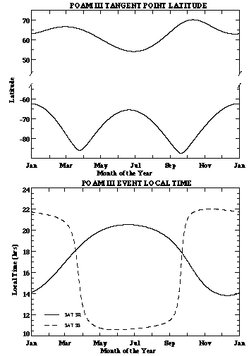
Figure 1.19 (top) POAM III measurement coverage at high latitudes of each hemisphere for a one-year period; (bottom) local time of measurement for Northern Hemisphere (solid) and Southern Hemisphere (dashed).