1.3 Ground based, balloon-borne and airborne remote sensing instruments
A number of remote sensing instruments are used to measure water vapour on balloons, aircraft, or from the ground. They are discussed in this Chapter separately from space-borne sensors because the spatial and temporal coverage of such measurements is more comparable to that of in-situ hygrometers.
Several instruments are presented based on techniques exploiting absorption or emission features in the IR and far-IR spectral region in order to measure vertical profiles of water vapour and many other species from balloons and aircraft. Generally, they use similar measurement geometry, and thus retrieval algorithms, as satellite experiments and are therefore a useful tool for their validation. LIDARs are based on a profiling technique. They have been applied to H2O measurements mainly at higher concentrations in the troposphere, but have recently also been extended to the lowest layers of the stratosphere. Microwave techniques are used for altitudes of the upper stratosphere and higher altitudes. As an independent technique, they provide useful information on the absolute H2O abundance in the stratosphere.
Remote sensing measurements can also be influenced by contamination problems when the payload is outgassing in the stratosphere. If the measurement is carried out from the troposphere, the large ‘background’ signal from the moist lower levels reduces the data quality or resolution for stratospheric measurements.
1.3.1 Microwave instruments
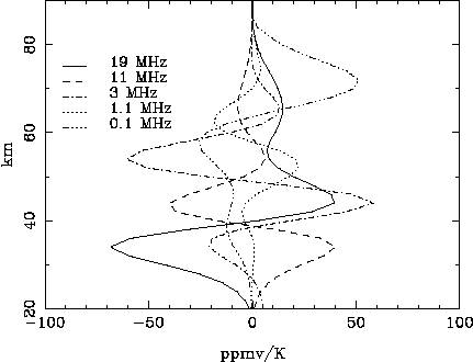
The retrieval of water vapour profiles as a function of altitude with ground-based and aircraft-based microwave instruments relies upon the sensitivity of the observed spectrum to pressure broadening. The line width of the spectrum decreases monotonically with altitude, and the resultant signal can be deconvoluted to retrieve a vertical profile. A retrieval of the mesospheric portion of the water vapour profile therefore relies primarily on the emission measurements very near to the centre of the emission line, while the stratospheric portion is determined primarily from emission measurements further from line centre (Figure 1.8a). While tropospheric water vapour emission dominates the total signal received at the ground, the large line width of this tropospheric signal makes it possible to separate this contribution from the middle atmospheric component of the emission.
While ground-based instruments necessarily must simultaneously observe all of the layers of the atmosphere, limb sounders can make use of a narrow beam, and thereby measure emission that contains a large contribution from a narrow layer of the atmosphere near the tangent height. In making comparisons between instruments with large differences in resolution, the effect of the resolution difference can be quantitatively assessed by creating a lower resolution profile (x) from the original high-resolution profile (xh). This is done by convoluting the higher resolution profile with the averaging kernels (A) of the lower resolution measurement, so that
x = Axh + (I-A)xa (1.8)
where I is the identity matrix [Rodgers, 1990]. xa is the a priori used in the lower resolution measurement, and the averaging kernels are determined by calculating the sensitivity of the lower resolution retrieval to changes in mixing ratio at different altitudes. A typical set of averaging kernels is shown in Figure 1.8b.
Figure 1.8a Each curve represents the change in the retrieved mixing ratio for a 1 K change in brightness temperature in a filter at the indicated frequency.
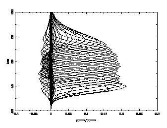
Figure 1.8b Each curve represents the change in the retrieved mixing ratio for a 1 ppmv perturbation at a given altitude. Dashed lines indicate kernels at 10 km increments.
Ground-based measurements of water vapour are generally made at 22.2 GHz, since this line is optically thin in the troposphere and thus allows continuous measurements of the middle atmosphere. At 22.2 GHz retrievals are possible up to ~80-90 km, at which point the Doppler broadening becomes greater than the pressure broadening. The 183 GHz line is usually optically thick in the troposphere, and can therefore be used for ground-based observations only at very high altitudes or when the troposphere is very dry. For aircraft-based measurements made from the stratosphere the strength of the 183 GHz transition makes it a better choice for water vapour observations. The line strengths of the 22.2 and 183 GHz transitions are taken from the calculated values given in the JPL spectral line catalogue [Pickett et al., 1998], and the line widths are taken from Liebe et al. [1993].
The microwave instruments described below are heterodyne spectrometers, i.e. they consist of a heterodyne receiver front end and a real-time spectrometer back end. In the heterodyne receiver the high frequency microwave radiation from the atmosphere is converted to a much lower frequency band. In this low frequency band electronic methods can be applied in order to perform spectral analysis with a resolution f/D f of 107 or even higher. Down-conversion creates two bands, the Lower Side Band (LSB) and the unwanted Upper Side Band (USB). The latter has to be suppressed, either by a wave guide filter (as for the MPAE instrument) or by an interferometer (as for the Bern instrument).
Because the intensity of the atmospheric microwave emission is very low, the receiver sensitivity is an important quantity. It is defined in terms of noise temperature TN, i.e. related to the emitted radiation ("noise") of a blackbody of a certain temperature. The atmospheric emission is defined in terms of brightness temperature, TB, of a blackbody. In general, TB is 1-3 orders of magnitude smaller than TN. For instance, TB of the water line at 22 GHz is about 1 K, while a state-of-the-art receiver’s sensitivity is about 100 K. The only way to resolve such an atmospheric line like water vapour is to average millions of water vapour spectra. This requires a real-time spectrometer. In a real-time spectrometer a time sequence t of the atmospheric radiation has to be processed within this time interval t . Three types of real-time spectrometers are used for the instruments described below: Filterbank (WVMS), Chirp Transform Spectrometer (MPAE) and Acousto-Optical Spectrometer (Bern).
The combination of a very sensitive receiver with a real-time spectrometer, i.e. a device, which measures chanel-to-chanel variations that are much smaller than the overall signal, is very sensitive to all kinds of systematic errors created by unwanted emissions and reflections in and around the system. One way to eliminate these is to calibrate the system using blackbodies at one or two well known temperatures (calibration loads), assuming that the systematic errors are the same when looking either on the blackbody or the atmosphere. The difference of the atmospheric spectrum and the flat blackbody spectrum then removes most of the systematic errors (see Equation 1.10 below).
For more details of microwave radiometry of the atmosphere the reader is referred to Janssen [1993].
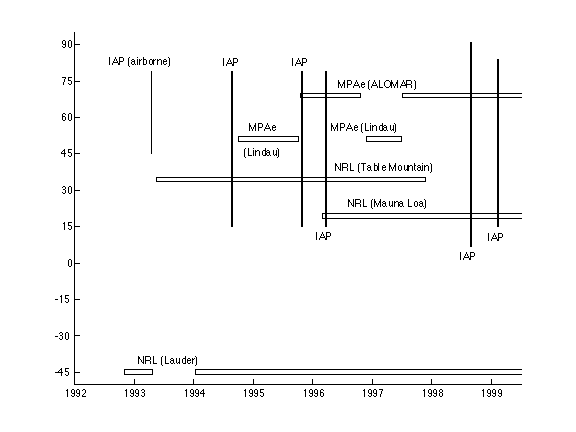
Figure 1.9 Microwave data sets of H2O obtained during the 1990s.
The Naval Research Laboratory (NRL) ground-based water vapour millimeter-wave spectrometer (WVMS)
The Water Vapor Millimeter-wave Spectrometer (WVMS) instruments make high spectral resolution measurements at 22.2 GHz, the emission frequency of the 616-523 rotational line of H2O. The radiometer is based on a High Electron Mobility Transistors amplifier which is refrigerated to 20K and provides 30 dB gained over a 500-MHz bandwidth. Radiation enters the radiometer through a scalar feedhorn that has a FWHM beam size of ª8°, after being reflected from an elliptical aluminium plate. A stepper motor rotates the aluminium plate that is inclined at a 45° angle to the axis of the motor and the horn, thus allowing variation of the measurement elevation angle. The WVMS2 and WVMS3 instrument spectrometers consist of a filter bank with thirty 14 MHz wide filters, thirty 2 MHz filters, twenty 200 kHz filters, and ten 50 kHz filters.
An estimate of the optical depth of the troposphere (ttrop) is obtained by tipping the instrument through 11 angles from 45° to 75° from zenith, using a high density of angles near 75° where the rate of change of air mass (m) as a function of angle is highest. To solve for the tropospheric optical depth NRL uses the measured system temperature from the widest filters (Tsys), estimate the receiver temperature and the atmospheric temperature (Trx and Tatm), and then solve for the tropospheric optical depth using a best fit to the equation
Tsys=Trx+Tatm (1-exp(-mttrop)) (1.9)
Following the determination of the tropospheric optical depth, the instrument observes for two ª 20 minute scans with the mirror switching between a near zenith (reference) and low elevation angle (signal) position. In the reference position a blackbody target at ambient temperature is placed in the field of view in order to noise balance the measurements in the signal and reference position. The difference between the signal and reference measurements is the fundamental quantity used in the retrievals. The measurements are calibrated with a noise diode, which is itself calibrated weekly by alternately placing an ambient temperature and a liquid nitrogen load in front of the feedhorn. An optimal estimation technique [Rodgers, 1976] is used for the retrievals. Details of the measurement and retrieval technique are discussed in Nedoluha et al. [1995] and Nedoluha et al. [1996].
Three WVMS instruments have been in operation, providing nearly continuous measurements of water vapour from ª40-80 km. An integration time of ª 1 week is required in order to achieve adequate signal-to-noise for retrievals at 80 km, while in the stratosphere daily retrievals are possible. For weekly retrievals the random error is estimated to be 4-7%, with the largest error at the highest altitudes. The altitude resolution is ª 10 km, and systematic uncertainties are ª 5-10%. The systematic uncertainties arise primarily from errors in the calibration and pointing. Uncertainties in the derived linear trends can be estimated from the accuracy to which the calibration and pointing can be re-established whenever repairs or improvements are made to the system. It is estimated that over a 4-5 year period the uncertainty in the derived linear trend is ~1% of the mixing ratio. Data is available from three sites, listed in Table 1.13.
Table 1.13 Measurement history of WVMS
|
|
|
| Table Mountain, CA (34.4oN, 242.3oE) |
|
| Lauder, New Zealand (45.0oS, 169.7oE) |
03 Nov 1992 - 21 Apr 1993 14 Jan 1994 to present |
| Mauna Loa, Hawaii (19.5oN, 204.4oE) |
|
The MPAE ground-based microwave spectrometer (WASPAM)
The ground-based microwave spectrometer of the Max Planck Institut für Aeronomie (MPAE), the WASPAM (Wasserdampf und Spurengasmessungen mit Mikrowellen) experiment [Hartogh and Jarchow, 1995], observes the same water vapour transition as the WVMS, i.e. 22.235 GHz and the water vapour continuum at 31.5 GHz. A rotating mirror reflects the microwave radiation of the atmosphere, a cold load and a hot load alternately to a polarisation grid. While one polarisation passes the grid into the horn antenna of the 31.5 GHz receiver, the other polarisation is reflected via an elliptic mirror to the horn antenna of the 22 GHz receiver. The signal level is amplified by about 30 dB using three High Electron Mobility Transistors. The amplifier covers the frequency range of 20 to 24 GHz and is cooled to 20 K by a closed Helium loop. A steep low-pass filter at the output of the amplifier cuts off all frequencies above 22.5 GHz. The single sideband (SSB) receiver temperature is about 100 K. The filtered signal is down-converted to 300 MHz using a local oscillator frequency of 22.535 GHz and then applied to a 1.5 GHz wide amplifier. A Chirp Transform Spectrometer (CTS) with 2048 channels of 21 kHz resolution (i.e. 43 MHz bandwidth) performs the spectral analysis. The input centre frequency of the CTS is 300 MHz. The USB rejection is better than 15 dB. The CTS provides spectra every 47 µs. 128000 of these spectra are averaged, i.e. data are stored in 6-second intervals. The hot load consists of a microwave absorber temperature-stabilised to 300 K. The cold load consists of a microwave absorber cooled by a second closed helium loop and provides a brightness temperature of 77 K. The microwave window of the cold load consists of HDPE 1000 and is matched to 22.235 GHz. The brightness temperature of the atmosphere is calculated using
Tatm = [(Patm-Pcold)/(Phot-Pcold)]*(Thot-Tcold)+Tcold. (1.11)
P denotes the relative power output of the spectrometer in the three mirror positions, Thot and Tcold are the temperatures of the calibration loads. This approach works well for this system due to the excellent linearity of the CTS.
The atmospheric radiation is received with a fixed elevation angle of 18 degrees and a beam width of 7 degrees FWHM. The tropospheric transmission is derived from the measured brightness temperature in the line wings of the water vapour line, assuming that the troposphere is a single layer with a constant temperature. It can been shown that the error of this approach is negligible for low brightness temperatures of the atmosphere and small line amplitudes [Jarchow, 1998]. This is also the case for the water vapour measurement at 22 GHz.
Two retrieval techniques have been applied to determine altitude profiles of water vapour from the measured spectra: the approach by Backus and Gilbert [1970] and the optimal estimation technique [Rodgers, 1976]. While the latter gives the best results when retrieving single spectra, for instance for a weekly or monthly mean, the former has advantages for retrieving continuous data sets, especially when there are large variabilities in the tropospheric transmission [Jarchow and Hartogh, 1995]. The altitude coverage of the data is 35 to 85 km. For weekly retrievals in the altitude range of 40-80 km the random error is estimated to be 0.15 ppmv. The altitude resolution is about 10 km. The systematic errors range between 0.1 ppmv at 80 km and 0.5 ppmv at 40 km. The main source of systematic errors, the so-called baseline, occurs due to reflections in the receiver. The contribution of pointing errors to the total systematic error is negligible for our system. A detailed error analysis is described in Jarchow [1998].
The 22 GHz system provided the first useful data in 1993. It has been in almost permanent operation since 1994 at mid-latitudes [Hartogh and Jarchow, 1995] and since 1995 in the Arctic [Seele and Hartogh, 1999] (Table 1.14).
A 183 GHz system has been developed and used from 1991 until 1994 [Hartogh et al., 1991]. The system consists of a Schottky receiver cooled to 20 K with a single sideband (SSB) noise temperature of 500 K and a combined filterbank (28 channels, 1.2 GHz bandwidth)/CTS (1024 channels, 40 MHz bandwidth) back-end. Most of the time the system has been operated from MPAE, a site with only moderate microwave observation conditions (140 m altitude). Therefore, only a few useful profiles of middle atmospheric water vapour during mid-February 1993 have been obtained. The advantage of the 183 GHz measurement is that once the line can be observed it is likely to be much stronger than the 22 GHz line and therefore much less sensitive to baselines. As a result water vapour can be retrieved down to altitudes of 20 or even 15 km. Hartogh et al. [1994] showed that ground-based water vapour data at 183 GHz can be obtained from central European measurement sites above 3000 m altitude for more than 100-150 days per year.
Table 1.14 Measurement history of MPAE instruments
| Measurement Site |
|
|
| Lindau, Germany (51oN, 10oE) |
|
|
| Lindau, Germany (51oN, 10oE) |
|
01 Oct 1994 - 5 Oct 1995 27 Nov 1996 - 27 Jun 1997 |
| ALOMAR (69oN, 16oE) |
|
15 Oct 1995 - 21 Oct 1996 6 Jul 1997 to present |
Microwave radiometry of water vapour from aircraft
If microwave observations of H2O are performed above the troposphere, from aircraft or balloons, the transition at 183.310 GHz is much better suited as its line strength is stronger by two orders of magnitude than the 22.235 transition. The brightness temperature for the 183 GHz line observed from aircraft is approximately 100 K in contrast to that measured from the ground at 23 GHz that is only a few tenths of a degree. Therefore the integration time of a microwave receiver will be much shorter for the stronger line. This offers the opportunity to deduce latitudinal variations of water vapour if observed from a moving platform. For this reason a microwave radiometer for operation from aircraft was built at the University of Bern several years ago and used in a first test flight in 1984 followed by an aircraft campaign in 1988 [Peter et al., 1988]. The instrument has been modified and optimised since then and used in new campaigns in the nineties [Peter and Kämpfer, 1994; Peter, 1998a; Peter, 1998b, see also Kämpfer, 1995, for a review of the techniques used at the University of Bern in Switzerland]. These campaigns, which took place in different seasons, offered the opportunity to investigate the seasonal and latitudinal variability of water vapour from the subtropics to the Arctic. An overview of the campaigns performed so far with an indication of the latitudinal coverage is given in Table 1.15. The instrument also has been modified for use together with a submillimeter receiver for the detection of ClO, HCl and O3. Today the instrument with its millimetre receiver for water vapour offers a very reliable and easy to use instrument which can be incorporated in a Learjet for campaigns within a few hours.
Table 1.15 Summary of the aircraft campaigns of the Bern microwave radiometer
|
|
|
|
| 02 - 04 Dec 1986 | Northern Europe, 45N to75N | Peter et al., 1988 |
| 13 - 15 Apr 1993 | Northern Europe, 46N to 78N | Peter and Kämpfer, 1994 |
| 22 - 25 Aug 1994 | 16N / 23W to 78N / 18E | Peter, 1998a; Peter,1998b |
| 23 - 26 Oct 1995 | 16N / 23W to 78N / 18E | Peter, 1998a; Peter,1998b |
| 18 - 21 Mar 1996 | 16N / 23W to 78N / 18E | Peter, 1998a; Peter,1998b |
| 24 - 28 Aug 1998 | 8N / 14W to north pole | |
| 05 - 12 Feb 1999 | 17N / 23W to 81N / 16E | |
| 08 - 14 Mar 2000 | 29N / 40W-28E to north pole |
The University of Bern system consists of a heterodyne receiver with an uncooled Schottky diode mixer that converts the high frequency signals to an intermediate frequency of 3.7 GHz. The radiometer has a single sideband system temperature of 4000 K. A Martin-Puplett interferometer acts as a filter to suppress the unwanted sideband. This sideband filter can be tuned to measure alternately in either of the two sidebands around 183.3 and 175.9 GHz that enables measurement of radiation in the very far wing of the water vapour line. Side band switching is controlled by the onboard computer. A rotating mirror switches the instrument's field of view approximately every 1.5 seconds between the atmosphere at an elevation angle of 15° and two microwave absorbers at temperatures of 77 K and 312 K, that serve as calibration loads. The intermediate frequency signal is analysed simultaneously with two acousto-optical spectrometers (AOS). One AOS has a large bandwidth of 1 GHz and a resolution of 1.2 MHz. It is well suited for the observation of spectral lines from the stratosphere. The second AOS has a total bandwidth of 50 MHz at a high resolution of 50 kHz. It is used for the analysis of narrow spectral lines emitted from the mesosphere. Furthermore, the instrument has its own independent GPS receiver to record position and altitude for each measurement.
Water vapour profiles are retrieved between 15 km and 75 km with an altitude resolution of approximately 8 km in the lower stratosphere and approximately 15 km in the upper mesosphere. The root sum square of all error contributions is below 0.6 ppmv.
1.3.2 Water vapour LIDAR
Water vapour can be measured by using either the DIfferential Absorption LIDAR (DIAL) or the Raman LIDAR techniques. The advantage of LIDAR (LIght Detection And Ranging) methods is that range-resolved water vapour measurements can be made at a high resolution during day or night. LIDAR systems can be operated in spectral regions that avoid interference from absorption by other species and LIDAR retrievals require fewer assumptions than those for passive techniques and do not require complex inversion algorithms.
Differential Absorption LIDAR (DIAL)
In the DIAL technique, two laser pulses are transmitted into the atmosphere, one at the peak of the absorption line called the "on-line" and another in the wing of the absorption line called the "off-line". Using the DIAL method, the average molecular number density between ranges R1 and R2 is calculated using the relation:
![]() (1.11)
(1.11)
where n is the average water vapour number density between the ranges R1 and R2, S is the LIDAR signal, and Ds is the differential absorption cross-section between the on- and off-lines. The D s values are computed from the line parameters for water vapour lines in the near visible region measured using high resolution spectroscopic techniques [Grossmann and Browell, 1989, and Ponsardin and Browell, 1997]. The DIAL method provides a self-calibrated absolute water vapour measurement capability. The DIAL technique can be used to directly obtain the concentration profile of water vapour using the LIDAR signals and D s. This method for water vapour uses single absorption lines that are typically 10 pm wide. DIAL measurement simulations involving these narrow absorption lines show that the quality of laser spectral radiation has to be controlled very well in order to avoid undesirable systematic influences [Ismail and Browell, 1989]. In addition, the signals and D s are influenced by a number of atmospheric and instrumental effects that need to be taken into consideration during the operation of DIAL and during data analysis [Ismail and Browell, 1989]. For example, gradients in the atmospheric aerosol scattering, Doppler broadening and the near range LIDAR overlap region present challenges in DIAL data reduction [Bosenberg, 1998].
The advantage of the DIAL method is that in addition to measuring gas concentration profiles, high spatial resolution aerosol back-scattering distributions are simultaneously obtained as part of the DIAL measurement using the off-line LIDAR signals. The vertical and/or horizontal resolution can be adjusted in the DIAL analysis by changing how the high-resolution LIDAR data are averaged. With the DIAL method, LIDAR measurements can be made during day or night and in between and up to cloudy regions in the atmosphere.
The first detection of water vapour using the DIAL technique was made in 1966 [Schotland, 1966] with a laser system that had a fortuitous coincidence with a water vapour absorption line. The DIAL technique for water vapour measurements using tuneable lasers was demonstrated from the ground by Browell et al. [1979], and subsequently by Cahen et al. [1982] and Bosenberg [1987]. The first airborne measurements of water vapour came in 1981 [Browell et al., 1984], and this was followed by subsequent airborne measurements [Ehret et al., 1993, Higdon et al., 1994]. A ground-based water vapour DIAL for the lower troposphere has been developed and operated in Germany [Wulfmeyer and Bosenberg, 1998]. The DIAL method can be used for long-range measurement of water vapour. However, because of the high absorption of the on-line in the lower troposphere, airborne DIAL systems are more suitable for water vapour measurements in the nadir-viewing mode and from space.
The LaRC airborne DIAL system, LASE
Following a long history of ground-based and airborne water vapour DIAL developments (discussed in the previous section), the NASA Langley Research Center developed the first autonomously operating DIAL system for the measurement of water vapour and aerosol profiles across the entire troposphere. This system, called LASE (LIDAR Atmospheric Sensing Experiment), is a compact DIAL system that was initially developed for operation from a high-altitude ER-2 aircraft, and in 1995, LASE completed its development and validation phases [Browell et al., 1997]. LASE operates in the 815-nm absorption band of water vapour and it uses a Ti:sapphire laser that is locked onto a strong and temperature insensitive water vapour line. The spectral characteristics of the water vapour lines are documented [Ponsardin and Browell, 1997] and the lines are chosen to have a residual temperature sensitivity of less than a few percent [Ismail and Browell, 1989]. Water vapour over the entire troposphere is measured by electronically tuning the on-line to operate at any spectral location of the water vapour absorption line profile. This is done by first locking to the line centre and then adjusting the diode current a know amount from the line centre before the Ti:sapphire laser is fired. Since the actual water vapour line is used to lock the diode and the known spectral properties of the absorption line, the LASE water vapour measurement is self-calibrated.
LASE was operated autonomously from the NASA ER-2 aircraft during flight experiments from 1994 to 1996. It has also been configured to fly on the NASA P-3 and DC-8 aircraft. LASE has demonstrated the capability to measure water vapour over the entire troposphere [Browell et al., 1997] with an accuracy of 6% or 0.01 g/kg. The horizontal resolution of LASE water vapour measurements is about 24 km (or two minutes of data averaging) and vertical resolutions of 300 m and 500 m in the lower and upper troposphere, respectively. LASE has participated in five major field experiments during 1995-1999; a list of these field experiments is given in Table 1.16. Archived data from these experiments are available from NASA Langley Distributed Data Archive Centre (DAAC) at http://eosweb.larc.nasa.gov/HPDOCS/index.html.
Table 1.16 LASE field experiments from 1995-2000
| Date | Experiment | Base of operations | Latitude | Longitude | Altitude |
| Sep 1995 | LASE Validation Experiment | Wallops Island, VA | 29-42N | 63-86W | 0-15 km |
| Jul 1996 | TARFOX | Wallops Island, VA | 32-39N | 72-77W | 0-15 km |
| Jul 1997 | SGP97 | Oklahoma City | 34-38N | 97-99W | 0-7 km |
| Aug/Sep 1998 | CAMEX-3 | Cocoa Beach, FL | 16-41N | 63E-86W | 0-14 km |
| Mar/Apr 1999 | PEM B | Hawaii, Fiji, Tahiti | 36S-34N | 87-197W | 0-14 km |
| Dec1999-Mar2000 | SOLVE | Kiruna, Sweden | 57-90N | 100W-100E | 0-14 km |
The DLR airborne water vapour DIAL
At DLR (Deutsches Zentrum für Luft- und Raumfahrt) in Oberpfaffenhofen, Germany, airborne water vapour DIAL systems have been operated since 1989 [Ehret et al., 1993]. The first H2O DIAL was operated in the near infrared spectral region at 724 nm and was routinely installed nadir viewing onboard the DLR’s meteorological research aircraft Falcon 20 and later modified for operation onboard the NCAR Electra research aircraft. This system took part in several field experiments to investigate processes in the boundary layer.
In order to increase both accuracy and spatial resolution, and to be sensitive for water vapour measurements in the stratosphere, a new water vapour DIAL system has been developed at DLR. Based on a high peak and average power optical parametric oscillator, its transmitter fulfils the spectral requirements for water vapour measurements in the troposphere as well as in the stratosphere [Ehret et al., 1998]. The residual systematic error caused by the spectral properties of the new radiation source amounts to only 2%. The transmitter is designed to be operated at either the weak 4n vibrational absorption band of water vapour near 830 nm, suitable for tropospheric measurements, or at the 3n vibrational absorption band lying in the 940 nm spectral region which is one order-of-magnitude stronger. The latter has the advantage of much higher measurement sensitivity in regions of low water vapour content at upper tropospheric and lower stratospheric heights. The spectroscopic parameters of the relevant water vapour absorption lines at 940 nm were measured in the lab [Poberaj and Weiss, private communication, 1999].
The new DLR H2O DIAL can be used for measurements of water vapour in the range from 5-100 ppmv [Ehret et al., 1999]. In the downward looking mode it can scan vertical cross sections of up to 6 km in range, with a resolution of about 20 km in the horizontal and 250-500 m in the vertical. In 1999, this system participated in the Mesoscale Alpine Programme (MAP´99) field campaign (Table 1.17) in order to investigate strong horizontal and vertical gradients of the water vapour profile at tropopause level.
Table 1.17 DLR´s water vapour DIAL field experiments
| Time | Experiment | Latitude | Longitude | Altitude | Remarks |
| Nov 1998 | Validation experiment | 44-48N | 0-12E | 6-12 km | 10 Hz transmitter |
| Oct/Nov 1999 | MAP 99 | 44-52N | 2W-14E | 5-12 km |
100 Hz transmitter PV-streamers over Central Europe |
Raman back-scatter LIDAR
The Raman LIDAR technique uses the relative intensity of vibrational Raman scattering from water vapour and nitrogen to make a direct measurement of mixing ratio [Melfi et al., 1969, Cooney, 1970]. The technique is relatively free of systematic errors (e.g. aerosol effects) and can be operated from the ground because the radiation is not absorbed by water vapour in the lower troposphere. It is versatile, allowing studies of cloud liquid water and droplet radius, direct measurement of cirrus cloud optical depth, and direct measurement of aerosol extinction [Whiteman and Melfi, 1999]. Its disadvantage is the very weak Raman scattering cross-section, which has traditionally meant a long averaging time (several hours) for a precise measurement near the tropopause [e.g. Vaughan et al., 1988]. However recent systems based on excimer lasers have extended the Raman technique to the tropopause [Ansmann et al., 1992].
The ratio of the Raman back-scatter signals from water vapour SW and molecular nitrogen SN collected simultaneously on the same receiving telescope is proportional to the water vapour mixing ratio W (specific humidity) [Whiteman et al., 1992]
W = K. SW/SN (1.12)
The LIDAR calibration coefficient K is the product of two terms - a system independent term describing the ratio of the molecular masses of H2O and N2 and the mixing ratio of N2 in dry air (0.78), and a system-dependent term describing the product of the Raman back-scatter cross sections with the instrument function.
The Raman back-scatter signals SW and SN are corrected for differential atmospheric attenuation, photomultiplier nonlinearity and background noise. The atmospheric differential attenuation correction is calculated using standard atmosphere models, complemented with boundary layer aerosol extinction measurements where necessary. The LIDAR calibration coefficient can (and should) be determined independently. In practice it is typically deduced from a least squares regression of a simultaneous co-located radiosounding. The LIDAR water vapour measurement is temperature-independent for all practical purposes.
Most Raman LIDARs have been calibrated by fitting the ratio profiles to radiosonde humidity profiles. Ferrare et al. [1995] and Wang et al. [1995] compared water vapour measurements made by the NASA Goddard Space Flight Centre (GSFC) Raman LIDAR (see below) and radiosondes (both AIR and Vaisala). Agreement between LIDAR and radiosondes was generally good up to 8 km, but the calibration constant (determined by the average LIDAR/sonde ratio) varied from sonde to sonde. There is a clear need for further work in this area to characterise the performance of both LIDARs and sondes.
An absolute calibration is possible [Vaughan et al., 1988, Sherlock et al., 1999a]. This calibration is ultimately limited to ± 6% by spectroscopic uncertainties. However, changes of the calibration coefficient over time can in principle be monitored with a precision of 4 to 6% [Goldsmith et al., 1998; Sherlock et al., 1999a; Turner et al., 1999]. In the upper troposphere the precision error dominates for an individual profile, unless the signals are averaged over many hours when variability in the humidity itself becomes a major concern.
Several Raman LIDAR systems have been operated from the ground over 30 years. In this report, the NASA/GSFC and OHP systems are described as examples, data will only be shown for the NASA/GSFC Raman LIDAR. Further, the US Department of Energy (DOE) has set up an operational Raman LIDAR system at the DOE Atmospheric Radiation Monitoring site in Lamont, Oklahoma [http://dev.ec.arm.gov/~turner/raman_lidar_quicklooks.html for data images; Goldsmith et al., 1998]. Turner et al. [1999] have discussed the systematic influences in Raman LIDAR systems, and they have also described procedures for correcting them to retrieve water vapour profiles. Several European institutions have also developed Raman LIDAR systems for tropospheric water vapour measurements [Renaut et al., 1980; Weitkamp et al., 1986; Vaughan et al., 1988; Mattis et al., 1998].
The GSFC Raman LIDAR
At the NASA Goddard Space Flight Center, Raman LIDAR have been developed and operated since the 80s [Melfi and Whiteman, 1985; Whiteman et al., 1992]. The present NASA/GSFC Scanning Raman LIDAR is housed in a single mobile trailer and has participated in numerous field campaigns since its first deployment in 1991. The system has received several modifications since that time and now contains two lasers for optimised performance during either nighttime or daytime [Whiteman and Melfi, 1999]. For nighttime operation, an excimer laser with an output wavelength of 351 nm is used. The return wavelengths for water, nitrogen and oxygen are 403, 382 and 371 nm, respectively. They are collected by a telescope and detected by eight photomultipliers (two for each wavelength, for different altitude ranges) tubes using dichroitic beamsplitters and interference filters. To facilitate daytime measurements, SRL uses a Nd:YAG laser in combination with frequency-tripling optics transmitting pulses at 355 nm.
The precision for ground-based measurements is typically quoted as <10% up to 8 km with 1 minute averaging and 75 m vertical resolution (night-time). The daytime precision is 10% random error at 4 km using 10 minute average.
Table 18 Field deployment of Scanning Raman Lidar
| Campaign | Dates | Longitude | Latitude |
| SPECTRE | 13 Nov - 07 Dec 1991 | 37.1N | 95.6W |
| ATMIS-II | 15 Jul - 06 Aug 1992 | 37.8N | 75.5W |
| CAMEX-1 | 13 Sep - 06 Oct 1993 | 37.8N | 75.5W |
| ARM | 15 Apr - 01 May 1994 | 36.6N | 97.5W |
| LITE | 10 - 21 Sep 1994 | 38.8N | 76.7W |
| CAMEX-2 | 25 Aug - 21 Sep 1995 | 37.8N | 75.5W |
| TARFOX | 10 - 31 Jul 1996 | 37.8N | 75.5W |
| ARM | 10 - 30 Sep 1996 | 36.6N | 97.5W |
| ARM | 15 Sep - 04 Oct 1997 | 36.6N | 97.5W |
| CAMEX-3 | 06 Aug - 23 Sep 1998 | 24.7N | 77.8W |
The OHP Raman LIDAR
The Raman backscatter water vapour measurement at the Network for Detection of Stratospherci Change (NDSC) station at the Observatoire de Haute Provence (OHP, 44°N, 6°E) operates on a routine basis at night except in the presence of low cloud [Sherlock et al., 1999b]. From July 1997 - March 1998, 300 profiles were obtained. The instrument provides vertical profiles of water vapour from 2 km to the tropopause and/or specific humidity less than or equal to 1x10⁻⁵ g/g dry air. With a temporal integration of 1 to 2 hours and a vertical resolution ranging from 75 meters at and below 7 km to 375 meters at 11 km the random measurement error is of the order of 10% in the mid troposphere increasing to 20 to 30% in the upper troposphere. The systematic error in measurement is less than or equal to 2x10⁻⁶g/g dry air, and the instrumental response varies by -0.02%/K. The OHP LIDAR system uses a 532.1 nm exciting wavelength, OH-rich fibre optic cables for signal transfer and Q-branch signal selection. These instrumental characteristics minimise the atmospheric transmission correction, the background noise, and the systematic measurement errors, and improve short-term instrumental stability.
The OHP LIDAR system is calibrated both independently and with co-located radiosoundings [Sherlock et al., 1999a]. Current calibrations have an associated error of the order of 10%. The implementation of means to improve the accuracy of the independent calibration is envisaged in the near future.
1.3.3 Infrared and far infrared measurements of H2O
Water vapour in the middle atmosphere can be well measured by passive remote sensing in the infrared. Appropriate absorption lines of H2O are available from the near to the far infrared. Corresponding spectrometers detect either the attenuated solar radiation or the emitted radiation of the atmosphere. By inverting the radiative transfer equation, atmospheric parameters such as the temperature and trace gas mixing ratios can be determined from the radiance measurements.
Profile measurements above the location of the instrument are possible in principle with spectrally highly resolving instruments, but the upper level of the altitude range depends on the wave number (for 1000 cm-1 at about 30 km and for 100 cm-1 at about 48 km). This is caused by the fact that the shape of the absorption lines is dominated by the Doppler effect above this height level. In the case of H2O it is even more difficult to sound the stratosphere from the ground because there is only a small amount of the H2O column above the tropopause. In order to achieve profiles with good vertical resolution in the middle atmosphere the limb sounding technique, i.e. viewing the atmosphere along tangential slant paths, has to be applied from balloon gondolas or high flying aircraft. Vertical profiles can in addition be derived from up-looking measurements during ascent or descent of the balloon or the aircraft.
In the case of limb sounding, the profiles of trace gases are determined from several measurements with different elevation angles, thus sensing the various atmospheric layers with different weighting. Inversion methods used are e.g. the onion peeling or the global fit technique [e.g. Goldmann and Saunders, 1979]. In the first case the atmosphere is peeled like an onion starting with the highest layer and working through the atmosphere to the lowest layer. Performing a global fit involves using all the measured spectra in one non-linear least-square fit in order to generate the vertical profile of the trace gas under investigation. If, in addition, a priori knowledge of the atmosphere is taken into account, the retrieval procedure is called optimal estimation technique.
A number of infrared spectrometers from different laboratories have been used from balloons and aircraft so far. Since the technique allows the determination of vertical distribution of many atmospheric trace constituents, these experiments were not usually designed primarily for the H2O retrieval. Below, three instruments are described; information on other IR spectrometers from which H2O profiles have been derived is found in Murcray et al. [1990] and references therein.
The MIPAS balloon and aircraft experiments
Several Fourier Transform Infrared (FTIR) spectrometers, known as MIPAS (Michelson Interferometer for Passive Atmospheric Sounding), using a special configuration to provide the optical path difference, have been developed for operation on ground, aircraft, and stratospheric balloon gondolas by the Institut für Meteorologie und Klimaforschung in Karlsruhe, Germany (for a review see Fischer, 1993).
A cryogenic balloon-borne version of MIPAS (called MIPAS-B) was developed to measure vertical profiles of a comprehensive set of stratospheric chemical compounds that are relevant for ozone chemistry and climate research. The instrument is specially tailored for operation on a stratospheric balloon gondola and equipped with suitable subsystems to precisely allow limb emission sounding of the stratosphere independent of external radiation sources. As such it can be operated day and night, not being restricted to any solar zenith angle. MIPAS-B is the only cryogenic limb emission FTIR sensor in routine operation worldwide. A first version was flown between 1989 and 1992 twice during spring turn-around and twice near the northern polar circle inside the vortex in winter (Fischer and Oelhaf, 1996, and references cited therein).
A second version (MIPAS-B2) was built in 1993/94 that incorporated many improvements such as increased spectral coverage (Friedl-Vallon et al., 1995, Oelhaf et al., 1996). The interferometer provides two-sided interferograms with a maximum optical path difference of 15 cm, resulting in an unapodized spectral resolution of 0.033 cm-1. The four-channel detector system with Si:As detectors allows the simultaneous coverage of the most important absorption bands of ozone- and climate-relevant trace gases between 5 and 14 m m. Typical signal-to-noise ratios of single H2O lines are between 50 and 200. A novel solution has been realised for the line-of-sight stabilisation and reference system that provides tangent heights to better than 200 m (3s ). Radiometric calibration is performed on the basis of blackbody and deep-space spectra that are recorded several times during flight. The calibrated spectra are analysed using multi-parameter non-linear least-square curve fitting in combination with the onion-peeling technique (see e.g. von Clarmann et al., 1995, Wetzel et al., 1997 and references therein). The estimation of the error budget is carried out using an elaborate scheme that takes into account random noise, mutual influence of fitted parameters, temperature and pointing uncertainties, onion-peeling error propagation, and errors in spectroscopic data. MIPAS-B is suitable to simultaneously obtain vertical profiles of ozone and a considerable number of species such as O3, NO, NO2, HNO3, HO2NO2, N2O5, ClONO2, COF2, CH4, N2O, H2O, HDO, CF2Cl2, CCl3F, CHF2Cl, CCl4, CF4, C2H6, and SF6 with an altitude resolution of 2-3 km. The precision of the retrieved H2O mixing ratio is typically near 5% with temperature errors being the dominant source of errors, and the absolute accuracy of H2O profiles derived from MIPAS-B2 spectra is between 6 and 11% assuming a 5% uncertainty of the spectroscopic data.
Since 1995, MIPAS-B2 was flown 5 times in polar regions in winter and spring and 3 times at mid-latitudes during spring and summer (Table 1.19). Water vapour profiles were retrieved along with profiles of methane and deuterated water from MIPAS-B2 [Stowasser et al., 1999]. From these MIPAS-B2 data the hydrogen budget ([H2O] + 2[CH4]) was also derived.
Table 1.19 Balloon flights with the MIPAS-B2 instrument
|
|
|
|
|
|
|
| 11 Feb 95 | Kiruna/Sweden - 68°N | 29.1 km | 10 - 28 km | SESAME | inside vortex |
| 21 Mar 95 | Kiruna/Sweden - 68°N | 28.9 km | 10 - 28 km | SESAME | inside vortex |
| 10 Feb 97 | Kiruna/Sweden - 68°N | 29.3 km | 11 - 29 km | CHORUS | inside vortex |
| 24 Mar 97 | Kiruna/Sweden - 68°N | 30.0 km | 11 - 29 km |
CHORUS/ ILAS |
inside vortex ILAS validation |
| 02 Jul 97 | Gap/France - 45°N | 39.4 km | 7 - 39 km | CHELOSBA | vortex remnants |
| 08 May 98 | Aire sur l‘Adour/F - 44°N | 38.4 km | 8 - 38 km | CHELOSBA | |
| 27 Jan 99 | Kiruna/Sweden - 68°N | 32.5 km | 3 - 32 km | THESEO | inside vortex |
| 30 Apr 99 | Aire sur l‘Adour/F - 44°N | 38.2 km | 0 - 38 km | THESEO |
An instrument similar to MIPAS-B was flown on a Transall aircraft (MIPAS-FT) during the first half of the 1990s [Gulde et al., 1994]. Observations were made from the low flying aircraft through a window by upward sounding at an elevation angle of 7°. As a consequence, only column amounts of different trace species have been determined. More recently a MIPAS instrument has been completed for use aboard the stratospheric aircraft M55 Geophysika. This MIPAS-STR is also a limb sounder like MIPAS-B and therefore delivers vertical profiles of various trace gases, among others H2O, in the lower stratosphere. After a series of test flights in spring 1999 an Antarctic field measurement campaign followed in autumn 1999.
The JPL MkIV interferometer
The Jet Propulsion Laboratory MkIV interferometer is a high resolution Fourier Transform InfraRed spectrometer, designed to remotely sense atmospheric composition [Toon, 1991]. This instrument is very similar to the ATMOS instrument (Section 1.4.4) which flew during four missions on the Space Shuttle. The MkIV instrument made ground-based observations from McMurdo, Antarctica, in September and October 1986, and flew on board the NASA DC-8 aircraft for the 1987 Antarctic polar campaign (AAOE) and the Arctic polar campaigns (AASE) of 1987 and 1992. Additionally, it has made 17 flights from high altitude research balloons since 1989 (Table 1.20).
Table 1.20 Summary of MkIV balloon flights
| Date | Tangent latitude | Tangent longitude | Minimum altitude | Balloon altitude |
Launch site | Observation mode |
| 05 Oct 89 | 34.6N |
105.7W
|
|
37 km | New Mexico | sunset |
| 27 Sep 90 | 34.2N |
106.0W
|
|
36 km | New Mexico | sunset |
| 05 May 91 | 37.5N |
111.8W
|
|
37 km | New Mexico | sunset |
| 06 May 91 | 36.5N |
103.0W
|
|
32 km | New Mexico | sunrise |
| 14 Sep 92 | 35.2N |
110.2W
|
|
38 km | New Mexico | sunset |
| 15 Sep 92 | 35.3N |
103.9W
|
|
40 km | New Mexico | sunrise |
| 3 Apr 93 | 34.8N |
115.5W
|
|
37 km | California | sunset |
| 25 Sep 93 | 34.0N |
109.4W
|
|
37 km | New Mexico | sunset |
| 26 Sep 93 | 33.2N |
100.4W
|
|
38 km | New Mexico | sunrise |
| 22 May 94 | 36.6N |
109.7W
|
|
36 km | New Mexico | sunset |
| 23 May 94 | 36.3N |
100.8W
|
|
37 km | New Mexico | sunrise |
| 24 Jul 96 | 56.8N |
101.0W
|
|
24 km | Manitoba | ascent |
| 08 May 97 | 68.0N |
147.0W
|
|
38 km | Alaska | sunrise |
| 08 Jul 97 | 67.0N |
148.0W
|
|
32 km | Alaska | ascent |
| 09 Jul 97 | 65.0N |
150.0W
|
|
32 km | Alaska | descent |
| 03 Dec 99 | 64.0N |
19.0E
|
|
33 km | Sweden | sunset |
| 15 Mar 00 | 64.0N |
19.0E
|
Sweden |
The interferometer operates in solar absorption mode, meaning that direct sunlight is spectrally analysed and the amounts of various gases at different heights in the Earth's atmosphere are derived from the depths of their absorption lines. In the mid-infrared spectral region, the sun is so bright that emission from the atmosphere or the instrument is negligible. This provides spectra of high accuracy without the need for in-flight radiometric calibration.
The entire 700-5700 cm-1 spectral region is observed simultaneously at 0.01 cm-1 resolution. Over this wide interval more than 30 different gases have spectral signatures that can be identified, including H2O, CO2, O3, N2O, CO, CH4, N2, O2, NO, NO2, HNO3, HNO4, N2O5, ClNO3, HOCl, HCl, HF, SF6, COF2, CF4, CH3Cl, CHFCl2, CFCl3, CF2Cl2, CCl4, OCS, HCN, C2H2, C2H6 and many isotopic variants. Profiles of these gases can be retrieved from cloud-top to balloon altitude. The vertical resolution of 2-3 km is limited mainly by the 1-3 km separation of the tangent altitudes, and by the 3.6 mrad diameter circular field-of-view of the instrument, which subtends 1.8 km at a tangent point 500 km distant.
The MkIV H2O retrievals are performed by fitting 14 different spectral intervals between 1400 and 5500 cm-1. Since there are a large range of strengths encompassed by these lines, H2O abundance from <1 ppmv to >20000 ppmv is easily measured.
For H2O, a retrieval precision of 5% is estimated limited mainly by uncertainty in the pointing and by the presence of horizontal gradients. The overall accuracy is estimated to be 7% in the upper stratosphere, limited mainly by uncertainties in the spectral line intensities. In the lower-most stratosphere and troposphere, the accuracy progressively worsens to 12% due to inadequacies in the pressure-dependent molecular spectroscopic parameters (e.g. half-width, shifts) and due to the presence in the spectrum of poorly fitted interfering absorption).
The SAO Far Infrared Spectrometer (FIRS-2)
The Smithsonian Astrophysical Observatory Far-infrared Spectrometer (FIRS-2) is a high-resolution Fourier transform spectrometer that measures the thermal emission of the atmosphere from balloon and aircraft platforms, and from the ground [Johnson et al., 1995]. From balloon platforms, vertical mixing ratio profiles are retrieved extending from the balloon altitude to near the tropopause [Jucks et al., 1998], while from aircraft and from the ground overhead column densities are retrieved [Traub et al., 1994]. The following discussion is limited to the balloon configuration.
The spectrometer produces mostly one-sided interferograms with an unapodized resolution of 0.004 cm-1. The number of detectors and wavelength range has changed several times since the FIRS-2 was first flown in 1987; in its present configuration gallium-doped and copper-doped germanium photoconductors for the far- (80-330 cm-1) and mid- (330-1250 cm-1) infrared bands, respectively, are used. With this wide spectral coverage it is possible to make simultaneous measurements of many radical and reservoir species, including CO2, O2, O3, OH, HO2, H2O2, HCl, HOCl, ClNO3, HBr, NO2, HNO3, HNO4, N2O5, N2O, CO, OCS, HCN, C2H6, C3H6O (acetone), HF, SF6, CFC-11, CFC-12, HCFC-22, CCl4, CH3Cl, CH4, and H2O, as well as temperature and pressure (derived from CO2).
The instrument field-of-view is 0.22 and 0.16 degrees in the far- and mid-infrared, respectively, corresponding to 1.3 and 0.65 km at the limb, respectively. Typically the limb is scanned at intervals of 3-4 km in tangent height, retrieving slant columns in onion-peeling fashion. Then, a set of linear equations is solved for the smoothest mixing ratio profile which reproduces the observed slant columns [Johnson et al., 1996], producing profiles with a 1 km step size and a vertical resolution equal to the scan interval in tangent height.
The measurements of H2O include profiles for H216O, H217O, H218O, and HDO. The precision (accuracy) of a typical profile is 4% (5%), 60‰ (110‰), 40‰ (100‰), and 20‰ (45‰) for H216O, d17O, d18O, and dD, respectively.
The FIRS-2 has had 10 balloon flights starting in 1987. In 1989, a mid-infrared channel for temperature and pressure retrievals was added, resulting in reduced systematic errors for the 7 flights listed in Table 1.21. Profiles for each flight are retrieved from the minimum altitude up to the balloon altitude. The profile above the balloon has an assumed shape (derived from a climatology in the case of H2O) which is scaled to match the observed overhead column density.
Table 1.21 Summary of the SAO FIRS-2 balloon flights
| Launch date (GMT) | Tangent latitude | Tangent longitude | Minimum altitude | Balloon altitude | Launch site | Duration of flight |
| 26 Sep 1989 | 31.0°N | 105.4°W | 16 km | 36 km | New Mexico | 23.1 h |
| 04 Jun 1990 | 36.9°N | 112.0°W | 18 km | 38 km | New Mexico | 28.1 h |
| 29 May 1992 | 37.2°N | 103.4°W | 17 km | 38 km | New Mexico | 8.7 h |
| 29 Sep 1992 | 34.2°N | 98.6°W | 16 km | 36 km | New Mexico | 7.8 h |
| 23 Mar 1993 | 38.3°N | 107.3°W | 18 km | 39 km | California | 6.7 h |
| 22 May 1994 | 36.5°N | 105.3°W | 15 km | 37 km | New Mexico | 21.6 h |
| 30 Apr 1997 | 69.1°N | 151.9°W | 10 km | 37 km | Alaska | 5.0 h |