Previous: Introduction Next: Conclusions Up: Ext. Abst.
Results
In this work we present results of UVB and erythemal irradiances
incident over the Atacama desert region around 18º S within a
6º latitudinal interval as function of altitude obtained employing
the radiative transfer pseudo-spherical DISORT algorithm. The
ozone total column has a small dependence with latitude in this
region and the global trends produced in the last decades by antropogenic
causes has also very small contribution from this intertropical
region (Bojkov et al, 1999). So an annual mean constant value
has been considered. The other geophysical variables that mainly
influence the UV irradiance is the aerosol total content of the
atmosphere and the albedo (surface reflectivity). The program
automatically adapt the ozone, aerosol and pressure to the corresponding
altitude.
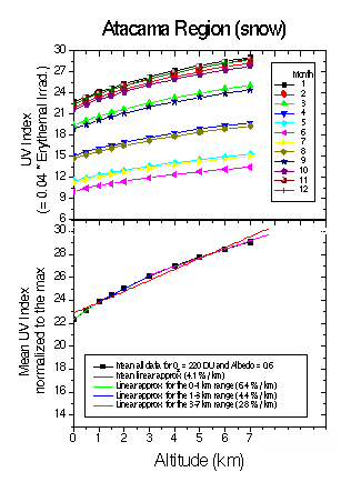
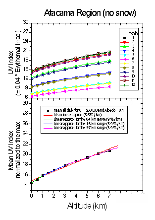
The erythemal irradiance, calculated for each month of the year as function of altitude from 0 to 7 km, a very low ozone layer (the mean minus 2 standard deviations) and for snow and no-snow conditions is displayed in figure 1. It can be seen that the UV index with ground not covered with snow, is systematically lower for each month and altitude than the UV index for snow conditions. Normalizing all curves to the absolute maximum and obtaining the mean value, it is possible to evaluate the mean slope for all altitude or for different altitudinal ranges (see also Tables 2 and 3).
|
|
|
Figure 1. Top: UV Index determined through radiative transfer model calculations for all months of the year and altitude values present in the (18º±6º) S geographical area of the Atacama region at the Andes Mountains for snow (left) and now snow (right) covered surface. This index is internationally defined as UVI=0.04*Erythemal Irradiance in mW/m2. Bottom: yearly mean UV Index increase for different altitudinal ranges, in percent per km.
Table 2. Solar risk UV index slope (in percent per km) for different
altitudes, for the Atacama Region (18º±6º) S and different months of the year corresponding to equinox
and solstice. More common situations are emphasized.
|
|
|
|
||||||
|
|
|
|
|
|
|
|
|
|
|
|
|
|
|
|
|
|
|
|
|
|
|
|
|
|
|
|
|
|
Table 3. Yearly mean of the solar risk UV index slope for different
altitudes, for the Atacama Region (18.5° S). More common situations
are emphasized.
Altitude range |
|
|
|
|
|
|
|
|
With snow |
|
|
|
A verification of the calculated values can be made comparing
these values with those measured at La Quiaca (3459 m asl), Argentina
with a YES biometer (figure 2) and at Arica (23 m asl at the Pacific
coast) and Copaquilla (3166 m asl), Chili using an IL 1400 A biometer
(see Tables 4 and 5). Kondratyev and Varotsos (2000) presented
results of erythemal irradiance measured with a UV-501 Solar Light
biometer over Athens, Greece on June 1997. Even if they were obtained
in a region of the Earth with different atmosphere and surface
albedo, the data show the same qualitative "saturation to high
altitude" behavior as the present calculations.
Table 4. Percentage variation of erythemal irradiance (directly
related with the solar risk) measured with an IL1400A instrument
at horizontal plane around solar noon in Copaquilla (18.40º S,
69.65º W, 3166 m a.s.l.) and in Arica (18.47º S, 70.31º W, 23
m. a.s.l.), Chili and comparison with the results of calculations
with radiative transfer model in "no snow" case for December month
(see figure 2). Both results are within error bands.
|
RESULT OF |
|
|
|
|
|
|
|
Table 5. UV Index (solar risk) determined at La Quiaca (22.11º
S, 65.57º W, 3459 m a.s.l.), Argentina through the measurement
of the erythemal irradiance done with a YES UVB-1 biometer of
the SCO3P (Southern Cone Ozone Project)/WMO at solar noon on February
20, 1999 compared with model result (see figure 2). Both results
are within error bands and correspond to Extreme qualification
|
RESULT OF |
|
|
|
|
|
|
|
Results for very high altitude conditions like the top of the
Parinacota volcano (Atacama desert, Andes mountains, 6342 m asl)
for all months in snow ground conditions are described in Table
6. During all months the values are in the Very High or Extreme
ranges.
Erythemal irradiances for consecutive days are given in figure
3 for normal mean ozone and low and high albedo.
Table 6. UV Index (solar risk) at the pick of Parinacota volcano
(Atacama desert, Andes mountains, 6342 m a.s.l.) for all months
in snow ground conditions. Note that during all months the values
are in the Very High or Extreme ranges.
|
|
|
|
|
|
|
|
|
|
|
|
|
|
|
|
|
|
|
|
|
|
|
|
|
|
|
|
|
|
|
|
|
|
|
|
|
|
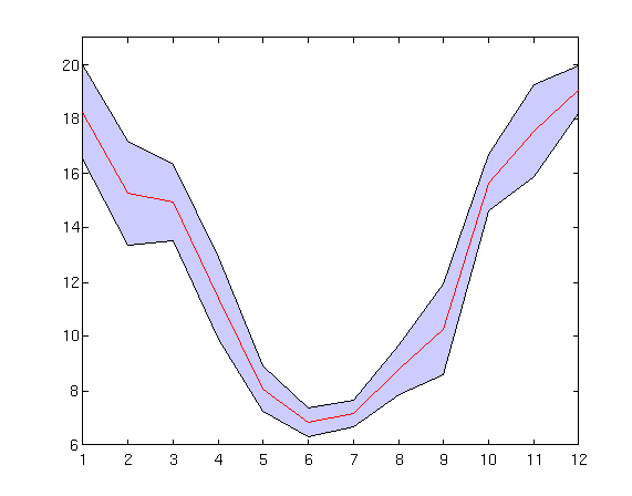
Figure 2. UV index determined from erythemal irradiance measurements done with the biometer of the SCO3P (Southern Hemisphere Ozone Project)/WMO network at La Quiaca, Argentina (3459 m asl). Mean of the last 3 years clear sky maxima plus and minus one standard deviation.
Figure 4 shows the UV index for the Southern Hemisphere solstice
and equinoxes and the day of the maximum observed irradiance at
all altitudes (January 29).
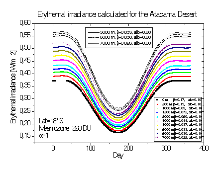
Figure 3. Erythemal irradiance calculated for the Atacama desert region for consecutive days, considering normal mean ozone (260 DU) and low (0.1) no snow and high (0.6) snow albedo, the last one at high altitudes (between 5 and 7 km).
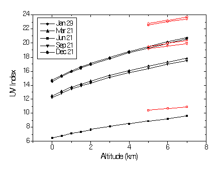
Figure 4. Solar UV index for the Atacama desert region as function of altitude, for Southern Hemisphere solar solstices and equinoxes and the day of maximum absolute UV irradiance at all altitudes (January 29). Values for mean normal ozone (260 DU) and albedo (0.1) are given as black curves and high albedo (0.6) corresponding to snow at high altitudes (5 to 7 km) are given as red curves.