1. Instituto de Física Rosario (CONICET-Universidad Nacional de
Rosario), 27 de Febrero 210bis, 2000 Rosario, Argentina. E-mail:
ruben@ifir.ifir.edu.ar
2. Facultad de Ciencias Exactas, Ingeniería y Agrimensura (Universidad
Nacional de Rosario), Pellegrini 250, 2000 Rosario, Argentina
3. Depto. Física, Facultad de Ciencias, Universidad Nacional de
San Luis, Chacabuco y Pedernera, 5700 San Luis, Argentina
4. Servicio Meteorológico Nacional, Av. de Mayo 658, 1002 Buenos
Aires, Argentina.
FIGURES
Abstract
We present new results of the intercomparison between ozone total column data registered at the Southern Hemisphere with the World Meteorological Organization ground stations of the Southern Cone Ozone Project placed in Uruguay, Argentina and the Antarctic continent, with the Total Ozone Mapping Spectrometer (TOMS) instrument on board of the Earth Probe satellite and with the Global Ozone Monitoring Experiment (GOME) instrument on board of the Earth Remote Sensing (ERS-2) satellite. At least for the region and period considered, GOME/ERS-2 ozone data gives lower mean systematic relative difference (-1.4 ± 3.2) % than TOMS/EP (4.8 ± 2.7) % with respect to ground spectroradiometers. An analysis of possible causes for the large systematic difference in this last case has been considered: differences with respect to a similar instrument placed in another satellite both measuring the same geophysical variable at different orbits; difference with respect to GOME/ERS-2 satellite measurements in all the region; possible influence on TOMS data of the difference in reflectivity at the high latitude ice (snow)-sea boundary.
Introduction
The ozone total column has been measured in the last decades employing ground based as well as satellite instruments. Comparison of the general trends of both series of data, the first one obtained by TOMS (Total Ozone Mapping Spectrometer) on board of Nimbus 7 and Meteor 3 satellites and the second one with the WMO (Dobson and Brewer) instruments from 1978 to 1994, show a mean decrease in the Southern Hemisphere (25º - 60º S) up to May 1991, before the Mount Pinatubo eruption, of -3.85 % per decade for the satellite data and almost the same, -3.87 % per decade, for the ground based one. For the ozone trends after 1991 the situation is not as clear, giving a rather mean constant behavior from TOMS measurements and a smaller decrease from ground ones (Bojkov et al., 1999).
In the last years, TOMS instruments were placed on board of two satellites, ADEOS (NASDA) and Earth Probe (or EP, NASA), orbiting at different altitudes and consequently having different pixel resolution. Also the GOME instrument on board of ERS-2 (Earth Remote Sensing, ESA) satellite is making systematic measurements of the ozone total column from 1995. In the present work we will intercompare satellite with ground based instruments data. Besides other applications, the present results can be used for analyzing in detail the Southern Hemisphere ozone trends (Bojkov et al., 1999) up to higher latitudes and the contribution of the ozone layer to the attenuation of UVB (280 - 320 nm) solar radiation (Zerefos and Bais, 1997; Herman et al, 1999; Herman et al, 2000).
Intercomparisons
In a previous study (Piacentini, 1999; Piacentini et al., 2000) we determined the relative difference between TOMS/EP and ground based instruments placed in the Southern Hemisphere, in the period 1996-1999. In the present study we extend this work, considering new results for the year 2000. Also, we incorporate data from new ground stations and from GOME/ERS-2 satellite instrument.
We first intercompare data from both TOMS placed on different satellites, EP and ADEOS. They were orbiting the Earth at different altitudes, 500 km the first and 830 km the second, simultaneously in the overlapping period of November 1996 to June 1997. The first satellite was putted in a higher orbit of 740 km, in December 14, 1997, after the ADEOS failure.
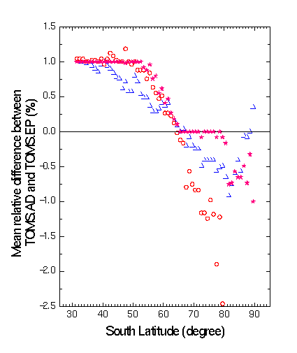
Figure 1. Percentage relative difference 200*(TOMS.AD - TOM.EP)/(TOMS.AD + TOMS.EP) of ADEOS and EP satellites total ozone data for the period where both were in orbit (Nov. 1996 - June 1997) and for the Southern Cone of South America and Antarctic region (30° - 90° S, 30° - 90° W). Longitudinal mean for all the period (solid star), for November 1996 (open triangle) and for April 1997 (open circle).
In Figure 1, we present results of this intercomparison in the region of interest, where the Southern Cone of South America and the Antarctic continent stations of the World Meteorological Organization (WMO) are placed. This constitutes the SCO3P (Southern Cone Ozone Project) of WMO and Argentina and Uruguay National Weather Stations network. It shows that the longitudinal monthly mean relative difference is within 1 %, with some variations at certain geographical locations for all the period where both satellites were in orbit and for the representative months of November 1996 and April 97. The corresponding behaviors are similar, with the exception of the rather large relative difference of around -2.5 % at a particular region near 80° W. Probably it comes from differences in the ozone column in this region during the different overpass time of both satellites or to difficulties in the satellite UV measurements at high solar zenith angles corresponding to the Sun near the horizon (Labow and McPeters, 1996). As a reference, the same intercomparison made at the Northern Hemisphere by Lloyd et al. (1999) gives a mean relative difference of about 2%.

Figure 2. Mean percentage relative difference as function of latitude for satellite (TOMS and GOME) vs. ground (Dobson , Brewer and AFO) for 1996 - 2000. The DS (Direct Sun) and ZC (Zenith Cloud) ground measurements are presented separated for comparison purposes. The stations are: Buenos Aires (34.6° S, 58.5°W), Comodoro Rivadavia (45.8° S, 67.5° W), San Julian (49.3° S, 67.5º W.), Ushuaia (54.9° S, 68.3° W), Marambio (64.2° S, 56.7° W) and Belgrano (77.9° S, 34.62° W) of Argentina and Salto (31.38° S, 57.95° W) of Uruguay. Data for the Northern Hemisphere of Lloyd et al. (1999) for the same latitudinal interval are also given (plus sign and dash-dot line).
Figure 2 shows the same mean relative difference, but now comparing the satellites TOMS/EP and GOME/ERS-2 data with those provided by the ground based Dobson, Brewer and AFO spectroradiometers of the SCO3P/WMO network. All Dobson instruments participated in the WMO Buenos Aires/Argentina calibration campaign, held last December 1999. They were within 1% with respect to the Dobson 65 Boulder International reference, except for the Marambio one, where a mirror problem was detected (R. Evans, private communication, 2000). During its calibration, it was verified that the measurements with the C (311.4 nm and 332.4 nm) and D (317.6 nm and 339.8 nm) wavelengths pairs were accurate. So, data for the years 1996 to 1999 were not included in the figure and data analysis, but those obtained in year 2000 with the C and D pairs were considered in the present work. The AFO is an automatic instrument developed by the Ozone Group of the Institute of Geophysics, San Petersburg, Rusia and measures the UV solar radiation with 5 filters up to 350 nm. It was calibrated with respect to the Boulder International reference that participated in the last WMO intercomparison, held last December 1999 at Buenos Aires as described before, giving rather good agreement, better than the 4% estimated by the builders. With respect to the previous work (Piacentini et al., 2000), new stations were included: Puerto San Julian (AFO) and Marambio Antarctic Base (Dobson) at Argentina National Weather stations. The possible influence of the Sun coveraged by clouds (Zenith Cloud data) is analyzed with respect to the uncoveraged Sun (Direct Sun data).
Data for the latitudinal range going from about 30° S to 90° S (including the Amundsen Scoot USA South Pole station) and the July 1996-December 1999 period give a mean systematic percentage relative difference between TOMS/EP and ground of (5.0 ± 2.3) % with an increase at a rate of 0.08 % per degree latitude. This mean value is a little higher than that determined for the January 2000-August 2000 period after the Dobson’s calibration was made at Buenos Aires by WMO, (4.8 ± 2.7) %, with an increase at a rate of 0.13 % per degree latitude. In particular, the USA Amundsen Scoot South Pole station (89.98º S, 24.8º W) mean difference with respect to TOMS/EP data in the period 1996-1999 was 6.4 % and for the King George Island (62.3° S, 58.9° W) Uruguay Antarctic station was 8.6 %. This last value was obtained with a Brewer automatic spectroradiometer and can be used as a verification of near stations like Marambio. It was not included in the figure, since the number of points is less than half of those of the other stations in the same period. These differences are much larger than that between both TOMS on board of different satellites (figure 1). For GOME/ERS-2, the mean value for all stations is (-1.4 ± 3.2) %.
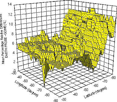
Figure 3. 3D representation of the percentage relative difference between TOMS/EP and GOME/ERS-2 for November 1999 for the Southern Cone region.
The results obtained by Lloyd et al. (1999) in a limited region of the extreme Northern part of North America (near Fairbanks, Alaska) and during the period April-September 1997, are also displayed in Figure 2 for comparison purposes. As can be seen, the mean value of the relative difference between TOMS/EP and ground spectroradiometer is (1.52 ± 0.95) %, which is lower by a factor of approximately three, in the same latitudinal domain than the corresponding relative difference analyzed in this work. In the same figure, we can see that, at least during the period of the present intercomparison, GOME/ERS-2 data shows a better agreement with ground data. Also in the same figure, TOMS/EP data were compared with GOME/ERS-2 data, giving a mean systematic difference between them in ozone total column of (5.5 ± 0.5) % in the (30° - 60° S) region, and of (7.2 ± 2.6) % in the (60° - 90° S) one, with a strong variation in the latter latitudinal range. This can be seen in more detail in the 3D representation of figure 3.
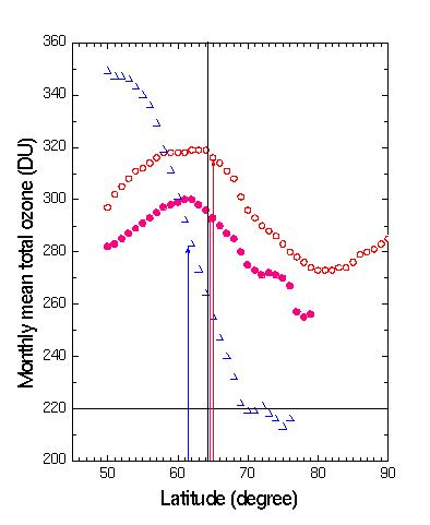
Figure 4. monthly means total ozone column values obtained by TOMS/EP as function of latitude for a longitude of 56.7º W, passing near Marambio Argentina Antarctic station for the months of January (open square), April (solid circle) and August 2000 (open triangle). The latitudes of the ice (snow)-sea boundaries are indicated as an arrow pointing the data for the corresponding month. The vertical line indicates the latitude of the Marambio station and the horizontal one gives the indication of the value 220 DU that defines the Antarctic ozone hole. Right: typical ice (snow)-sea boundary for August 2000 given by the curve around Antarctica with white and light gray colors. The line indicates the chosen meridian for analysis. Source: http://wesley.wwb.noaa.gov/ncep_data/.
Figure 4 shows the latitudinal dependence of the ozone total column, for a given longitude, that of the Marambio Argentina Antarctic Base and for different months: January and April (non ozone hole periods) and August (ozone hole one). It can be seen that the latitudinal behavior of the data is rather continuous, with no strong variation of the values at a given geographical location. The variation could be expected in the ice (snow)-sea boundary for each month of the year (see the typical case of August 2000 in Figure 3-right), if the satellite results were affected by the abrupt change in UV reflectivity when the field of observation pass from one surface of low UV reflectivity (sea and land) to the other one of high UV reflectivity (ice and snow). This result is presented for three given months, but similar data occurs for other months of the year and SH places of the world. The Antarctic ozone hole event at the analyzed meridian is evident in August 2000, when values equal to 220 DU and even lowers were registered for latitudes of about 69º and higher. So the abrupt change in the ozone values in this latitudinal domain is not related with the ice (snow)-sea possible boundary effect on satellite measurements.
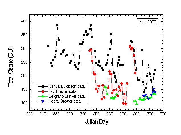
Figure 5. Total ozone data for the high SH latitude stations of Argentina and Uruguay, except Marambio, during the last 2000 Antarctic ozone hole event.
Figures 5 shows the absolute values of the ozone column for the 2000 year measured at ground at different high SH latitude stations (Ushuaia, King George Island-Uruguay, Belgrano and Sobral of Argentina). It can be seen the strong influence of the last Anctactic Ozone Hole. Also that the new Sobral data are similar to the Belgrano one, confirming these last results at very high latitudes.
Conclusions
We describe in this work the results obtained when TOMS/EP satellite ozone data are intercompared with other satellite and ground based data. The mean relative difference between both TOMS, one on board of ADEOS (NASDA) and the other one on EP (NASA) is within 1 %, for the Southern Cone of South America and Antarctic continent region (30º - 90º S, 30º - 90º W). However, the TOMS/EP-ground intercomparison shows an increase as function of latitude, with a mean systematic difference of (5 ± 2.3) % for all the region and period. The GOME/ERS-2-ground intercomparison gives a lower mean difference of (-1.4 ± 3.2) %.
Different tests have been done in order to elucidates the rather large TOMS-ground difference, like: intercomparison of two TOMS measuring at the same time and place and on board of two satellites at different orbits (and consequently different pixel resolution); comparison with other satellite instrument (GOME/ERS-2) measuring the same geophysical variable; analysis of the possible effect due to the difference in UV reflectivity at the ice (snow)-sea boundary on satellite data.
New insight appears from the present intercomparisons and future work will be done in order to try to determine the actual source (or sources) of the systematic difference between TOMS/EP and ground based spectroradiometers, which influence, besides other related subjects: The definition of the extension and depth of the Antarctic ozone hole, the model description of the UVB radiation and solar risk over the Southern Cone of South America (the most influenced large-inhabited region by the ozone depletion) and the “in situ” calibration of ground based instruments used in different institutions, with respect to the satellite one.
Acknowledgements
We like to thanks the members of the Laboratory for Atmospheres, Goddard Space Flight Center/NASA, for the fruitful discussions concerning different aspects of the present work during the visit to this laboratory and the TOMS Science Team Meetings. Also to all members of the ground based network working hardly in severe conditions mainly in Antarctica, to Dr. Marcos Machado of National Space Commission on Space Activities of Argentina and COSPAR, for his continuous support to this work and the following institutions for partial financial support: ANPCyT (Agencia Nacional de Promoción Científica y Tecnológica / National Agency for the Promotion of Scientific and Technological Research of Argentina), CONICET and National Universities of Rosario and San Luis. TOMS/NASA ozone satellite data where provided as part of the TOMS Science Team and GOME data from the corresponding Web site, with authorization. Both sources of data are kindly acknowledged. The technical computational assistance of Pablo García at the Astronomical Observatory of Rosario, Argentina, is kindly appreciated.
References
Bojkov R. D., R.D. Hudson, L. Bishop, V. Fioletov, J. M. Russell III, R. S. Stolarski, O. Uchino, C. S. Zerefos, R. Atkinson, D. S. Balis, P. K. Bhartia, H. Claude, L. Flynn, R. Guicherit, F. Hasebe, G. Labow, J. A. Logan, R. D. McPeters, A. J. Miller, R. Müller, R. D. Piacentini, W. J. Randel, H. Smit, B. H. Subbaraya, K. Tourpali, P. Von der Gathen, A. Zand, Ozone Variability and Trends in Scientific Assessment of Ozone Depletion:1998, Chapter 4, WMO Report 44, Geneva, 1999.
Herman J. R., R. L. McKenzie, S. B. Diaz, J. B. Kerr, S. Madronich, G. Seckmeyer, G. Bernhard, M. Blumthaler, B. Bodhaine, C. R. Booth, E. Celarier, P. Forster, N. Krotkov, J. Lenoble, K. Leszczynski, C. S. Long, B. Mayer, F. Mims, P. Neale, R.D. Piacentini, K. Ryan, H. Slaper, J. Slusser, R. Wooldridge, C. S. Zerefos, Ultraviolet Radiation at the Earth's surface in Scientific Assessment of Ozone Depletion:1998, Chapter 9, WMO Report 44, Geneva, 1999.
Herman J., R. D. Piacentini, J. Ziemke, E. Celarier and D. Larko, Interannual Variability of Ultraviolet Exposure in the UVB Range, J. of Geophysical Research, in press, 2000.
McPeters R. D. and G. J. Labow, An Assessment of the Accuracy of 14.5 Years of Nimbus 7 TOMS Version 7 Ozone Data by Comparison with the Dobson Network, Geophys. Res. Lett., 3695-98, 1996.
Lloyd S., W. H. Swartz, T. Kusterer, D. Anderson, C. T. McElroy, C. Midwinter, R. Hall, K. Nassim, D. Jaffe, W. Simpson, J. Kelley, D. Nicks, D. Griffin, B. Johnson, R. Evans, D. Quincy, S. Oltmans, P. Newman, R. McPeters, G. Labow, L. Moy, C. Seftor, G. Toon, B. Sen and J. F. Blavier, Intercomparison of Total Ozone Observations at Fairbanks, Alaska, During POLARIS, J. Geophysical Research, 104, D21, 26767-26778,1999.
Piacentini, R D., Ozone and UV Reseach in Argentina", Invited lecture at the 1999 TOMS Science Team Meeting, Goddard Space Flitght Center/NASA, Lauder, Maryland, USA, 1999.
Piacentini R D, E. Crino, J. Sirur Flores and M. Ginzburg, Intercomparison Between Ground Based and TOMS/EP Satellite Southern Hemisphere Ozone Data. Submitted for publication, 2000.
Zerefos C and A. Bais. Solar Ultraviolet Radiation. Springer, Berlin, 1997.
Back to
| Session 1 : Stratospheric Processes and their Role in Climate | Session 2 : Stratospheric Indicators of Climate Change |
| Session 3 : Modelling and Diagnosis of Stratospheric Effects on Climate | Session 4 : UV Observations and Modelling |
| AuthorData | |
| Home Page | |