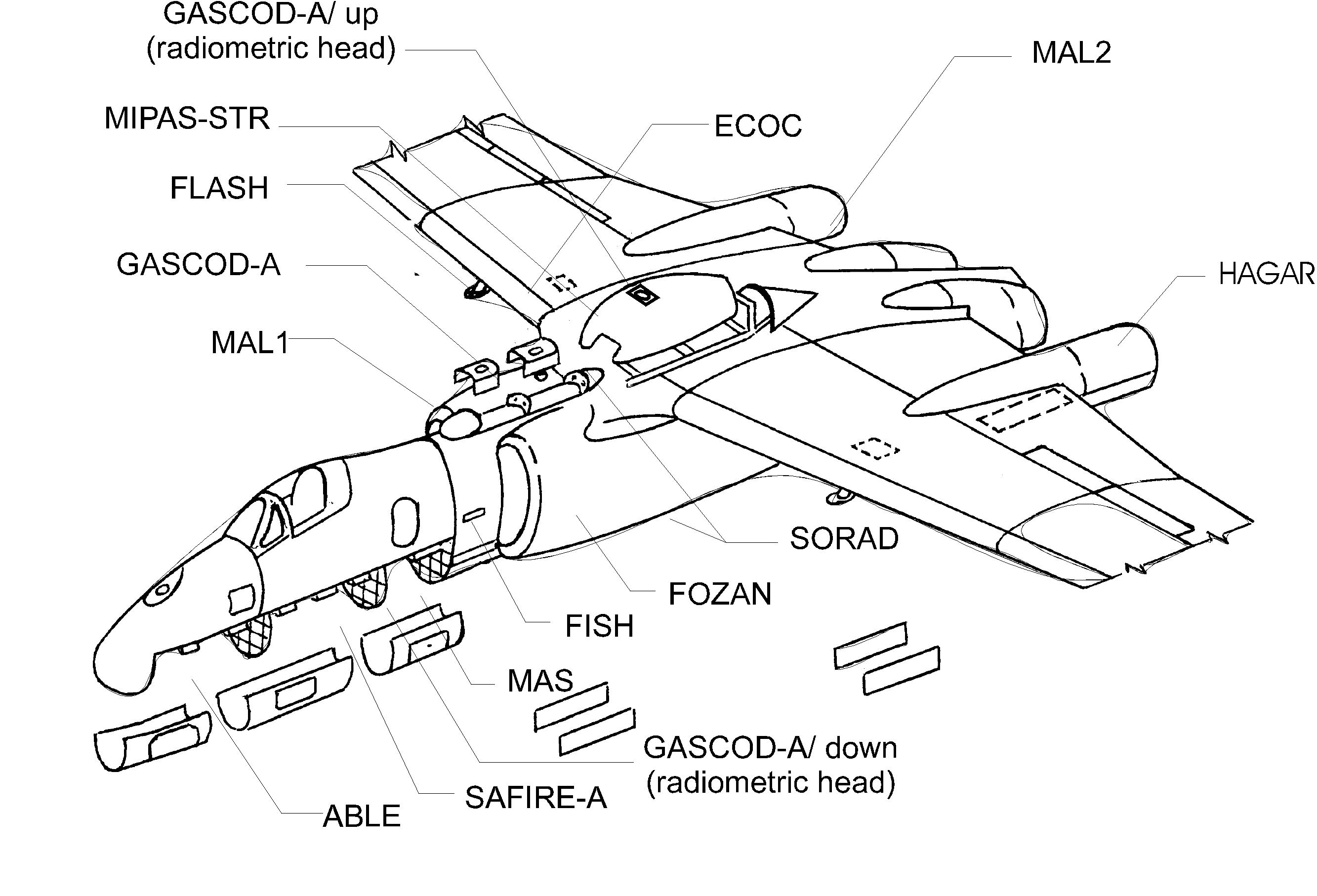
Figure 1 : Location of the APE-GAIA scientific instruments on board the Geophysica aircraft
(1) IROE-CNR, Firenze, Italy
(2) IMK-FZK, Karlsruhe, Germany
(3) Università dell’Aquila, L’Aquila, Italy
(4) University of Leeds, Leeds, UK
FIGURES
Abstract
A research campaign of the M55-Geophysica high-altitude aircraft has been carried out from the base of Ushuaia (Argentina; lat 54°S; long. 68°W) in the period 15th September - 15th October 1999, to study the chemical and dynamical mechanisms involved in stratospheric ozone destruction between the end of the ozone depletion and the beginning of the recovery phase (APE-GAIA campaign, Airborne Polar Experiment - Geophysica Aircraft In Antarctica). The aircraft, equipped with remote-sensing and in-situ instruments for observation of atmospheric chemistry and microphysics, performed five scientific flights over the Antarctic Peninsula investigating the mixing between mid-latitude and polar air masses, as well as specific events such as the formation of lee-waves induced PSC and extrusions of filaments out of the polar vortex. A general overview of the APE-GAIA campaign is reported and the main operative and scientific results obtained during the mission are discussed.
1. Introduction
In the frame of the APE project (Airborne Polar Experiment), promoted by the Italian National programme for Antarctic Research (PNRA) in co-operation with the Russian Myasishchev Design Bureau (MDB), Aviaecocentre (AEC) and Central Aerological Observatory (CAO), a new high altitude research platform, the Russian aircraft M55-Geophysica has been recently made available for atmospheric studies. The APE program aimed at gathering new experimental data on the polar upper troposphere and lowermost stratosphere, to gain a deeper insight of the mechanisms responsible for stratospheric ozone depletion. The M55 aircraft was modified to accommodate several scientific instruments performing in-situ and remote-sensing measurements of the microphysical and chemical structure of the polar atmosphere [Stefanutti et al., 1999, I]. The capabilities of the aircraft and of its scientific payload have been first demonstrated during a field campaign conducted in the Arctic region, from the base of Rovaniemi, Finland (lat. 66° 34’ N, long. 25° 48’ E) in the Winter 1996/97 [APE-POLECAT campaign Stefanutti et al., 1999, II] and have been fully exploited during the APE-GAIA campaign (Geophysica Aircraft In Antarctica) carried out from the southernmost tip of South America to study the microphysics and chemistry of the Antarctic stratosphere.
This paper summarises the main scientific issues addressed by the APE-GAIA mission, providing a short description of the research platform of the payload; as well as of the modelling tools used for the scientific flight planning. Some detail is given about the five scientific flights performed by the Geophysica aircraft over the Antarctic peninsula and first results obtained from post flight data analysis and interpretation are discussed.
2. The scientific objectives
The APE-GAIA campaign aimed at studying several key scientific issues related to chemistry and transport at the boundary of the southern polar vortex (Carli and Blom, 1997). The campaign took place from the operative base of Ushuaia, Argentina (lat 55° S, long 68° W) in the period from 15th September to 15th October 1999, thus allowing observations at the transition between the end of stratospheric ozone depletion and the beginning of the recovery phase of chlorine reservoir species. Flying southward, over the Antarctic Peninsula, up to the limit of its operative range (approximately 70° S) and at altitudes between 14 and 20 km (with occasional "dives" down to 10 km), the M55-Geophysica was able to reach the edge of the vortex and to penetrate inside the chemically perturbed region. The aircraft performed five scientific flights (for a total of 30 flight hours), during which the main targets of the mission were investigated using both remote-sensing and in-situ techniques.
In a detailed planning of the scientific objectives to be pursued during the Antarctic mission (Redaelli and Chipperfield, 1999), the following priorities were identified:
Most of these goals were achieved, taking advantage of the profiling capabilities of the remote-sensing instruments, as well as of the information on chemical composition and physical properties of the air masses observed, respectively, by the in-situ chemistry package and by the microphysics payload.
3. The high altitude platform and the APE-GAIA payload
The complete set of instrument which operated in the frame of the APE-GAIA campaign is listed in Table 1, along with some general information about the techniques and the products of the measurements. The location of the instruments onboard the M55 Geophysica aircraft is shown in Figure 1. The payload includes remote sensing and in-situ equipment for gaseous trace compounds, instruments aimed at characterising aerosols and cloud particles and devices for radiation measurements. From the point of view of the scientific objectives and of the measurement technique, the payload can be divided into remote sensing instruments for the measurement of the chemical composition of the atmosphere (remote sensing chemistry payload), in-situ instruments for the measurement of the chemical composition of the atmosphere (in-situ chemistry payload), and instruments for the study of the aerosols (microphysics payload)
.
Figure 1 : Location of the APE-GAIA scientific instruments on board the Geophysica aircraft
The remote sensing chemistry instruments are the core of this payload as they provide simultaneous measurements of a large suite of chemical species. The two Fourier Transform Spectrometers MIPAS-STR and SAFIRE-A make limb and upward soundings to obtain column amounts above the aircraft and profiles below. Together they cover the main components of the Cly family (ClO, HCl and ClONO2), MIPAS-STR almost covers the entire the NOy family, whereas SAFIRE-A obtains information on Bry. GASCOD-A uses the DOAS technique and measures total amounts of the trace constituents at zenith and nadir in the case of high sun, and vertical profiles in the case of sunrise and sunset. Important active species observed by this instrument are OClO and BrO. The three instruments also observe several long-lived source gases. Their redundant measurements allow validation of the individual measurements and thus an improvement of the quality and reliability of the APE-GAIA data. In situ instruments provide measurements of ozone, water vapour and long-lived tracers at flight altitude with high spatial resolution. From these measurements vertical distributions can be observed during dives of the aircraft. The horizontal variability of the atmospheric composition and the dynamics of the mixing can be derived during flights at constant altitude ensuring an important synergy with the more extended vertical maps that the remote observations obtain on the basis of the assumption of horizontal homogeneity. Aerosols and PSC particles are detected and characterised by lidars and scatterometers pointing at different directions and operating with different ranges and different longitudinal resolutions. Correlation of PSC detection with the measurements of atmospheric composition simultaneously made by the "chemistry payload" provides an opportunity for the direct analysis of the effects of PSC formation (denitrification, dehydration, heterogeneous chemistry). Finally, two instruments provide measurements of radiation fluxes for a more precise quantification of photochemical parameters.
|
|
|
|
|
|
|
|
Remote-sensing Chemistry and Radiation |
GASCOD-A Gas Absorption Spectrometer Correlating Optical Differences ? Airborne |
|
Vertical profiles and column of O3, NO2, OClO, BrO. Actinic flux measurements |
ISAO-CNR Bologna, Italy |
|
|
MIPAS-STR Michelson Interferometer for Passive Atmospheric Sounding ? STRatospheric |
|
|
IMK-FZK Karlsruhe, Germany |
||
|
SAFIRE-A Spectoscopy of the Atmosphere using Far-InfaRed Emission-Airborne |
|
|
IROE-CNR Firenze, Italy |
||
|
SORAD SOlar RADiation |
|
|
CAO Moscow, Russia |
||
|
|
ECOC ElectroChemical Ozone Cell |
|
|
CAO Moscow, Russia |
|
|
FOZAN Fast OZone Analyzer |
|
|
CAO Moscow, Russia |
||
|
FISH Fast In-situ Stratospheric Hygrometer |
|
|
ICG-FZJ Juelich, Germany |
||
|
FLASH FLuorescence Airborne Stratospheric Hygrometer |
|
|
CAO Moscow, Russia |
||
|
HAGAR High Altitude Gas AnalyzeR |
|
N2O, SF6, CO2, CFC-12, CFC-11, Halon-1211 |
IMG, Univ. of Frankfurt Frankfurt, Germany |
||
|
|
ABLE AirBorne Lidar Experiment |
|
Particle density and optical properties from 2 to 15 km from the aircraft |
Univ. of Rome Rome, Italy |
|
|
MAL-1 Microjoule Airborne Lidar |
|
Particle density up to 10 km above the aircraft |
Observatory of Neuchatel Neuchatel, Switzerland |
||
|
MAL-2 Microjoule Airborne Lidar |
|
Particle density up to 10 km below the aircraft |
Observatory of Neuchatel Neuchatel, Switzerland |
||
|
MAS Multiwavelength Aerosol Scatterometer |
|
Particle density up to 2 km from the aircraft |
IFA-CNR Roma, Italy |
Table 1: The APE-GAIA scientific instruments
4. The Antarctic flights
The scientific planning of the flights was first focused on the scientific objectives of the campaign listed in paragraph 2. Individual flight plans were then finalised in the field using detailed forecasts. These forecasts includes standard output from global numerical weather prediction models, as well as high resolution trajectory/contour advection models (to identify filaments), lee wave models (to identify mountain wave PSCs), 'both provided by the University of L'Aquila (Italy), and global chemistry transport models provided by the University of Leeds (UK). A map of the five scientific flights performed by the M55 aircraft over the Antarctic peninsula is shown in Fig. 2. Further details about the flight profiles are given in Table 2, where the specific objective of the flight is indicated along with the conditions or events that triggered the final choice of the route and of the timing.
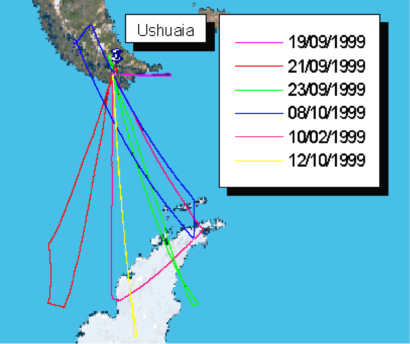
Figure 2 : Map of the five scientific flights performed by the M-55 Geaophysica from the base of Ushuaia (Argentina) during the APE-GAIA mission
|
|
|
|
|
|
990921 (daytime) |
SW ? Multi legs ? 2 altitude levels + dive (1st leg over 380 K isentropic surface) |
|
Position of vortex edge: isentropic PV forecast maps |
|
990923 (daytime) |
SE ? 2 legs ? 2 altitude levels + dive (1st leg over 420 K isentropic surface) |
Across vortex edge Chemistry of polar air |
Position of vortex edge: isentropic PV forecast maps |
|
991002 (nighttime) |
S-NE-NW ? Triangle + dive (1st leg over 400 K isentropic surface) |
Lee-waves induced PSCs over the Antarctic peninsula |
Lee waves alert: MM5 mesoscale fields |
|
991008 (nighttime) |
SE ? 4 legs ? 2 isentropic + dive (1st leg over 380 K isentropic surface (2nd leg over 420 K isentropic surface) |
|
Forecast of filament: Hi. Res. DFT PV maps |
|
991012 (daytime) |
S ? 2 legs ? 2 altitude levels + dive (1st leg over 410 K isentropic surface) |
Across vortex edge Chemistry of polar air |
Position of vortex edge: isentropic PV forecast maps |
Table 2 : Details about flight profiles and scientific objectives of the Antarctic flights
False colour images of the isentropic Potential Vorticity (PV) over the 400 K isentropic level (approximately 16 km) for the days of the APE-GAIA flights (at 12.00 GMT) are reported in Fig. 3, to locate the position of the vortex during the campaign period..
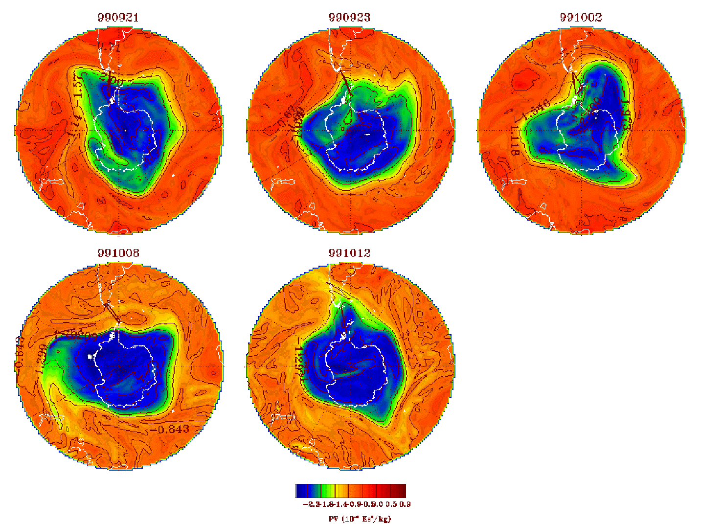
Figura 3 : Potential Vorticity maps over 400 K isentropic surface
4-1 Flight across the polar vortex boundary
The objective of the first flight (990921) was to obtain measurements throughout the tracer gradient which defines the boundary of the vortex, and to travel as deep as possible inside the vortex. This was also the task of the second flight (990923) which provided a further sampling of the polar vortex at slightly higher altitudes, as well as daytime observations of photo-chemistry activation inside the vortex, and of the last flight performed at a later time (991012): in this way, information on the chemistry of the polar lower stratosphere and the mixing between polar vortex and mid-latitude air was obtained both at the beginning of the campaign, during on-going ozone depletion, and at its end during the recovery phase.
An example of observations made by the in-situ instruments during the flight of 23rd September 1999 is shown in fig.4. Most species were observed by a single instrument, but in the case of ozone (bottom plot) two independent measurements are superimposed and show very good agreement. Ozone, water vapour and most tracers have very similar variations both in the general shape of the curves as well in some of the small features. The event of a rapid drop of concentrations synchronously observed for most species can be considered to identify the crossing of the vortex edge. Along with in-situ measurements, in the same flight, the limb sounding observations performed by MIPAS-STR and SAFIRE-A allowed to determine the 2-D distributions of different stratospheric compounds with a horizontal resolution of around 40 km (MIPAS-STR) and 100 km (SAFIRE-A) and with a vertical resolution of 2-3 km below the aircraft and column amounts above. As an example, colour contour plots of Ozone and ClO, as measured by SAFIRE-A during the 990923 flight is shown in Fig. 5, showing the enhancement of chlorine monoxide in daytime conditions inside the polar vortex and a clear anti-correlation with ozone mixing ratio values.
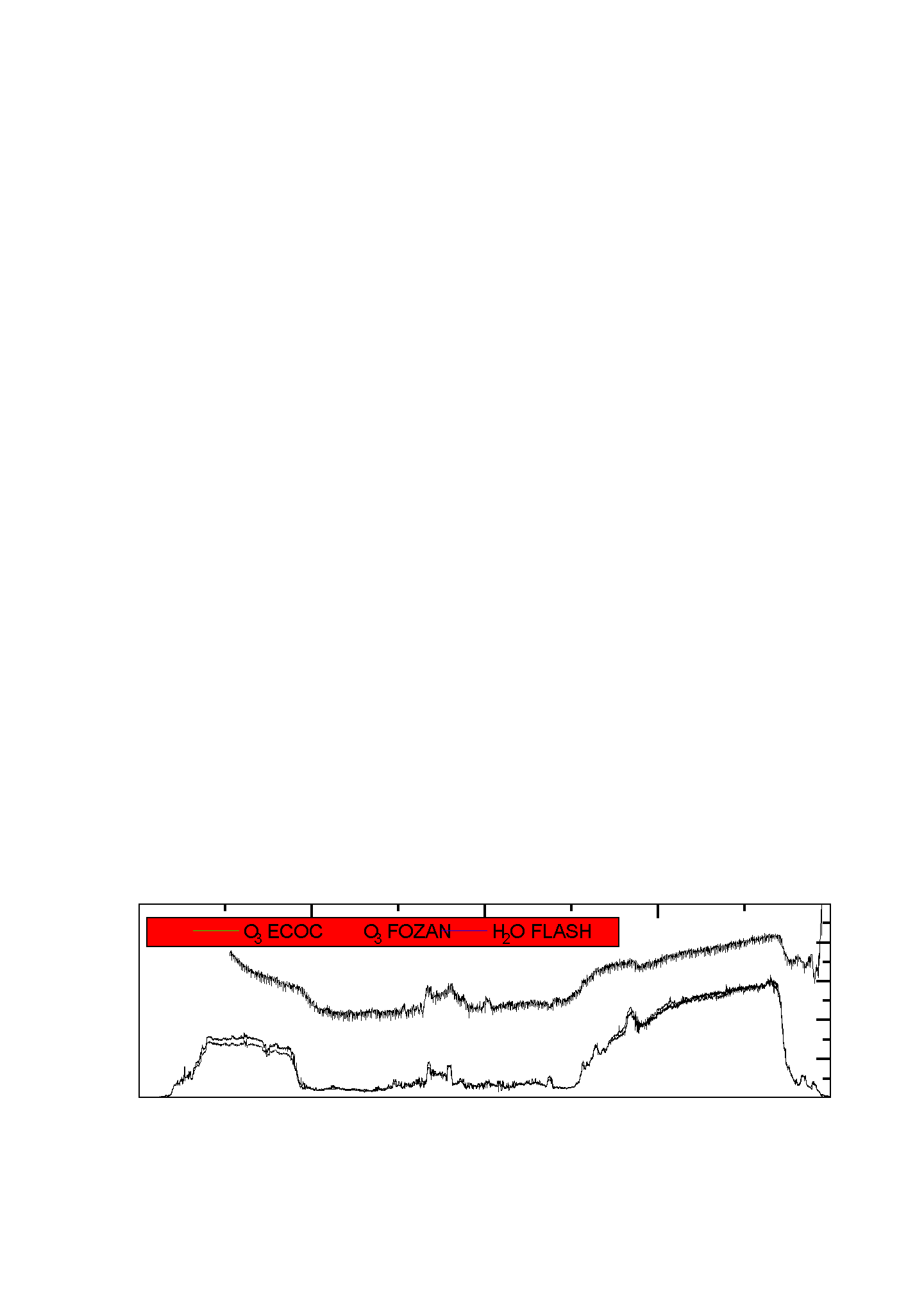
Figure 4: Altitude, latitude and in-situ measurements of minor constituents acquired during the flight of 23rd September 1999
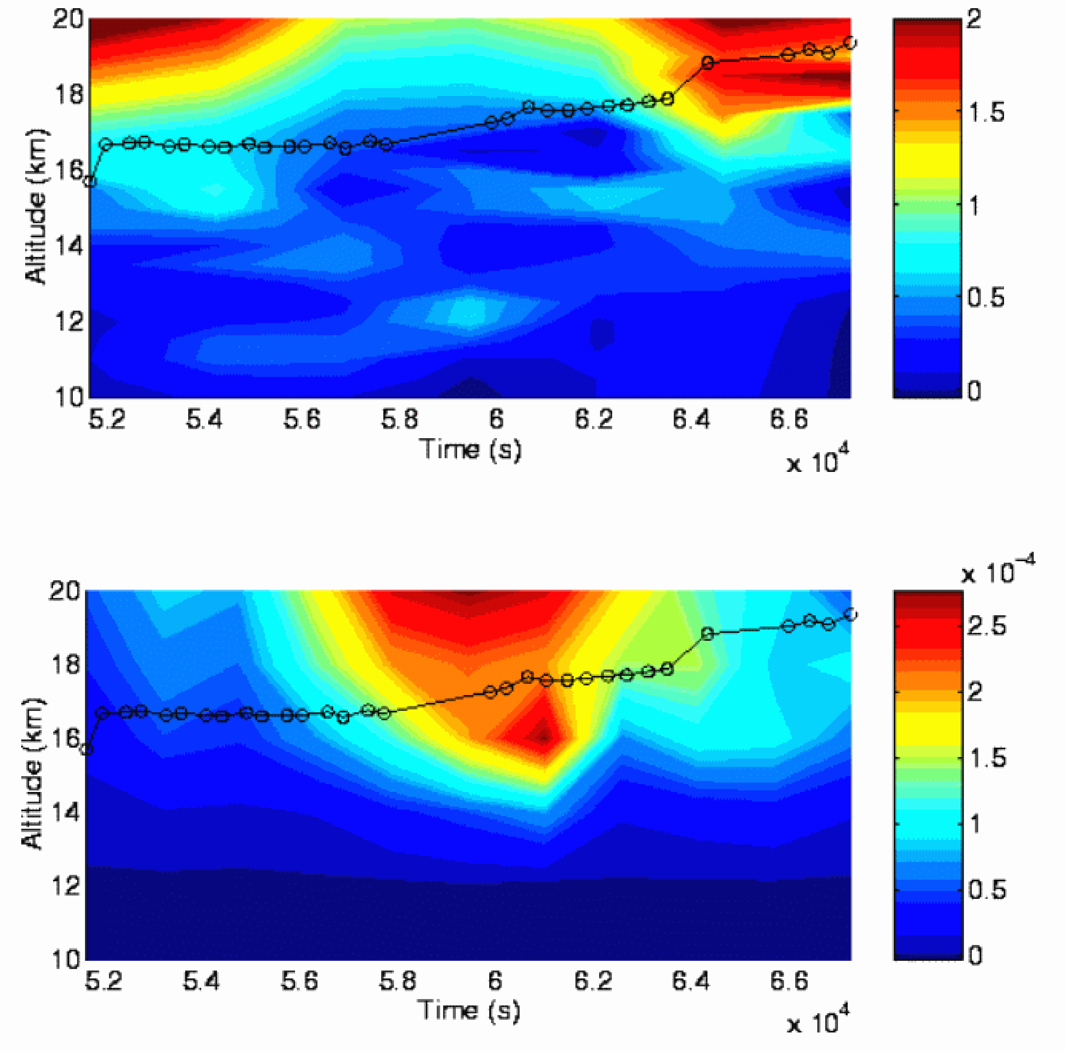
Figura 5: 2D distributions of Ozone (upper panel) and ClO (lower panel) volume mixing ratio (in ppmv) measured by SAFIRE-A as a funtion of altitude and time (UTC) during the 990923 flight.
4.2 Detection of a large PSC event
On the 2nd of October the M55-Geophysica flew from Ushuaia toward the Palmer peninsula, following a three legs trajectory, with the second leg along the eastward branch of the peninsula, where MM5 PSU/NCAR mesoscale model forecast predicted lee-wave formation.
The temperature experienced on the second leg of the flight, with the aircraft cruising at altitude of 18-19 km for about 800 km, was below Tice. Both data recorded by the MAS laser backscattersonde and by the MAL microjoule lidar show clear evidence of a large PSC event in this region. The vertical structure of the cloud was recorded by the zenith channel of MAL. Two towering clouds can be discerned in fig.6, showing respectively the backscatter ratio and depolarisation ratio observed by the lidar, versus time. The min. and max. values in the temperature fields from the mesoscale MM5 run seems to be well anti-correlated with min. and max. of the backscatter values. The backscatter vs depolarisation scatterplot (fig. 7) is consistent with the hypothesis of a type II PSC.
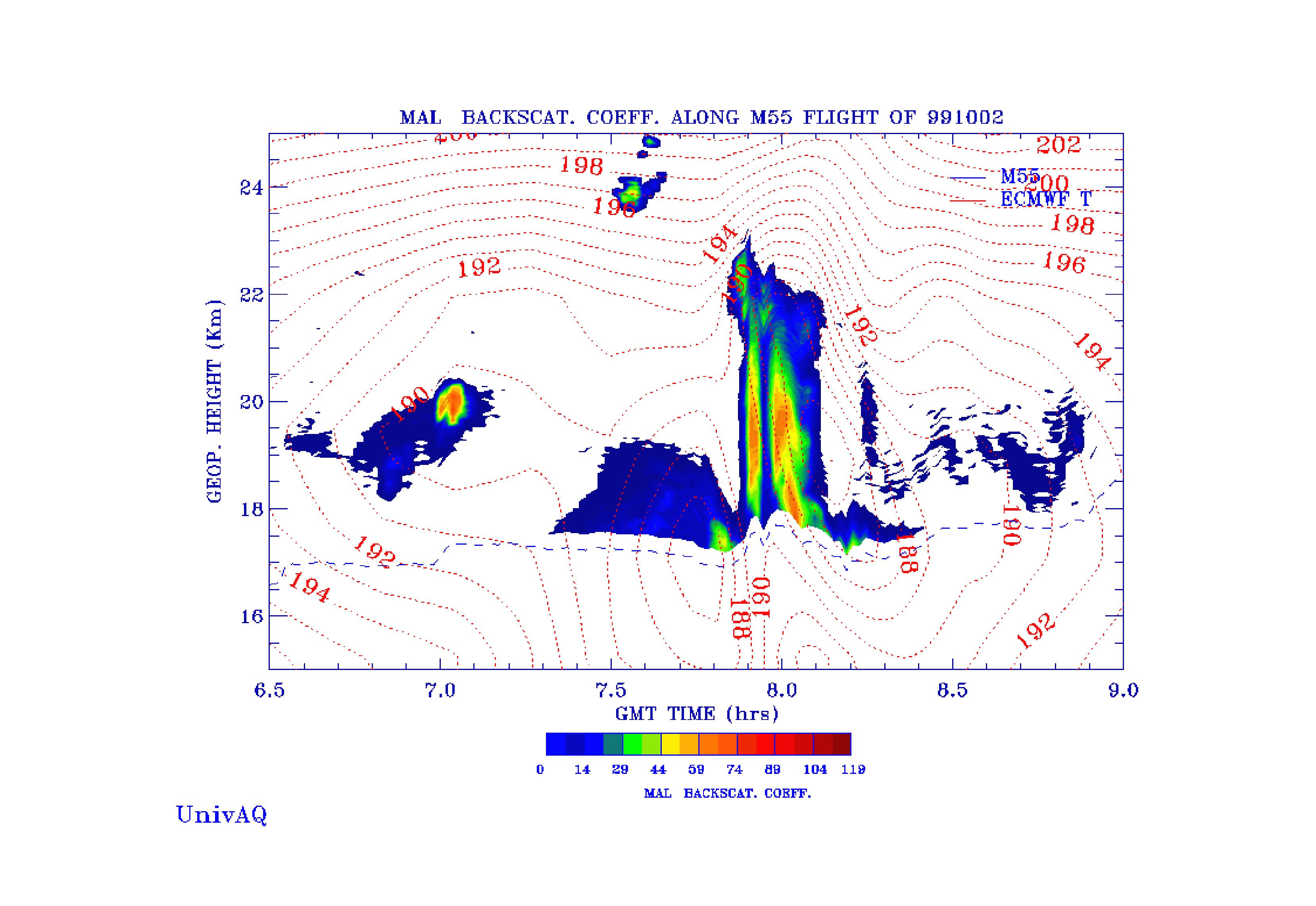
Figure 6: Profiles of backscatter ratio observed by the microjoule lidar MAL above the flight level, superimposed to the temperature fields from global ECMWF analysis
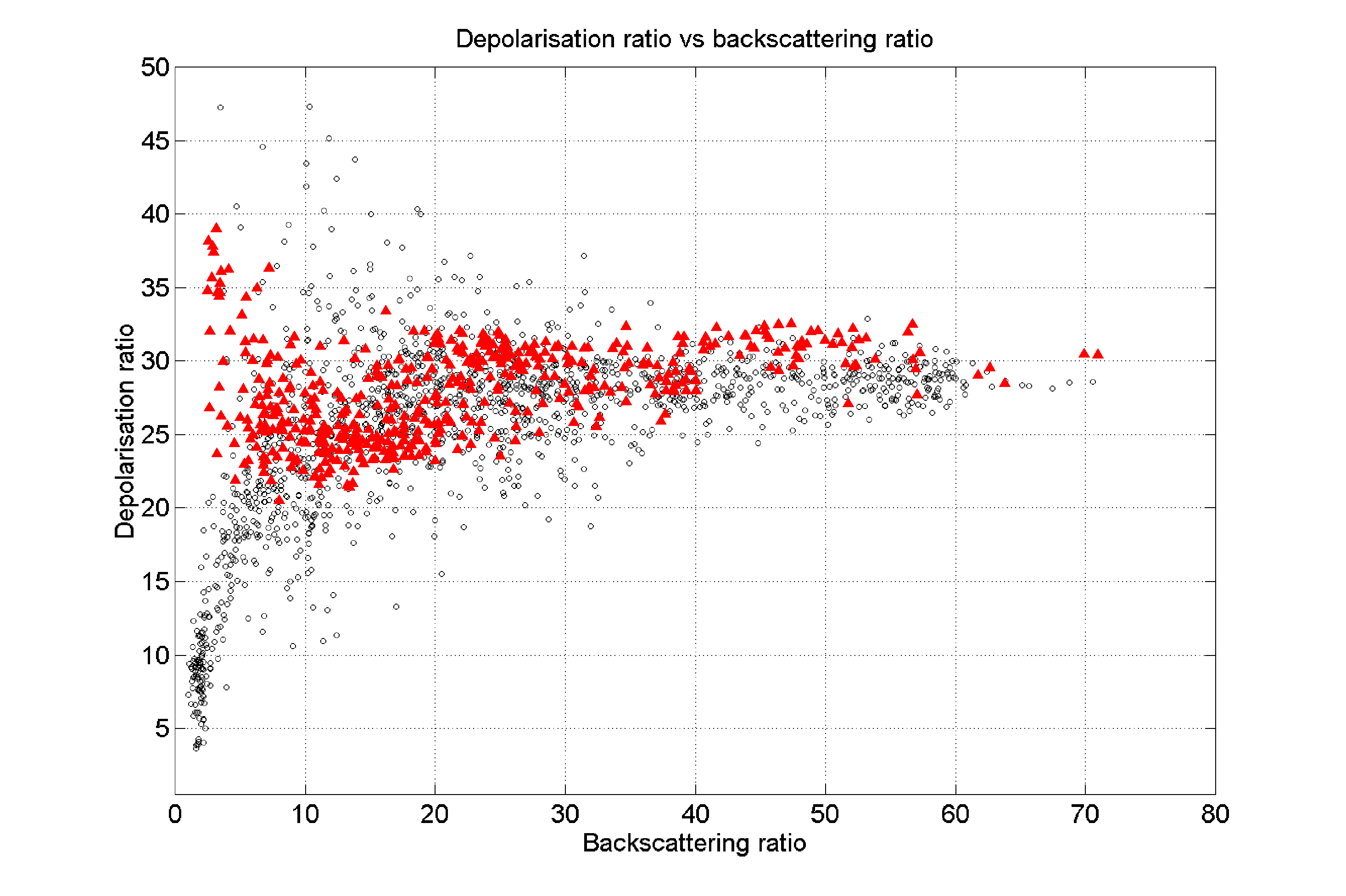
Figure 7: Scatterplot of backscatter versus depolarisation ratio, showing both MAS (red triangles) and MAL (circles) datasets
4.3 Flight across a filament
The fourth scientific flight aimed at studying the physical and chemical conditions within and without a filament predicted from high resolution PV fields for the 8th of October 1999 between Tierra del Fuego and the Antarctic Peninsula at an altitude between 14 and 18 km.. Signature of the filament was already clearly present in the PV forecasted products since 96 hours in advance. To verify and study the occurrence of this structure a flight was planned, with a four legs track over two isentropic surfaces: 390K and 450K.
As forecasted, while flying quasi isentropically at 450 K, both in-situ and remote-sensing instruments detected an intense and localised variation of the measured tracers, that is supposedly related with the sampling of the vortex filament structures along the flight track. Also, high resolution PV products (not shown here) picture a three-dimensional filament with a strong horizontal gradient, a deep vertical shape and a high resolution internal structure that seems to fairly match with the preliminary analysis of the time series of experimental data. Further analyses, involving the complete set of tracers data available from onboard instrumentation, is needed to have a more complete understanding of this case.
5. Auxiliary Measurements
In parallel with the Geophysica flights, ground-based and balloon measurement were made in parallel with the Geophysica flights from different sites in Tierra del Fuego and on the Antarctic Peninsula. Ground-based ozone, NO2, SO2 and UV radiation measurements were carried out from Ushuaia. On the Antarctic Peninsula, real-time measurements of total ozone and NO2 were obtained from the base of the British Antarctic Survey in Rothera (67° 34’ S; Long. 68° 07’ W), along with radiosonde launches. ozone soundings, temperature, humidity and wind radiosondes. Total column ozone values were obtained from the Argentinean bases of Marambio (64°23' S, 56°72' W) and of Belgrano II (Lat. 77º 52' S; Long. 34º 37' W), the activity in the former base being performed in collaboration with the Finnish Meteorological Institute. From these two bases ozone and NO2 measurements were also obtained by the INTA (Spain) and CNR-IFA (Italy).
A preliminary comparison of the ozone measurements made from Marambio and those made from the limb sounding instruments on-board the aircraft during the flight of 23rd September 1999 is shown in Fig. 8. The plot shows the ozone mixing ratio vertical profile measured by the ozone sonde and the averaged profiles obtained from four sequences recorded by MIPAS-STR and SAFIRE-A over Marambio. The comparison is possible up to the aircraft altitude (approximately 18 km), above which MIPAS-STR and SAFIRE-A simply scale the initial profiles from a column measurement.
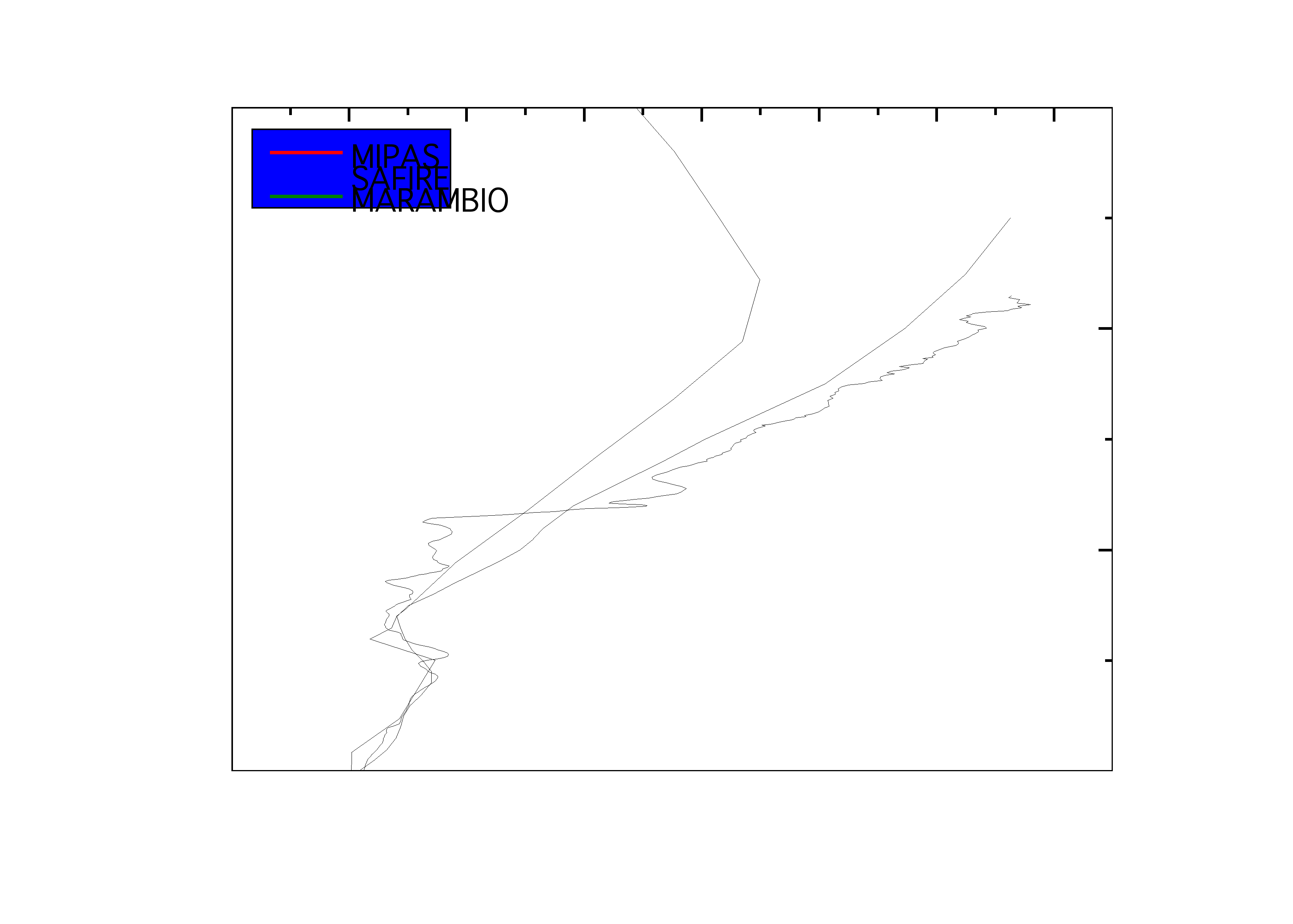
Figure 8: Comparison of O3 measurements of MIPAS-STR and SAFIRE-A with the ozone sounding
6. Conclusions
During the APE-GAIA campaign a comprehensive payload of scientific instruments has been successfully flown aboard the M55-Geophysica aircraft and collected high quality data on the chemical and physical structure of the lower stratosphere across the edge of the southern polar vortex. Reliable operation of both the research platform and the scientific instruments, along with accurate forecasts provided by atmospheric models and auxiliary measurements carried out form ground stations and balloons allowed to cover all the scientific priorities identified in the scientific planning of the mission.
7. References
L. Stefanutti et al. "APE-POLECAT-Rationale, Road Map and Summary of Early Results", Journal of Geophysical Research, Vol 104 No. D19 Pages 23941-23959, ottobre 1999.
L. Stefanutti et al., "The M-55 Geophysica as a Platform for the Airborne Polar Experiment", Journal of Atmospheric and Oceanic Technology, Vol. 16 Pages 1303-1312, ottobre 1999.
B. Carli and C.E. Blom, "Scientific Objectives for the APE Chemistry Mission to Antarctica", 10 settembre 1999, Com. Priv. .
M. Chipperfield, G. Redaelli, "Science Issues and Teorethical/Modelling Work for APE-GAIA", 10 settembre1999, Com. Priv.
Back to
| Session 1 : Stratospheric Processes and their Role in Climate | Session 2 : Stratospheric Indicators of Climate Change |
| Session 3 : Modelling and Diagnosis of Stratospheric Effects on Climate | Session 4 : UV Observations and Modelling |
| AuthorData | |
| Home Page | |