Previous: Diagnostic Tools Next:References Up: Ext. Abst.
Results and Remarks
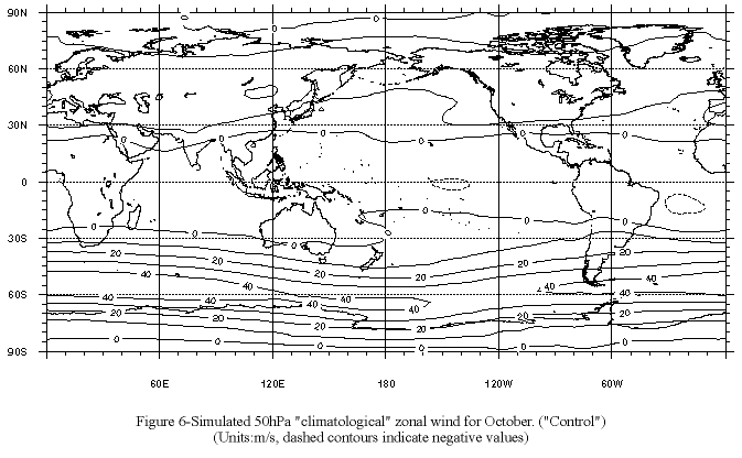
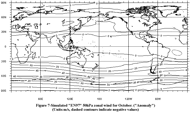
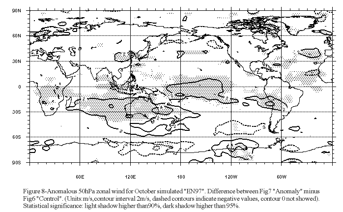
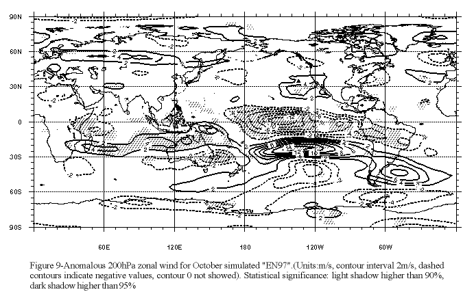
Comparison of the simulated climatological October ("Control") and EN97 October ("Anomaly") 50 hPa zonal wind (Figs. 6 and 7) to the corresponding "observed" fields (Figs. 1 and 2) show that the model is capable of simulate the most important features of the October climatology as well as those associated to an EN (warm) event. This fact can be seen much better by looking at the field of differences ("An"-"Cr") between the two ensembles of the 50 hPa zonal wind (Fig. 8) which shows a clean agreement with observed features (Fig. 3), with increased westerlies in the southern part of the vortex and decreased westerlies in the northern part between 140ºW and 80ºW. This anomaly has an area with t-Student statistical significance higher than 95% (Canavos 1988) in the region of zonal wind positive anomalies (shadow areas show statistical significance, Fig. 8). This anomaly can also be observed at high latitudes at 200hPa in the zonal wind difference between ensembles (Fig. 9), and it is a manifestation of the barotropic characteristics of the atmosphere there, typical of large scale patterns. The reversed sign anomalies of the 50 hPa zonal wind present to the southeast of South America in the "observed" field (Fig. 3) are also present in the simulated one (Fig. 8) although statistical significance is not so clear than for the former feature present to the southwest of South America
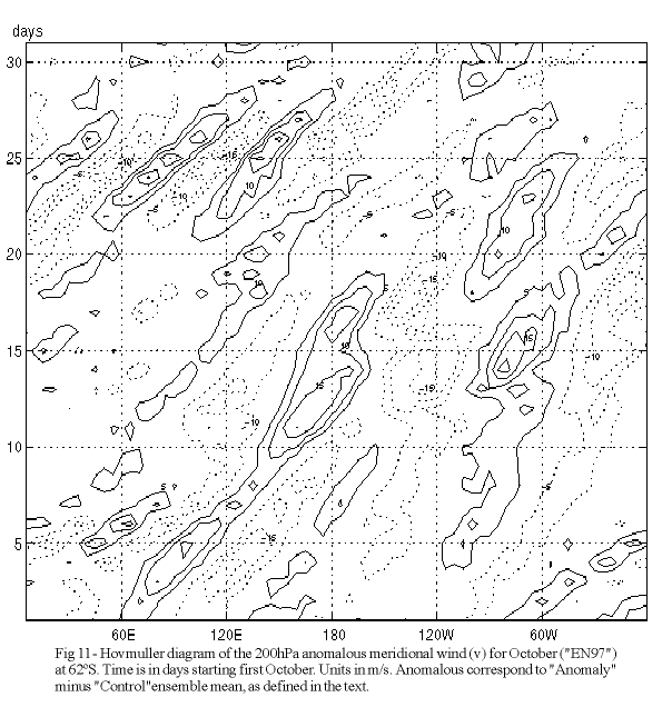
These features are shown also by using Hovmuller (longitude-time, October simulated) diagrams of the anomalous meridional wind at two different levels and for the difference between ensembles. The analysis are made at 62ºS, and at 200 and 50 hPa. Hovmuller diagram at 200 hPa (Fig 11) shows a quasi-stationary disturbance corresponding to a wave number 3 between 0-180W, which lasts more than ten days installed in the general eastward zonally propagating wave field. There are also shorter propagating waves (number 6) in the last days of the month, between 0-180E.
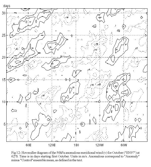
In the diagram at 50 hPa (Fig 12) it can be noted, also, the wave number 3, very similar to the one noted at the 200 hPa diagram, which reflects the main observed circulation anomaly at this height. The simulation shows a quasi-equivalent barotropic vertical structure of the atmospheric circulation, at less for the wave number 3 type of features, at that region, associated to the (large scale and) strongly anomalous boundary conditions imposed. This could be interpreted as a direct influence of the upper troposphere in the lower stratosphere through changes in the tropopause height. In the 50 hPa diagram, there are also some waves associated with the shorter waves seen at 200 hPa diagram (but of larger zonal scale and of no barotropic equivalence), which are coherent with the vertical propagation characteristics of the tropospheric shorter waves (mainly 4-7) which are not able to propagate into the stratosphere (Randel and Held 1991).
The simulation shows a quasi-equivalent barotropic vertical structure, which is consistent at 200mb with the PSA pattern, a Rossby-wave type structure, and at 50hPa with the observed pattern for EN composite.
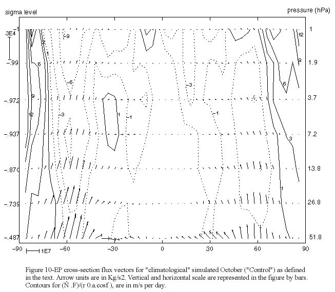
Additional analysis of the wave activity propagation is obtained from the study of the simulated averaged EP vectors (Fig 10) for the "Control" ensemble which shows the upward propagation of waves and the generation of smaller scale waves by nonlinear and mixing processes.
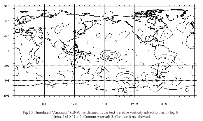
To characterize the observed pattern at s =.245 (almost coincident to ~=200hPa) as a Rossby wave structure, we also have used a vorticity analysis. By doing so it can be seen that there is a cancellation between the first three terms of the vorticity equation (Eq 1): the term representing the advection of relative vorticity (Fig. 13), which cancels the addition of the terms of advection of planetary vorticity and vorticity induction through divergence (Fig. 14). The addition of these terms is one order of magnitude smaller than them in all those areas that show important values in Figs 13 and 14, which is typical of a Rossby wave.
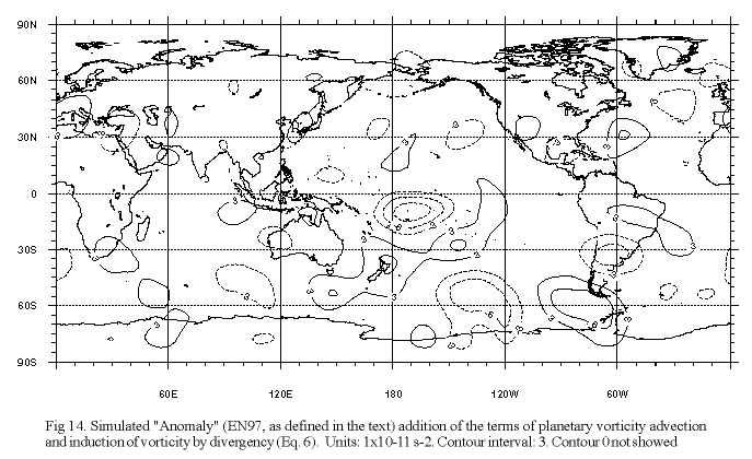
We can conclude that the most relevant physical mechanisms associated to the circulation anomaly reproduced by the model are the advection of planetary vorticity, the advection of the relative vorticity and the divergence-induced vorticity, other than the transient effects and the non-linear interactions. (However, we should notice that the model operating at this resolution tends to underestimate the transient activity). As the model reproduce the most relevant features of the 50 hPa anomalies associated to the EN97 warm event (i.e. the "shift" of the vortex to higher latitudes in the Pacific sector), it may be said that the intramonthly transients are not very important in the establishment of the lower stratospheric anomalous circulation, and a Rossby wave type mechanism is the most relevant way through which the anomalous tropospheric tropical heating associated to the warm event is influencing both the tropospheric SH extratropical springtime circulation and also the lower stratospheric SH circulation, in an apparently (quasi)barotropically equivalent structure (wave 3 type).
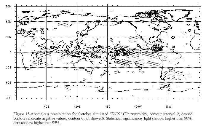
From observation of the precipitation differences between ensembles (Fig. 15), it can be seen the characteristic precipitation pattern associated with an ENSO warm event, with an increase (above climatology) in precipitation at tropical Pacific areas to the east of the most important positive SST anomalies imposed, and an adjacent horseshoe shaped U-pattern of negative anomalies associated to low level anomalous divergence. The simulated precipitation anomalies and the associated anomalous tropical heating must be good enough in amount as well as in location and vertical distribution in order to allow a simulation of the associated anomalous circulation with that level of agreement to the observed ones. We conclude that the model used can be seen as an useful tool to better describe and understand the observed anomalies associated to tropical heating anomalies, at less for some part of the large scale upper troposphere and lower stratosphere features, as the polar vortex alteration studied here.
The model capture very important features of the extratropical tropospheric and lower stratospheric anomalous circulation in the SH (for example the vortex modifications, in place, pattern and intensity) as well as the most relevant characteristics of the wave driven and forcing phenomena associated to the climatological October circulation.
The results obtained are promising in both senses: 1st) we are able to better understand an interesting phenomenon which links tropospheric and stratospheric anomalous circulation and, 2nd) we have tested and, now, better-know the UCLA-GCM as a relevant tool, capable of represent some of the most important effects involved in those phenomena. In any case we must be very careful in the interpretation of these results in view of the limitations intrinsic to the simulation performed. For example, as the ozone mixing ratios used in the radiation calculations are prescribed as a function of latitude, high and time but based in climatological values, no influence of the modified and transient circulation is expected via ozone transport on the stratospheric heating in the simulations, etc. Even with all the limitation that can be pointed out, new numerical experiments similar to this one are being planned at IMFIA-FI-UR in order to improve the understanding of the links between large scale phenomena in the SH troposphere and stratosphere.