Previous: Goals of this study Next:The UCLA-GCM Up: Ext. Abst.
Observed Circulation [1]
Changes in the circulation patterns of the stratospheric SH polar vortex are observed during years of extreme sea surface temperature (SST) anomalies at the equatorial Pacific Ocean during the austral spring.
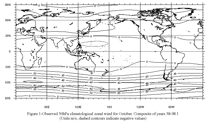
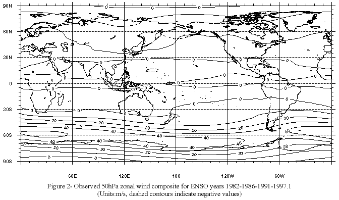
Differences between 50 hPa ("observed") climatological zonal wind for October (Fig. 1) and the composite of ("observed") El Niño-Southern Oscillation (ENSO) years 1982-86-91 and 97 (warm events) for zonal wind at the same level (Fig. 2), show a vortex anomaly resulting on a "shift" towards higher latitudes during these years to the southwest of South America. The composite anomaly of the 50 hPa zonal wind (Fig. 3) shows the strongest values (+/- 4 to 7 m/s on a background field of aprox. 40 m/s) between 160ºW and 80ºW (with peaks of the anomalies around 130ºW-120ºW). In this area the vortex strengthens at higher latitudes, around 75ºS, and weakens around 55ºS. That anomalous structure of the 50 hPa circulation is followed by similar anomalies of the zonal wind to the east, on the Atlantic flank of South America on the Antartic Peninsula, but with the sign reversed and smaller zonal scale.
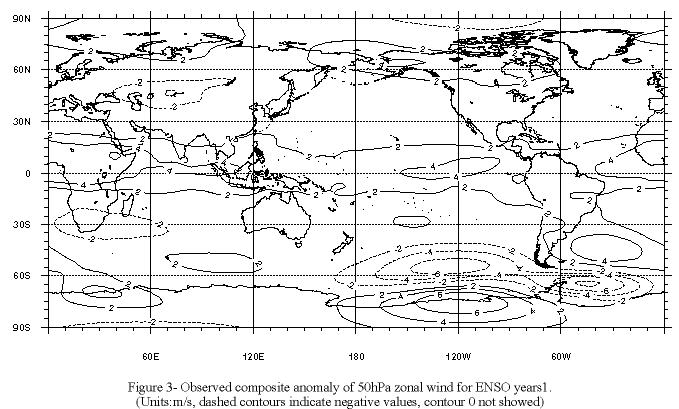
Those features result on a wavy structure of the stratospheric 50 hPa circulation during October of an EN (warm) event, or, in other words, a wave-like structure of the anomalous 50 hPa zonal wind field, perhaps forced from the central tropical Pacific region as in other EN-forced phenomena.
Correlation field between Niño 3-4 index and zonal wind at 50hPa (Fig. 4) show values higher than 0.4 at middle and high latitudes, with very similar pattern to that of circulation.
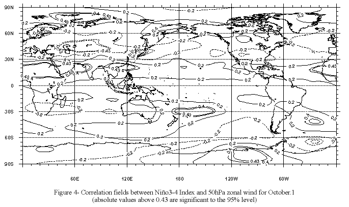
Note that for the Fig. 4 data which span 21 individual data for each year from 1979 to 1999, any correlation coefficient above 0.43 is statistically significant to the 95% level.
Therefore, it seems that the Central Pacific equatorial SST anomalies have a real effect on the Southern Hemisphere low stratosphere circulation, resulting on a less zonally-symmetric circulation during ENSO years than in the climatology (at that level).
[1] NCEP-Reanalysis- Data, Figs. and correlation maps were taken from and built based on the NCEP-Reanalysis, provided by the NOAA-CIRES CDC: www.cdc.noaa.gov/ ; (Kalnay, E. and Co-authors (1996).