1 National Institute for Environmental Studies, Tsukuba, Japan,
E-mail: hide@nies.go.jp
2 Earth Observation Research Center, National Space Development
Agency of Japan, Tokyo, Japan
3 Hokkaido University, Sapporo, Japan
# ILAS Web site: http://www-ilas.nies.go.jp/
FIGURES
Abstract
The Improved Limb Atmospheric Spectrometer (ILAS) onboard the ADEOS satellite made measurements of O3, HNO3, NO2, N2O, CH4, H2O, and aerosol extinction coefficients in both Arctic and Antarctic polar stratosphere from November 1996 to June 1997. We focused on time periods when polar vortices breakup in both hemispheres, i.e., November to December in 1996 for the Antarctic, and April to May in 1997 for the Arctic. We sorted all the measurements into the equivalent-latitude/potential-temperature coordinates. During the course of breakup of polar vortices, it was found that air, which contains higher mixing ratios of minor species (lower mixing ratio of H2O), mixed with the air inside the polar vortex through the polar vortex boundaries. Moreover, the altitudes where main bodies of minor species mixed were found to depend on species and hemispheres. For example, average altitudes for mixing were found to be about 600K for HNO3, 700K for aerosols, 800-900K for N2O, CH4, and H2O, and 1000K for O3 and NO2, respectively. Also mixing altitudes at the times of breakup of polar vortices are found to be higher in the Southern Hemisphere than the Northern Hemisphere.
1. Introduction
The Improved Limb Atmospheric Spectrometer (ILAS) is a solar-occultation satellite sensor developed by the Environment Agency of Japan (EA) for studying the stratospheric ozone layer environment [Sasano et al., 1997; Sasano et al., 1999a]. ILAS onboard the Advanced Earth Observing Satellite (ADEOS) was launched on August 17, 1996 from Tanegashima Space Center of the National Space Development Agency of Japan (NASDA).
After the launch and checkout period of ADEOS, ILAS started its normal operation from November 1, 1996. From then, ILAS has been working successfully and gathered about 6700 occultation measurements for 8 months until ADEOS lost its function in June 30, 1997.
ILAS measured O3, HNO3, NO2, N2O, CH4, H2O, and aerosol extinction coefficients in both Arctic and Antarctic polar stratosphere. Validations of ILAS measurements (Version 3.10 products) were done for O3 with ozonesondes [Sasano et al., 1999b] and with other satellite measurements [Lee et al., 1999], HNO3 with several balloon measurements [Koike et al., 2000], and aerosol extinction coefficients with SAGE II measurements [Burton et al., 1999]. Validations of other species and later versions were underway, but preliminary comparison shows very good agreement of each species with other correlative measurements. Here we used the latest Version 5.10/5.11 products for our current analysis.
2. Characteristics of ILAS Measurements
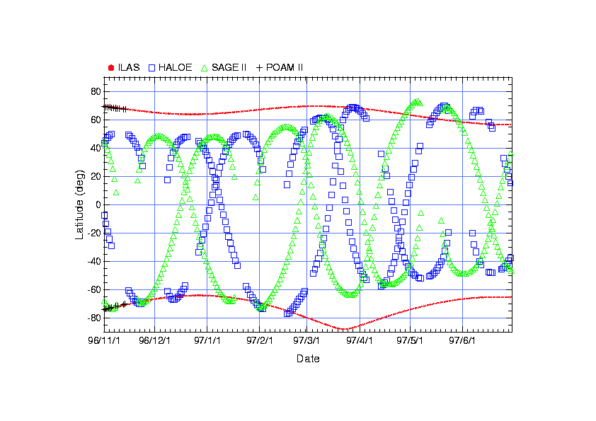
The orbit of the ADEOS is a sun-synchronized polar orbit at 10:30 LT. This orbit enabled solar-occultation ILAS measurements to achieve continuous coverage of high latitudes (57-73N and 64-88S) throughout the year. Figure 1 shows latitudinal coverage of ILAS during its operation period with a few other atmospheric satellite sensors like HALOE, SAGE II, and POAM II. It can be seen that only ILAS could cover the high latitude regions throughout the year. This is an advantage to monitor high-latitude ozone-related chemistry from winter to spring continuously.
Fig. 1. Latitudinal coverage of several satellite sensors
Figure 2 (a) and (b) shows the location of ILAS occultation measurements mapped on potential vorticity map at 475 K potential temperature surface on February 15, 1997 (a) and on May 11, 1997 (b) for the Northern Hemisphere. In Figure 2 (a), it can be seen that ILAS measured both inside and outside the polar vortex in a day even it covers very narrow geographical latitude area due to the oval shape of the polar vortex. Therefore, when we introduce use the equivalent latitude coordinate, ILAS measurements can cover relatively wide (equivalent-) latitudinal area due to the oval shape of the polar vortex.
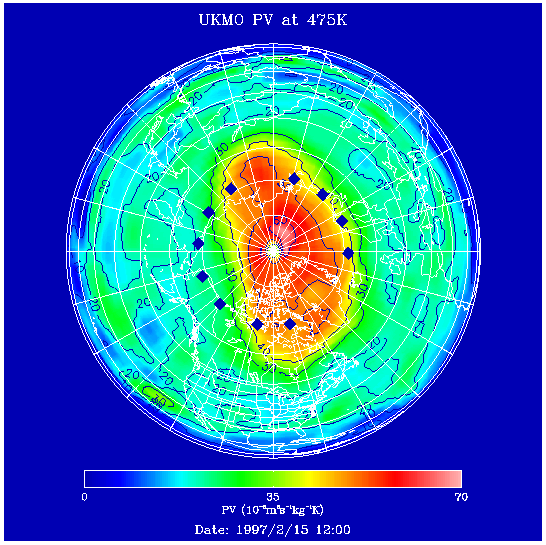
Fig. 2 (a). ILAS measurement locations (blue diamonds) mapped on potential vorticity map at 475 K on February 15, 1997.
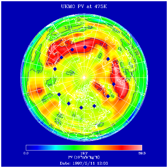
Fig. 2 (b). Same as Figure 2 (a) but for February 15, 1997.
3. Results
3.1. Dynamic Tracers
Mixing ratios of dynamic tracers (CH4 and N2O) measured by ILAS were plotted in Figures 3 and 4 in the equivalent latitude-potential temperature plane (hereafter, we call EL-PT plot) in each 10-days periods at the time of polar vortex breakup, i.e., 1996/11/1-10, 11/11-20, ..., 12/21-31 for the SH, and 1997/4/1-10, 4/11-20, ..., 5/21-31 for the NH. Polar vortex boundaries (inner, center, outer) defined with the method by Nash et al. [1996] are also plotted on these figures. It is shown that polar vortex started to break from upper altitudes. As the vortex breaks up, it can be seen that the air outside the vortex which contains higher mixing ratios of tracer species mixed with the air inside the vortex with smaller mixing ratios. This mixing started to occur at higher altitudes (900K for CH4, and 800K for N2O), followed by lower altitudes.
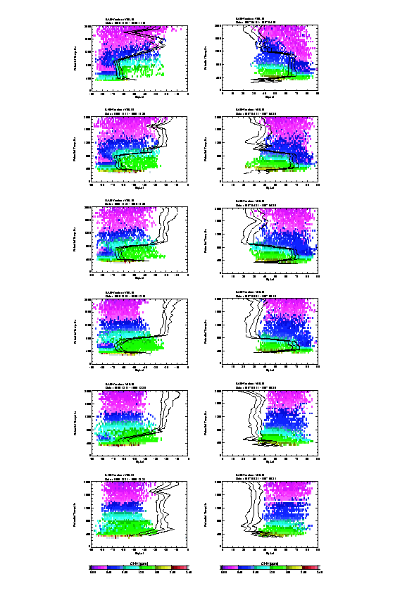
Fig. 3. Time variation of mixing ratio of CH4 in Equivalent Latitude-Potential Temperature plane.
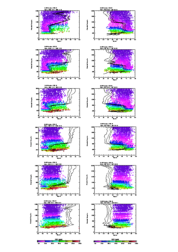
Fig. 4. Time variation of mixing ratio of N2O in Equivalent Latitude-Potential Temperature plane.
3.2. Photochemical Species
Mixing ratios of photochemical species (O3 and NO2) measured by ILAS were plotted in Figures 5 and 6 in the EL-PT plane in the same 10-days periods at the time of polar vortex breakup. It is shown that mixing of airmass occurred at much higher altitudes (1100K for O3, and 1000K for NO2) in earlier periods (11/11-20 for the SH, and 4/11-20 for the NH) compared with dynamic tracer cases (12/1-10 for the SH, and 5/1-10 for the NH). This is because polar vortex boundaries have disappeared earlier at higher altitudes. These differences in mixing altitude and time between photochemical species and dynamic tracers are caused mainly by the differences in vertical distribution of maximum mixing ratio. However, this could give us very good indication on how mixing of air between outside and inside the polar vortex occurs at the time of the breakup of polar vortex.
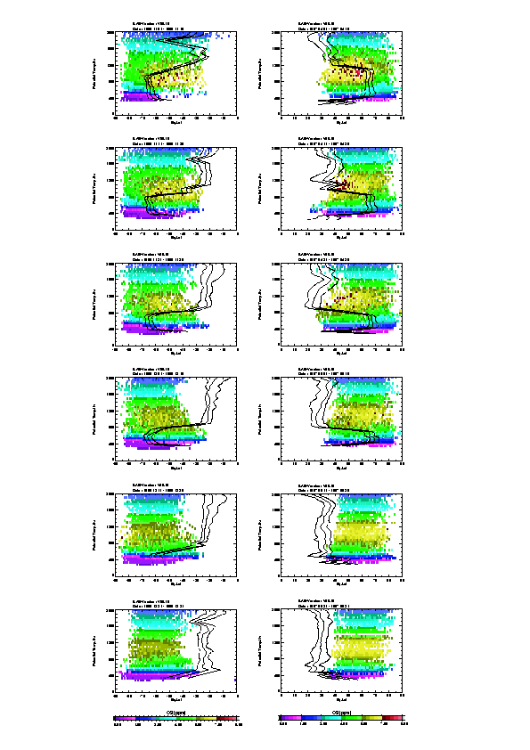
Fig. 5. Time variation of mixing ratio of O3 in Equivalent Latitude-Potential Temperature plane.
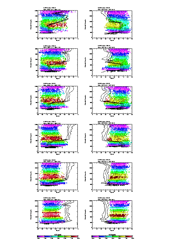
Fig. 6. Time variation of mixing ratio of NO2 in Equivalent Latitude-Potential Temperature plane.
3.3. Lower Stratospheric Species
Mixing ratios of HNO3, and aerosol extinction coefficients at 780 nm measured by ILAS were plotted in Figures 7 and 8 in the EL-PT plane in the same 10-days periods at the time of polar vortex breakup. It is shown that mixing of airmass occurred at lower altitudes (500-600K for both HNO3 and aerosols) in later periods (12/11-20 for the SH, and 5/11-20 for the NH) compared with dynamic tracer cases (12/1-10 for the SH, and 5/1-10 for the NH). This is because polar vortex boundaries breakup is later at lower altitudes. Again, these differences in mixing altitude and time give us very good indication on how mixing of air between outside and inside the polar vortex occurs at the time of the breakup of polar vortex. Also note that below 500K, polar vortex boundary is not stable even during winter, which enables mixing of air along the meridian.
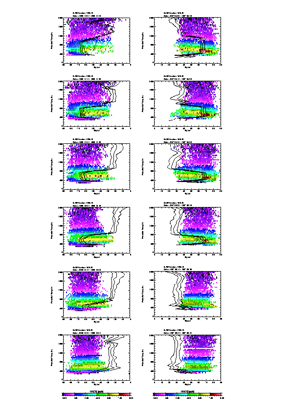
Fig. 7. Time variation of mixing ratio of HNO3 in Equivalent Latitude-Potential Temperature plane.
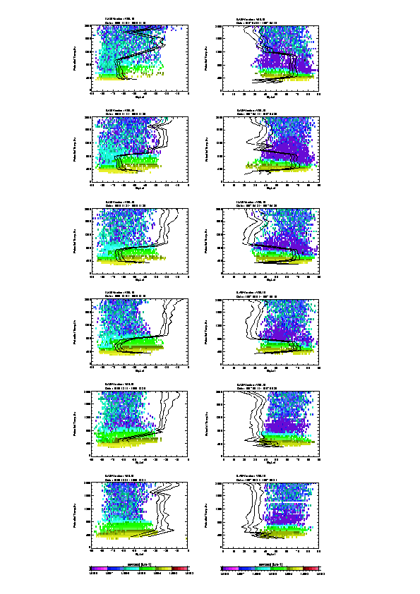
Fig. 8. Time variation of aerosol extinction coefficients at 780 nm in Equivalent Latitude-Potential Temperature plane.
3.4. Wind Field
In order to see how the vortex boundary is formed and how it started to disappear, horizontal wind velocities (SQRT(u*u+v*v)) are plotted in Figures 9 and 10 in EL-PT plane in the same 10-day periods at the time of polar vortex breakup. It is shown that strong winds of more than 40 m/s at +/- 60 degrees existed during the winter, which play an important role in separating air mass between inside and outside the polar vortex. It is clearly shown that this strong wind started to weaken and disappear from upper altitudes at the time of breakup of polar vortex, enabling the meridional mixing of air.
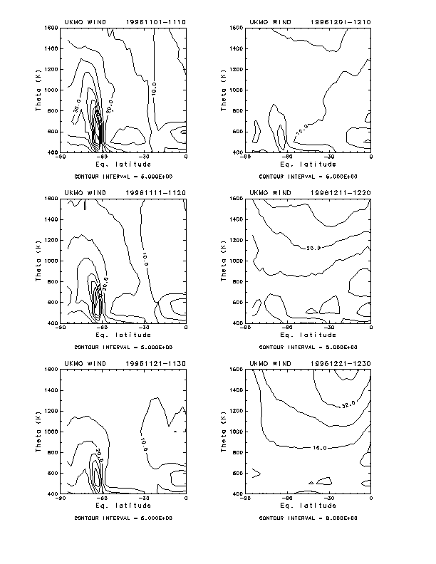
Fig. 9. Time variation of horizontal wind velocity field in Equivalent Latitude-Potential Temperature plane in the Southern Hemisphere for 10-day periods from November 1-10 to December 21-31, 1996.
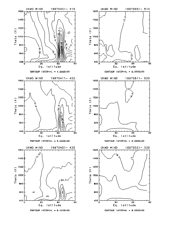
Fig. 10. Time variation of horizontal wind velocity field in Equivalent Latitude-Potential Temperature plane in the Northern Hemisphere for 10-day periods from April 1-10 to May 21-31, 1997.
4. Summary
Meridional mixing of air masses at the time of breakup of polar vortices in both SH and NH in 1996/1997 were investigated using the Improved Limb Atmospheric Spectrometer (ILAS) data onboard the ADEOS satellite. Mixing ratios of several minor species (CH4, N2O, O3, NO2, HNO3, and aerosols) were plotted in the Equivalent Latitude-Potential Temperature (EL-PT) coordinate in each 10-day periods, which enables us to investigate meridional distribution of these species even from a solar-occultation sensor data. It was shown that mixing ratios of these species were kept higher outside the polar vortex than inside, due to the existence of transport barrier which may be formed by the existence of strong wind at 60 degrees equivalent latitude. As polar vortex started to disappear from higher altitudes, meridional mixing of air mass started to occur from the higher altitude. This sometimes leave vortex interior air below the location where upper part is already outside the polar vortex, and form a kind of "double-peak" structure for species like CH4 or N2O. After the collapse of polar vortex, meridional distribution of minor species becomes very homogeneous. It was also shown that there were no strong polar vortex barriers below 500K throughout the winter, enabling easy meridional mixing of minor species.
References
Burton, S. P., L. W. Thomason, Y. Sasano, and S. Hayashida, Comparison of aerosol extinction measurements by ILAS and SAGE II, Geophys. Res. Lett., 26, 1719-1722, 1999.
Koike, M., Y. Kondo, H. Irie, F. J. Murcray, J. Williams, P. Fogal, R. Blatherwick, C. Camy-Peyret, S. Payan, H. Oelhaf, G. Wetzel, W. Traub, D. Johnson, K. Jucks, G. C. Toon, B. Sen, J. ?F. Blavier, H. Schlager, H. Ziereis, N. Toriyama, M. Y. Danilin, J. M. Rodoriguez, H. Kanzawa, and Y. Sasano, A comparison of Arctic HNO3 profiles measured by the Improved Limb Atmospheric Spectrometer and balloon-borne sensors, J. Geophys. Res., 105, 6761-6771, 2000.
Lee, K. M., J. M. Mcinerney, Y. Sasano, J. H. Park, W. Choi, and J. M. Russell III, Intercomparison of ILAS and HALOE ozone at high latitudes, Geophys. Res. Lett., 26, 835-838, 1999.
Sasano, Y., M. Suzuki, T. Yokota, and H. Kanzawa, Early results from Improved Limb Atmospheric Spectrometer (ILAS) measurements, Geocarto International, 12, 61-68, 1997.
Sasano, Y., M. Suzuki, T. Yokota, and H. Kanzawa, Improved Limb Atmospheric Spectrometer (ILAS) for stratospheric ozone layer measurements by solar occultatino technique, Geophys. Res. Lett., 26, 197-200, 1999a.
Sasano, Y., H. Nakajima, H. Kanzawa, M. Suzuki, T. Yokota, H. Nakane, H. Gernandt, A. Schmidt, A. Berber, V. Yushkov, V. Drokhov, and T. Deshler, Validation of ILAS Version 3.10 ozone with ozonesonde measurements, Geophys. Res. Lett., 26, 831-834, 1999b.
Back to
| Session 1 : Stratospheric Processes and their Role in Climate | Session 2 : Stratospheric Indicators of Climate Change |
| Session 3 : Modelling and Diagnosis of Stratospheric Effects on Climate | Session 4 : UV Observations and Modelling |
| AuthorData | |
| Home Page | |