NOAA Air Resources Laboratory, Silver Spring, Maryland, USA
Cooperative Institute for Research in Environmental Sciences, University of Colorado, Boulder, Colorado, USA
FIGURES
Abstract
1. Introduction
Recently, scientific attention to the roles of the stratosphere in the climate system has sparked renewed interest in the tropopause, particularly in the tropics. The transport of water vapor and other trace constituents through the tropical tropopause affects their concentration and distribution in the stratosphere. Long-term changes in the characteristics of the tropical tropopause may be associated with changes in stratospheric water vapor concentrations. Because increases in stratospheric water vapor, as demonstrated by balloon-borne frost-point hygrometer observations [Oltmans and Hofmann, 1995], have been postulated as playing a role in cooling the lower stratosphere [Forster and Shine, 1999] and depletion of ozone in the Arctic stratosphere [Kirk-Davidoff et al., 1999], a better understanding of tropical tropopause changes could clarify the causes of global and regional temperature and stratospheric ozone trends.
The passage of half a century since the main expansion of the radiosonde network, and the availability of new aerological datasets, afford the opportunity to develop a more temporally and spatially comprehensive depiction of the tropopause than ever before. Daily radiosonde data offer considerably better vertical resolution near the tropopause than either monthly radiosonde data, such as were employed by Highwood and Hoskins [1998], or model-based (re)analyses, as in the studies of Hoinka [1998, 1999], whose vertical resolution is similar to that of the mandatory radiosonde reporting levels. [The mandatory levels near the tropical tropopause are 150, 100, 70, and 50 hPa.] Furthermore, the use of daily soundings eliminates biases associated with using monthly data to vertically interpolate the tropopause level and to calculate variables, such as water vapor saturation mixing ratios, that are non-linearly related to observed temperature and heights at fixed pressure levels.
Here we present a new analysis of the climatological features of the tropical tropopause based on a thirty-year radiosonde dataset. We examine several "tropopause" levels including:
- the lapse-rate tropopause (LRT), formally defined by the World Meteorological Organization as "the lowest level at which the lapse rate decreases to 2 deg. C. per km or less, provided also the average lapse rate between this level and all higher levels within 2 km does not exceed 2 deg. C. per km" [WMO, 1957]
- the cold-point tropopause (CPT), identified as the location of the coldest point in the temperature sounding. This definition is preferred in studies of the cross-tropopause flux of water vapor in the tropics.
- the 100 hPa level, often used as a surrogate for the tropopause in the tropics
- the level at which water vapor saturation volume mixing ratio with respect to ice (qs) reaches a minimum value (qsmin).
2. Radiosonde data
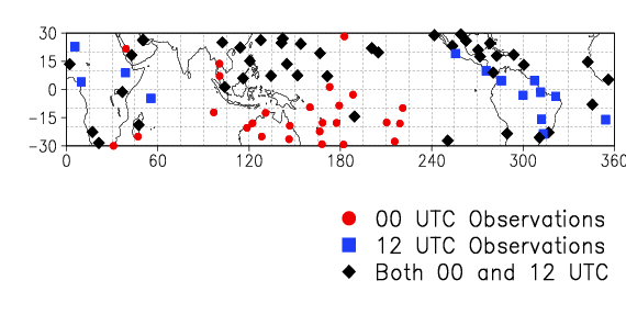
Radiosonde data are available from several sources, but the most complete archive is probably the Comprehensive Aerological Research Data Set [Eskridge et al., 1995], the source of observations for this study. We employed data from 83 radiosonde locations in the tropical belt (30N-30S), shown in Fig. 1. The focus of this abstract is climatological fields for the most recent climatic normal period 1961-90. The complete data record at some stations spans 1948-97, and we have employed data through 1997 in examining interannual variability and trends, which are not discussed here.
At each of the tropopause levels defined above, we retain or compute pressure (p), geopotential height (Z), temperature (T), potential temperature (theta), and qs. Monthly means were computed from individual soundings at each radiosonde site. Separate statistics for the 0000 and 1200 UTC observations were obtained whenever possible, and climatological monthly values were obtained by averaging values for each calendar month over the 30-yr period of record 1961-90. On average, 18 years of data were available for each station, and more than 80% of the stations contributed data for at least ten years. Although this network provides vastly better spatial coverage of the tropics than in earlier studies, serious data voids remain: 54% percent of the grid is unsampled, with few stations in the eastern Pacific, the Indian Ocean, and Africa.
Climatological values have been gridded at 10 degree latitude by 15 degree longitude resolution, with generally one or two stations per sampled gridbox (Fig. 1). For presentation purposes, gridded climatological means for 0000 and 1200 UTC were averaged, and data void regions were assigned the zonal-mean value based on the sampled boxes within the relevant latitude band.
Fig. 1. Locations of radiosonde stations used in this study. Red circles indicate only 0000 UTC data were used, blue squares indicate only 1200 UTC data were used, and filled diamonds indicate data at both observation times were used.
3. Tropopause characteristics
The tropical tropopause has strong zonal structure. Therefore, to summarize the characteristics of the LRT, CPT and 100 hPa level, Fig. 2 presents climatological annual-mean zonal-mean values of tropopause Z, p, T, and qs. The values are plotted at the central latitude of each 10 degree latitude zone. Fig. 3 presents comparable information on the longitudinal variability of these same variables in the equatorial zone (10N-10S), and Fig. 4 and Fig. 5 present the climatological seasonal variability of zonal mean values of these variables, and of theta, in the equatorial zone. These figures summarize the mean state of the tropical tropopause. The fuller spatial and seasonal variability of the tropopause are shown in Figs. 6,7,8,9, and 10, which are loops through the twelve months of the year of monthly climatological maps of Z (Fig. 6), p (Fig. 7), T (Fig. 8), and theta (Fig. 10) at the LRT and qsmin (Fig. 9).
3.1 Height
As depicted in Fig. 2, the height of LRT, ZLRT, shows considerable north-south variability, with values ranging from ~16.5 km in the deep tropics to less than16 km in the southern-most latitude band in this analysis. The CPT is up to ~1 km higher than the LRT but exhibits very little variability with latitude. The LRT and CPT definitions will indicate the same location if the coldest point of a sounding is at the base of an inversion layer deep enough (at least 2 km) to define the LRT. This situation is more likely in regions of frequent deep convection (the equatorial zone) than in regions of subsidence (the subtropics), where the cold point may reside at the top of a layer (whose base is the LRT) in which temperature is decreasing at a rate of 2 K/km or less.
On annual average, throughout much of the tropics, the 100 hPa level is intermediate in height to the CPT and LRT, residing at ~16.6 km and, like the CPT, shows little north-south variability. In the equatorial zone, the LRT and 100 hPa level are, on annual average, at approximately the same height (Fig. 3). However, the proximity of the climatological height of the 100 hPa level to the LRT and CPT, especially in the equatorial zone, is deceptive. As shown in <#Fig. 4>Fig. 4, the 100 hPa height is 16.5 km all year long, whereas the LRT and CPT are higher in NH winter (when the 100 hPa level is in the troposphere) and lower in NH summer (when the 100 hPa level is in the stratosphere).
As shown in Fig. 6, ZLRT is higher in the Northern Hemisphere (NH) than in the Southern Hemisphere (SH). This feature is more prominent in NH winter, when ZLRTmaxima reach 17.1 km over the western Atlantic region, over the northern part of South America and east of Central America. The location of the highest LRT is over north-equatorial Africa during most of the rest of the year. The location of maximum CPT height (not shown) is over Central America, at ~17.6 km, in December through March, and over various parts of Africa during the remaining months. We do not find the highest CPT, LRT, or 100 hPa level over the western tropical Pacific warm pool region during any month of the year.
3.2 Pressure
The structure of the tropical tropopause seen in climatological p fields is generally consistent with that shown in the Z fields. The pressure of the CPT is about 96 hPa, in an annual-mean zonal-mean sense, while the LRT is found between 100 and 115 hPa (Fig. 2). The differences between pCPT and pLRT are a few hPa in the equatorial zone (Fig. 3) and more than 10 hPa in the subtropics (Fig. 2). The maximum annual-mean equatorial pCPT values are just west of the International Dateline (Fig. 3). The monthly locations of minimum pCPT and pLRT are over Central America in NH winter (when pLRT = 91 hPa and pCPT = 83 hPa) and over Africa during other months (Fig. 6), fully consistent with the locations of maximum ZCPT and ZLRT, respectively.
3.3 Temperature
Climatological annual-mean zonal-mean tropopause T values are lowest in the NH equatorial zone (Fig. 2). The CPT is only slightly colder than the LRT, which is colder than the 100 hPa level. The higher 100 hPa level temperatures are the result of the fact that the 100 hPa level is generally in the upper troposphere during NH winter and in the lower stratosphere in NH summer, and both regions are warmer than the tropopause (Fig. 5). The difference between TLRT and TCPT is generally <1K in the tropics as a whole (Fig. 2), and <0.5K in the equatorial zone (Fig. 3). The differences in Z, p, and T at the LRT and CPT outside the equatorial zone depicted in Fig. 2 suggest the frequent existence of a second LRT (coinciding with the CPT) above the first LRT. Indeed, we find second tropopauses are three to four times as frequent poleward of 10 degrees latitude than in the deep tropics.
The meridional structure of annual-mean tropopause T in the equatorial zone, shown in Fig. 3, shows a distinct minimum (< 82 deg. C) in the 150-165E region (above Honiara and Truk) and slightly higher values in the region 165-180E (above Funafuti, Noumea, Tarawa, and Wake Island). Surprisingly, within the equatorial zone, on annual average, the longitudes at which the tropopause is coldest are not also those at which it is at highest height and lowest pressure. On the contrary, the CPT is coldest in the 150-165E region, where it is at lowest height and highest pressure.
The seasonal variability of equatorial tropopause T contrasts with that of tropospheric T (Fig 5). The former is dominated by the annual harmonic, while the latter (both at the surface and at 500 hPa) has a semi-annual signal, with maxima following the equinoxes. Some indication of this semi-annual harmonic appears in ZLRT and ZCPT (Fig. 4), which are better correlated with the temperature of the underlying troposphere than is TLRT. Lowest climatological monthly mean temperatures (-85C) are observed in NH winter in this region east of Indonesia (Fig. 8). In NH summer and early fall the tropopause is coldest (-81C) in the region further west, over Singapore, Thailand, and Malaysia; during April and November it is coldest (-84C) over Bogota.
3.4 Saturation mixing ratio of water vapor
As shown in Fig. 2, Fig. 3, and Fig. 5, qsmin values are visually almost indistinguishable from qs values at the LRT and CPT, which are generally not more than 5% greater than qsmin. Thus, although CPT and LRT pressures (and heights) can be significantly different, the closeness of their temperatures means that climatological qs determinations are nearly identical at both tropopause locations. At 100 hPa, qs is 10-25% higher than qsmin because of the higher temperatures at 100 hPa. In the equatorial zone, use of 100 hPa T to assess tropopause qs results in an overestimate of ~2 ppmv.
The variability of qsmin, shown in <#Fig. 9>Fig. 9 (and in <#Fig. 5>Fig. 5 for the equatorial zone), is highly correlated with that of TCPT. The lowest values (2.4 to 2.9 ppmv) are in the region 0-10N and 135-175E (over Koror, Majuro, Tarawa, and Truk) during December, January, and February. During other months, the local minima, ranging from 3.1 to 5.5 ppmv, can be found within the region 90-180E. On annual average (Fig. 3), much of the equatorial belt has climatological qsmin values of 5.8±2.6 ppmv (where 2.6 is approximately twice the interannual standard deviation).
3.5 Potential temperature
The seasonal variation of thetaLRT , shown in Fig. 4 and Fig. 10, reaches its peak in the equatorial zone during NH spring. Since theta is a function of both T and p, the high spring values are a consequence of the fact that TLRT has started to increase from its NH winter minimum (Fig. 8), but pLRT remains close to its winter level (Fig. 7). As shown in Fig. 4, the seasonal variations of theta100 are larger than, and out of phase with, the seasonal variations of thetaLRT and thetaCPT, further reinforcing the notion of 100 hPa level as a poor indicator of the tropical tropopause. We note that thetaLRT rarely reaches 380 K, the value suggested by Holton et al., [1995] as relevant to stratosphere-troposphere exchange in the tropics. Values of theta in the equatorial zone are typically between 365 and 375 K at the LRT, and between 370 and 380 K at the CPT.
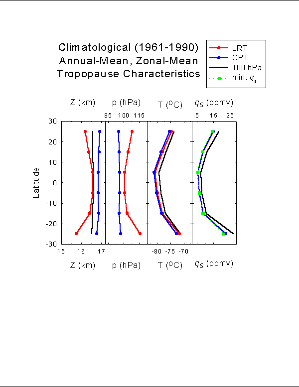
Fig. 2. Climatological mean characteristics of the lapse-rate tropopause (LRT), cold-point tropopause (CPT), and 100 hPa level. Annual-mean zonal-mean height, pressure, temperature, and water vapor saturation volume mixing ratio (qs) are based on gridded values computed from individual radiosoundings for 1961-90 from the 83 stations. Data represent means for 10 degree latitude bands, and are plotted at the midpoint of each band. In the fourth panel, annual-mean zonal-mean minimum values of qs (qsmin) are also shown.
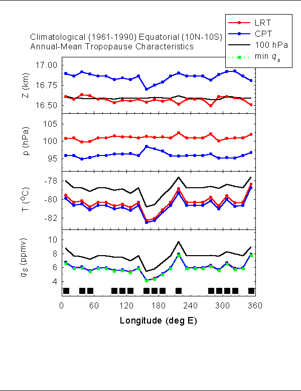
Fig 3. Climatological annual-mean height, pressure, temperature, and water vapor saturation volume mixing ratio in the equatorial zone (10N-10S) at the LRT, CPT, and 100 hPa level. In the fourth panel, qsmin data are also shown. Data points represent regions of 15 degree longitude width; those sampled by the radiosonde network are indicated by the squares along the abscissa. Unsampled regions have been assigned the zonal-mean values for presentation purposes.
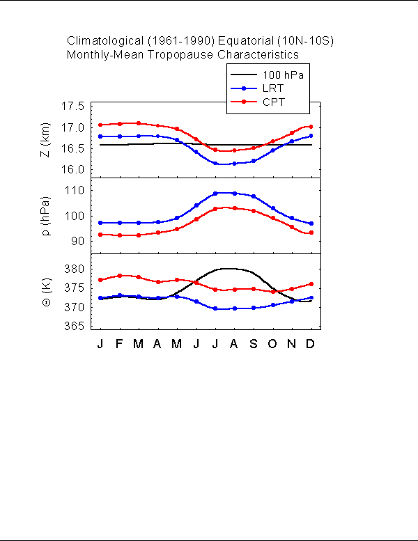
Fig. 4. Climatological seasonal cycles of height, pressure, and potential temperature in the equatorial zone (10N-10S) at the LRT, CPT, and 100 hPa level.
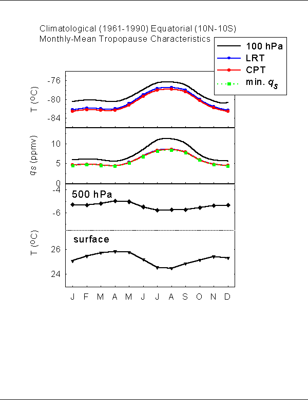
Fig. 5. Climatological seasonal cycles of temperature and water vapor saturation volume mixing ratio in the equatorial zone (10N-10S) at the LRT, CPT, and 100 hPa level. In the second panel, qsmin data are also shown. Tropospheric (surface and 500 hPa) temperatures in the same region are also shown.
If the following animated loops do not cycle properly, they can be seen at the SPARC Data Center : http://www.sparc.sunysb.edu/html/noaa/noaa_trop.html
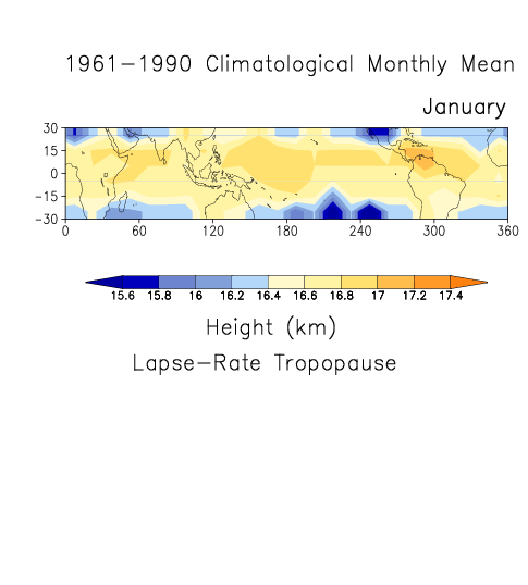
Fig. 6. The climatological annual cycle of the monthly mean height (km) of the lapse-rate tropopause based on 0000 and 1200 UTC data for 1961-90. Data based on radiosonde station values have been gridded, and unsampled grid boxes were assigned the zonal-mean value for presentation purposes. The figure loops through the twelve months of the year. (If the loops expire, reloading this file will start them anew. In these figures, two unintended blue horizontal lines appear. These are not data and should be disregarded.)
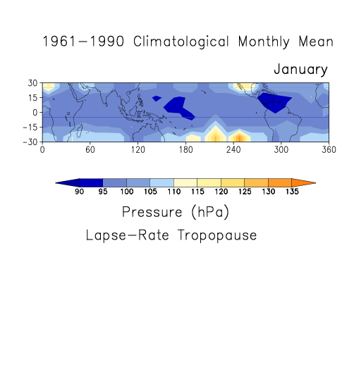
Fig. 7. The climatological annual cycle of the monthly pressure (hPa) of the lapse-rate tropopause based on 0000 and 1200 UTC data for 1961-90. (If the loops expire, reloading this file will start them anew. In these figures, two unintended blue horizontal lines appear. These are not data and should be disregarded.)
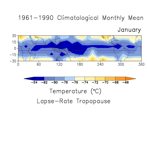
Fig. 8. The climatological annual cycle of the monthly mean temperature (C) of the lapse-rate tropopause based on 0000 and 1200 UTC data for 1961-90. (If the loops expire, reloading this file will start them anew. In these figures, two unintended blue horizontal lines appear. These are not data and should be disregarded.)
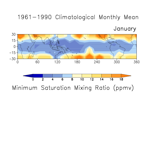
Fig. 9. The climatological annual cycle of the monthly mean minimum water vapor saturation volume mixing ratio (ppmv) based on 0000 and 1200 UTC data for 1961-90. (If the loops expire, reloading this file will start them anew. In these figures, two unintended blue horizontal lines appear. These are not data and should be disregarded.)
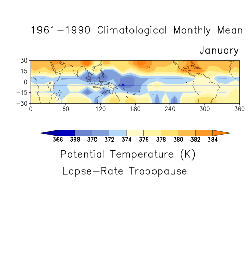
Fig. 10. The climatological annual cycle of the monthly mean potential temperature (K) of the lapse-rate tropopause based on 0000 and 1200 UTC data for 1961-90. (If the loops expire, reloading this file will start them anew. In these figures, two unintended blue horizontal lines appear. These are not data and should be disregarded.)
4. Summary
This paper presents a climatological depiction of the tropical tropopause based on radiosonde data from 83 stations covering the period 1961-1990. Our main findings are:
1. The location of the tropopause depends on the level by which it is defined. The climatological (1961-90) annual-mean zonal-mean LRT height varies from ~16.5 km in the equatorial zone to less than 16 km in the subtropics. The CPT resides at ~16.9 km, with very little north-south variability. The annual-mean zonal-mean pressure of the LRT is close to 100 hPa in the equatorial region, but higher in the subtropics. The CPT is generally at lower pressure, with an annual-mean zonal-mean location of about 96 hPa. The CPT is slightly colder than the LRT. In the equatorial zone, the annual-mean zonal-mean CPT temperature is about 81 deg. C, with corresponding water vapor saturation volume mixing ratio of 4 to 6 ppmv.
2. The tropopause is higher, colder, at lower pressure, and with lower saturation mixing ratio, in the Northern Hemisphere than in the Southern Hemisphere particularly in NH winter. The longitudes of minimum temperature (and saturation mixing ratio) differ from the longitudes of maximum height and minimum pressure. The tropopause is highest and at lowest pressure in the region over northern South America and east of Central America during NH winter, and over Africa during other months. However, it is coldest over the western tropical Pacific most of the year.
3. The 100 hPa level is a poor surrogate for the tropical tropopause. The 100 hPa height shows significantly less spatial and temporal variability than the heights of the LRT and CPT. In particular, the 100 hPa level lacks the seasonal variations of the tropopause and resides in the stratosphere during NH summer and in the troposphere during NH winter. Therefore, it is warmer in the mean than the LRT and CPT.
4. Water vapor saturation volume mixing ratios at the CPT and LRT are very close to the minimum values for a given profile (qsmin). However, values at the 100 hPa level are 10-25% higher.
5. Although not discussed above, comparison of our results with tropopause climatologies based on analyses or reanalysis [Highwood and Hoskins, 1998; Hoinka, 1998, 1999] suggests that the analyses depict the tropopause at lower elevation, and with less spatial structure, than the radiosonde data. This is probably due to the relatively poor vertical resolution of the analyses near the tropopause level. Comparison with an earlier climatology based on radiosonde data [Makhover, 1979] shows better agreement.
The dataset presented here is also amenable to studies of the interannual and longer-term variability of the tropical tropopause [Randel et al., 2000, Gaffen et al., submitted]. We hope it will also be useful in other investigations, such as comparisons with model simulations and process studies. We intend to make the data available to the scientific community in the near future.
References
Eskridge, R.E., O.A. Alduchov, I.V. Chernykh, Z. Panmao, A.C. Polansky, and S.R. Doty, A Comprehensive Aerological Research Data Set (CARDS): Rough and systematic errors, Bull. Amer. Meteor. Soc., 76, 1759-1775, 1995.
Forster, P.M. de F., and K.P. Shine, Stratospheric water vapour changes as a possible contributor to observed stratospheric cooling, Geophys. Res. Lett., 26, 3309-3312, 1999.
Gaffen, D.J., R.J. Ross, J.K. Angell, and G.C. Reid, Climatological characteristics of the tropical tropopause as revealed by radiosondes, submitted to J. Geophys. Res.
Highwood, E.J., and B.J. Hoskins, The tropical tropopause, Q. J. R. Meteorol. Soc., 124, 1579-1604, 1998.
Hoinka, K.P, Statistics of the global tropopause pressure, Mon. Weather Rev., 126, 3303-3325,1998.
Hoinka, K.P., Temperature, humidity, and wind at the global tropopause, Mon. Weather Rev., 127, 2248-2265, 1999.
Holton, J.R., P.H. Haynes, M.E. McIntyre, A.R. Douglass, R.B. Rood, and L. Pfister, Stratosphere-troposphere exchange, Rev. Geophys., 33, 403-439, 1995.
Kirk-Davidoff, D.B., E.J. Hinsta, J.G. Anderson, and D.W. Keith, The effect of climate change on ozone depletion through changes in stratospheric water vapour, Nature, 202, 399-401, 1999.
Makhover, Z. M., Features of the tropopause distribution over the globe, Meteor. Geophys., 12, 33-39, 1979 (in Russian).
Oltmans, S.J., and D.J. Hofmann, Increase in lower-stratospheric water vapour at a mid-latitude Northern Hemisphere site from 1981 to 1994, Nature, 374, 146-149,1995.
Randel, W.J., F. Wu, and D.J. Gaffen, Interannual variability of the tropical tropopause derived from radiosonde data and NCEP reanalyses, J. Geophys. Res., 105, 15,509-15,524, 2000.
WMO, Meteorology - A three-dimensional science: Second session of the commission for aerology, WMO Bulletin, vol. IV, no. 4, 134-138, 1957.
Back to
| Session 1 : Stratospheric Processes and their Role in Climate | Session 2 : Stratospheric Indicators of Climate Change |
| Session 3 : Modelling and Diagnosis of Stratospheric Effects on Climate | Session 4 : UV Observations and Modelling |
| AuthorData | |
| Home Page | |